On June 16, 2013, U.S. and French archeologists began examining an underwater object first discovered in 2001 near Poverty Island that could be the wreck of Le Griffon, a 17th century sailing ship, although it will take time to determine if it is even a shipwreck. Dean Anderson, the Michigan State Archeologist, examined the object, an alleged "bowsprit," and determined it to be a fishing net stake.[4]Le Griffon was the first full-sized European style sailing ship on the upper Great Lakes that was built and commanded by the French explorer René-Robert Cavelier, Sieur de La Salle in 1679. The ship disappeared with all six crew members and its cargo of furs after departing from Green Bay in Sept. of that same year on the return trip of her maiden voyage. The location and reason of her sinking has remained a mystery ever since.[5]
Lake Michigan is one of the five Great Lakes of North America. It is the second-largest of the Great Lakes by volume and the third-largest by surface area, after Lake Superior and Lake Huron. To the east, its basin is conjoined with that of Lake Huron through the 3+1⁄2-mile (5.6-kilometre) wide, 295-foot deep, Straits of Mackinac, giving it the same surface elevation as its easterly counterpart; the two are technically a single lake.
Le Griffon was a sailing vessel built by French explorer and fur trader René-Robert Cavelier, Sieur de La Salle in the Niagara area of Canada in 1679.
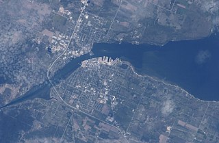
Sturgeon Bay is an arm of Green Bay extending southeastward approximately 10 miles into the Door Peninsula at the city of Sturgeon Bay, located approximately halfway up the Door Peninsula. The bay is connected to Lake Michigan by the Sturgeon Bay Ship Canal. The Potawatomi name for Sturgeon Bay is "Na-ma-we-qui-tong".
Porte des Morts, also known as Porte des Mortes, the Door of Death, and Death's Door is a strait linking Lake Michigan and Green Bay between the northern tip of the Door Peninsula and the southernmost of the Potawatomi Islands. At its narrowest reach between Plum Island and the peninsula, the Porte des Morts Passage is about one and one third miles across. The name is French and means "door of the dead".
The Door Peninsula is a peninsula in eastern Wisconsin, separating the southern part of the Green Bay from Lake Michigan. The peninsula includes northern Kewaunee County, northeastern Brown County, and the mainland portion of Door County. It is on the western side of the Niagara Escarpment. Well known for its cherry and apple orchards, the Door Peninsula is a popular tourism destination. With the 1881 completion of the Sturgeon Bay Ship Canal, the northern half of the peninsula became an island.
Chambers Island, named in honor of Col. Talbot Chambers, is a 2,834 acre island in Green Bay, about 7 miles (11 km) off the coast of the Door Peninsula, near Gibraltar, Wisconsin. It is part of the Town of Gibraltar in Door County.
Washington Island is an island of the state of Wisconsin situated in Lake Michigan. Lying about 7 miles (11 km) northeast of the tip of the Door Peninsula, it is part of Door County, Wisconsin. The island has a year-round population of 708 people according to the 2010 census. It has a land area of 60.9 km² and comprises over 92 percent of the land area of the town of Washington, as well as all of its population. The unincorporated community of Detroit Harbor is situated on the island. It is the largest in a group of islands that includes Plum, Detroit, Hog, Pilot, Fish, and Rock Islands. These islands form the Town of Washington. Detroit Harbor bay is on the south side of the island. A large part of Washington Island's economy is based on tourism.
The Garden Peninsula is a peninsula of 22 miles (35 km) in length that extends southwestward into Lake Michigan from the mainland of Michigan's Upper Peninsula. The peninsula is bordered by Lake Michigan on the east, and by Big Bay de Noc on the west. The base of the peninsula is served by U.S. Highway 2, and the peninsula's west shore is reached by M-183. The largest settlement on the peninsula is the village of Garden.
Rock Island is a mostly wooded island off the tip of Wisconsin's Door Peninsula at the mouth of Green Bay, in Door County, Wisconsin. The 974.87-acre (394.5 ha) island is approximately 1.6 miles (2.6 km) long and 1.1 miles (1.8 km) wide. It rises to 65 meters above Lake Michigan, making it the highest in elevation out of all the Potawatomi Islands. It is almost entirely owned by the Wisconsin Department of Natural Resources, which maintains Rock Island State Park. It is the northernmost part of the town of Washington.
Plum Island is an island in Lake Michigan in the southern part of the town of Washington in Door County, off the tip of the Door Peninsula in the U.S. state of Wisconsin. The uninhabited island has a land area of 1.179 square kilometres (0.455 sq mi) or 117.87 hectares. Carp Lake is located on the northwestern side. During years when Lake Michigan's water levels are high, it is a lagoon of Lake Michigan, but it gets cut off as a separate lake during low water years.
The Potawatomi Islands is the most common historic name given to the string of islands that delineate the transition from Green Bay to Lake Michigan, one of the Great Lakes. The archipelago is also termed the "Grand Traverse Islands".
St. Martin Island is located off the Garden Peninsula in Delta County in the U.S. state of Michigan. It is the southernmost island in Michigan that is part of a line of islands at the mouth of the bay of Green Bay and is part of the Niagara Escarpment.
Gull Island Light is a lighthouse on Gull Island, one of the Apostle Islands, in Lake Superior in northern Wisconsin, in Ashland County, Wisconsin USA. The lighthouse was constructed in 1928 and is currently owned by the Coast Guard. Both grounds and tower are closed.
Waugoshance Point is a 2.5-mile-long (4.0 km) cape or peninsula that juts into Lake Michigan from the northwest coast of the Lower Peninsula of the U.S. state of Michigan in Emmet County. It separates the Straits of Mackinac to its north from Sturgeon Bay to the south and is part of Wilderness State Park. The nearest town is Mackinaw City. Waugoshance is a hybrid word, that combines the Anishinaabemowin word wah'goosh and the French word anse.
Green Bay National Wildlife Refuge is a National Wildlife Refuge of the United States located in the state of Wisconsin. It includes five all or part of six islands in Lake Michigan: Hog Island, Plum Island, Pilot Island, part of St. Martin Island and Rocky Island. Additionally it includes part of Detroit Island. The islands are near Washington Island off the tip of the Door Peninsula of Wisconsin and the Garden Peninsula of Michigan.
The Wisconsin Islands Wilderness is a 29-acre (12 ha) wilderness area located in Door County in northeastern Wisconsin. It is one of the smallest wilderness areas in the United States. Managed by the U.S. Fish & Wildlife Service, the wilderness area is composed of three islands in Lake Michigan.
Hat Island is an island in Green Bay in Door County, Wisconsin. The island is part of the Town of Egg Harbor, and lies offshore from the community of Juddville. Hat Island is privately owned.
Gravel Island is an island in Lake Michigan. It is located in Ellison Bay, in the town of Liberty Grove, Wisconsin. The Gravel Island National Wildlife Refuge is made up of Gravel Island, and nearby Spider Island. The island is uninhabited, and a botanist who visited in 1999 was unable to find any vascular plants on the island.
The flora of Door County, Wisconsin comprise a variety of plant species. Geobotanically, Door County belongs to the North American Atlantic Region.
This page is based on this Wikipedia article Text is available under the CC BY-SA 4.0 license; additional terms may apply. Images, videos and audio are available under their respective licenses.