
Lake Michigan is one of the five Great Lakes of North America. It is the second-largest of the Great Lakes by volume and the third-largest by surface area, after Lake Superior and Lake Huron. To the east, its basin is conjoined with that of Lake Huron through the 3+1⁄2-mile (5.6-kilometer) wide, 295-foot deep Straits of Mackinac, giving it the same surface elevation as its easterly counterpart; geologically, the two bodies are a single lake that is, by area, the largest freshwater lake in the world.

Lake Superior is the largest freshwater lake in the world by surface area and the third-largest freshwater lake by volume, holding 10% of the world's surface fresh water. Located in central North America, it is the northernmost and westernmost of the Great Lakes of North America, straddling the Canada–United States border with the Canadian province of Ontario to the north and east and the U.S. states of Minnesota to the west and Michigan and Wisconsin to the south. It drains into Lake Huron via St. Marys River, then through the lower Great Lakes to the St. Lawrence River and ultimately the Atlantic Ocean.

Leelanau County is a county located in the U.S. state of Michigan. As of the 2020 census, the population was 22,301. Since 2008, the county seat has been located within Suttons Bay Township, one mile east of the unincorporated village of Lake Leelanau. Before 2008, Leelanau County's seat was Leland. Leelanau County is included in the Traverse City metropolitan area of Northern Michigan. The largest settlement in Leelanau County by population is Greilickville, itself a suburb of Traverse City.
Glen Arbor Township is a civil township of Leelanau County in the U.S. state of Michigan. The population was 757 at the 2020 census. However, the population of the town expands rapidly during the summer months as a result of it being a summer colony.
The St. Clair River is a 40.5-mile-long (65.2 km) river in central North America which flows from Lake Huron into Lake St. Clair, forming part of the international boundary between Canada and the United States and between the Canadian province of Ontario and the U.S. state of Michigan. The river is a significant component in the Great Lakes Waterway, whose shipping channels permit cargo vessels to travel between the upper and lower Great Lakes.

The geography of North Carolina falls naturally into three divisions — the Appalachian Mountains in the west, the central Piedmont Plateau, and the eastern Atlantic Coastal Plain. North Carolina covers 53,819 square miles (139,391 km2) and is 503 miles (810 km) wide by 150 miles (241 km) long. The physical characteristics of the state vary from the summits of the Smoky Mountains, an altitude of near seven thousand feet (2,130 m) in the west, sloping eastward to sea level along the coast and beaches of the Atlantic Ocean.

Sleeping Bear Dunes National Lakeshore is a U.S. national lakeshore in the northwestern Lower Peninsula of Michigan. Located within Benzie and Leelanau counties, the park extends along a 35-mile (56 km) stretch of Lake Michigan's eastern coastline, as well as North and South Manitou islands, preserving a total of 71,199 acres. The park is known for its outstanding natural features, including dune formations, forests, beaches, and ancient glacial phenomena. The lakeshore also contains many cultural features, including the 1871 South Manitou Island Lighthouse, three former stations of the Coast Guard, and an extensive rural historic farm district.

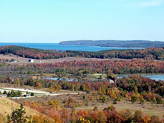
South Manitou Island is located in Lake Michigan, approximately 16 miles (26 km) west of Leland, Michigan. It is part of Leelanau County and the Sleeping Bear Dunes National Lakeshore. The uninhabited island is 8.277 sq mi (21.44 km2) in land area and can be accessed by a ferry service from Leland. Guided tours on open-air vehicles are available to visitors, but most traffic is on foot. Larger North Manitou Island lies to its north.
The Leelanau Peninsula is a peninsula of the U.S. state of Michigan that extends about 30 miles (50 km) from the western side of the Lower Peninsula of Michigan into Lake Michigan, forming Grand Traverse Bay. It is often referred to as the "little finger" of the mitten-shaped lower peninsula. The peninsula is a tourist hotspot, especially due to the popularity of Sleeping Bear Dunes National Lakeshore, which adorns the southwestern coast of the peninsula. The peninsula is also largely agricultural, and is a production hotspot for cherries and wine.

Leland is an unincorporated community and census-designated place (CDP) in the U.S. state of Michigan. It is located in Leelanau County, part of the northwestern Lower Peninsula of the state. As of the 2020 census it had a population of 410. From 1883 to 2004, Leland was the county seat of Leelanau County, which has since moved to Suttons Bay Township.
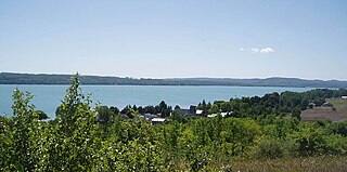
Lake Leelanau is a lake that is located in the Leelanau Peninsula of the U.S. state of Michigan. The lake is divided into two basins, usually referred to as North Lake Leelanau and South Lake Leelanau, which are divided by the Lake Leelanau Narrows in the community of Lake Leelanau. The entire lake covers about 8,608 acres (35 km2). The lake is drained by the Leland River, which flows to Lake Michigan in the community of Leland.

Northern Michigan, also known as Northern Lower Michigan, is a region of the U.S. state of Michigan. A popular tourist destination, it is home to several small- to medium-sized cities, extensive state and national forests, lakes and rivers, and a large portion of Great Lakes shoreline. The region has a significant seasonal population much like other regions that depend on tourism as their main industry. Northern Lower Michigan is distinct from the more northerly Upper Peninsula and Isle Royale, which are also located in "northern" Michigan. In the northernmost 21 counties in the Lower Peninsula of Michigan, the total population of the region is 506,658 people.

Grand Traverse Bay is an arm of Lake Michigan, located along the west coast of the Lower Peninsula of Michigan. The bay is separated from the rest of Lake Michigan by the Leelanau Peninsula. The bay is some 32 miles (51 km) long, ranges from 7 to 10 miles wide, and up to 620 feet (190 m) deep in spots. It is the second-largest bay of Lake Michigan, behind Green Bay.

Lake Chicago was a prehistoric proglacial lake that is the ancestor of what is now known as Lake Michigan, one of North America's five Great Lakes. Formed about 13,000 years ago and fed by retreating glaciers, it drained south through the Chicago Outlet River.

The geography of New York (state) varies widely. Most of New York is dominated by farms, forests, rivers, mountains, and lakes. New York's Adirondack Park is larger than any U.S. National Park in the contiguous United States. Niagara Falls, on the Niagara River as it flows from Lake Erie to Lake Ontario, is a popular attraction. The Hudson River begins near Lake Tear of the Clouds and flows south through the eastern part of the state without draining lakes George or Champlain. Lake George empties at its north end into Lake Champlain, whose northern end extends into Canada, where it drains into the Richelieu River and then the St. Lawrence. Four of New York City's five boroughs are on the three islands at the mouth of the Hudson River: Manhattan Island, Staten Island, and Brooklyn and Queens on Long Island.
Lake Leelanau is an unincorporated community and census-designated place (CDP) in Leelanau County, Michigan, near the lake of the same name. As of the 2020 census it had a population of 229. It is situated along M-204 at the "narrows" that separate North and South Lake Leelanau. The community is divided between Leland Township and Suttons Bay Township.

Michigan consists of two peninsulas surrounded primarily by four of the Great Lakes and a variety of nearby islands. The Upper Peninsula is bounded on the southwest by Wisconsin, and the Lower Peninsula is bounded on the south by Indiana and Ohio. Both land masses are also separated from the Canadian province of Ontario by waterways of the Great Lakes, and from each other by the Straits of Mackinac. Because its land is largely surrounded by the Great Lakes, which flow into the Saint Lawrence River, Michigan is the only U.S. state whose streams and rivers are almost entirely within the Great Lakes-St. Lawrence watershed.

The Pierce Stocking Scenic Drive is a scenic route within Sleeping Bear Dunes National Lakeshore, in western Northern Michigan in the United States. The roadway, with its "scenic vistas and gentle curves", is located off state highway M-109 between Empire and Glen Arbor. It runs for 7.4 miles (11.9 km) through forest and dunes areas, providing access to scenic overlooks of the Lake Michigan shoreline and the surrounding park land. Interpretive markers along the roadway are keyed to the National Park Service's printed guide to the drive. Over 80,000 vehicles make the trip, in addition to bicyclists, hikers and skiers who use the road each year.

SS Vernon was a wooden-hulled American passenger and package freighter that sank in a Lake Michigan storm on October 29, 1887, near Two Rivers, Wisconsin, with the loss of between 36 and 50 lives, making her one of the deadliest shipwrecks ever to have occurred in Wisconsin. Only one of the people on board survived.
