
Emmet County is a county located in the U.S. state of Michigan. As of the 2010 census, the population was 32,694. The county seat is Petoskey.
The United States lightship Huron (LV-103) is a lightvessel that was launched in 1920. She is now a museum ship moored in Pine Grove Park, Port Huron, St. Clair County, Michigan.

Wilderness State Park is a public recreation area bordering Lake Michigan, five miles southwest of Mackinaw City in Emmet County in Northern Michigan. The state park's 10,512 acres (4,254 ha) include 26 miles (42 km) of shoreline, diverse forested dune and swale complexes, wetlands, camping areas, and many miles of hiking trails. The state park is operated by the Michigan Department of Natural Resources, which has, as of 2006, approved a proposal that 4,492 acres (1,818 ha) be officially dedicated as a wilderness area. Wilderness State Park was designated a Michigan "dark sky preserve" in 2012.

Gravelly Shoals Light is an automated lighthouse that is an active aid to navigation on the shallow shoals extending southeast from Point Lookout on the western side of Saginaw Bay. The light is situated about 2.7 miles (4.3 km) offshore and was built to help guide boats through the deeper water between the southeast end of Gravelly Shoals and Charity Island. Architecturally this is considered to be Art Deco style.

Ile Aux Galets Light, also known as Skillagalee Island Light, is located on Ile Aux Galets, a gravelly, low-lying island in northeast Lake Michigan, between Beaver Island and the mainland, approximately 7 miles (11 km) northwest of Cross Village in Emmet County, Michigan. Along with nearby Grays Reef, Waugoshance, and White Shoal Lights, it warns shipping away from the reefs and shoals of Waugoshance Point, which pose an imminent hazard to navigation.
The DeTour Reef Light is a non-profit-operated lighthouse marking the southern entrance of the DeTour Passage between the eastern end of Michigan's Upper Peninsula and Drummond Island. The light is an automated active aid to navigation. It marks the northern end of Lake Huron. The passage is used by almost all of the Great Lakes commercial freighter traffic moving to and from Lake Superior, with approximately 5,000 vessel movements annually. It is said to be "the gateway to Lake Superior." In addition, many recreational boaters use the passage. The Light is located in Lake Huron, three miles (5 km) south of the nearest town, DeTour Village, Michigan.

A bird-cage lantern was the style of lantern common to American lighthouses in the early years of the nineteenth century. The lanterns received their name because of their appearance; they are shaped like wire bird cages.

Mackinaw Point marks the junction of Lake Michigan and Lake Huron. Founded in 1889, the Old Mackinac Point Light Station was in operation from 1890 until 1957.
The White Shoal Light is a lighthouse located 20 miles (32 km) west of the Mackinac Bridge in Lake Michigan. It is an active aid to navigation.

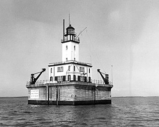
The lighthouse at Fourteen Foot Shoal was named to note that the lake is only 14 feet (4.3 m) deep at this point, which is a hazard to navigation, ships and mariners.
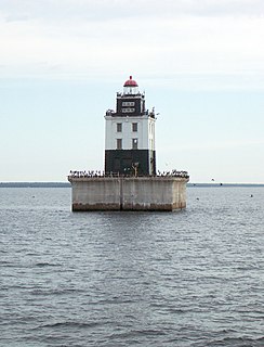
Poe Reef is a lighthouse located at the east end of South Channel between Bois Blanc Island and the mainland of the Lower Peninsula, about 6 miles (9.7 km) east of Cheboygan, Michigan.

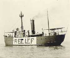
The lighthouse at Waugoshance protects boats from a shoal area at the northern end of Lake Michigan. The lighthouse is located in Emmet County, Michigan, United States, and in U.S. Coast Guard District No. 9.

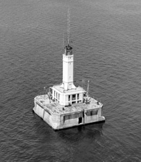
Spectacle Reef Light is a lighthouse 11 miles (18 km) east of the Straits of Mackinac and is located at the northern end of Lake Huron, Michigan. It was designed and built by Colonel Orlando Metcalfe Poe and Major Godfrey Weitzel, and was the most expensive lighthouse ever built on the Great Lakes.

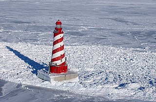
Round Island Passage Light is an automated, unmanned 1948 lighthouse located in the Round Island Channel in the Straits of Mackinac, Michigan. The channel is a branch of Lake Huron.

Michigan Islands Wilderness Area, a relatively small wilderness area of 12.5 acres (0.05 km2.), consists of Pismire Island, Scarecrow Island, and Shoe Island within the Michigan Islands National Wildlife Refuge. These three islands, which constitute part of the group of islands that make up the larger refuge, were elevated to the rank of a United States wilderness area in 1970. All three islands are noted for their infrequent human visitation and their roles as breeding grounds for freshwater wading birds, such as the great blue heron.
The Grays Reef Light is a lighthouse located in northeastern Lake Michigan, 3.8 miles (6.1 km) west of Waugoshance Island in Bliss Township, Michigan. It was listed on the National Register of Historic Places in 2005.

Ile Aux Galets, also known as Skillagallee or Skillagalee Island, is located in northeast Lake Michigan, between Beaver Island and the mainland, approximately 7 miles (11 km) northwest of Cross Village in Emmet County, Michigan. The island's Ile Aux Galets Light warns passing ships of a dangerous gravel shoal extending almost 2 miles (3.2 km) to the east and .5 miles (0.80 km) to the northwest, that poses an imminent hazard to navigation.

Temperance Island is an island off of Waugoshance Point, in Lake Michigan. It is located in Bliss Township of Emmet County, Michigan. Temperance and nearby Waugoshance Island are part of the Wilderness State Park. The Big Cut Canal separates the islands from Waugoshance Point. Together the islands form the northern boundary for sturgeon bay.


