
Laurel Blair Clark was an American NASA astronaut, medical doctor, United States Navy captain, and Space Shuttle mission specialist. She died along with her six fellow crew members in the Space Shuttle Columbia disaster. Clark was posthumously awarded the Congressional Space Medal of Honor.
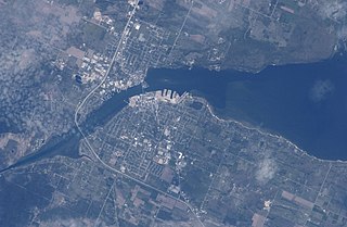
Sturgeon Bay is an arm of Green Bay extending southeastward approximately 10 miles into the Door Peninsula at the city of Sturgeon Bay, located approximately halfway up the Door Peninsula. The bay is connected to Lake Michigan by the Sturgeon Bay Ship Canal. The Potawatomi name for Sturgeon Bay is "Na-ma-we-qui-tong".

Chambers Island, named in honor of Col. Talbot Chambers, is a 2,834 acre island in Green Bay, about 7 miles (11 km) off the coast of the Door Peninsula, near Gibraltar, Wisconsin. It is part of the Town of Gibraltar in Door County.

Gills Rock is an unincorporated community located on Highway 42 at the northern tip of the Door Peninsula in Door County, Wisconsin, United States. It is within the town of Liberty Grove and was formerly known as Hedgehog Harbor.
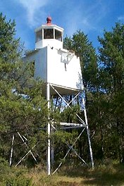
The Chequamegon Point Lighthouse is a lighthouse located on Long Island, one of the Apostle Islands, in Lake Superior in Ashland County, Wisconsin, near the city of Bayfield.

Washington Island is an island of the state of Wisconsin situated in Lake Michigan. Lying about 7 miles (11 km) northeast of the tip of the Door Peninsula, it is part of Door County, Wisconsin. The island has a year-round population of 708 people according to the 2010 census. It has a land area of 60.9 km2 and comprises over 92 percent of the land area of the town of Washington, as well as all of its population. The unincorporated community of Detroit Harbor is situated on the island. It is the largest in a group of islands that includes Plum, Detroit, Hog, Pilot, Fish, and Rock Islands. These islands form the Town of Washington. Detroit Harbor bay is on the south side of the island. A large part of Washington Island's economy is based on tourism.
Fish Creek is an unincorporated community located in Door County, Wisconsin, United States, within the town of Gibraltar. It is located on Highway 42 along Green Bay.

Rock Island is a mostly wooded island off the tip of Wisconsin's Door Peninsula at the mouth of Green Bay, in Door County, Wisconsin. The 974.87-acre (394.5 ha) island is approximately 1.6 miles (2.6 km) long and 1.1 miles (1.8 km) wide. It rises to 65 meters above Lake Michigan, making it the highest in elevation out of all the Potawatomi Islands. It is almost entirely owned by the Wisconsin Department of Natural Resources, which maintains Rock Island State Park. It is the northernmost part of the town of Washington.

Hog Island is an uninhabited island located off the eastern shore of Washington Island in the town of Washington, Door County, Wisconsin, United States. The island has a land area of 2.14 acres (8,656 m2) and an elevation of 10 feet or 20 feet above Lake Michigan.

Detroit Island is an island in Lake Michigan in the southern part of the town of Washington in Door County, Wisconsin, United States. The island has a land area of 2.578 km2, out of which 27.6% is open to the public. The northern end of the island borders the waters of Detroit Harbor.

Plum Island is an island in Lake Michigan in the southern part of the town of Washington in Door County, off the tip of the Door Peninsula in the U.S. state of Wisconsin. The uninhabited island has a land area of 1.179 square kilometres (0.455 sq mi) or 117.87 hectares. Carp Lake is located on the northwestern side. During years when Lake Michigan's water levels are high, it is a lagoon of Lake Michigan, but it gets cut off as a separate lake during low-water years.

Cana Island is an island in Lake Michigan in the town of Baileys Harbor in Door County, Wisconsin, United States. The Cana Island Light is on the east side of the island. It is possible to walk to Cana Island from the mainland over the tombolo when water levels are low. Tombolo conditions are monitored by a webcam operated by the county parks department. The island is part of the Town of Baileys Harbor, Wisconsin.
North Bay is a small Unincorporated community located on Lake Michigan in the town of Liberty Grove in northern Door County, Wisconsin. The North Bay State Natural Area along with a few resorts are located within the vicinity of the community. A Native American name for North Bay is "Wah-Sa-Ke-Ta-Ta-Wong", or "Burning Island".
Green Bay National Wildlife Refuge is a National Wildlife Refuge of the United States located in the state of Wisconsin. It includes five all or part of six islands in Lake Michigan: Hog Island, Plum Island, Pilot Island, part of St. Martin Island and Rocky Island. Additionally it includes part of Detroit Island. The islands are near Washington Island off the tip of the Door Peninsula of Wisconsin and the Garden Peninsula of Michigan.

The Strawberry Islands are a small chain of four islands located on the Wisconsin side of Green Bay between Chambers Island and Peninsula State Park. The islands are part of the Town of Gibraltar, Wisconsin.

Idlewild is an unincorporated community located in the town of Nasewaupee, Door County, Wisconsin, United States.
Coffee Swamp is a freshwater swamp located on the northern edge of Washington Island, in Door County Wisconsin and is a designated state natural area since 1994. At the center of the swamp is a small, shallow pond.

Detroit Harbor is a bay between the southern end of Washington Island, and the northern end of Detroit Island. It is located in Washington, Door County, Wisconsin. An unincorporated community also named Detroit Harbor is found on the northern side of the bay. There are three islands inside of the bay, Snake Island, Big Susie Island, and Little Susie Island. The bay is dredged on either side to allow boats through, forming the East and West channels. Both car and passenger ferries to Washington Island go through Detroit Harbor, before they dock. The United States Coast Guard maintains operations in Detroit Harbor through the Washington Island Station. Detroit Harbor is designated as a Wisconsin state natural area by the Wisconsin Department of Natural Resources.
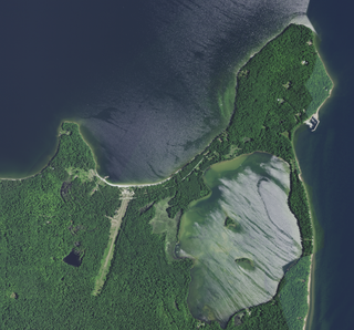
Mackaysee Lake is a lake located in Door County, Wisconsin. The lake is found on Chambers Island in Green Bay of Lake Michigan. Mackaysee Lake has a surface area of 347 acres (1.40 km2) and a max depth of 27 ft (8.2 m). Most of the lake has a sand bottom and is shallow with an average depth of 6 ft (1.8 m). There are two islands in Mackaysee Lake. Both are owned by the Door County Land Trust and are protected in the Chambers Island Nature Preserve. The islands are classified as third order recursive islands due to being in a lake on an island in a lake.
 West end
 East end


