Lake Michigan is one of the five Great Lakes of North America. It is the second-largest of the Great Lakes by volume and the third-largest by surface area, after Lake Superior and Lake Huron. To the east, its basin is conjoined with that of Lake Huron through the 3+1⁄2-mile (5.6-kilometer) wide, 295-foot deep Straits of Mackinac, giving it the same surface elevation as its easterly counterpart; geologically, the two bodies are a single lake that is, by area, the largest freshwater lake in the world.

Beaver Island is an island in Lake Michigan in the U.S. state of Michigan. At 55.8 sq mi (145 km2), it is the largest island in Lake Michigan and the third largest island in Michigan after Isle Royale and Drummond Island. The island is located approximately 32 miles (51 km) from the city of Charlevoix. Beaver Island had a total population of 616 at the 2020 census. Beaver Island is part of Charlevoix County.

Voyageurs National Park is an American national park in northern Minnesota near the city of International Falls established in 1975. The park's name commemorates the voyageurs—French-Canadian fur traders who were the first European settlers to frequently travel through the area. Notable for its outstanding water resources, the park is popular with canoeists, kayakers, other boaters, and fishermen. The Kabetogama Peninsula, which lies entirely within the park and makes up most of its land area, is accessible only by boat. To the east of the park lies the Boundary Waters Canoe Area Wilderness.
The protected areas of Michigan come in an array of different types and levels of protection. Michigan has five units of the National Park Service system. There are 14 federal wilderness areas; the majority of these are also tribal-designated wildernesses. It has one of the largest state forest systems as well having four national forests. The state maintains a large state park system and there are also regional parks, and county, township and city parks. Still other parks on land and in the Great Lakes are maintained by other governmental bodies. Private protected areas also exist in the state, mainly lands owned by land conservancies.

Wilderness State Park is a public recreation area bordering Lake Michigan, five miles southwest of Mackinaw City in Emmet County in Northern Michigan. The state park's 10,512 acres (4,254 ha) include 26 miles (42 km) of shoreline, diverse forested dune and swale complexes, wetlands, camping areas, and many miles of hiking trails. The state park is operated by the Michigan Department of Natural Resources, which has, as of 2006, approved a proposal that 4,492 acres (1,818 ha) be officially dedicated as a wilderness area. Wilderness State Park was designated a Michigan "dark sky preserve" in 2012.
Garden Island is an uninhabited 4,990 acre (20 km2) island located in the Beaver Island archipelago in northern Lake Michigan. It is almost wholly owned by the U.S. state of Michigan and is overseen by the Michigan Department of Natural Resources (DNR) as part of the Beaver Islands State Wildlife Research Area. It is accessible by private boat. The Native American name for the island is Minis Gitigaan, which has become Garden Island by direct translation. The Island's Native American cemetery was listed in the National Register of Historic Places in March 1978.
Hog Island, an uninhabited 2,075-acre (8 km2) island in Lake Michigan, is the fourth largest island in the Beaver Island archipelago. It is owned by the U.S. state of Michigan as part of the Beaver Islands State Wildlife Research Area and is administered by the Michigan Department of Natural Resources.
The Fox Islands consist of the North Fox and South Fox Islands, in Lake Michigan. The uninhabited islands are approximately 17 miles (27 km) northwest of Cathead Point near the tip of the Leelanau Peninsula of Michigan and about 10 miles (16 km) southwest of Beaver Island. The two islands form part of an archipelago. South Fox Island Light was built in 1867 and operated until 1959. Both islands are part of Leelanau County, Michigan, and are administered by Leelanau Township. Several shipwrecks have occurred on the Fox Islands, or the reefs adjoining them; in 1851, the Illinois was reported as a "total wreck" on the Fox Island reef, In 1860, the bark Fontanelle ran aground at the Fox Islands, and in 1861, the schooner Nightingale. In 1873, the ships Frank Perew and Magnet encountered trouble at the Fox Islands.

Hog Island is an uninhabited island located off the eastern shore of Washington Island in the town of Washington, Door County, Wisconsin, United States. The island has a land area of 2.14 acres (8,656 m2) and an elevation of 10 feet or 20 feet above Lake Michigan.

The Michigan Department of Natural Resources (DNR) is the agency of the state of Michigan founded in 1921, charged with maintaining natural resources such as state parks, state forests, and recreation areas. It is governed by a director appointed by the Governor and accepted by the Natural Resources Commission. Since 2023, the Director is Scott Bowen. The DNR has about 1,400 permanent employees, and over 1,600 seasonal employees.

A dark-sky preserve (DSP) is an area, usually surrounding a park or observatory, that restricts or reduces light pollution or maintains and protects naturally dark night skies. Different terms have been used to describe these areas as national organizations and governments have worked independently to create programs. DarkSky International (DarkSky) uses "International Dark Sky Reserve" (IDSR) and "International Dark Sky Park" (IDSP) among others when certifying Dark Sky Places.
Enzo Creek Nature Sanctuary, named after the creek that divides the sanctuary North to South, is a 150-acre (0.61 km2) privately managed wildlife sanctuary located in Mecosta County, Michigan, near the city of Big Rapids. The objective of the sanctuary is to enhance the habitat of the sanctuary for the benefit of the fish and wildlife which live within or migrate through the sanctuary.

Silver Springs State Fish and Wildlife Area is an Illinois state park on 1,350 acres (550 ha) in Kendall County, Illinois, United States. The park was established in the late 1960s and is named for the natural spring within its boundaries. The park has two artificial lakes and the Fox River flows through the northern end of the park. Silver Springs hosts a variety of activities including fishing, hunting, boating and hiking. The park has areas of native prairie restoration, a sledding hill and a seven-mile (11 km) equestrian trail. The prairie restoration areas hold many species of plants including lead plant, and purple coneflower.
The Potawatomi Islands is the most common historic name given to the string of islands that delineate the transition from Green Bay to Lake Michigan, one of the Great Lakes. The archipelago is also termed the "Grand Traverse Islands".

Lake Hudson State Recreation Area is a public recreation area located within southwestern Lenawee County in the U.S. state of Michigan. With its main entrance located along M-156, it is mostly located within Hudson Township and a very small portion extending south into neighboring Medina Township.

Pointe Mouillee State Game Area is a state game area in the U.S. state of Michigan. It encompasses 7,483 acres (30.3 km2) of hunting, recreational, and protected wildlife and wetland areas at the mouth of the Huron River at Lake Erie, as well as smaller outlying areas within the Detroit River. Pointe Mouillee State Game Area was established in 1945 and is administered by the Michigan Department of Natural Resources.
Green Bay National Wildlife Refuge is a National Wildlife Refuge of the United States located in the state of Wisconsin. It includes five all or part of six islands in Lake Michigan: Hog Island, Plum Island, Pilot Island, part of St. Martin Island and Rocky Island. Additionally it includes part of Detroit Island. The islands are near Washington Island off the tip of the Door Peninsula of Wisconsin and the Garden Peninsula of Michigan.
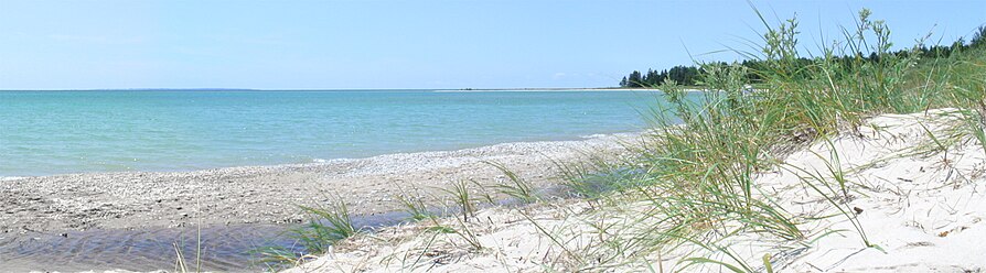 A beachfront on Iron Ore Bay on the southern shore of Beaver Island, with North Fox Island distantly visible in the left background.
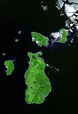
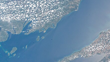 Beaver Islands (left), taken from the International Space Station; image is aligned with southeast at top