Lake Michigan is one of the five Great Lakes of North America. It is the second-largest of the Great Lakes by volume and the third-largest by surface area, after Lake Superior and Lake Huron. To the east, its basin is conjoined with that of Lake Huron through the 3+1⁄2 miles wide, 295 feet deep, Straits of Mackinac, giving it the same surface elevation as its easterly counterpart; the two are technically a single lake.

Door County is the easternmost county in the U.S. state of Wisconsin. As of the 2020 census, the population was 30,066. Its county seat is Sturgeon Bay. It is named after the strait between the Door Peninsula and Washington Island. The dangerous passage, known as Death's Door, contains shipwrecks and was known to Native Americans and early French explorers. The county was created in 1851 and organized in 1861. Nicknamed the “Cape Cod of the Midwest,” Door County is a popular Upper Midwest vacation destination. It is also home to a small Walloon population.
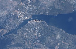
Sturgeon Bay is an arm of Green Bay extending southeastward approximately 10 miles into the Door Peninsula at the city of Sturgeon Bay, located approximately halfway up the Door Peninsula. The bay is connected to Lake Michigan by the Sturgeon Bay Ship Canal. The Potawatomi name for Sturgeon Bay is "Na-ma-we-qui-tong".

The Door Peninsula is a peninsula in eastern Wisconsin, separating the southern part of the Green Bay from Lake Michigan. The peninsula includes northern Kewaunee County, northeastern Brown County, and the mainland portion of Door County. It is on the western side of the Niagara Escarpment. Well known for its cherry and apple orchards, the Door Peninsula is a popular tourism destination. With the 1881 completion of the Sturgeon Bay Ship Canal, the northern half of the peninsula became an island.

Chambers Island, named in honor of Col. Talbot Chambers, is a 2,834 acre island in Green Bay, about 7 miles (11 km) off the coast of the Door Peninsula, near Gibraltar, Wisconsin. It is part of the Town of Gibraltar in Door County.

The Cana Island lighthouse is a lighthouse located just north of Baileys Harbor in Door County, Wisconsin, United States.

The Eagle Bluff Light, also known as Eagle Bluff lighthouse, or simply Eagle Bluff, is a lighthouse located near Ephraim in Peninsula State Park in Door County, Wisconsin. Construction was authorized in 1866, but the lighthouse was not actually built until 1868 at a cost of $12,000. It was automated in 1926. Restoration work began on the Eagle Bluff Light in 1960 and was completed in 1963, upon completion the Lighthouse was opened for tours. The lighthouse was added to the National Register of Historic Places in 1970.

The Plum Island Range Lights are a pair of range lights located on Plum Island in Door County, Wisconsin. They were part of the Plum Island United States Life-Saving Station. Plum Island was transferred to the United States Fish and Wildlife Service in 2007 and became part of the Green Bay National Wildlife Refuge. The life-saving station was listed on the National Register of Historic Places in 2010. Plum Island is seasonally open to the public for day-time use.
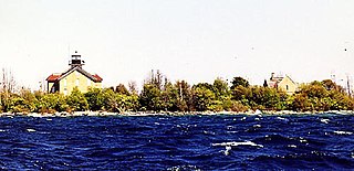
The Pilot Island Light is a lighthouse located near Gills Rock, on Pilot Island at the east end of Death's Door passage, in Door County, Wisconsin.

Washington Island is an island of the state of Wisconsin situated in Lake Michigan. Lying about 7 miles (11 km) northeast of the tip of the Door Peninsula, it is part of Door County, Wisconsin. The island has a year-round population of 708 people according to the 2010 census. It has a land area of 60.89 km² and comprises over 92 percent of the land area of the town of Washington, as well as all of its population. The unincorporated community of Detroit Harbor is situated on the island. It is the largest in a group of islands that includes Plum, Detroit, Hog, Pilot, Fish, and Rock Islands. These islands form the Town of Washington. Detroit Harbor bay is on the south side of the island. A large part of Washington Island's economy is based on tourism.

Detroit Island is an island in Lake Michigan in the southern part of the town of Washington in Door County, Wisconsin, United States. The island has a land area of 2.578 km², out of which 27.6% is open to the public. The northern end of the island borders the waters of Detroit Harbor.

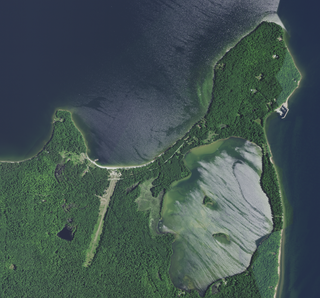
Plum Island is an island in Lake Michigan in the southern part of the town of Washington in Door County, off the tip of the Door Peninsula in the U.S. state of Wisconsin. The uninhabited island has a land area of 1.179 square kilometres (0.455 sq mi) or 117.87 hectares. Carp Lake is located on the northwestern side. During years when Lake Michigan's water levels are high, it is a lagoon of Lake Michigan, but it gets cut off as a separate lake during low water years.

Wisconsin, a state in the Midwestern United States, has a vast and diverse geography famous for its landforms created by glaciers during the Wisconsin glaciation 17,000 years ago. The state can be generally divided into five geographic regions—Lake Superior Lowland, Northern Highland, Central Plain, Eastern Ridges & Lowlands, and Western Upland. The southwestern part of the state, which was not covered by glaciers during the most recent ice age, is known as the Driftless Area. The Wisconsin glaciation formed the Wisconsin Dells, Devil's Lake, and the Baraboo Range. A number of areas are protected in the state, including Devil's Lake State Park, the Apostle Islands National Lakeshore, and the Chequamegon–Nicolet National Forest.

Cana Island is an island in Lake Michigan in the town of Baileys Harbor in Door County, Wisconsin, United States. The Cana Island Light is on the east side of the island. It is possible to walk to Cana Island from the mainland over the tombolo when water levels are low. Tombolo conditions are monitored by a webcam operated by the county parks department. The island is part of the Town of Baileys Harbor, Wisconsin.

Fish Island is an island on the western shore of Lake Michigan in the eastern part of the town of Washington in Door County, Wisconsin. It is two miles (3.2 km) southeast of Rock Island and is under the administration of the U.S. Government. It was named Fish Island because of the abundance of trout in the area.

Gravel Island is an island in Lake Michigan. It is located in Ellison Bay, in the town of Liberty Grove, Wisconsin. The Gravel Island National Wildlife Refuge is made up of Gravel Island, and nearby Spider Island. The island is uninhabited, and a botanist who visited in 1999 was unable to find any vascular plants on the island.

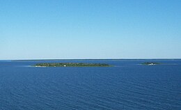
The Sister Islands are two islands in Lake Michigan. They are located in the bay of Green Bay, in the town of Liberty Grove, Wisconsin. At one point the islands were connected, but higher water levels have eroded the size of the islands. Combined, the area of the islands sits at 6 acres (2.4 ha).
The flora of Door County, Wisconsin comprise a variety of plant species. Geobotanically, Door County belongs to the North American Atlantic Region.
Mackaysee Lake is a lake located in Door County, Wisconsin. The lake is found on Chambers Island in Green Bay of Lake Michigan. Mackaysee Lake has a surface area of 347 acres (1.40 km2) and a max depth of 27 ft (8.2 m). Most of the lake has a sand bottom and is shallow with an average depth of 6 ft (1.8 m). There are two islands in Mackaysee Lake. Both are owned by the Door County Land Trust and are protected in the Chambers Island Nature Preserve. The islands are classified as third order recursive islands due to being in a lake on an island in a lake.
 Stitched panorama showing all four Strawberry Islands
 Boys building kayaks at Adventure Island Camp. Adventure Island is also known as Big Strawberry Island.
 Jack Island, diagram drawn after a visit by airplane in 1976
 Little Strawberry Island, diagram drawn from observations made in 1975 or shortly before