
Lake Michigan is one of the five Great Lakes of North America. It is the second-largest of the Great Lakes by volume and the third-largest by surface area, after Lake Superior and Lake Huron. To the east, its basin is conjoined with that of Lake Huron through the narrow Straits of Mackinac, giving it the same surface elevation as its easterly counterpart; the two are technically a single lake.

The Mackinac Bridge is a suspension bridge spanning the Straits of Mackinac to connect the Upper and Lower Peninsulas of the U.S. state of Michigan. Opened in 1957, the 26,372-foot-long bridge is the world's 24th-longest main span and the longest suspension bridge between anchorages in the Western Hemisphere. The Mackinac Bridge is part of Interstate 75 and the Lake Michigan and Huron components of the Great Lakes Circle Tour across the straits; it is also a segment of the U.S. North Country National Scenic Trail. The bridge connects the city of St. Ignace on the north end with the village of Mackinaw City on the south.

The Upper Peninsulaof Michigan – also known as Upper Michigan or colloquially the U.P. – is the northern of the two major peninsulas that make up the U.S. state of Michigan. It is bounded primarily by Lake Superior to the north, separated from the Canadian province of Ontario at the east end by the St. Marys River, and flanked by Lake Huron and Lake Michigan along much of its south. The Straits of Mackinac separate it from the Lower Peninsula of Michigan to the south. Although the peninsula extends as a geographic feature into the state of Wisconsin, the state boundary follows the Montreal and Menominee rivers and a line connecting them.

Mackinac Island is an island and resort area, covering 4.35 square miles (11.3 km2) in land area, in the U.S. state of Michigan. It is located in Lake Huron, at the eastern end of the Straits of Mackinac, between the state's Upper and Lower Peninsulas. The island was long home to an Odawa settlement and previous indigenous cultures before European colonization began in the 17th century. It was a strategic center of the fur trade around the Great Lakes. Based on a former trading post, Fort Mackinac was constructed on the island by the British during the American Revolutionary War. It was the site of two battles during the War of 1812 before the northern border was settled and the US gained this island in its territory.

Mackinac County is a county in the Upper Peninsula of the U.S. state of Michigan. As of the 2010 census, the population was 11,113. The county seat is St. Ignace. Formerly known as Michilimackinac County, in 1818 it was one of the first counties of the Michigan Territory, as it had long been a center of French and British colonial fur trading, a Catholic church and Protestant mission, and associated settlement.

Emmet County is a county located in the U.S. state of Michigan. As of the 2010 census, the population was 32,694. The county seat is Petoskey.

Garfield Township is a civil township of Mackinac County in the U.S. state of Michigan. The population was 1,146 at the 2010 census.
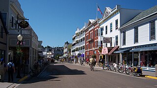
Mackinac Island is a city in Mackinac County in the U.S. state of Michigan. In the 2010 census, the city had a permanent population of 492. The summer population numbers in the thousands due to an influx of summer visitors and hundreds of seasonal workers.

Saint Ignace, usually written as St. Ignace, is a city near the tip of the Upper Peninsula of the US state of Michigan, on the northern side of the Straits of Mackinac. It sits on the shore of Lake Huron at the north end of the Mackinac Bridge, opposite Mackinaw City, serving as the gateway to the UP for travelers coming from the Lower Peninsula. It is one of two ports with ferry service to Mackinac Island, and is the only mainland city accessible from the island when Lake Huron is frozen over. St. Ignace Township is located just to the north of the city, but is politically independent.

Mackinaw City is a village in Emmet and Cheboygan counties in the U.S. state of Michigan. The population was 806 at the 2010 census; the population surges during the summer tourist season, including an influx of tourists and seasonal workers who serve in the shops, hotels and other recreational facilities there and in the surrounding region. Mackinaw City is at the northern tip (headland) of the Michigan's Lower Peninsula along the southern shore of the Straits of Mackinac. Across the straits lies the state's Upper Peninsula. These two land masses are physically connected by the Mackinac Bridge, which runs from Mackinaw City north to St. Ignace. Mackinaw City is also the primary base for ferry service to Mackinac Island, located to the northeast in the straits.

The Territory of Michigan was an organized incorporated territory of the United States that existed from June 30, 1805, until January 26, 1837, when the final extent of the territory was admitted to the Union as the State of Michigan. Detroit was the territorial capital.

The Straits of Mackinac are narrow waterways in the U.S. state of Michigan between Michigan's Lower and Upper Peninsulas. The main strait flows under the Mackinac Bridge and connects two of the Great Lakes, Lake Michigan and Lake Huron. The main strait is 3.5 miles (5.6 km) wide and has a maximum depth of 295 feet (90 m). Hydrologically, the two connected lakes can be considered one lake, which is called Lake Michigan–Huron. Historically, the native Odawa people called the region around the Straits Michilimackinac. The Straits of Mackinac are "whipsawed by currents unlike anywhere else in the Great Lakes".

Fort Michilimackinac was an 18th-century French, and later British, fort and trading post at the Straits of Mackinac; it was built on the northern tip of the lower peninsula of the present-day state of Michigan in the United States. Built around 1715, and abandoned in 1783, it was located along the Straits, which connect Lake Huron and Lake Michigan of the Great Lakes of North America. Present-day Mackinaw City developed around the site of the fort, which has been designated as a National Historic Landmark. It is preserved as an open-air historical museum, with several reconstructed wooden buildings and palisade.
M-185 is a state trunkline highway in the U.S. state of Michigan that circles Mackinac Island, a popular tourist destination on the Lake Huron side of the Straits of Mackinac, along the island's shoreline. A narrow paved road of 8.004 miles (12.881 km), it offers scenic views of the straits that divide the Upper and the Lower peninsulas of Michigan and Lakes Huron and Michigan. It has no connection to any other Michigan state trunkline highways—as it is on an island—and is accessible only by passenger ferry. The City of Mackinac Island, which shares jurisdiction over the island with the Mackinac Island State Park Commission (MISPC), calls the highway Main Street within the built-up area on the island's southeast quadrant, and Lake Shore Road elsewhere. M-185 passes by several important sites within Mackinac Island State Park, including Fort Mackinac, Arch Rock, British Landing, and Devil's Kitchen. Lake Shore Road carries the highway next to the Lake Huron shoreline, running between the water's edge and woodlands outside the downtown area.
Mackinac Island State Park is a state park located on Mackinac Island in the U.S. state of Michigan. A Lake Huron island, it is near the Straits of Mackinac. The island park encompasses 2.81 mi² (7.28 km²), which is approximately 80% of the island's total area of 3.78 mi² (9.78 km²). The park is also within the boundaries of the city of Mackinac Island and has permanent residents within its boundaries. M-185 circles the perimeter of the park as the only motorless highway in the state due to the island's ban of automobiles. The park is governed by the Michigan Department of Natural Resources and the Mackinac Island State Park Commission. On July 15, 2009, the park celebrated its 20 millionth visitor.

This is a list of the National Register of Historic Places listings in Mackinac County, Michigan.

The Garlyn Zoo is a zoo located in Mackinac County, Michigan. At 30 acres (120,000 m2), it is the largest zoo in the Eastern Upper Peninsula of Michigan.

Mackinac County Airport is a county-owned public-use airport in Mackinac County, Michigan, United States. It is located 2 nautical miles northwest of the central business district of St. Ignace. It is the closest airport to Mackinac Island Airport with a refueling station and is a major stopover destination for flights to and from Mackinac Island that require refueling. The airport is included in the Federal Aviation Administration (FAA) National Plan of Integrated Airport Systems for 2017–2021, in which it is categorized as a local general aviation facility.
Great Lakes Air is an American fixed-base operator and charter airline based in Mackinac County Airport in St. Ignace, Michigan.

