Garfield Township, Mackinac County, Michigan

Last updated

Garfield Township, Michigan
Garfield Township (Mackinac County), MI hall.jpg
Garfield Township Municipal Building
Garfield Township (Mackinac), MI location2.png
Location within Mackinac County
USA Michigan location map.svg
Red pog.svg
Garfield Township
Location within the state of Michigan
Usa edcp location map.svg
Red pog.svg
Garfield Township
Location within the United States
Coordinates: 46°08′40″N85°30′23″W / 46.14444°N 85.50639°W / 46.14444; -85.50639
CountryUnited States
State Michigan
County Mackinac
Government
  SupervisorDonald Butkovitch
   Clerk Paula Fillman
Area
[1]
  Total137.56 sq mi (356.28 km2)
  Land134.52 sq mi (348.41 km2)
  Water3.04 sq mi (7.87 km2)
Elevation
663 ft (202 m)
Population
 (2020) [2]
  Total1,166
  Density8.52/sq mi (3.29/km2)
Time zone UTC-5 (Eastern (EST))
  Summer (DST) UTC-4 (EDT)
ZIP Codes
49762 (Naubinway)
49827 (Engadine)
Area code 906
FIPS code 26-097-31620 [3]
GNIS feature ID1626339 [4]

Garfield Township is a civil township of Mackinac County in the U.S. state of Michigan. The population was 1,146 at the 2010 census, [5] and 1,166 in 2020. [6]

Contents

Geography

The township is in western Mackinac County. It is bordered by Portage Township and Newton Township to the west and Hudson Township to the east, all in Mackinac County, and by Pentland Township in Luce County to the north. The southern border of the township is the shore of Lake Michigan.

Garfield Township is the location of the northernmost point of Lake Michigan. The location, near Naubinway, was designated as a Michigan State Historic Site named "the Northernmost Point of Lake Michigan" on April 14, 1964. This point was used to draw the westernmost boundary of the Michigan Territory when it was created in 1805. West of this point belonged to the Indiana Territory until the Michigan Territory expanded westward in 1818. [7]

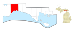
According to the United States Census Bureau, Garfield Township has a total area of 137.56 square miles (356.28 km2), of which 134.52 square miles (348.41 km2) are land and 3.04 square miles (7.87 km2) (2.26%) are water. [1]

Communities

Transportation

Highways

Bus service

Related Research Articles

<span class="mw-page-title-main">Mackinac County, Michigan</span> County in Michigan, United States

Mackinac County is a county in the Upper Peninsula of the U.S. state of Michigan. As of the 2020 census, the population was 10,834. The county seat is St. Ignace. Formerly known as Michilimackinac County, in 1818 it was one of the first counties of the Michigan Territory, as it had long been a center of French and British colonial fur trading, a Catholic church and Protestant mission, and associated settlement.

Wayland Township is a civil township of Allegan County in the U.S. state of Michigan. The population was 3,088 at the 2010 census.

<span class="mw-page-title-main">St. James Township, Michigan</span> Civil township in Michigan, United States

St. James Township is a civil township of Charlevoix County in the U.S. state of Michigan. The population was 365 at the 2010 census.

<span class="mw-page-title-main">Raber Township, Michigan</span> Civil township in Michigan, United States

Raber Township is a civil township of Chippewa County in the U.S. state of Michigan. The population was 647 at the 2010 census.

<span class="mw-page-title-main">Garfield Township, Clare County, Michigan</span> Civil township in Michigan, United States

Garfield Township is a civil township of Clare County in the U.S. state of Michigan. The population was 1,807 at the 2020 census.

<span class="mw-page-title-main">Bois Blanc Township, Michigan</span> Civil township in Michigan, United States

Bois Blanc Township is a civil township of Mackinac County in the U.S. state of Michigan. The population was 100 at the 2020 census. The insular township occupies Bois Blanc Island, as well as some smaller outlying islands within Lake Huron. The nearby Round Island is administered by the city of Mackinac Island.

<span class="mw-page-title-main">Hendricks Township, Michigan</span> Civil township in Michigan, United States

Hendricks Township is a civil township of Mackinac County in the U.S. state of Michigan. The population was 117 at the 2020 census, down from 153 in 2010.

<span class="mw-page-title-main">Hudson Township, Mackinac County, Michigan</span> Civil township in Michigan, United States

Hudson Township is a civil township of Mackinac County in the U.S. state of Michigan. As of the 2020 census, its population was 193.

<span class="mw-page-title-main">Moran Township, Michigan</span> Civil township in Michigan, United States

Moran Township is a civil township of Mackinac County in the U.S. state of Michigan. The population was 1,029 at the 2020 census.

<span class="mw-page-title-main">Newton Township, Mackinac County, Michigan</span> Civil township in Michigan, United States

Newton Township is a civil township of Mackinac County in the U.S. state of Michigan. As of 2020, its population was 430.

<span class="mw-page-title-main">Brevort, Michigan</span> Unincorporated community in Michigan, United States

Brevort is an unincorporated community in Mackinac County in the U.S. state of Michigan. The community is located along the northern shores of Lake Michigan along U.S. Route 2 within Moran Township. As an unincorporated community, Brevort has no legally defined boundaries or population statistics of its own.

<span class="mw-page-title-main">Gould City, Michigan</span> Unincorporated community in Michigan, United States

Gould City is an unincorporated community in Mackinac County in the U.S. state of Michigan. The community is located within Newton Township. As an unincorporated community, Gould City has no legal autonomy of its own but does have its own post office with the 49838 ZIP Code.

Black River is an 11.0-mile-long (17.7 km) river on the Upper Peninsula of the U.S. state of Michigan. The river flows into Lake Michigan at 46°05′37″N85°20′30″W, approximately 5 miles (8 km) east of Naubinway.

<span class="mw-page-title-main">Engadine, Michigan</span> Unincorporated community in Michigan, United States

Engadine is an unincorporated community in Mackinac County in the U.S. state of Michigan. The community is located within Garfield Township. As an unincorporated community, Engadine has no legally defined boundaries or population statistics of its own but does have its own post office with the 49827 ZIP Code.

<span class="mw-page-title-main">Naubinway, Michigan</span> Census-designated place in Michigan, United States

Naubinway is an unincorporated community and census-designated place (CDP) in Mackinac County in the U.S. state of Michigan. The population of the CDP was 147 at the 2020 census, the first year that it was recorded by the census. The community is located within Garfield Township.

<span class="mw-page-title-main">Epoufette, Michigan</span> Unincorporated community in Michigan, United States

Epoufette is an unincorporated community in Mackinac County in the U.S. state of Michigan. The community is located along the northern shores of Lake Michigan along U.S. Route 2 within Hendricks Township. As an unincorporated community, Epoufette has no legally defined boundaries or population statistics of its own.

<span class="mw-page-title-main">Garnet, Michigan</span> Unincorporated community in Michigan, United States

Garnet is an unincorporated community in Mackinac County in the U.S. state of Michigan. The community is located within Hudson Township. As an unincorporated community, Garnet has no legally defined boundaries or population statistics of its own.

<span class="mw-page-title-main">Lake, Clare County, Michigan</span> Unincorporated community in Michigan, United States

Lake is an unincorporated community in Clare County in the U.S. state of Michigan. The community is located within Garfield Township. As an unincorporated community, Lake has no legal autonomy of its own but does have its own post office with the 48632 ZIP Code.

<span class="mw-page-title-main">Portage Township, Mackinac County, Michigan</span> Civil township in Michigan, United States

Portage Township is a civil township of Mackinac County in the U.S. state of Michigan. As of the 2020 census, its population was 907, down from 981 in 2010.

Home Township is a civil township of Montcalm County in the U.S. state of Michigan. As of the 2000 census, the township population was 2,708.

References

  1. 1 2 "2022 U.S. Gazetteer Files: Michigan". United States Census Bureau. Retrieved August 14, 2023.
  2. "P1. Race – Garfield township, Michigan: 2020 DEC Redistricting Data (PL 94-171)". U.S. Census Bureau. Retrieved August 14, 2023.
  3. "U.S. Census website". United States Census Bureau . Retrieved January 31, 2008.
  4. U.S. Geological Survey Geographic Names Information System: Garfield Township, Mackinac County, Michigan
  5. "Michigan: 2010 Population and Housing Unit Counts 2010 Census of Population and Housing" (PDF). 2010 United States Census . United States Census Bureau. September 2012. p. 31 Michigan. Archived (PDF) from the original on October 19, 2012. Retrieved July 9, 2021.
  6. "Explore Census Data". data.census.gov. Retrieved August 4, 2023.
  7. The Historical Marker Database (February 1, 2021). "The Northernmost Point of Lake Michigan" . Retrieved July 7, 2021.
  8. U.S. Geological Survey Geographic Names Information System: Engadine, Michigan
  9. 1 2 3 4 Romig, Walter (1986) [1973]. Michigan Place Names. Detroit, Michigan: Wayne State University Press. ISBN   0-8143-1838-X.
  10. Google (July 4, 2021). "49827 ZIP Code map" (Map). Google Maps . Google. Retrieved July 4, 2021.
  11. U.S. Geological Survey Geographic Names Information System: Gilchrist, Michigan
  12. U.S. Geological Survey Geographic Names Information System: Millecoquins, Michigan
  13. U.S. Geological Survey Geographic Names Information System: Naubinway, Michigan
  14. Google (July 4, 2021). "49762 ZIP Code map" (Map). Google Maps . Google. Retrieved July 4, 2021.
  15. "ST. IGNACE-SAULT STE. MARIE-IRONWOOD" (PDF). Indian Trails. January 15, 2013. Archived from the original (PDF) on July 4, 2014. Retrieved February 28, 2013.