Newton Township, Mackinac County, Michigan

Last updated

Newton Township, Michigan
Newton Township (Mackinac County), MI office.jpg
Newton Township Office and Fire Department
Newton Township (Mackinac), MI location.png
Location within Mackinac County
USA Michigan location map.svg
Red pog.svg
Newton Township
Location within the state of Michigan
Usa edcp location map.svg
Red pog.svg
Newton Township
Location within the United States
Coordinates: 46°04′46″N85°42′23″W / 46.07944°N 85.70639°W / 46.07944; -85.70639
CountryUnited States
State Michigan
County Mackinac
Established1878
Government
  SupervisorFrederick Burton
   Clerk Nikki Tremblay
Area
[1]
  Total154.91 sq mi (401.22 km2)
  Land148.60 sq mi (384.87 km2)
  Water6.31 sq mi (16.34 km2)
Elevation
755 ft (230 m)
Population
 (2020) [2]
  Total430
  Density2.87/sq mi (1.11/km2)
Time zone UTC-5 (Eastern (EST))
  Summer (DST) UTC-4 (EDT)
ZIP code(s)
49838 (Gould City)
49820 (Curtis)
49827 (Engadine)
Area code 906
FIPS code 26-097-57640 [3]
GNIS feature ID1626805 [4]
Website newtontownshipgouldcity.com

Newton Township is a civil township of Mackinac County in the U.S. state of Michigan. As of 2020, its population was 430. [2]

Contents

History

The area was settled as early as 1765 by the St. Helena Island fisheries, which was operated by the Newton Brothers firm. The township itself was formally organized much later in 1878 and named after Nelson Newton. [5]

Geography

The township is in western Mackinac County, on the northern shore of Lake Michigan. It is bordered to the north by Portage Township and to the east by Garfield Township, both in Mackinac County, and to the west by Mueller Township in Schoolcraft County. St. Ignace, the Mackinac county seat, is 50 miles (80 km) to the east via US Highway 2, and Manistique is 30 miles (48 km) to the west.

According to the U.S. Census Bureau, Newton Township has a total area of 154.91 square miles (401.22 km2), of which 148.60 square miles (384.87 km2) are land and 6.31 square miles (16.34 km2) (4.07%) are water. [1]

Milakokia Lake is a 1,956-acre (792 ha) lake found on the western side of the township. [6]

Communities

Demographics

As of 2020, the population of the township was 430, and the median household income was $30,313. [15]

Transportation

Indian Trails provides daily intercity bus service via Gould City between St. Ignace and Ironwood, Michigan. [16]

Related Research Articles

<span class="mw-page-title-main">Mackinac County, Michigan</span> County in Michigan, United States

Mackinac County is a county in the Upper Peninsula of the U.S. state of Michigan. As of the 2020 census, the population was 10,834. The county seat is St. Ignace. Formerly known as Michilimackinac County, in 1818 it was one of the first counties of the Michigan Territory, as it had long been a center of French and British colonial fur trading, a Catholic church and Protestant mission, and associated settlement.

<span class="mw-page-title-main">Rudyard Township, Michigan</span> Civil township in Michigan, United States

Rudyard Township is a civil township of Chippewa County in the U.S. state of Michigan. As of the 2010 census, the township population was 1,370. In 2023, Rudyard Township was designated the "Snowy Owl Capital of Michigan".

<span class="mw-page-title-main">Marenisco Township, Michigan</span> Civil township in Michigan, United States

Marenisco Township is a civil township of Gogebic County in the U.S. state of Michigan. The population was 1,727 at the 2010 census, a significant increase from 1,051 at the 2000 census.

<span class="mw-page-title-main">Newberry, Michigan</span> Village in Michigan, United States

Newberry is a village and county seat of Luce County in the U.S. state of Michigan. The village is located within McMillan Township and is the only incorporated community in Luce County. The population was 1,446 at the 2020 census.

<span class="mw-page-title-main">Brevort Township, Michigan</span> Civil township in Michigan, United States

Brevort Township is a civil township of Mackinac County in the U.S. state of Michigan. As of the 2020 census, the population was 502, down from 594 in 2010.

<span class="mw-page-title-main">Clark Township, Michigan</span> Civil township in Michigan, United States

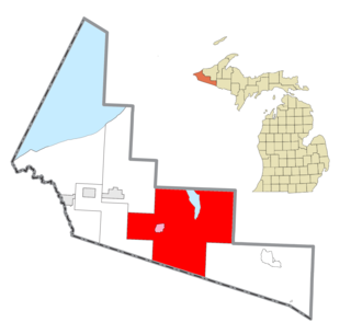
Clark Township is a civil township of Mackinac County in the U.S. state of Michigan. As of the 2020 census, the population was 1,917, down from 2,256 in 2010.

<span class="mw-page-title-main">Garfield Township, Mackinac County, Michigan</span> Civil township in Michigan, United States

Garfield Township is a civil township of Mackinac County in the U.S. state of Michigan. The population was 1,146 at the 2010 census, and 1,166 in 2020.

<span class="mw-page-title-main">Hendricks Township, Michigan</span> Civil township in Michigan, United States

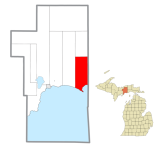
Hendricks Township is a civil township of Mackinac County in the U.S. state of Michigan. The population was 117 at the 2020 census, down from 153 in 2010.

<span class="mw-page-title-main">Hudson Township, Mackinac County, Michigan</span> Civil township in Michigan, United States

Hudson Township is a civil township of Mackinac County in the U.S. state of Michigan. As of the 2020 census, its population was 193.

<span class="mw-page-title-main">Moran Township, Michigan</span> Civil township in Michigan, United States

Moran Township is a civil township of Mackinac County in the U.S. state of Michigan. The population was 1,029 at the 2020 census.

<span class="mw-page-title-main">St. Ignace, Michigan</span> City in Michigan, United States

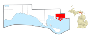
St. Ignace is a city in the U.S. state of Michigan and the county seat of Mackinac County. The city had a population of 2,306 at the 2020 census. St. Ignace Township is located just to the north of the city, but the two are administered autonomously.

<span class="mw-page-title-main">St. Ignace Township, Michigan</span> Civil township in Michigan, United States

St. Ignace Township is a civil township of Mackinac County in the U.S. state of Michigan. As of the 2020 census, the township population was 973.

<span class="mw-page-title-main">Mueller Township, Michigan</span> Civil township in Michigan, United States

Mueller Township is a civil township of Schoolcraft County in the U.S. state of Michigan. The population was 260 in 2020.

<span class="mw-page-title-main">Brevort, Michigan</span> Unincorporated community in Michigan, United States

Brevort is an unincorporated community in Mackinac County in the U.S. state of Michigan. The community is located along the northern shores of Lake Michigan along U.S. Route 2 within Moran Township. As an unincorporated community, Brevort has no legally defined boundaries or population statistics of its own.

<span class="mw-page-title-main">Rapid River, Michigan</span> Census-designated place & unincorporated community in Michigan, United States

Rapid River is an unincorporated community in Masonville Township, Delta County in the U.S. state of Michigan.

<span class="mw-page-title-main">Gould City, Michigan</span> Unincorporated community in Michigan, United States

Gould City is an unincorporated community in Mackinac County in the U.S. state of Michigan. The community is located within Newton Township. As an unincorporated community, Gould City has no legal autonomy of its own but does have its own post office with the 49838 ZIP Code.

<span class="mw-page-title-main">Engadine, Michigan</span> Unincorporated community in Michigan, United States

Engadine is an unincorporated community in Mackinac County in the U.S. state of Michigan. The community is located within Garfield Township. As an unincorporated community, Engadine has no legally defined boundaries or population statistics of its own but does have its own post office with the 49827 ZIP Code.

<span class="mw-page-title-main">Naubinway, Michigan</span> Census-designated place in Michigan, United States

Naubinway is an unincorporated community and census-designated place (CDP) in Mackinac County in the U.S. state of Michigan. The population of the CDP was 147 at the 2020 census, the first year that it was recorded by the census. The community is located within Garfield Township.

<span class="mw-page-title-main">Epoufette, Michigan</span> Unincorporated community in Michigan, United States

Epoufette is an unincorporated community in Mackinac County in the U.S. state of Michigan. The community is located along the northern shores of Lake Michigan along U.S. Route 2 within Hendricks Township. As an unincorporated community, Epoufette has no legally defined boundaries or population statistics of its own.

<span class="mw-page-title-main">Garnet, Michigan</span> Unincorporated community in Michigan, United States

Garnet is an unincorporated community in Mackinac County in the U.S. state of Michigan. The community is located within Hudson Township. As an unincorporated community, Garnet has no legally defined boundaries or population statistics of its own.

References

  1. 1 2 "2022 U.S. Gazetteer Files: Michigan". United States Census Bureau. Retrieved August 15, 2023.
  2. 1 2 "P1. Race – Newton township, Michigan: 2020 DEC Redistricting Data (PL 94-171)". U.S. Census Bureau. Retrieved August 15, 2023.
  3. "U.S. Census website". United States Census Bureau . Retrieved January 31, 2008.
  4. U.S. Geological Survey Geographic Names Information System: Newton Township, Mackinac County, Michigan
  5. Romig, Walter (1986). Michigan Place Names: The History of the Founding and the Naming of More Than Five Thousand Past and Present Michigan Communities. Great Lakes Books Series. Detroit: Wayne State University Press. p. 397. ISBN   978-0-8143-1838-6.
  6. "Feature Detail Report for: Milakokia Lake". USGNIS. U.S. Department of the Interior. Retrieved November 24, 2020.
  7. Romig (1986) , p. 84.
  8. Romig (1986) , p. 134.
  9. U.S. Geological Survey Geographic Names Information System: Gould City, Michigan
  10. Romig (1986) , p. 230.
  11. Google (December 24, 2021). "49838 ZIP Code map" (Map). Google Maps . Google. Retrieved December 24, 2021.
  12. UnitedStatesZipCodes.org (2021). "ZIP Code 49838: Gould City" . Retrieved December 24, 2021.
  13. Romig (1986) , p. 516.
  14. U.S. Geological Survey Geographic Names Information System: Simmons, Michigan
  15. "Explore Census Data". data.census.gov. Retrieved August 4, 2023.
  16. "ST. IGNACE-SAULT STE. MARIE-IRONWOOD" (PDF). Indian Trails. January 15, 2013. Archived from the original (PDF) on July 4, 2014. Retrieved February 28, 2013.