
The Upper Peninsulaof Michigan—also known as Upper Michigan or colloquially the U.P.—is the northern and more elevated of the two major landmasses that make up the U.S. state of Michigan; it is separated from the Lower Peninsula by the Straits of Mackinac. It is bounded primarily by Lake Superior to the north, separated from the Canadian province of Ontario at the east end by the St. Marys River, and flanked by Lake Huron and Lake Michigan along much of its south. Although the peninsula extends as a geographic feature into the state of Wisconsin, the state boundary follows the Montreal and Menominee rivers and a line connecting them.

Mackinac Island is an island and resort area, covering 4.35 square miles (11.3 km2) in land area, in the U.S. state of Michigan. The name of the island in Odawa is Michilimackinac and "Mitchimakinak" in Ojibwemowin meaning "Great Turtle". It is located in Lake Huron, at the eastern end of the Straits of Mackinac, between the state's Upper and Lower Peninsulas. The island was long home to an Odawa settlement and previous indigenous cultures before European colonization began in the 17th century. It was a strategic center of the fur trade around the Great Lakes. Based on a former trading post, Fort Mackinac was constructed on the island by the British during the American Revolutionary War. It was the site of two battles during the War of 1812 before the northern border was settled and the US gained this island in its territory.

Mackinac County is a county in the Upper Peninsula of the U.S. state of Michigan. As of the 2020 census, the population was 10,834. The county seat is St. Ignace. Formerly known as Michilimackinac County, in 1818 it was one of the first counties of the Michigan Territory, as it had long been a center of French and British colonial fur trading, a Catholic church and Protestant mission, and associated settlement.

Emmet County is a county located in the U.S. state of Michigan. It is the northernmost county in the Lower Peninsula. As of the 2020 Census, the population was 34,112, making it the second-most populous county in Northern Michigan. The county seat is Petoskey, which is also the county's largest city.

Cheboygan County is a county in the U.S. state of Michigan. As of the 2020 Census, the population was 25,579. The county seat is Cheboygan. The county boundaries were set off in 1840, with land partitioned from Michilimackinac County. The Cheboygan County government was organized and combined with the former Wyandot County in 1853.

Benton Township is a civil township of Cheboygan County in the U.S. state of Michigan. As of the 2010 census, the township population was 3,206.
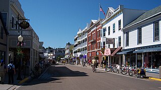
Mackinac Island is a city in Mackinac County in the U.S. state of Michigan. As of the 2020 census, the city had a population of 583.

Mackinaw City is a village at the northernmost point of the Lower Peninsula of Michigan. Divided between Cheboygan and Emmet counties, Mackinaw City is the located at the southern end of the Mackinac Bridge, which carries Interstate 75 over the Straits of Mackinac to the Upper Peninsula. Mackinaw City, along with St. Ignace, serves as an access point to Mackinac Island. For these reasons, Mackinaw City is considered one of Michigan's most popular tourist attractions.

The Territory of Michigan was an organized incorporated territory of the United States that existed from June 30, 1805, until January 26, 1837, when the final extent of the territory was admitted to the Union as the State of Michigan. Detroit was the territorial capital.
Mackinac or Mackinaw may refer to:

The Straits of Mackinac are the short waterways between the U.S. state of Michigan's Upper and Lower Peninsulas, traversed by the Mackinac Bridge. The main strait is 3+1⁄2 miles wide with a maximum depth of 295 feet, and connects the Great Lakes of Lake Michigan and Lake Huron. Given the large size and configuration of the straits, hydrologically, the two connected lakes are one body of water, studied as Lake Michigan–Huron. Historically, the native Odawa people called the region around the Straits Michilimackinac.

Fort Michilimackinac was an 18th-century French, and later British, fort and trading post at the Straits of Mackinac; it was built on the northern tip of the lower peninsula of the present-day state of Michigan in the United States. Built around 1715, and abandoned in 1783, it was located along the Straits, which connect Lake Huron and Lake Michigan of the Great Lakes of North America.
Michilimackinac is derived from an Ottawa Ojibwe name for present-day Mackinac Island and the region around the Straits of Mackinac between Lake Huron and Lake Michigan. Early settlers of North America applied the term to the entire region along Lakes Huron, Michigan, and Superior. Today it is considered to be mostly within the boundaries of Michigan, in the United States. Michilimackinac was the original name for present day Mackinac Island and Mackinac County.

Northern Michigan, also known as Northern Lower Michigan, is a region of the U.S. state of Michigan. A popular tourist destination, it is home to several small- to medium-sized cities, extensive state and national forests, lakes and rivers, and a large portion of Great Lakes shoreline. The region has a significant seasonal population much like other regions that depend on tourism as their main industry. Northern Lower Michigan is distinct from the more northerly Upper Peninsula and Isle Royale, which are also located in "northern" Michigan. In the northernmost 21 counties in the Lower Peninsula of Michigan, the total population of the region is 506,658 people.

Old Mackinac Point Light is a deactivated lighthouse located at the northern tip of the Lower Peninsula in the U.S. state of Michigan. The lighthouse is part of Fort Michilimackinac State Park in the village of Mackinaw City just east of the Mackinac Bridge.
Caledonia was a British brig which saw service on the Great Lakes during the War of 1812. Caledonia was built in Malden in Upper Canada for the North West Company, and launched in 1807. During the early part of the War, the vessel was commandeered by the Provincial Marine, and played an important part in the Siege of Fort Mackinac, carrying troops and guns to the island.
Duncan Township was a civil township in Cheboygan County in the U.S. state of Michigan. It was created on January 29, 1853, and organized on August 23, 1854. As the second township in the county, it consisted of all parts east of the Cheboygan River. Portions of this township were later incorporated into Benton Township in 1871, and Grant Township in 1879. The remnants of Duncan Township were combined with and incorporated into Benton Township on March 7, 1887.
Cusino Township was a civil township in Schoolcraft County in the U.S. state of Michigan. It was first established on March 7, 1907. It was combined with and incorporated into Hiawatha Township on April 16, 1913.

Wyandot County was a county in the U.S. state of Michigan. It was created on April 1, 1840 from part of Michilimackinac County. Wyandot became part of Cheboygan County when it organized on January 29, 1853.


