Clark Township, Michigan | |
|---|---|
 Clark Township Community Center | |
 Location within Mackinac County | |
 Clark Township Location within the state of Michigan  Clark Township Location within the United States | |
| Coordinates: 45°59′57″N84°20′41″W / 45.99917°N 84.34472°W | |
| Country | United States |
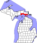
| State | Michigan |
| County | Mackinac |
| Established | 1905 |
| Government | |
| • Supervisor | Mark Clymer |
| • Clerk | Susan Rutledge |
| Area | |
• Total | 101.60 sq mi (263.14 km2) |
| • Land | 78.97 sq mi (204.53 km2) |
| • Water | 22.63 sq mi (58.61 km2) |
| Elevation | 673 ft (205 m) |
| Population | |
• Total | 1,917 |
| • Density | 26.0/sq mi (10.0/km2) |
| Time zone | UTC-5 (Eastern (EST)) |
| • Summer (DST) | UTC-4 (EDT) |
| ZIP Code(s) | 49719 (Cedarville) 49745 (Hessel) |
| Area code | 906 |
| FIPS code | 26-097-16060 [3] |
| GNIS feature ID | 1626088 [4] |
| Website | Official website |
Clark Township is a civil township of Mackinac County in the U.S. state of Michigan. The population was 1,917 at the 2020 census. [2]