Lake Michigan is one of the five Great Lakes of North America. It is the second-largest of the Great Lakes by volume and the third-largest by surface area, after Lake Superior and Lake Huron. To the east, its basin is conjoined with that of Lake Huron through the 3+1⁄2-mile (5.6-kilometer) wide, 295-foot deep Straits of Mackinac, giving it the same surface elevation as its easterly counterpart; the two are geologically a single lake.

Hiawatha National Forest is a 894,836-acre (362,127 ha) National Forest in the Upper Peninsula of the state of Michigan in the United States. Commercial logging is conducted in some areas. The United States Forest Service administers this National Forest; it is physically divided into two subunits, commonly called the Eastside 46°14′N84°50′W and Westside 46°08′N86°40′W.
Mackinac or Mackinaw may refer to:

The Straits of Mackinac are the short waterways between the U.S. state of Michigan's Upper and Lower Peninsulas, traversed by the Mackinac Bridge. The main strait is 3+1⁄2 miles wide with a maximum depth of 295 feet, and connects the Great Lakes of Lake Michigan and Lake Huron. Given the large size and configuration of the straits, hydrologically, the two connected lakes are one body of water, studied as Lake Michigan–Huron. Historically, the native Odawa people called the region around the Straits Michilimackinac.

South Manitou Island is located in Lake Michigan, approximately 16 miles (26 km) west of Leland, Michigan. It is part of Leelanau County and the Sleeping Bear Dunes National Lakeshore. The uninhabited island is 8.277 sq mi (21.44 km2) in land area and can be accessed by a ferry service from Leland. Guided tours on open-air vehicles are available to visitors, but most traffic is on foot. Larger North Manitou Island lies to its north.
The Apostle Islands National Lakeshore is a U.S. national lakeshore consisting of 21 islands and shoreline encompassing 69,372 acres (28,074 ha) on the northern tip of Wisconsin on the shore of Lake Superior. It is known for its collection of historic lighthouses, sandstone sea caves, a few old-growth remnant forests, and natural animal habitats. It is featured on the America the Beautiful Quarters series.

Northern Michigan, also known as Northern Lower Michigan, is a region of the U.S. state of Michigan. A popular tourist destination, it is home to several small- to medium-sized cities, extensive state and national forests, lakes and rivers, and a large portion of Great Lakes shoreline. The region has a significant seasonal population much like other regions that depend on tourism as their main industry. Northern Lower Michigan is distinct from the more northerly Upper Peninsula and Isle Royale, which are also located in "northern" Michigan. In the northernmost 21 counties in the Lower Peninsula of Michigan, the total population of the region is 506,658 people.
The buildings of the St Helena Light complex are the sole surviving structures on St. Helena Island, in Mackinac County in the U.S. state of Michigan. The lighthouse on the St. Helena Island's southeastern point was built in 1872-1873 and went into operation in September 1873. It became one of a series of lighthouses that guided vessels through the Straits of Mackinac, past a dangerous shoal that extends from the island.
St. Helena Island is an uninhabited 240 acres (97 ha) island in the Lake Michigan approach to the Straits of Mackinac. The island is located offshore from Gros Cap, Michigan, 10 miles (16 km) west of Mackinac Island in Mackinac County in the U.S. state of Michigan.

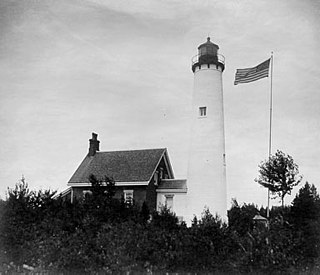
Old Mackinac Point Light is a deactivated lighthouse located at the northern tip of the Lower Peninsula in the U.S. state of Michigan. The lighthouse is part of Fort Michilimackinac State Park in the village of Mackinaw City just east of the Mackinac Bridge.
The Straits of Mackinac Shipwreck Preserve is a 148-square-mile (380 km2) state preserve in and around the Straits of Mackinac. The preserve is divided in two by the Mackinac Bridge. The waters of the preserve include the waters offshore from Mackinaw City and St. Ignace, as well as all or part of the shorelines of Bois Blanc Island, Mackinac Island, Round Island, and St. Helena Island.

For the lighthouse of the same name in the St. Mary's River, see Round Island Light

South Manitou Island Lighthouse is located on South Manitou Island in Lake Michigan, 16 miles (26 km) west of Leland, Michigan. It is in Leelanau County in western Northern Michigan.
The Round Island Channel is a navigable Lake Huron waterway located between Mackinac Island and Round Island in the Straits of Mackinac. It forms a key link in the lake freighter route between Lake Superior and Lake Michigan, on which millions of tons of taconite iron ore are shipped annually. The channel also provides access to the harbor of Mackinac Island, Michigan, and is used by commercial ferryboats delivering passengers to the small island city.

Poe Reef is a lighthouse located at the east end of South Channel between Bois Blanc Island and the mainland of the Lower Peninsula, about 6 miles (9.7 km) east of Cheboygan, Michigan.

The ruined lighthouse at Waugoshance protects boats from a shoal area at the northern end of Lake Michigan. The lighthouse is located in Emmet County, Michigan, United States, and in U.S. Coast Guard District No. 9. It is approximately 15 miles (24 km) west of Mackinaw City. Due to erosion and deterioration, the lighthouse is deteriorating and critically endangered, and likely to fall into the lake in the near future.

The Seul Choix Light is a lighthouse located in the northwest corner of Lake Michigan in Schoolcraft County, Michigan. The station was established in 1892 with a temporary light, and this light started service in 1895, and was fully automated in 1972. It is an active aid to navigation. There is now a museum at the light and both the building and the grounds are open for visitors from Memorial Day until the middle of October.

Beckwith Island is the eastern of three islands in southeastern Georgian Bay in Ontario, Canada. Beckwith Island and the attached "Little Beckwith" are part of the Beausoleil First Nation.

Round Island Passage Light is an automated, unmanned lighthouse located in the Round Island Channel in the Straits of Mackinac, Michigan. The channel is a branch of Lake Huron.

Waugoshance Point is a 2.5-mile-long (4.0 km) cape or peninsula that juts into Lake Michigan from the northwest coast of the Lower Peninsula of the U.S. state of Michigan in Emmet County. It separates the Straits of Mackinac to its north from Sturgeon Bay to the south and is part of Wilderness State Park. The nearest town is Mackinaw City. Waugoshance is a hybrid word, that combines the Anishinaabemowin word wah'goosh and the French word anse.