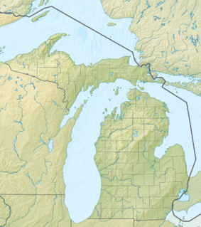
Sleeping Bear Dunes National Lakeshore is a United States National Lakeshore located along the northwest coast of the Lower Peninsula of Michigan in Leelanau and Benzie counties near Empire, Michigan. The park covers a 35-mile-long (56 km) stretch of Lake Michigan's eastern coastline, as well as North and South Manitou islands. This Northern Michigan park was established primarily because of its outstanding natural features, including forests, beaches, dune formations, and ancient glacial phenomena. The lakeshore also contains many cultural features including the 1871 South Manitou Island Lighthouse, three former stations of the Coast Guard and an extensive rural historic farm district. In 2011, the area won the title of "The Most Beautiful Place in America" from Good Morning America. In 2014, a section of the park was named the Sleeping Bear Dunes Wilderness by the United States Congress.

North Manitou Island is located in Lake Michigan, approximately 12 miles (19 km) west-northwest of Leland, Michigan. It is nearly eight miles long and more than four miles (6 km) wide, with 20 miles (32 km) of shoreline. It has a land area of 57.876 km2 and has no population. The smaller South Manitou Island lies to its southwest.
South Manitou Island is located in Lake Michigan, approximately 16 miles (26 km) west of Leland, Michigan. It is part of Leelanau County and the Sleeping Bear Dunes National Lakeshore. The uninhabited island is 8.277 sq mi (21.44 km2) in land area and can be accessed by a ferry service from Leland. Guided tours on open-air vehicles are available to visitors, but most traffic is on foot. Larger North Manitou Island lies to its north.

Pictured Rocks National Lakeshore is a U.S. National Lakeshore in the Upper Peninsula of Michigan, United States. It extends for 42 miles (67 km) along the shore of Lake Superior and covers 73,236 acres. The park has extensive views of the hilly shoreline between Munising and Grand Marais in Alger County, Michigan, with picturesque rock formations, waterfalls, and sand dunes.
The Apostle Islands National Lakeshore is a U.S. national lakeshore consisting of 21 islands and shoreline encompassing 69,372 acres (28,074 ha) on the northern tip of Wisconsin on the shore of Lake Superior. It is known for its collection of historic lighthouses, sandstone sea caves, a few old-growth remnant forests, and natural animal habitats. It is featured on the America the Beautiful Quarters series.

The Apostle Islands are a group of 22 islands in Lake Superior, off the Bayfield Peninsula in northern Wisconsin. The majority of the islands are located in Ashland County—only Sand, York, Eagle, and Raspberry Islands are located in Bayfield County. All the islands except for Madeline Island are part of the Apostle Islands National Lakeshore. The islands in Ashland County are all in the Town of La Pointe, except for Long Island, which is in the Town of Sanborn, while those in Bayfield County are in the Towns of Russell and Bayfield.
The protected areas of Michigan come in an array of different types and levels of protection. Michigan has five units of the National Park Service system. There are 14 federal wilderness areas; the majority of these are also tribal-designated wildernesses. It has one of the largest state forest systems as well having four national forests. The state maintains a large state park system and there are also regional parks, and county, township and city parks. Still other parks on land and in the Great Lakes are maintained by other governmental bodies. Private protected areas also exist in the state, mainly lands owned by land conservancies.
M-209 was a state trunkline highway in the Lower Peninsula of the US state of Michigan. It was located in Leelanau County in the Sleeping Bear Dunes National Lakeshore. Until it was decommissioned, it was Michigan's shortest state highway. M-209 started at M-109 and went just over 1⁄2 mile to Glen Haven. In 1996, M-209's designation was "abandoned", and the road was turned over to the jurisdiction of the Leelanau County Road Commission.

The following is a list of Registered Historic Places in Keweenaw County, Michigan.

Michigan Underwater Preserves or Michigan Bottomland Preserves are protected areas of the Great Lakes on Michigan's coast. The thirteen designated areas, comprising a surface area of over 7,000 square miles (18,000 km2), are considered to be "Underwater museums" and serve to protect concentrations of shipwrecks, unique geologic features and other submerged sites through awareness and public interest. The program is currently receiving no funding from the state and does not offer any extra legal protection for the sites in the preserves. However, it is a felony to remove or disturb underwater artifacts in the Great Lakes. Persons apprehended and convicted of removing or willfully damaging underwater artifacts risk confiscation of their equipment, stiff fines and up to two years imprisonment. The Michigan Underwater Preserve Council advocates on behalf of all of Michigan's Underwater Preserves.

Manitou, akin to the Iroquois orenda, is the spiritual and fundamental life force among Algonquian groups in the Native American theology. It is omnipresent and manifests everywhere: organisms, the environment, events, etc. Aashaa monetoo means "good spirit," while otshee monetoo means "bad spirit." When the world was created, the Great Spirit, Aasha Monetoo, gave the land to the indigenous peoples, the Shawnee in particular.

Glen Haven is a restored port village on the shore of Lake Michigan on the Leelanau Peninsula within the now Sleeping Bear Dunes National Lakeshore. Attractions include the Lake Michigan beach, a restored General Store and Blacksmith Shop. The unincorporated community is located in Glen Arbor Township.

South Manitou Island Lighthouse is located on South Manitou Island in Lake Michigan, 16 miles (26 km) west of Leland, Michigan. It is in Leelanau County in western Northern Michigan.

North Manitou Island Lifesaving Station, also known as North Manitou Coast Guard Station, is a complex of buildings located on North Manitou Island, which is part of Sleeping Bear Dunes National Lakeshore in Michigan, in the U.S. The complex was constructed as a life-saving station. It is the only remaining station which was in use during all three periods of lifesaving service history, from the early volunteer period through operation by the United States Life-Saving Service and the United States Coast Guard. It was declared a National Historic Landmark in 1998.
The DeTour Passage Underwater Preserve is a preservation area in the U.S. state of Michigan. Located in Lake Huron, it completely surrounds Drummond Island and includes all of DeTour Passage and adjacent sections of Lake Huron and the St. Mary's River.
The Alger Underwater Preserve is a preservation area in the U.S. state of Michigan. Located in Lake Superior, it protects waters that lie offshore the Pictured Rocks National Lakeshore and the Grand Island National Recreation Area.

The Gull Rock Light Station is an active lighthouse located on Gull Rock, just west of Manitou Island, off the tip of Michigan's Keweenaw Peninsula in Lake Superior. The light was listed on the National Register of Historic Places in 1984, even as its condition deteriorated, resulting in its placement on the Lighthouse Digest Doomsday List.
Manitou Passage is a navigable Lake Michigan waterway separating North and South Manitou Island from mainland Michigan. The passage—used by deep-draft lake freighters—is located in Leelanau County and is within the Manitou Passage Underwater Preserve.