
Van Buren State Park is a 400-acre (1.6 km2) state park on Lake Michigan south of South Haven, Michigan, United States. The park, which is maintained and operated by the Michigan Department of Natural Resources, is located in the southwest corner of South Haven Township and the northwest corner of Covert Township, just north of the Palisades Nuclear Power Plant.

Indiana Dunes State Park is an Indiana State Park located in Porter County, Indiana, United States, 47 miles (75.6 km) east of Chicago. The park is bounded by Lake Michigan to the northwest, and is surrounded on all four sides by Indiana Dunes National Park, a unit of the National Park Service; the national park owns the water from the ordinary high water mark to 300 feet (91 m) offshore. The 1,530-acre (619.2 ha) Dunes Nature Preserve makes up the bulk of eastern part of the park, and includes most of the park’s hiking trails and dune landscape. This was one of the first places Richard Lieber considered when establishing the Indiana State Park system. Like all Indiana state parks, there is a fee for entrance. Indiana Dunes State Park was established in 1925 and designated a National Natural Landmark in 1974.

Fayette Historic State Park is the state park of the historic town of Fayette in the U.S. state of Michigan. It is located on the Big Bay de Noc of Lake Michigan, between Snail Shell Harbor and Sand Bay, on the southern side of the Upper Peninsula, about 17 miles south of US 2. Fayette was the site of an industrial community that manufactured charcoal pig iron between 1867 and 1891. The town has been reconstructed into a living museum, showing what life was like in this town in the late 19th century. It was listed on the National Register of Historic Places in 1970.

P.J. Hoffmaster State Park is a public recreation area on the shores of Lake Michigan located five miles north of Grand Haven at the southwest corner of Norton Shores, in Muskegon County, and the northwest corner of Spring Lake Township, in Ottawa County, in the U.S. state of Michigan. It is operated by the Michigan Department of Natural Resources. The state park includes 1,200 acres (490 ha) of land including 3 miles (5 km) of sand beach on the lake. The park is named after P.J. Hoffmaster, sometimes considered the founder of the Michigan state parks system, who served as the Superintendent of State Parks and Director of the Department of Conservation. The park's nature center is named for Emma Genevieve Gillette, who scouted locations for new state parks under Hoffmaster.

Muskegon State Park is a public recreation area located four miles (6.4 km) west of North Muskegon in Muskegon County, Michigan. The park's 1,233 acres (499 ha) encompass two miles of sand beach on Lake Michigan and one mile of beach on Muskegon Lake.

Warren Woods is a 311-acre (1.26 km2) state park in Berrien County, Michigan, near the town of Three Oaks. It is leased by private owners to the state of Michigan.
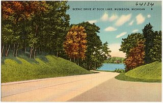
Duck Lake State Park is a public recreation area covering 728 acres (295 ha) along Lake Michigan five miles (8.0 km) southwest of Whitehall in Muskegon County, Michigan. The state park, which runs along the north side of Duck Lake to Lake Michigan, features a large sand dune. The park's Scenic Drive is part of the Shoreline Trail route in Muskegon County.

Holland State Park is a public recreation area covering 142 acres (57 ha) in Park Township, Ottawa County, four miles (6 km) west of the city of Holland, Michigan. The state park consists of separate Lake Macatawa and Lake Michigan units on the northern side of the channel connecting Lake Macatawa with Lake Michigan. It is often the most visited state park in Michigan, receiving between 1.5 and 2 million visitors annually.

Wilderness State Park is a public recreation area bordering Lake Michigan, five miles southwest of Mackinaw City in Emmet County in Northern Michigan. The state park's 10,512 acres (4,254 ha) include 26 miles (42 km) of shoreline, diverse forested dune and swale complexes, wetlands, camping areas, and many miles of hiking trails. The state park is operated by the Michigan Department of Natural Resources, which has, as of 2006, approved a proposal that 4,492 acres (1,818 ha) be officially dedicated as a wilderness area. Wilderness State Park was designated a Michigan "dark sky preserve" in 2012.

Fisherman's Island State Park is public recreation area of 2,678 acres (1,084 ha) sitting on six miles (9.7 km) of the Lake Michigan shoreline southwest of Charlevoix, Michigan. Due to historically low lake levels, for most of 1998 to 2016 the small Fisherman Island, for which the state park was named, had become attached to the mainland via a tombolo.

Grand Mere State Park is a public recreation and nature preservation area in the southwestern part of the U.S. state of Michigan near Stevensville. The state park is located adjacent to Interstate 94. Protected from Lake Michigan by the dunes to the west, the park has many natural features not found throughout the rest of the state. In 1968 it was designated a National Natural Landmark.

Charles Mears State Park is a public recreation area covering 50 acres (20 ha) in the village of Pentwater, Oceana County, Michigan. The state park sits on Lake Michigan, directly north of a channel that leads into Pentwater Lake. The park land, which was once owned by lumber baron Charles Mears, was donated to the state by his daughter Carrie Mears in 1923. The park offers fishing, swimming, camping, picnicking, and a one-mile hiking trail that ascends the Old Baldy sand dune.

Petoskey State Park is a public recreation area covering 303 acres (123 ha) on Lake Michigan in Bear Creek Township, Emmet County, Michigan. The state park is located 3 miles (4.8 km) northeast of the city of Petoskey on Little Traverse Bay. It is surrounded by heavily vegetated sand dunes that are excellent examples of parabolic dunes. Michigan's state stone, the Petoskey stone, can be found on the park beach.

Port Crescent State Park is a public recreation area on Lake Huron five miles (8.0 km) southwest of Port Austin in Huron County at the tip of The Thumb of Michigan. The state park covers 640 acres (260 ha) along state route M-25 in Hume Township. The park occupies the site of Port Crescent, a ghost town which once stood at the mouth of the Pinnebog River. The park was designated a Michigan "dark sky preserve" in 2012.
Silver Lake State Park is a public recreation area covering 2,936 acres (1,188 ha) bordering Lake Michigan and Silver Lake near Mears in Oceana County, Michigan. The state park is composed of mature forest land and over 2,000 acres (810 ha) of sand dunes. The park is 1.5 miles (2.4 km) wide and 3 miles (4.8 km) long and is divided into three segments: The northern area is an all-terrain vehicle dunes area where private motorized vehicle may be driven, the middle of the park is a non-vehicle area, and the southernmost section is leased to a private operator. The park grounds include the Little Sable Point Light on Lake Michigan and one mile of shoreline on 690-acre (280 ha) Silver Lake.

Pinckney State Recreation Area is a Michigan state recreation area in Dexter, Sylvan and Lyndon Townships, Washtenaw County and Putnam and Unadilla Townships, Livingston County in the U.S. state of Michigan. The park is 11,000 acres (4,500 ha) and sits at an elevation of 922 feet (281 m). The park is connected to the nearby Waterloo State Recreation Area by the 35-mile (56 km) Waterloo–Pinckney Trail. Pinckney State Recreation Area is open for year-round recreation including hiking, fishing, swimming, hunting and a variety of winter sports.

The Felt Mansion is a house located at 66th Street and 138th Avenue, in Laketown Township, Michigan near Saugatuck, Michigan. It was listed on the National Register of Historic Places in 1996.

