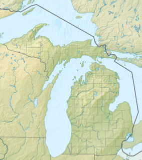
The Great Lakes, also called the Great Lakes of North America, are a series of large interconnected freshwater lakes in the upper mid-east region of North America that connect to the Atlantic Ocean via the Saint Lawrence River. They are lakes Superior, Michigan, Huron, Erie, and Ontario and are in general on or near the Canada–United States border. Hydrologically, there are four lakes, because lakes Michigan and Huron join at the Straits of Mackinac. The Great Lakes Waterway enables travel by water between the lakes.

Lake Michigan is one of the five Great Lakes of North America. It is the second-largest of the Great Lakes by volume (1,180 cu mi and the third-largest by surface area (22,404 sq mi, after Lake Superior and Lake Huron. To the east, its basin is conjoined with that of Lake Huron through the narrow Straits of Mackinac, giving it the same surface elevation as its easterly counterpart; the two are technically a single lake.
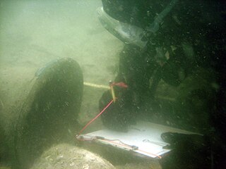
Maritime archaeology is a discipline within archaeology as a whole that specifically studies human interaction with the sea, lakes and rivers through the study of associated physical remains, be they vessels, shore-side facilities, port-related structures, cargoes, human remains and submerged landscapes. A specialty within maritime archaeology is nautical archaeology, which studies ship construction and use.

Lake Huron is one of the five Great Lakes of North America. Hydrologically, it comprises the easterly portion of Lake Michigan–Huron, having the same surface elevation as its westerly counterpart, to which it is connected by the 5-mile-wide (8.0 km), 20-fathom-deep Straits of Mackinac. It is shared on the north and east by the Canadian province of Ontario and on the south and west by the state of Michigan in the United States. The name of the lake is derived from early French explorers who named it for the Huron people inhabiting the region. The Huronian glaciation was named due to evidence collected from Lake Huron region. The northern parts of the lake include the North Channel and Georgian Bay. Across the lake to the southwest is Saginaw Bay. The main inlet is the St. Marys River, and the main outlet is the St. Clair River.

Drummond Island Township is a civil township of Chippewa County in the U.S. state of Michigan. The population was 1,058 at the 2010 census.

Georgian Bay is a large bay of Lake Huron, in the Laurentia bioregion. It is located entirely within the borders of Ontario, Canada. The main body of the bay lies east of the Bruce Peninsula and Manitoulin Island. To its northwest is the North Channel.

South Manitou Island is located in Lake Michigan, approximately 16 miles (26 km) west of Leland, Michigan. It is part of Leelanau County and the Sleeping Bear Dunes National Lakeshore. The uninhabited island is 8.277 sq mi (21.44 km2) in land area and can be accessed by a ferry service from Leland. Guided tours on open-air vehicles are available to visitors, but most traffic is on foot. Larger North Manitou Island lies to its north.
The Thumb is a region and a peninsula of the U.S. state of Michigan, so named because the Lower Peninsula is shaped like a mitten. The Thumb area is generally considered to be in the Central Michigan region, east of the Tri-Cities and north of Metro Detroit. The region is also branded as the Blue Water Area.

The Marquette Underwater Preserve was established in 1990 to promote conservation of the submerged historical resources in Lake Superior near Marquette, Michigan. The Preserve is composed of two separate units, the Marquette Unit and the Huron Islands Unit. The Marquette Unit extends along approximately 24 miles of Michigan shoreline out to the 200-foot depth contour. The Huron Islands Unit surrounds a group of granite peaks about 12 miles from shore. The Michigan Underwater Preserve Council oversees activities relating to all of Michigan's Underwater Preserves.
Thunder Bay National Marine Sanctuary and Underwater Preserve is a United States National Marine Sanctuary on Lake Huron's Thunder Bay, within the northeastern region of the U.S. state of Michigan. It protects an estimated 116 historically significant shipwrecks ranging from nineteenth-century wooden side-wheelers to twentieth-century steel-hulled steamers. There are a great many wrecks in the sanctuary, and their preservation and protection is a concern for national policymakers. The landward boundary of the sanctuary extends from the western boundary of Presque Isle County to the southern boundary of Alcona County. The sanctuary extends east from the lakeshore to the international border. Alpena is the largest city in the area.
M-134 is an east–west state trunkline highway in the Upper Peninsula (UP) of the US state of Michigan. It connects Interstate 75 (I-75) north of St. Ignace with the communities of Hessel, Cedarville and De Tour Village along Lake Huron. East of De Tour, the highway crosses the De Tour Passage on a ferry to run south of the community of Drummond on Drummond Island. It is one of only three state trunklines in Michigan on islands; the others are M-154 on Harsens Island and M-185 on Mackinac Island. M-134 is also one of only two highways to utilize a ferry in Michigan; the other is US Highway 10 (US 10) which crosses Lake Michigan from Manitowoc, Wisconsin, to Ludington. Most of the mainland portion of M-134 is also part of the Lake Huron Circle Tour, and since 2015, it has been a Pure Michigan Byway under the name M-134 North Huron Byway.
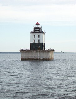
The DeTour Reef Light is a non-profit-operated lighthouse marking the southern entrance of the DeTour Passage between the eastern end of Michigan's Upper Peninsula and Drummond Island. The light is an automated active aid to navigation. It marks the northern end of Lake Huron. The passage is used by almost all of the Great Lakes commercial freighter traffic moving to and from Lake Superior, with approximately 5,000 vessel movements annually. It is said to be "the gateway to Lake Superior." In addition, many recreational boaters use the passage. The Light is located in Lake Huron, three miles (5 km) south of the nearest town, DeTour Village, Michigan.
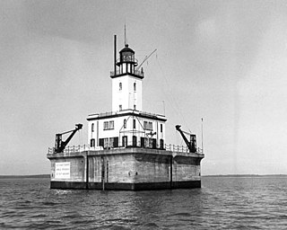
Poe Reef is a lighthouse located at the east end of South Channel between Bois Blanc Island and the mainland of the Lower Peninsula, about 6 miles (9.7 km) east of Cheboygan, Michigan.

The Whitefish Point Underwater Preserve was established in 1987 to protect and conserve shipwrecks and historical resources on 376 square miles (970 km2) of Lake Superior bottomlands in Whitefish Bay and around Whitefish Point, Michigan. The formation of the Michigan Underwater Preserves helped stop controversy over artifact removal from shipwrecks of this area. The preserve is now known for deep, well preserved shipwrecks in clear water accessible to scuba divers with technical skill and experience. The preserve is one of the last places in the Great Lakes to observe shipwrecks without zebra mussel encrustation.
The Manitou Passage Underwater Preserve is a preservation area in the U.S. state of Michigan. Located in Lake Michigan, it completely surrounds North Manitou Island and South Manitou Island. It includes much of that portion of Lake Michigan that borders the federally protected Sleeping Bear Dunes National Lakeshore.
The Alger Underwater Preserve is a preservation area in the U.S. state of Michigan. Located in Lake Superior, it protects waters that lie offshore the Pictured Rocks National Lakeshore and the Grand Island National Recreation Area.

Round Island Passage Light is an automated, unmanned 1948 lighthouse located in the Round Island Channel in the Straits of Mackinac, Michigan. The channel is a branch of Lake Huron.
The Grand Traverse Bay Underwater Preserve is a preservation area that encompasses all of Grand Traverse Bay, a bay of Lake Michigan, in the U.S. state of Michigan. It is 295 square miles (760 km2) in size and is located off Traverse City, Michigan.
Potagannissing Bay is a shallow, island-strewn bay on Lake Huron in Algoma District, Ontario, Canada and Chippewa County, Michigan, United States. It is bounded by the land masses of St. Joseph Island, Ontario at the northwest and Drummond Island, Michigan at the southeast, and by the water bodies the Saint Marys River and the De Tour Passage at the southwest and the North Channel at the northeast. The bay is northeast of De Tour Village, Chippewa County. The bay's waters are rich in freshwater fish.
Save Ontario Shipwrecks (SOS) is a Provincial Heritage Organization in Ontario, Canada. SOS is a public charitable organization which operates through Local Chapter Committees supported by a Provincial Board of Directors and Provincial Executive.