
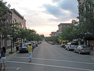
Cadillac is a city in and county seat of Wexford County in the U.S. state of Michigan. The population was 10,371 at the 2020 census, making it the second most-populated city in the Northern Michigan region, after Traverse City.
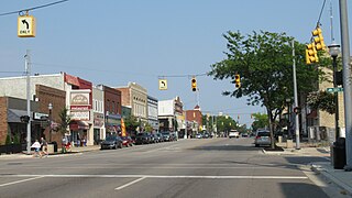
Petoskey is the largest city and the county seat of Emmet County, Michigan, and is the largest settlement within the county. Petoskey has a population of 5,877 at the 2020 census, up from 5,670 at the 2010 census.
Ludington is a city in the U.S. state of Michigan. It is the county seat and the largest city in Mason County. The population was 7,655 at the 2020 census.

Clare is a city in the U.S. state of Michigan. Located near the center of Michigan's Lower Peninsula, the city is located mostly in Clare County, while a small portion extends south into Isabella County. The city had a population of 3,254 at the 2020 census.

The Huron–Manistee National Forests are two separate national forests, the Huron National Forest and the Manistee National Forest, combined in 1945 for administration purposes and which comprise 978,906 acres (3,960 km2) of public lands, including 5,786 acres (23 km2) of wetlands, extending across the northern lower peninsula of Michigan. The Huron–Manistee National Forests provide recreation opportunities for visitors, habitat for fish and wildlife, and resources for local industry. The headquarters for the forests is in Cadillac, Michigan.

The Fox River is a river in eastern Wisconsin in the Great Lakes region of the United States. It is the principal tributary of the Green Bay, and via the bay, the largest tributary of Lake Michigan. The city of Green Bay, one of the first European settlements in the interior of North America, is on the river at its mouth on the Green Bay.

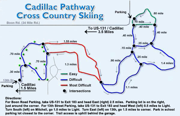
The Manistee National Forest is a national forest located in the Lower Peninsula of Michigan. It has a total area of 540,187 acres (2,190 km2). It was established in 1938, and combined with the Huron National Forest in 1945 for administrative purposes, creating the Huron-Manistee National Forests. However, they are two separate forest units, as they are not connected. The area is popular for hiking, fishing, camping, boating, snowmobiling, cross-country skiing and hunting. The North Country Trail passes through it, and connects with the 11-mile Manistee River Trail to form a 23-mile loop. The highest point in the lower peninsula, Briar Hill (1,706 ft), is located here. The Manistee National Forest is not one continuous mass, but is a "mosaic" broken by private property and towns. The headquarters for the forest is in Cadillac, Michigan.

The Great Lakes Central Railroad is an American shortline railroad, operating in the state of Michigan. It was originally called the Tuscola and Saginaw Bay Railway, which was formed on August 26, 1977, to operate over former Penn Central lines from Millington to Munger, and from Vassar to Colling. TSBY's name was derived from the three counties it operated in: Tuscola, Saginaw and Bay.
Fred Meijer White Pine Trail State Park is a 92-mile (148 km) long linear state park in the U.S. state of Michigan.

Pere Marquette Beach in Muskegon, Michigan is a 27.5-acre (11.1 ha) park comprising 2.5 miles (4.0 km) of public beach on Lake Michigan. In 2004 the beach appeared on lists of certified clean beaches published by the National Healthy Beaches Campaign and the Clean Beaches Council. This city park, located on Lake Michigan, offers a wide expanse of beach, playground, volleyball courts, a restaurant, access to lighthouses and the Muskegon Channel, also the site of the "USS Silversides," a World War II Submarine, and nearby, a full-service restaurant and bar. The beach is also home to the Muskegon Lakeshore Trail, a trail connecting Pere Marquette Beach with Downtown Muskegon, as well as connecting with other northerly trails. The beach is also known for having a very large sand area. Muskegon also has two other beach parks, Harbour Towne Beach and Kruse Park. Kruse Park is the only beach in Muskegon County to allow dogs.

The Pere Marquette Rail-Trail (PMRT) is a rail trail in Michigan occupying a 28-mile (45 km) abandoned CSX railroad corridor in Midland County and Isabella County that was once part of the Flint and Pere Marquette Railroad. In 1874, the tracks stretched from Ludington to Flint, transporting supplies to the timber industry in southern Michigan's mills. It is currently a Michigan Rails to Trails Conservancy Hall of Fame trail.
The Flint and Pere Marquette Railroad (F&PM) is a defunct railroad which operated in the U.S. state of Michigan between 1857 and 1899. It was one of the three companies which merged to become the Pere Marquette Railway.
The Chicago and West Michigan Railway (C&WM) is a defunct railroad which operated in the state of Michigan between 1881 and 1899. It was one of the three companies which merged to become the Pere Marquette Railway.

US Highway 10 (US 10) is a part of the United States Numbered Highway System that runs from West Fargo, North Dakota, to the Lower Peninsula of the US state of Michigan. The highway enters Michigan on SS Badger, which crosses Lake Michigan between Manitowoc, Wisconsin, and Ludington. As the highway crosses the state, it is a two-lane undivided highway between Ludington and Farwell and a freeway from Farwell east to the highway's terminus in Bay City. US 10 runs concurrently with US 127 in the Clare area along a section of freeway that includes a welcome center in the median. Outside of the Clare and Midland areas, US 10 runs through rural areas of West and Central Michigan in a section of the Manistee National Forest as well as farmfields.

The Pere Marquette State Trail is a bicycle and multi-use trail in lower Michigan, running 55 miles (89 km) through Clare, Lake, and Osceola Counties. Intersecting with the White Pine Trail in Reed City, the trail is paved in areas, with a ballast or cinder surface elsewhere. The trail's western terminus is the Village of Baldwin with the City of Clare as its eastern terminus. From Baldwin east to The Pere Marquette State Trail is open to non-motorized uses. Except for a gap at its eastern end as the trail enters the City of Clare, it is developed on a former railroad bed. From the City of Clare southeast to Midland, the trail continues as the Pere Marquette Rail Trail.

Lake is an unincorporated community in Clare County in the U.S. state of Michigan. The community is located within Garfield Township. As an unincorporated community, Lake has no legal autonomy of its own but does have its own post office with the 48632 ZIP Code.
U.S. Bicycle Route 20 (USBR 20) is a U.S. Numbered Bicycle Route that is planned to run from the Oregon Coast to Marine City, Michigan. As of 2021, sections of the route in Washington state and Michigan have been approved by the American Association of State Highway and Transportation Officials (AASHTO), comprising 387 miles (623 km).

SS Pere Marquette 18 was a steel-hulled Great Lakes train ferry that served on Lake Michigan from her construction in 1902 to her sinking in 1910.


