Paint River

Last updated
Paint River
Country United States
State Michigan
Type Recreational
Designated March 3, 1992

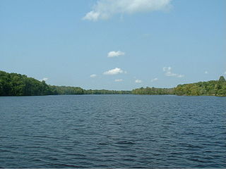
Paint River is a 45.5-mile-long (73.2 km) [1] river in the U.S. state of Michigan.

U.S. state constituent political entity of the United States

In the United States, a state is a constituent political entity, of which there are currently 50. Bound together in a political union, each state holds governmental jurisdiction over a separate and defined geographic territory and shares its sovereignty with the federal government. Due to this shared sovereignty, Americans are citizens both of the federal republic and of the state in which they reside. State citizenship and residency are flexible, and no government approval is required to move between states, except for persons restricted by certain types of court orders. Four states use the term commonwealth rather than state in their full official names.

Michigan State of the United States of America

Michigan is a state in the Great Lakes and Midwestern regions of the United States. The state's name, Michigan, originates from the Ojibwe word mishigamaa, meaning "large water" or "large lake". With a population of about 10 million, Michigan is the tenth most populous of the 50 United States, with the 11th most extensive total area, and is the largest state by total area east of the Mississippi River. Its capital is Lansing, and its largest city is Detroit. Metro Detroit is among the nation's most populous and largest metropolitan economies.

It is a tributary of the Brule River and flows through Gogebic and Iron counties. Via the Brule River, it is part of the Menominee River watershed, flowing to Lake Michigan.

Brule River tributary of the Menominee River in Michigan and Wisconsin, United States

The Brule River is a 52.3-mile-long (84.2 km) river in the U.S. states of Michigan and Wisconsin. Nearly the entire course forms a portion of the boundary between the two states.

Gogebic County, Michigan County in the United States

Gogebic County is the westernmost county in the Upper Peninsula in the U.S. state of Michigan. As of the 2010 census, the population was 16,427. The county seat is Bessemer. This was historically part of the territory of the Lake Superior Band of Chippewa, which had twelve bands in Michigan, Wisconsin and Minnesota. The Lac Vieux Desert Indian Reservation is in this county, in Watersmeet Township, as the land base of one of the federally recognized tribes.

Iron County, Michigan County in the United States

Iron County is a county in the Upper Peninsula of the U.S. state of Michigan. As of the 2010 United States Census, the population was 11,817. The county seat is Crystal Falls.

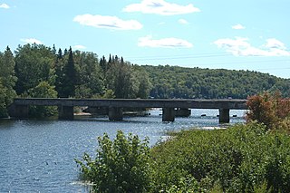
The Paint River flows through Crystal Falls, Michigan, and empties into the Brule River before its confluence with the Michigamme River to form the Menominee.

Crystal Falls, Michigan City in Michigan, United States

Crystal Falls is a city in the U.S. state of Michigan. As of the 2010 census, the city population was 1,469. It is the county seat of Iron County. The city is located within Crystal Falls Township, but is a separate municipal entity. The area first developed as a major center for iron mining and the timber industry; it has become increasingly popular for tourism in recent years.

Michigamme River river in the United States of America

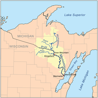
The Michigamme River is a 67.0-mile-long (107.8 km) tributary of the Menominee River on the Upper Peninsula of Michigan in the United States. Via the Menominee River, its water flows to Lake Michigan.

Related Research Articles

Menominee River river in Wisconsin and Michigan

The Menominee River is a river in northwestern Michigan and northeastern Wisconsin in the United States. It is approximately 116 miles (187 km) long, draining a rural forested area of northern Wisconsin and the Upper Peninsula of Michigan into Lake Michigan. Its entire course, with that of its tributary, the Brule River, forms part of the boundary between the two states.

Bark River is a 23.7-mile-long (38.1 km) river on the Upper Peninsula of the U.S. state of Michigan. The river flows into Green Bay on Lake Michigan in Ford River Township about 15 miles (24 km) southwest of Escanaba at 45°34′22″N87°14′34″W.

Wolf River (Fox River tributary) principal tributary of Fox River of Green Bay in eastern Wisconsin

The Wolf River is a 225 mi (362 km) long tributary of the Fox River in northeastern Wisconsin in the Great Lakes region of the United States. The river is one of the two National Scenic Rivers in Wisconsin, along with the St. Croix River. The scenic portion is 24 miles (39 km) long. The river and its parent the Fox River and associated lakes are renown for their sturgeon which spawn every spring upstream on the lower river until blocked by the Shawano Dam. The river flows through mostly undeveloped forestland southerly from central Forest County in the north to Lake Poygan in the south. The lake is part of the Winnebago Pool of lakes fed by both the Fox and Wolf Rivers. The Fox-Wolf basin is usually considered to be a single unified basin and the rivers themselves may be referred to as the Fox-Wolf River system.

Brule Lake forms part of the border between the states of Michigan and Wisconsin and is the headwater of the Brule River at 46°02′23″N88°50′59″W.

Cedar Creek may refer to several small streams in the U.S. state of Michigan:

The Mitchigan River is a 14.9-mile-long (24.0 km) stream in the Upper Peninsula of the U.S. state of Michigan. It flows into the Fence River at 46°17′27″N88°09′58″W in northeast Iron County in Mansfield Township. The Fence River is a tributary of the Michigamme River, which is itself a tributary the Menominee River, flowing to Lake Michigan. The Mitchigan River has its source in the southeast corner of Baraga County at 46°24′58″N88°08′05″W. It flows mostly southward along the boundary between Iron and Marquette counties, crossing briefly into western Marquette County.

The Iron River is a 17.1-mile-long (27.5 km) river in Iron County, Michigan, in the United States. It flows from northwest to southeast through the city of Iron River to the Brule River. It is part of the Menominee River watershed, flowing to Lake Michigan.

The Hemlock River is a 12.9-mile-long (20.8 km) river in Michigan in the United States. It is a tributary of the Paint River, which flows to the Brule River, then the Menominee River, and ultimately Lake Michigan.

The Little Hemlock River is a 7.8-mile-long (12.6 km) river in Michigan. It is a tributary of the Hemlock River, flowing via the Paint River, Brule River, and Menominee River to Lake Michigan.

The Net River is a 14.9-mile-long (24.0 km) river in Michigan in the United States. Its headwaters rise in Baraga County and flow southwest into Iron County, where the main stem forms and flows to the Paint River above Crystal Falls.

The Perch River is a 25.4-mile-long (40.9 km) tributary of the Sturgeon River in Iron County and Baraga County on the Upper Peninsula of Michigan in the United States. The Perch River begins at the outlet of Perch Lake in Bates Township and flows north through Ottawa National Forest to the Sturgeon River.

Peshekee River river in the United States of America

The Peshekee River is a 31.1-mile-long (50.1 km) river on the Upper Peninsula of Michigan in the United States. It is a tributary of Lake Michigamme, and its waters flow via the Michigamme River and the Menominee River to Lake Michigan.

The Shakey River is a 26.2-mile-long (42.2 km) river on the Upper Peninsula of Michigan which flows into the Menominee River, a tributary of Lake Michigan.

The Spruce River is a 9.9-mile-long (15.9 km) tributary of the Michigamme River on the Upper Peninsula of Michigan in the United States. Via the Michigamme River and the Menominee River, it is a tributary of Lake Michigan.

Sturgeon River (Michigan) Wikimedia disambiguation page

Sturgeon River may refer to any of the following streams in the U.S. state of Michigan:

Sandy Run is an unincorporated community in Calhoun County, South Carolina, United States. Its elevation is 154 feet (47 m). Sandy Run is best known for hosting the United States Marine Corps semi-annual Mud Run. Sandy Run is named after a local stream, Sandy Run, which flows through Sandy Run and neighboring communities, Gaston and Swansea which flows into the Congaree River.

Indian River (Manistique River tributary) tributary of the Manistique River on the Upper Peninsula of Michigan in the United States

Indian River is a 59.1-mile-long (95.1 km) tributary of the Manistique River on the Upper Peninsula of Michigan in the United States. It rises out of Hovey Lake at 46°17′36″N86°42′20″W on Hiawatha National Forest land in Alger County and flows south and east through a lake district and on through Schoolcraft County. The river flows into the 8,659 acre (35 km²) Indian Lake at 46°17′36″N86°42′20″W and flows out at 45°59′30″N86°17′15″W. It then flows east and south about 2.5 miles where it merges with the Manistique River, which then flows through Manistique and into Lake Michigan at 45°56′56″N86°14′45″W.

Little Cedar River is a 56.7-mile-long (91.2 km) river in Menominee County in the U.S. state of Michigan.

References

  1. U.S. Geological Survey. National Hydrography Dataset high-resolution flowline data. The National Map, accessed December 19, 2011

Coordinates: 45°57′50″N88°14′42″W / 45.96389°N 88.24500°W / 45.96389; -88.24500

Geographic coordinate system Coordinate system

A geographic coordinate system is a coordinate system that enables every location on Earth to be specified by a set of numbers, letters or symbols. The coordinates are often chosen such that one of the numbers represents a vertical position and two or three of the numbers represent a horizontal position; alternatively, a geographic position may be expressed in a combined three-dimensional Cartesian vector. A common choice of coordinates is latitude, longitude and elevation. To specify a location on a plane requires a map projection.