Brule River

Last updated
Brule River at the M-189-WIS 139 crossing M-189-WI 139 Brule River bridge 3.jpg
Brule River at the M-189WIS 139 crossing

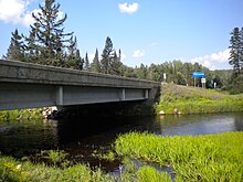
The Brule River is a 52.3-mile-long (84.2 km) [1] river in the U.S. states of Michigan and Wisconsin. Nearly the entire course forms a portion of the boundary between the two states.

U.S. state constituent political entity of the United States

In the United States, a state is a constituent political entity, of which there are currently 50. Bound together in a political union, each state holds governmental jurisdiction over a separate and defined geographic territory and shares its sovereignty with the federal government. Due to this shared sovereignty, Americans are citizens both of the federal republic and of the state in which they reside. State citizenship and residency are flexible, and no government approval is required to move between states, except for persons restricted by certain types of court orders. Four states use the term commonwealth rather than state in their full official names.

Michigan State of the United States of America

Michigan is a state in the Great Lakes and Midwestern regions of the United States. The state's name, Michigan, originates from the Ojibwe word mishigamaa, meaning "large water" or "large lake". With a population of about 10 million, Michigan is the tenth most populous of the 50 United States, with the 11th most extensive total area, and is the largest state by total area east of the Mississippi River. Its capital is Lansing, and its largest city is Detroit. Metro Detroit is among the nation's most populous and largest metropolitan economies.

Wisconsin A north-central state of the United States of America

Wisconsin is a U.S. state located in the north-central United States, in the Midwest and Great Lakes regions. It is bordered by Minnesota to the west, Iowa to the southwest, Illinois to the south, Lake Michigan to the east, Michigan to the northeast, and Lake Superior to the north. Wisconsin is the 23rd largest state by total area and the 20th most populous. The state capital is Madison, and its largest city is Milwaukee, which is located on the western shore of Lake Michigan. The state is divided into 72 counties.

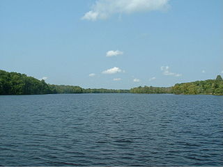
The Brule begins at Brule Lake, just inside the Michigan border, at 46°02′23″N88°50′59″W / 46.03972°N 88.84972°W / 46.03972; -88.84972 . It winds east and southeast until joining with the Michigamme River at 45°57′12″N88°11′46″W / 45.95333°N 88.19611°W / 45.95333; -88.19611 to form the Menominee River and on into Lake Michigan.

Brule Lake forms part of the border between the states of Michigan and Wisconsin and is the headwater of the Brule River at 46°02′23″N88°50′59″W.

Michigamme River river in the United States of America

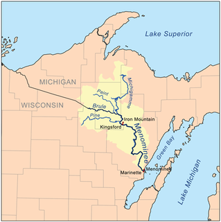
The Michigamme River is a 67.0-mile-long (107.8 km) tributary of the Menominee River on the Upper Peninsula of Michigan in the United States. Via the Menominee River, its water flows to Lake Michigan.

Menominee River river in Wisconsin and Michigan

The Menominee River is a river in northwestern Michigan and northeastern Wisconsin in the United States. It is approximately 116 miles (187 km) long, draining a rural forested area of northern Wisconsin and the Upper Peninsula of Michigan into Lake Michigan. Its entire course, with that of its tributary, the Brule River, forms part of the boundary between the two states.

The Brule River is stocked with many types of trout. These include Brook, and Brown trout[ citation needed ]

The Brule is popular for canoeing, spanning about 45 miles (72 km) with several stop/start points somewhat evenly spread out. The Brule's flow is much more reliable than many other surrounding rivers, due to its "untouched" quality.[ citation needed ] There is only one dam on the river that affects the water level, but that is located on Brule Island near the end of the Brule just below the Paint River.

Paint River is a 45.5-mile-long (73.2 km) river in the U.S. state of Michigan.

Much of the land on both sides of the river is publicly owned with several good campsites available. Fishing is exceptional, with brook and brown trout in the upper areas and tributaries. Smallmouth bass and northern pike can be found in abundance in the lower sections.

Related Research Articles

Au Sable River (Michigan) river in Michigan

The Au Sable River in Michigan, United States runs approximately 138 miles (222 km) through the northern Lower Peninsula, through the towns of Grayling and Mio, and enters Lake Huron at Au Sable. It is considered one of the best brown trout fisheries east of the Rockies and has been designated a blue ribbon trout stream by the Michigan Department of Natural Resources. In French, au sable literally means "at the sand." A 1795 map calls it the Beauais River.

Brule, Wisconsin Town in Wisconsin, United States

Brule is a town in Douglas County, Wisconsin, United States. The population was 591 at the 2000 census. The town takes its name from the nearby Bois Brule River, which flows north into Lake Superior. The census-designated place of Brule and unincorporated communities of Bellwood, Waino, and Winneboujou are located in the town of Brule.

Salmon Trout River river in the United States of America

There are two streams named Salmon Trout River in the Upper Peninsula of the U.S. state of Michigan.

Missisquoi River river

The Missisquoi River is a tributary of Lake Champlain, approximately 80 mi (130 km) long, in northern Vermont in the United States and southern Quebec in Canada. It drains a rural area of the northern Green Mountains along the Canada–US border northeast of Lake Champlain, and an area of Quebec's Eastern Townships. The South Branch rises in Vermont and runs generally from southeast to northwest; the North Branch rises in Lake d'Argent in Eastman, Quebec, and runs from north to south. The North Branch and the South Branch join at Highwater, Quebec, just downriver from North Troy, Vermont. The river then runs in Quebec for approximately 15 miles (24 km), re-entering Vermont at Richford and thence to Lake Champlain's Missisquoi Bay.

Gull Island is the name of a dozen small islands in the U.S. state of Michigan.

Otter Lake (Michigan) list of lakes that share the same name

Otter Lake is the name of several lakes and one village in the U.S. state of Michigan.

Escanaba River river in the United States of America

The Escanaba River is a 52.2-mile-long (84.0 km) river on the Upper Peninsula of the U.S. state of Michigan.

Carp River is a 40.2-mile-long (64.7 km) river in Chippewa and Mackinac counties in the U.S. state of Michigan. 21.7 miles (34.9 km) of the river were added to the National Wild and Scenic Rivers System in 1992.

Elk Lake is located in Antrim and Grand Traverse counties in Northern Michigan. The lake is about a mile and a half wide (2.4 km) and nine miles (14 km) long, and is centered at 44°51′N85°23′W near the town of Elk Rapids. It has maximum depth of 192 ft (59 m), making it Michigan's second deepest after Torch Lake. It is a popular lake for fishing, featuring lake trout, rock bass, yellow perch, smallmouth bass, muskellunge, ciscoes, brown trout, rainbow trout, and whitefish.

The Days River is a 30.1-mile-long (48.4 km) river on the Upper Peninsula of the U.S. state of Michigan.

Trout Creek is a 6.5-mile-long (10.5 km) tributary of Paint Creek in Oakland County, Michigan, in the United States. Via Paint Creek and the Clinton River, it is a tributary of Lake St. Clair.

The Whitefish River is an 11.9-mile-long (19.2 km) river on the Upper Peninsula of the U.S. state of Michigan. The mouth of the river is in Delta County at 45°54′34″N86°58′01″W on the Little Bay De Noc of Lake Michigan. The main branch of the river is formed by the confluence of the east and west branches at 46°03′25″N86°52′17″W.

Walker Creek, also known as the Walker River, is a 12.0-mile-long (19.3 km) stream in Isabella County, Michigan, in the United States. It is a trout stream; the main trout species is the brook trout. The river also supports a small population of suckers. The stream is fairly small and of variable depth. Its shore is difficult to access because of the thick vegetation growing along the river. The stream rises in northwest Isabella County and flows southeast into the Lake of the Hills and the Coldwater River.

South Twin Lake (Maine) lake in Penobscot County, Maine, USA

South Twin Lake having about 3,200 acres (13 km2) is wholly within Penobscot County, Maine. It is about 6 miles (10 km) west of Millinocket, Maine and is part of the Pemadumcook Chain of Lakes. The lake is centered at 45°37.25′N68°51′W and has spillway elevation 492 feet (150 m) above sea level. It is part of the watershed of the West Branch of the Penobscot River.

The Iron River is a 17.1-mile-long (27.5 km) river in Iron County, Michigan, in the United States. It flows from northwest to southeast through the city of Iron River to the Brule River. It is part of the Menominee River watershed, flowing to Lake Michigan.

The Spurr River is a short stream in the Upper Peninsula of the U.S. state of Michigan. It rises from the outflow of Beaufort Lake at 46°32′47″N88°11′14″W and flows 3.9 miles (6.3 km) east-southeast into Lake Michigamme at 46°31′43″N88°07′54″W.

The Baldwin River is a 25.2-mile-long (40.6 km) stream in the U.S. state of Michigan.

The Maple River, which flows into Burt Lake, is a major river in the northern tip of the Lower Peninsula of the U.S. state of Michigan. The river drains sections of Cheboygan County and Emmet County, and provides an outflow for the 3,395-acre (1,374 ha) Douglas Lake.

References

  1. U.S. Geological Survey. National Hydrography Dataset high-resolution flowline data. The National Map Archived 2012-04-05 at WebCite , accessed December 19, 2011