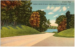
Duck Lake State Park is a public recreation area covering 728 acres (295 ha) along Lake Michigan five miles (8.0 km) southwest of Whitehall in Muskegon County, Michigan. The state park, which runs along the north side of Duck Lake to Lake Michigan, features a large sand dune. The park's Scenic Drive is part of the Shoreline Trail route in Muskegon County.

Aloha State Park is a public recreation area located six miles (9.7 km) south of Cheboygan in Cheboygan County, Michigan. The state park covers 107 acres (43 ha) on the northeast side of Mullett Lake at the center of the Inland Lakes Waterways.

Burt Lake State Park is a public recreation area covering 406 acres (164 ha) on the south shore of Burt Lake at Indian River in Cheboygan County, Michigan. The state park features over 2000 feet of sandy shoreline, swimming, boating access to the Inland Lakes Waterway, fishing on the Sturgeon River and Burt Lake, and camping facilities.
Coldwater Lake State Park is an undeveloped public recreation area occupying 400 acres (160 ha) on the south shore of Coldwater Lake, ten miles (16 km) south of the city of Coldwater in Branch County, Michigan. Money from the Natural Resources Trust Funds was used to create the state park in 1988. Two small, unpaved parking areas offer walk-in access for hunters and fishermen. A general management plan for the park was adopted by the Michigan State Parks Advisory Committee in 2015.

Dodge No. 4 State Park is a public recreation area covering 139 acres (56 ha) on the north shore of Cass Lake in Oakland County, northern Metro Detroit, Michigan. The state park occupies a mile of shoreline on the 1,280-acre (520 ha) lake.
Harrisville State Park is a public recreation area covering 107 acres (43 ha) on the shore of Lake Huron off U.S. Route 23 in Harrisville and Harrisville Township, Alcona County, Michigan. The state park contains more than 100 acres of heavily forested land as well as a mile-long sandy beach. It is considered an important location for birders, with large and varied migratory populations of warblers and other song birds. The park is administered by the Michigan Department of Natural Resources.

Walter J. Hayes State Park is a public recreation area covering 654 acres (265 ha) on the southeast corner of Wamplers Lake in the Irish Hills region of the state of Michigan. Most of the state park lies within Lenawee County with a small portion extending into Jackson and Washtenaw counties in the Round Lake area. The park offers access to 796-acre (322 ha) Wamplers Lake and completely surrounds 100-acre (40 ha) Round Lake, which connects to Wamplers Lake via a channel navigable by smaller boats. Other scenic lakes including Evans Lake and Sand Lake as well as chains of smaller lakes lie nearby. The park is traversed by Michigan Route 124 north of its intersection with US Highway 12.

Ludington State Park is a public recreation area located two miles north of Ludington, Michigan, occupying 5,300 acres (2,100 ha) between the shores of Lake Michigan and Hamlin Lake. The state park is crossed by a one-mile stretch of the Big Sable River and is home to the 112-foot-high (34 m) Big Sable Point Lighthouse, which dates from 1876.

Charles Mears State Park is a public recreation area in the village of Pentwater, Oceana County, Michigan. The state park encompasses 50 acres (20 ha) on the north side of the channel that connects Lake Michigan and Pentwater Lake.

Otsego Lake State Park is a public recreation area covering 62 acres (25 ha) on the southeast shore of Otsego Lake in Otsego Lake Township, Otsego County, Michigan.
Silver Lake State Park is a public recreation area covering 2,936 acres (1,188 ha) that border Lake Michigan and Silver Lake, four miles (6.4 km) west of Mears in Oceana County, Michigan. The state park is composed of mature forest land and over 2,000 acres (810 ha) of sand dunes.

Sleepy Hollow State Park is a public recreation area covering 2,678 acres (1,084 ha) in the townships of Ovid and Victor in Clinton County, Michigan. The state park is located off US-127 nine miles southeast of St. Johns and four miles northwest of Laingsburg and centers on man-made, 410-acre (170 ha) Lake Ovid.
South Higgins Lake State Park is a public recreation area covering 1,000 acres (400 ha) on the southern shore of Higgins Lake five miles southwest of Roscommon in Roscommon County, Michigan. The state park occupies one mile of shoreline on Higgins Lake and entirely surrounds Marl Lake and portions of the Cut River.

Young State Park is a public recreation area near Boyne City, Michigan, occupying 563 acres (228 ha) on the eastern shore of 17,260-acre (6,980 ha) Lake Charlevoix in Charlevoix County in the northwest of Northern Michigan.

Twin Lakes State Park is a 175-acre (71 ha) state park on the western shore of Lake Roland in Houghton County, Michigan. It is located in the Elm River Township, Michigan along M-26.

Seven Lakes State Park is a public recreation area covering 1,434 acres (580 ha) one mile northwest of Holly in Holly Township, Oakland County, Michigan. The state park's 230 acres (93 ha) of water are found in six named lakes that include 170-acre Big Seven Lake, Little Seven Lake, and 44-acre Dickinson Lake.

Pinckney State Recreation Area is a Michigan state recreation area in Dexter, Sylvan and Lyndon Townships, Washtenaw County and Putnam and Unadilla Townships, Livingston County in the U.S. state of Michigan. The park is 11,000 acres (4,500 ha) and sits at an elevation of 922 feet (281 m). The park is connected to the nearby Waterloo State Recreation Area by the 35-mile (56 km) Waterloo–Pinckney Trail. Pinckney State Recreation Area is open for year-round recreation including hiking, fishing, swimming, hunting and a variety of winter sports.

Highland State Recreation Area is a 5,900-acre (2,400 ha) state recreation area in the southeast part of the U.S. state of Michigan. It is located in north Oakland County, 14 miles (23 km) west of Pontiac.

Watkins Lake State Park and County Preserve is a combination public recreation area and nature preserve located five miles west of Manchester in Jackson and Washtenaw counties, Michigan. The area occupies a total of 1,122 acres (454 ha), with the Michigan Department of Natural Resources owning 717 acres (290 ha) in Norvell Township, Jackson County, and Washtenaw County owning 405 acres (164 ha) in Manchester Township. Dedicated in 2017, it is under the joint management of the Michigan DNR and the Washtenaw County Parks & Recreation Commission. A five-mile former rail corridor runs through the park and into grasslands in the eastern portion of the preserve.

