
The Porcupine Mountains, or Porkies, are a group of small mountains spanning the northwestern Upper Peninsula of Michigan in Ontonagon and Gogebic counties, near the shore of Lake Superior. The Porcupine Mountains were named by the native Ojibwa people, supposedly because their silhouette had the shape of a crouching porcupine. They are home to the most extensive stand of old growth northern hardwood forest in North America west of the Adirondack Mountains, spanning at least 31,000 acres (13,000 ha). The area is popular among tourists, especially Lake of the Clouds in the heart of the mountains, and is part of Porcupine Mountains Wilderness State Park.

Fayette Historic State Park is the state park of the historic town of Fayette in the U.S. state of Michigan. It is located on the Big Bay de Noc of Lake Michigan, between Snail Shell Harbor and Sand Bay, on the southern side of the Upper Peninsula, about 17 miles south of US 2. Fayette was the site of an industrial community that manufactured charcoal pig iron between 1867 and 1891. The town has been reconstructed into a living museum, showing what life was like in this town in the late 19th century. It was listed on the National Register of Historic Places in 1970.
M-35 is a state trunkline highway in the Upper Peninsula (UP) of the US state of Michigan. It runs for 128 miles (206 km) in a general north–south direction and connects the cities of Menominee, Escanaba, and Negaunee. The southern section of M-35 in Menominee and Delta counties carries two additional designations; M-35 forms a segment of the Lake Michigan Circle Tour, and it is the UP Hidden Coast Recreational Heritage Trail, which is a part of what is now called the Pure Michigan Byways Program. Along the southern section, the highway is the closest trunkline to the Green Bay, a section of Lake Michigan. The northern section of the highway turns inland through sylvan areas of the UP, connecting rural portions of Delta and Marquette counties.

Clear Creek State Forest is a Pennsylvania State Forest in Pennsylvania Bureau of Forestry District #8. The main offices are located in Clarion in Clarion County, Pennsylvania in the United States. Until August 2007, it was named Kittanning State Forest.

William Penn State Forest is a Pennsylvania State Forest in Pennsylvania Bureau of Forestry District #17. The main offices are located in Elverson in Chester County, Pennsylvania in the United States.

Hartwick Pines State Park is a public recreation area covering 9,762 acres (3,951 ha) in Crawford County near Grayling and Interstate 75 on the Lower Peninsula of the U.S. state of Michigan. The state park contains an old-growth forest of white pines and red pines, known as the Hartwick Pines, that resembles the appearance of all Northern Michigan prior to the logging era.
The Thunder Bay River is a 75.4-mile-long (121.3 km) river in the U.S. state of Michigan. It drains much of Alpena County and Montmorency County, and a small portion of Oscoda County, into Thunder Bay on the eastern side of northern Michigan. The mouth of the river is in the heart of downtown Alpena and is guarded by the Alpena Light Station.

Interlochen State Park is a public recreation area covering 187 acres (76 ha) between Green Lake and Duck Lake in Grand Traverse County, Michigan. It was the State of Michigan's first officially recognized state park. It was established by the Michigan Legislature in 1917; $60,000 was paid for the land. Originally named Pine Park, the park was created to preserve for future generations the virgin pine (Pinus strobus) stand. It is one of the few easily reached places in Michigan where old-growth red pine can be found.

The Mackinaw State Forest is a 717,500-acre (2,904 km2) forested area owned by the U.S. state of Michigan and operated by the Michigan Department of Natural Resources. It is located in the northern area of the Lower Peninsula within the eight counties of Alpena, Antrim, Charlevoix, Cheboygan, Emmet, Montmorency, Otsego, and Presque Isle. The forest is served by Interstate 75, U.S. Highway 23 (US 23), and US 131.
Lake Superior State Forest is a state forest in the Upper Peninsula of Michigan. It is operated by the Michigan Department of Natural Resources. The North Country Trail utilizes this state forest for 43 miles (69 km) of its route.
Copper Country State Forest is a state forest in the west-central Upper Peninsula of Michigan. It is operated by the Michigan Department of Natural Resources.
The Au Sable State Forest is a state forest in the north-central Lower Peninsula of Michigan. It is operated by the Michigan Department of Natural Resources.

Laughing Whitefish Falls State Park is a public recreation area protecting 960 acres (390 ha) along the Laughing Whitefish River in Onota Township and Rock River Township, in far western Alger County, Michigan. Its main scenic feature is Laughing Whitefish Falls, a 100-foot fan-shaped cascade located in the southern part of the site, in Rock River Township, eight miles (13 km) south of Lake Superior and three miles north of M-94.

Pinckney State Recreation Area is a Michigan state recreation area in Dexter, Sylvan and Lyndon Townships, Washtenaw County and Putnam and Unadilla Townships, Livingston County in the U.S. state of Michigan. The park is 11,000 acres (4,500 ha) and sits at an elevation of 922 feet (281 m). The park is connected to the nearby Waterloo State Recreation Area by the 35-mile (56 km) Waterloo–Pinckney Trail. Pinckney State Recreation Area is open for year-round recreation including hiking, fishing, swimming, hunting and a variety of winter sports.
US Highway 2 (US 2) is a component of the United States Numbered Highway System that connects Everett, Washington, to the Upper Peninsula (UP) of the US state of Michigan, with a separate segment that runs from Rouses Point, New York, to Houlton, Maine. In Michigan, the highway runs through the UP in two segments as a part of the state trunkline highway system, entering the state at Ironwood and ending at St. Ignace; in between, US 2 briefly traverses the state of Wisconsin. As one of the major transportation arteries in the UP, US 2 is a major conduit for traffic through the state and neighboring northern Midwest states. Two sections of the roadway are included as part of the Great Lakes Circle Tours, and other segments are listed as state-designated Pure Michigan Byways. There are several memorial highway designations and historic bridges along US 2 that date to the 1910s and 1920s. The highway runs through rural sections of the UP, passing through two national and two state forests in the process.
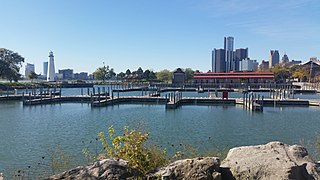
The William G. Milliken State Park and Harbor is a public recreation area located on the Detroit River just east of downtown Detroit, Michigan, on a portion of the city's International Riverfront. The state park's 31 acres (13 ha) include wetlands, paved trails, and a 52-slip harbor of refuge. A 63-foot (19 m) conical brick lighthouse tower, designed as a scaled-down replica of the Tawas Point Light, marks the harbor entrance.
The Lost River State Forest is a state forest located in Roseau County, Minnesota. The forest borders the Canadian province of Manitoba to the north, and parcels belonging to the Red Lake Indian Reservation are within the forest's boundaries. The forest is managed by the Minnesota Department of Natural Resources.
Menominee River State Recreation Area is a state-managed protected area located in Breitung and Norway townships in Dickinson County and Faithorn Township in Menominee County, Michigan, southeast of Iron Mountain. It is 2,354 acres (953 ha) in area and is currently undeveloped. The park comprises a 145.35-acre (58.82 ha) tract along 1.5 miles (2.4 km) of the Menominee River south of the City of Norway and the 2,208.83-acre (893.88 ha) Quiver Falls Tract along eight miles (13 km) of the river farther downstream. In 2016, an additional 525-acre (212 ha) of Escanaba State Forest land was transferred from the Forestry Division to the DNR's Parks and Recreation Division and became the Pemene Falls Unit of the park, matching a similarly-named unit on the Wisconsin side of the river.


