
Transylvania County is a county in the U.S. state of North Carolina. As of the 2020 census the population is 32,986. Its county seat is Brevard.

The Oxley Wild Rivers National Park is a protected national park that is located in the Northern Tablelands region of New South Wales, Australia in the Port Macquarie-Hastings City Council and Walcha Shire councils. The 145,223-hectare (358,850-acre) park is situated 445 kilometres (277 mi) north of Sydney and is named in memory of the Australian explorer John Oxley, who passed through the area in 1818 and is one of the largest national parks in New South Wales.

Ocqueoc Township is a civil township of Presque Isle County in the U.S. state of Michigan named after the Ocqueoc River. The population of Ocqueoc Township was 634 at the 2000 census and slightly increased at 655 at the 2010 census.

Franklin is a town in and the county seat of Macon County, North Carolina, United States. It is situated within the Nantahala National Forest. The population was reported to be 4,175 in the 2020 census, an increase from the total of 3,845 tabulated in 2010.

Spencer is a town in Van Buren County, Tennessee, United States. The population was 1,683 as of the 2010 census. It is the county seat of Van Buren County. It is home to Fall Creek Falls State Park.

The Columbia River Gorge is a canyon of the Columbia River in the Pacific Northwest of the United States. Up to 4,000 feet (1,200 m) deep, the canyon stretches for over eighty miles (130 km) as the river winds westward through the Cascade Range, forming the boundary between the state of Washington to the north and Oregon to the south. Extending roughly from the confluence of the Columbia with the Deschutes River in the east down to the eastern reaches of the Portland metropolitan area, the water gap furnishes the only navigable route through the Cascades and the only water connection between the Columbia Plateau and the Pacific Ocean. It is thus that the routes of Interstate 84, U.S. Route 30, Washington State Route 14, and railroad tracks on both sides run through the gorge.

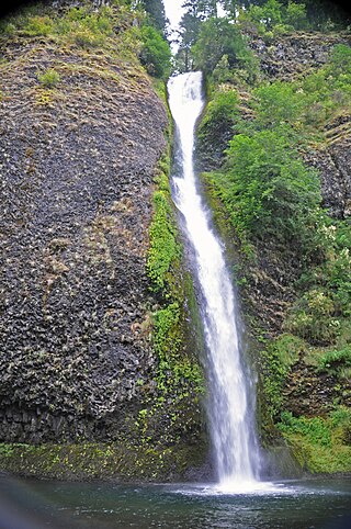
Multnomah Falls is a waterfall located on Multnomah Creek in the Columbia River Gorge, east of Troutdale, between Corbett and Dodson, Oregon, United States. The waterfall is accessible from the Historic Columbia River Highway and Interstate 84. Spanning two tiers on basalt cliffs, it is the tallest waterfall in the state of Oregon at 620 ft (189 m) in height. The Multnomah Creek Bridge, built in 1914, crosses below the falls, and is listed on the National Register of Historic Places.
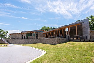
Gorges State Park is a 7,709-acre (31.20 km2) North Carolina state park in Transylvania County, North Carolina in the United States and along with other conservation lands is part of a 100,000+ acre conservation corridor stretching some 80 miles along the NC/SC state line. The land, along Jocassee Gorges, was purchased by the state from Duke Energy Corporation in 1999. It is North Carolina's westernmost state park and one of the state's newest. The park is adjacent to part of the Pisgah National Forest and the N.C. Wildlife Resources Commission's Toxaway Game Land. Gorges State Park provides the principal access to the Horsepasture River on these adjoining public lands.

Fall Creek Falls State Resort Park is a state park in Van Buren and Bledsoe counties, in the U.S. state of Tennessee. The over 30,638-acre (123.99 km2) park is centered on the upper Cane Creek Gorge, an area known for its unique geological formations and scenic waterfalls. The park's namesake is the 256-foot (78 m) Fall Creek Falls, the highest free-fall waterfall east of the Mississippi River.
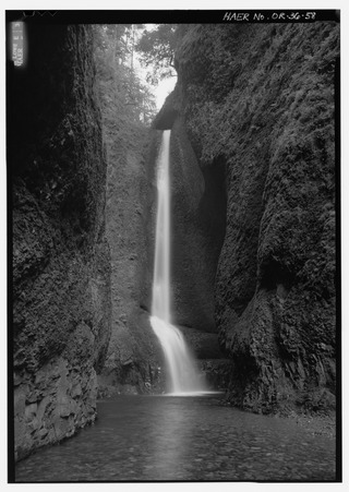
Oneonta Gorge is a scenic gorge located in the Columbia River Gorge area of the American state of Oregon. The U.S. Forest Service has designated it as a botanical area because of the unique aquatic and woodland plants that grow there. Exposed walls of 25-million-year-old basalt are home to a wide variety of ferns, mosses, hepatics, and lichens, many of which grow only in the Columbia River Gorge. Oneonta Gorge with its 50 species of wildflowers, flowering shrubs and trees has been described as "one of the true dramatic chasms in the state." The Oneonta Gorge Creek Bridge is listed on the National Register of Historic Places.
Horsetail Falls is a waterfall located on Horsetail Creek along the Columbia River Gorge in Multnomah County, in the U.S. state of Oregon. The falls drop over a cut over the columnar basalt cliff within the Oneonta Gorge. It is one of the waterfalls along the Columbia River Highway's waterfall corridor.
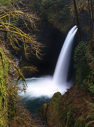
Eagle Creek is a creek located mainly in Hood River County, Oregon, in the Columbia River Gorge, with its last roughly 0.5 miles (0.80 km) and mouth in Multnomah County. A tributary of the Columbia River, the creek flows for approximately 15 miles (24 km) from the Thrush Pond between Eagle Butte and Tanner Butte to its mouth near Bonneville Dam. The East Fork Eagle Creek is a major tributary that begins at Wahtum Lake and joins the main stem approximately 2/3 the way between the Thrush Pond and the Columbia River, separated by Indian Mountain.

The Ottawa National Forest is a national forest that covers 993,010 acres (401,860 ha) in the Upper Peninsula of the U.S. state of Michigan. It includes much of Gogebic and Ontonagon counties, as well as slices of Iron, Houghton, Baraga, and Marquette counties. The forest is under the jurisdiction of the U.S. Forest Service.
The Black River is a 41.1-mile-long (66.1 km) river on the Upper Peninsula of the U.S. state of Michigan, flowing mostly in Gogebic County into Lake Superior at 46°40′03″N90°02′57″W. Its source at 46°18′54″N90°01′15″W is a boreal wetland on the border with Iron County, Wisconsin. The northern section of the river, 14 miles (23 km) within the boundaries of the Ottawa National Forest, was designated a National Wild and Scenic River in 1992.

Ozone Falls State Natural Area is a state natural area in Cumberland County, Tennessee in the southeastern United States. It consists of 43 acres (0.17 km2) centered on Ozone Falls, a 110-foot (34 m) plunge waterfall, and its immediate gorge along Fall Creek. Because of its picturesque beauty and easy access, Disney selected Ozone Falls for scenes for their live-action film "Rudyard Kipling's The Jungle Book". The area is managed by the Tennessee Department of Environment and Conservation and maintained by Cumberland Mountain State Park. It is also part of Cumberland Trail State Park.

John B. Yeon State Scenic Corridor is a state park in the U.S. state of Oregon, administered by the Oregon Parks and Recreation Department. It is located about 35 miles east of Portland in the Columbia Gorge. It is named in honor of John B. Yeon, one of the principal financiers of the Historic Columbia River Highway U.S. Route 30 which was constructed between 1913 and 1922. Located in the Columbia River Gorge National Scenic Area, the park features hiking trails that access some of the nearby waterfalls, including Elowah Falls.

The Ocqueoc River is a 34.2-mile-long (55.0 km) blackwater river in the U.S. state of Michigan. The river is located in the northeastern Lower Peninsula, flowing into Lake Huron in Presque Isle County. The river drains a watershed of approximately 94,394 acres (382.00 km2). Along the river are the Ocqueoc Falls, the largest and only named waterfall in Michigan's Lower Peninsula.

The Black River National Forest Scenic Byway is a National Forest Scenic Byway that runs along the Black River in the Ottawa National Forest in the U.S. state of Michigan. The byway follows County Road 513 (CR 513) through Gogebic County in the Upper Peninsula. As a county road, it is maintained jointly by the Gogebic County Road Commission (GCRC) with assistance from the U.S. Forest Service (USFS). The byway provides access to several waterfalls and other visitor attractions in the area. The route of the byway first existed as a wagon road in the 1840s and as a county road in the 1920s. The byway designation was instituted on June 20, 1992, and the byway was dedicated later that year.
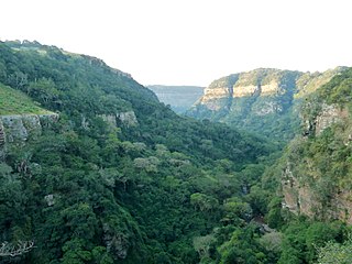
The Krantzkloof Nature Reserve, managed by Ezemvelo KZN Wildlife, conserves 668 ha of the Molweni and Nkutu River gorges that incise the sandstone Kloof plateau in KwaZulu-Natal, South Africa. The reserve conserves coastal scarp forest, sourveld grassland, a cliff face biotope, and aquatic environments along its rivers. Scarp forest is a threatened forest type, protected by South Africa's forests act of 1998, while the grassland is classified as KwaZulu-Natal sandstone sourveld, the most threatened terrestrial habitat in the Durban metropole. The reserve was established in 1950 and was augmented by land donations as late as 1999.
Tanner Creek is a creek located in the Columbia River Gorge in Multnomah County, Oregon, United States, that is a tributary of the Columbia River.

