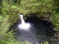
Waterfall

Last updated

Dynjandi, a series of waterfalls located in the Westfjords (Vestfirdir), Iceland. Cascada Dynjandi, Vestfirdir, Islandia, 2014-08-14, DD 136-138 HDR.JPG
Dynjandi, a series of waterfalls located in the Westfjords (Vestfirðir), Iceland.

A waterfall is any point in a river or stream where water flows over a vertical drop or a series of steep drops. Waterfalls also occur where meltwater drops over the edge of a tabular iceberg or ice shelf.

Contents

Waterfalls can be formed in several ways, but the most common method of formation is that a river courses over a top layer of resistant bedrock before falling onto softer rock, which erodes faster, leading to an increasingly high fall. Waterfalls have been studied for their impact on species living in and around them.

Humans have had a distinct relationship with waterfalls for years, travelling to see them, exploring and naming them. They can present formidable barriers to navigation along rivers. Waterfalls are religious sites in many cultures. Since the 18th century, they have received increased attention as tourist destinations, sources of hydropower, andparticularly since the mid-20th centuryas subjects of research.

Definition and terminology

A waterfall is generally defined as a point in a river where water flows over a steep drop that is close to or directly vertical. In 2000 Mabin specified that "The horizontal distance between the positions of the lip and plunge pool should be no more than c 25% of the waterfall height." There are various types and methods to classify waterfalls. [1] Some scholars have included rapids as a subsection. [2] What actually constitutes a waterfall continues to be debated. [3]

Waterfalls are sometimes interchangeably referred to as "cascades" and "cataracts", though some sources specify a cataract as being a larger and more powerful waterfall [1] [4] [5] and a cascade as being smaller. [6] A plunge pool is a type of stream pool formed at the bottom of a waterfall. [7] A waterfall may also be referred to as a "foss" or "force". [8] [9]

Formation

Formation of a waterfall WaterfallCreationDiagram.svg
Formation of a waterfall

Waterfalls are commonly formed in the upper course of a river where lakes flow into valleys in steep mountains. [10]

A river sometimes flows over a large step in the rocks that may have been formed by a fault line. Waterfalls can occur along the edge of a glacial trough, where a stream or river flowing into a glacier continues to flow into a valley after the glacier has receded or melted. The large waterfalls in Yosemite Valley are examples of this phenomenon, which is referred to as a hanging valley. Another reason hanging valleys may form is where two rivers join and one is flowing faster than the other. [10]

When warm and cold water meets by a gorge in the ocean, large underwater waterfalls can form as the cold water rushes to the bottom. [11]

Caprock model

The caprock model of waterfall formation [12] states that the river courses over resistant bedrock, erosion happens slowly and is dominated by impacts of water-borne sediment on the rock, while downstream the erosion occurs more rapidly. [10] [13] As the watercourse increases its velocity at the edge of the waterfall, it may pluck material from the riverbed, if the bed is fractured or otherwise more erodible. Hydraulic jets and hydraulic jumps at the toe of a falls can generate large forces to erode the bed, [14] especially when forces are amplified by water-borne sediment. Horseshoe-shaped falls focus the erosion to a central point, also enhancing riverbed change below a waterfall. [15]

A process known as "potholing" involves local erosion of a potentially deep hole in bedrock due to turbulent whirlpools spinning stones around on the bed, drilling it out. Sand and stones carried by the watercourse therefore increase erosion capacity. [10] This causes the waterfall to carve deeper into the bed and to recede upstream. Often over time, the waterfall will recede back to form a canyon or gorge downstream as it recedes upstream, and it will carve deeper into the ridge above it. [16] The rate of retreat for a waterfall can be as high as one-and-a-half metres per year. [10]

Often, the rock stratum just below the more resistant shelf will be of a softer type, meaning that undercutting due to splashback will occur here to form a shallow cave-like formation known as a rock shelter under and behind the waterfall. Eventually, the outcropping, more resistant cap rock will collapse under pressure to add blocks of rock to the base of the waterfall. These blocks of rock are then broken down into smaller boulders by attrition as they collide with each other, and they also erode the base of the waterfall by abrasion, creating a deep plunge pool in the gorge downstream. [17]

Streams can become wider and shallower just above waterfalls due to flowing over the rock shelf, and there is usually a deep area just below the waterfall because of the kinetic energy of the water hitting the bottom. However, a study of waterfalls systematics reported that waterfalls can be wider or narrower above or below a falls, so almost anything is possible given the right geological and hydrological setting. [18] Waterfalls normally form in a rocky area due to erosion. After a long period of being fully formed, the water falling off the ledge will retreat, causing a horizontal pit parallel to the waterfall wall. Eventually, as the pit grows deeper, the waterfall collapses to be replaced by a steeply sloping stretch of river bed. [10] In addition to gradual processes such as erosion, earth movement caused by earthquakes or landslides or volcanoes can lead to the formation of waterfalls. [17]

Ecology

Ulaan tsutgalan in Mongolia During Summer 2023, the background is showing more geological structures formations and farther geological features Ulaan tsutgalan, Mongolia.jpg
Ulaan tsutgalan in Mongolia During Summer 2023, the background is showing more geological structures formations and farther geological features
The Dettifoss in Iceland on 31 July 1972 Iceland Dettifoss 1972-4.jpg
The Dettifoss in Iceland on 31 July 1972

Waterfalls are an important factor in determining the distribution of lotic organisms such as fish and aquatic invertebrates, as they may restrict dispersal along streams. The presence or absence of certain species can have cascading ecological effects, and thus cause differences in trophic regimes above and below waterfalls. Certain aquatic plants and insects also specialize in the environment of the waterfall itself. [19] [20] A 2012 study of the Agbokim Waterfalls, has suggested that they hold biodiversity to a much higher extent than previously thought. [21]

Waterfalls also affect terrestrial species. They create a small microclimate in their immediate vicinity characterized by cooler temperatures and higher humidity than the surrounding region, which may support diverse communities of mosses and liverworts. Species of these plants may have disjunct populations at waterfall zones far from their core range. [22]

Waterfalls provide nesting cover for several species of bird, such as the black swift and white-throated dipper. These species preferentially nest in the space behind the falling water, which is thought to be a strategy to avoid predation. [23]

Types

TypeImageNotes
Ledge waterfall American Falls Niagara Falls USA from Skylon Tower on 2002-05-28.png Water descends vertically over a vertical cliff, maintaining partial contact with the bedrock. [24] May be several types:
  • Block/Sheet: Water descends from a relatively wide stream or river. [13]
  • Classical: Fall height is nearly equal to stream width, forming a square shape. [13]
  • Curtain: Fall height is greater than the width of the falling water stream. [13]
Plunge BrandywineFalls 1200W.jpg Fast-moving water falls vertically, completely losing contact with the bedrock surface. [17]
Punchbowl Punch Bowl Falls.jpg Water is constricted as it falls and then spreads into a wider pool. [13]
Horsetail Jog Falls 05092016.jpg Falling water mostly maintains contact with bedrock. [17] Several types:
  • Chute: A large quantity of water forced through a narrow, vertical passage. [25]
  • Fan: Water spreads horizontally as it falls while remaining in contact with bedrock. [17]
Cascade Numa Falls Upstream.jpg Water descends a series of rock steps. [13]
Tiered/Multi-step/Staircase Upper ebor falls small.jpg A series of waterfalls one after another of roughly the same size each with its own sunken plunge pool. [17]
Cataract VictoriaFalls2018d.jpg A large, powerful waterfall. [17]
Segmented Magod Falls Karnataka.JPG Distinct flows of water form as it descends. [17]
Moulin Moulin on Snowbird Glacier, below the Snowbird Glacier Hut. Talkeetna Mountains, Alaska.JPG A waterfall in a glacier. [26]
An example of an ephemeral waterfall. This one, when flowing, feeds into the Chagrin River. An ephemeral waterfall.jpg
An example of an ephemeral waterfall. This one, when flowing, feeds into the Chagrin River.

Some waterfalls are also distinct in that they do not flow continuously. Ephemeral waterfalls only flow after a rain or a significant snowmelt. [27] [28] [29] Waterfalls can also be found underground [30] and in oceans. [11]

Humans and waterfalls

Research

The geographer Andrew Goudie wrote in 2020 that waterfalls have received "surprisingly limited research." [31] Alexander von Humboldt wrote about them in the 1820s. [32] There is no name for the specific field of researching waterfalls, and in the published literature been described as "scattered", [33] though it is popular to describe studying waterfalls as "waterfallology". [34] An early paper written on waterfalls was published in 1884 by William Morris Davis, a geologist known as the "father of American geography". In the 1930s Edward Rashleigh published a pioneering work on waterfalls. [2] In 1942 Oscar von Engeln wrote of the lack of research on waterfalls: [35]

Waterfall sites more than any other geomorphic feature attract and hold the interest of the general public. Because they have such a popular approval waterfalls are not given serious attention by some students of systematic geomorphology. This attitude is not to be commended. Waterfalls are significant items for geomorphic investigation.

As late as 1985 a scholar felt that "waterfalls remain a very much neglected aspect of river studies". [36] Studies of waterfalls increased dramatically in the second half of the 20th century. Numerous waterfall guidebooks exist, and the World Waterfall Database is a website cataloging thousands of waterfalls. [2]

Exploration and naming

Niagara Falls, from the American Side (Frederic Edwin Church, 1867) Frederic Edwin Church - Niagara Falls, from the American Side - Google Art Project.jpg
Niagara Falls, from the American Side (Frederic Edwin Church, 1867)

Many explorers have visited waterfalls. [31] European explorers recorded waterfalls they came across. In 1493, Christopher Columbus noted Carbet Falls in Guadeloupe, which was likely the first waterfall Europeans recorded seeing in the Americas. In the late 1600s, Louis Hennepin visited North America, providing early descriptions of Niagara Falls and the Saint Anthony Falls. The geographer Brian J. Hudson argues that it was uncommon to specifically name waterfalls until the 1700s. The trend of Europeans specifically naming falls was in tandem with increased scientific focus on nature, the rise of Romanticism, and increased importance of hydropower with the Industrial Revolution. European explorers often ignored the names native peoples had given the falls in favor of a "European" name; for instance, David Livingstone named Victoria Falls after Queen Victoria, though it was already known as Mosi-oa-Tunya. Many waterfalls have descriptive names which can come from the river they are on, places they are near, their features, or events that happened near them. [2]

Some countries that were colonized by European nations have taken steps to return names to waterfalls previously renamed by European explorers. [2] Exploration of waterfalls continues; the Gocta Cataracts were first announced to the world in 2006. [37]

Waterfalls can pose major barriers to travel. Canals are sometimes built as a method to go around them, other times things must be physically carried around or a railway built. [17] [38] In 1885, the geographer George Chisholm wrote that, "The most signal example of the effect of waterfalls and rapids in retarding the development of civilisation is undoubtedly presented by the continent of Africa, the 'darkness' of which is almost entirely due to this cause." [39]

Development and tourism

Waterfalls are often visited by people simply to see them. Hudson theorizes that they make good tourism sites because they are generally considered beautiful and are relatively uncommon. [40] Activities at waterfalls can include bathing, swimming, photography, rafting, canyoning, abseiling, rock climbing, and ice climbing. [35] Waterfalls can also be sites for generating hydroelectric power and can hold good fishing opportunities. [41] Wealthy people were known to visit areas with features such as waterfalls at least as early as in Ancient Rome and China. However, many waterfalls were essentially inaccessible due to the treacherous terrain surrounding them until improvements began to be made such as paths to the falls, becoming common across the United Kingdom and America in the 1800s and continuing through the 1900s and into the 21st century. Remote waterfalls are now often visited by air travel. [40]

Human development has also threatened many waterfalls. For instance, the Guaíra Falls, once one of the most powerful waterfalls in the world, were submerged in 1982 by a human-made dam, as were the Ripon Falls in 1952. Conversely, other waterfalls have seen significantly lower water levels as a result of diversion for hydroelectricity, such as the Tyssestrengene in Norway. [42] Development of the areas around falls as tourist attractions has also destroyed the natural scene around many of them. [40]

Waterfalls are included on thirty-eight World Heritage Sites [31] and many others are protected by governments. [43]

In culture

A man practicing sadhana in Japan Taki-gyo 8118084.jpg
A man practicing sādhanā in Japan

Waterfalls play a role in many cultures, as religious sites and subjects of art and music. [31] [43]

Many artists have painted waterfalls and they are referenced in many songs, such as those of the Kaluli people in Papua New Guinea. Michael Harner titled his study of the Jivaroan peoples of Ecuador The Jivaro: People of the Sacred Waterfalls. [43] Artists such as those of the Hudson River School and J. M. W. Turner and John Sell Cotman painted particularly notable pictures of waterfalls in the 19th century. [44]

One of the versions of the Shinto purification ceremony of misogi involves standing underneath a waterfall in ritual clothing. [45] In Japan the Nachi Falls are a site of pilgrimage, as are falls near Tirupati, India, and the Saut-d'Eau, Haiti. [43] The Otavalos use Piguchi waterfall as part of the Churru ritual which serves as a coming of age ceremony. [46] Many waterfalls in Africa were places of worship for the native peoples and got their names from gods in the local religion. [21]

"In Chinese tradition, the waterfall represents" the season of autumn, yin, and the Chinese dragon's power over water that comes from the former two. [47]

List

Shaki Waterfall in Armenia Shaki Waterfall2.jpg
Shaki Waterfall in Armenia

There are thousands of waterfalls in the world, though no exact number has been calculated. The World Waterfall Database lists 7,827 as of 2013, but this is likely incomplete; as noted by Hudson, over 90% of their listings are in North America. Many guidebooks to local waterfalls have been published. [3] There is also no agreement how to measure the height of a waterfall, [1] or even what constitutes one. [3] Angel Falls in Venezuela is the tallest waterfall in the world, the Khone Phapheng Falls in Laos are the widest, [17] and the Inga Falls on the Congo River are the biggest by flow rate, [48] while the Dry Falls in Washington are the largest confirmed waterfalls ever. [49] The highest known subterranean waterfall is in Vrtoglavica Cave in Slovenia. [50] The Denmark Strait cataract is an undersea overflow which could be considered a "waterfall" under a very broad usage of that term; if so included, it is the largest known waterfall. [11]

Artificial waterfalls are water features or fountains that imitate a natural waterfall. [51] The Cascata delle Marmore is the tallest artificially built waterfall at 541 feet (165 m). [52]

Related Research Articles

<span class="mw-page-title-main">Erosion</span> Natural processes that remove soil and rock

Erosion is the action of surface processes that removes soil, rock, or dissolved material from one location on the Earth's crust and then transports it to another location where it is deposited. Erosion is distinct from weathering which involves no movement. Removal of rock or soil as clastic sediment is referred to as physical or mechanical erosion; this contrasts with chemical erosion, where soil or rock material is removed from an area by dissolution. Eroded sediment or solutes may be transported just a few millimetres, or for thousands of kilometres.

<span class="mw-page-title-main">Iguazu Falls</span> Waterfalls on the Iguazú River on the border of Argentina and Brazil

Iguazú Falls or Iguaçu Falls are waterfalls of the Iguazu River on the border of the Argentine province of Misiones and the Brazilian state of Paraná. Together, they make up the largest waterfall system in the world. The falls divide the river into the upper and lower Iguazu. The Iguazu River rises near the heart of the city of Curitiba. For most of its course, the river flows through Brazil; however, most of the falls are on the Argentine side. Below its confluence with the San Antonio River, the Iguazu River forms the border between Argentina and Brazil.

<span class="mw-page-title-main">Yosemite Valley</span> Glacial valley in California, United States

Yosemite Valley is a glacial valley in Yosemite National Park in the western Sierra Nevada mountains of Central California, United States. The valley is about 7.5 mi (12.1 km) long and 3,000–3,500 ft (910–1,070 m) deep, surrounded by high granite summits such as Half Dome and El Capitan, and densely forested with pines. The valley is drained by the Merced River, and a multitude of streams and waterfalls flow into it, including Tenaya, Illilouette, Yosemite and Bridalveil Creeks. Yosemite Falls is the highest waterfall in North America and is a big attraction, especially in the spring, when the water flow is at its peak. The valley is renowned for its natural environment and is regarded as the centerpiece of Yosemite National Park.

<span class="mw-page-title-main">Niagara Falls</span> Waterfalls between United States and Canada

Niagara Falls is a group of three waterfalls at the southern end of Niagara Gorge, spanning the border between the province of Ontario in Canada and the state of New York in the United States. The largest of the three is Horseshoe Falls, which straddles the international border of the two countries. It is also known as the Canadian Falls. The smaller American Falls and Bridal Veil Falls lie within the United States. Bridal Veil Falls is separated from Horseshoe Falls by Goat Island and from American Falls by Luna Island, with both islands situated in New York.

<span class="mw-page-title-main">Victoria Falls</span> Waterfall on the Zambezi River in Zambia and Zimbabwe

Victoria Falls is a waterfall on the Zambezi River in southern Africa, which provides habitat for several unique species of plants and animals. It is located on the border between Zambia and Zimbabwe and is one of the world's largest waterfalls, with a width of 1,708 m (5,604 ft).

<span class="mw-page-title-main">Fluvial sediment processes</span> Sediment processes associated with rivers and streams

In geography and geology, fluvial sediment processes or fluvial sediment transport are associated with rivers and streams and the deposits and landforms created by sediments. It can result in the formation of ripples and dunes, in fractal-shaped patterns of erosion, in complex patterns of natural river systems, and in the development of floodplains and the occurrence of flash floods. Sediment moved by water can be larger than sediment moved by air because water has both a higher density and viscosity. In typical rivers the largest carried sediment is of sand and gravel size, but larger floods can carry cobbles and even boulders. When the stream or rivers are associated with glaciers, ice sheets, or ice caps, the term glaciofluvial or fluvioglacial is used, as in periglacial flows and glacial lake outburst floods. Fluvial sediment processes include the motion of sediment and erosion or deposition on the river bed.

<span class="mw-page-title-main">Grand Coulee</span> Ancient river bed in the U.S. state of Washington

Grand Coulee is an ancient river bed in the U.S. state of Washington. This National Natural Landmark stretches for about 60 miles (100 km) southwest from Grand Coulee Dam to Soap Lake, being bisected by Dry Falls into the Upper and Lower Grand Coulee.

<span class="mw-page-title-main">Celilo Falls</span> Historical waterfall on the Columbia River in Washington (state), United States

Celilo Falls was a tribal fishing area on the Columbia River, just east of the Cascade Mountains, on what is today the border between the U.S. states of Oregon and Washington. The name refers to a series of cascades and waterfalls on the river, as well as to the native settlements and trading villages that existed there in various configurations for 15,000 years. Celilo was the oldest continuously inhabited community on the North American continent until 1957, when the falls and nearby settlements were submerged by the construction of The Dalles Dam. In 2019, there were calls by tribal leaders to restore the falls.

<span class="mw-page-title-main">Agua Azul</span> Cataracts on the Xanil River in Chiapas, Mexico

The Cascadas de Agua Azul are a series of waterfalls found on the Xanil River in the southern Mexican state of Chiapas. They are located in the Municipality of Tumbalá, 69 kilometres (43 mi) from Palenque, near Mexican Federal Highway 199.

<span class="mw-page-title-main">Knickpoint</span> Point on a streams profile where a sudden change in stream gradient occurs

In geomorphology, a knickpoint or nickpoint is part of a river or channel where there is a sharp change in channel bed slope, such as a waterfall or lake. Knickpoints reflect different conditions and processes on the river, often caused by previous erosion due to glaciation or variance in lithology. In the cycle of erosion model, knickpoints advance one cycle upstream, or inland, replacing an older cycle. A knickpoint that occurs at the head of a channel is called a headcut. Headcuts resulting in headward erosion are hallmarks of unstable expanding drainage features such as actively eroding gullies.

<span class="mw-page-title-main">Plunge pool</span> Depression at the base of a waterfall

A plunge pool is a deep depression in a stream bed at the base of a waterfall or shut-in. It is created by the erosional forces of cascading water on the rocks at the formation's base where the water impacts. The term may refer to the water occupying the depression, or the depression itself.

<span class="mw-page-title-main">Augrabies Falls</span> Waterfall in Northern Cape, South Africa

The Augrabies Falls is a waterfall on the Orange River, the largest river in South Africa. Since 1966 the waterfall, set in a desolate and rugged milieu, is enclosed by the Augrabies Falls National Park. The falls are around 183 feet (56 m) in height. Some sources cite an approximate height of 480 feet; this is actually the height from the base of the canyon to the top of the walls, not that of the falls themselves.

<span class="mw-page-title-main">Chunchanakatte Falls</span>

Chunchanakatte Falls is a waterfall on the Kaveri River, near the village of Chunchanakatte in saligrama taluk of Mysore district, Karnataka, India. Water cascades from a height of about 20 meters. It is in the Western Ghats. Here the river falls in two small cascades before joining again to flow as one.

<span class="mw-page-title-main">Geology of the Pacific Northwest</span> Geology of Oregon and Washington (United States) and British Columbia (Canada)

The geology of the Pacific Northwest includes the composition, structure, physical properties and the processes that shape the Pacific Northwest region of North America. The region is part of the Ring of Fire: the subduction of the Pacific and Farallon Plates under the North American Plate is responsible for many of the area's scenic features as well as some of its hazards, such as volcanoes, earthquakes, and landslides.

<span class="mw-page-title-main">Stream</span> Body of surface water flowing down a channel

A stream is a continuous body of surface water flowing within the bed and banks of a channel. Depending on its location or certain characteristics, a stream may be referred to by a variety of local or regional names. Long, large streams are usually called rivers, while smaller, less voluminous and more intermittent streams are known as streamlets, brooks or creeks.

Waterfall Country is a name often given to the upper reaches of the Vale of Neath in South Wales. The tourist area around the head of the valley has an unusually large number of publicly accessible waterfalls. The area is not officially defined but generally includes the group of falls on the Nedd Fechan, Pyrddin, Hepste and Mellte rivers, all of which lie between the villages of Pontneddfechan and Ystradfellte in the Brecon Beacons National Park.

<span class="mw-page-title-main">Havasu Creek</span> Stream in Arizona, United States of America

Havasu Creek is a stream in the U.S. state of Arizona associated with the Havasupai people. It is a tributary to the Colorado River, which it enters in the Grand Canyon.

<span class="mw-page-title-main">Jägala Waterfall</span> Waterfall in Estonia

Jägala Waterfall is a waterfall in northern Estonia on the Jägala River. It is the largest natural waterfall in Estonia, with a width of about 50 meters (160 ft) and a height of about 8 meters (26 ft). Jägala Falls is located in Koogi in Harju County. Jägala Falls is located in Koogi in Harju County. Jägala Falls is also the most powerful waterfall in Estonia, cascading 12.8 cubic meters per second (450 cu ft/s) of water. It can even reach 200 cubic meters per second (7,100 cu ft/s) during spring in high water periods, and it freezes over in the winter.

<span class="mw-page-title-main">San Rafael Falls</span> Waterfall on the Coca River in Ecuador

San Rafael Falls was a waterfall on the Coca River in Sucumbíos and Napo, Ecuador. Standing 131 metres (430 ft) high, it was the tallest and most powerful waterfall in Ecuador and a popular tourist attraction. The falls were located at the eastern boundary of Cayambe Coca National Park, in the eastern Andean foothills about 170 kilometres (110 mi) to the east of Quito.

References

  1. 1 2 3 Goudie 2020, p. 61.
  2. 1 2 3 4 5 Hudson, Brian J. (2013). "The Naming of Waterfalls". Geographical Research. 51 (1): 85–93. Bibcode:2013GeoRs..51...85H. doi:10.1111/j.1745-5871.2012.00780.x. ISSN   1745-5871. Archived from the original on 26 August 2021. Retrieved 26 August 2021.
  3. 1 2 3 Hudson 2013b, p. 372.
  4. "Cascade/Cataract/Waterfall – History of Early American Landscape Design". heald.nga.gov. Archived from the original on 28 August 2021. Retrieved 28 August 2021.
  5. "Definition of Cataract". Merriam Webster. Archived from the original on 28 August 2021. Retrieved 28 August 2021.
  6. "Definition of Cascade". Merriam Webster. Archived from the original on 28 August 2021. Retrieved 28 August 2021.
  7. Robert L Bates, Julia A Jackson, ed. Dictionary of Geological Terms: Third Edition, p. 391, American Geological Institute (1984)
  8. "foss". Wiktionary. 20 December 2022. Archived from the original on 1 January 2023. Retrieved 1 January 2023.
  9. "force". Wiktionary. 10 December 2022. Archived from the original on 1 January 2023. Retrieved 1 January 2023.
  10. 1 2 3 4 5 6 Carreck, Rosalind, ed. (1982). The Family Encyclopedia of Natural History. The Hamlyn Publishing Group. pp. 246–248. ISBN   978-0-7112-0225-2.
  11. 1 2 3 US Department of Commerce, National Oceanic and Atmospheric Administration. "Where is Earth's Largest Waterfall?". National Ocean Service. Archived from the original on 18 November 2020. Retrieved 28 August 2021.
  12. Goudie 2020, p. 63.
  13. 1 2 3 4 5 6 Fuller, John (16 June 2008). "How Waterfalls Work". Howstuffworks. Archived from the original on 21 September 2010. Retrieved 10 November 2016.
  14. Pasternack, Gregory B.; Ellis, Christopher R.; Marr, Jeffrey D. (1 July 2007). "Jet and hydraulic jump near-bed stresses below a horseshoe waterfall". Water Resources Research. 43 (7): W07449. Bibcode: 2007WRR....43.7449P . doi: 10.1029/2006wr005774 . ISSN   1944-7973. S2CID   64365663 . Archived from the original on 21 February 2019. Retrieved 26 January 2019.
  15. "Watershed Hydrology, Geomorphology, and Ecohydraulics :: Horseshoe Falls". Dr. Gregory B. Pasternack. Archived from the original on 25 August 2017. Retrieved 11 June 2017.
  16. "Observe river erosion creating waterfalls and chasms". Exploring Earth. ClassZone. Archived from the original on 17 May 2015. Retrieved 10 November 2016.
  17. 1 2 3 4 5 6 7 8 9 10 "waterfall". National Geographic Society. 28 March 2013. Archived from the original on 26 August 2021. Retrieved 27 August 2021.
  18. Wyrick, Joshua R.; Pasternack, Gregory B. (1 September 2008). "Modeling energy dissipation and hydraulic jump regime responses to channel nonuniformity at river steps". Journal of Geophysical Research: Earth Surface. 113 (F3): F03003. Bibcode:2008JGRF..113.3003W. doi:10.1029/2007jf000873. ISSN   2156-2202. Archived from the original on 13 September 2019. Retrieved 26 January 2019.
  19. Baker, Kate; Chadwick, Michael A.; Wahab, Rodzay A.; Kahar, Rafhiah (1 February 2017). "Benthic community structure and ecosystem functions in above- and below-waterfall pools in Borneo". Hydrobiologia. 787 (1): 307–322. doi: 10.1007/s10750-016-2975-4 . hdl: 10871/37922 . ISSN   1573-5117.
  20. Rackemann, Sarah L.; Robson, Belinda J.; Matthews, Ty G. (2013). "Conservation value of waterfalls as habitat for lotic insects of western Victoria, Australia". Aquatic Conservation: Marine and Freshwater Ecosystems. 23 (1): 171–178. Bibcode:2013ACMFE..23..171R. doi:10.1002/aqc.2304. ISSN   1099-0755. Archived from the original on 11 February 2021. Retrieved 3 February 2021.
  21. 1 2 Offem, B.O.; Ikpi, G.U. (2012). "Distribution and dynamics of a tropical waterfalls ecosystem". Knowledge and Management of Aquatic Ecosystems (404): 10. doi: 10.1051/kmae/2012004 . ISSN   1961-9502.
  22. "Waterfalls and Biodiversity in BC". ibis.geog.ubc.ca. Archived from the original on 7 February 2021. Retrieved 3 February 2021.
  23. "Black Swift". Audubon. 13 November 2014. Archived from the original on 3 February 2021. Retrieved 3 February 2021.
  24. "Worldwaterfalls.com". 11 September 2015. Archived from the original on 20 December 2016. Retrieved 10 November 2016.
  25. Kids, Lonely Planet; Brake, Mark (1 November 2017). The Big Earth Book. Lonely Planet. ISBN   978-1-78701-083-3.
  26. Fairbridge, Rhodes W. (1997), "Glacial moulin, mill or pothole", Geomorphology, Encyclopedia of Earth Science, Berlin, Heidelberg: Springer, pp. 456–457, doi:10.1007/3-540-31060-6_155, ISBN   978-3-540-31060-0 , retrieved 27 August 2021
  27. https://www.terragalleria.com Archived 10 November 2017 at the Wayback Machine Ephemeral waterfall seen from inside cave. Mammoth Cave National Park.
  28. https://www.kidsdiscover.com Archived 18 July 2019 at the Wayback Machine About Horsetail Falls, One of Yosemite's Ephemeral Waterfalls.
  29. https://www.wncwaterfalls Archived 10 November 2017 at the Wayback Machine Bird Rock Falls.
  30. Hern, Sunny; Ahern, Ez (28 October 2020). "Underground waterfall: How to see this secret spectacle in Upstate NY". newyorkupstate. Archived from the original on 28 August 2021. Retrieved 28 August 2021.
  31. 1 2 3 4 Goudie 2020, p. 59.
  32. Hudson 2013b, p. 365.
  33. Hudson 2013b, p. 357.
  34. Hudson 2013b, p. 373.
  35. 1 2 Hudson 2013b, p. 358.
  36. Hudson 2013b, p. 362.
  37. Hendrix, Steve (15 October 2006). "After the Falls Last spring, Peru announced it had discovered the world's third-tallest waterfall. We went to see this remote wonder, and discovered much more". The Washington Post . Archived from the original on 27 March 2023. Retrieved 26 August 2021.
  38. Derek Hayes (2006). "Historical Atlas of Canada: Canada's History Illustrated with Original Maps". Douglas & McIntyre. p. 210. ISBN   978-1-55365-077-5 . Retrieved 23 March 2013. Most of Canada's first railways were portage railways, designed to meet river traffic and ferry it past rapids.
  39. Hudson 2013b, p. 359.
  40. 1 2 3 Hudson, Brian J. (1 March 2006). "Waterfalls, Tourism and Landscape". Geography. 91 (1): 3–12. doi:10.1080/00167487.2006.12094145. ISSN   0016-7487.
  41. Hudson 2013b, p. 360.
  42. Goudie 2020, p. 60.
  43. 1 2 3 4 Hudson 2013b, p. 361.
  44. Hudson 2013b, p. 363.
  45. Picken, Stuart D. B (2011). Historical Dictionary of Shinto Second edition. Scarecrow Press. pp. 195–196. ISBN   978-0-8108-7172-4.
  46. Sarmiento, F.O. (2016). "Neotropical Mountains Beyond Water Supply". Mountain Ice and Water – Investigations of the Hydrologic Cycle in Alpine Environments. Developments in Earth Surface Processes. Vol. 21. pp. 309–324. doi:10.1016/B978-0-444-63787-1.00008-1. ISBN   978-0-444-63787-1. Archived from the original on 26 August 2021. Retrieved 26 August 2021.
  47. Carlson, Kathie; Flanagin, Michael N.; Martin, Kathleen; Martin, Mary E.; Mendelsohn, John; Rodgers, Priscilla Young; Ronnberg, Ami; Salman, Sherry; Wesley, Deborah A.; et al. (Authors) (2010). Arm, Karen; Ueda, Kako; Thulin, Anne; Langerak, Allison; Kiley, Timothy Gus; Wolff, Mary (eds.). The Book of Symbols: Reflections on Archetypal Images. Köln: Taschen. p. 48. ISBN   978-3-8365-1448-4.
  48. Atlas A-Z: 6th edition: A Pocket Guide to the World Today. Penguin. 7 April 2015. p. 59. ISBN   978-1-4654-4252-9.
  49. Frank, Zack. "The largest waterfall that ever existed". BBC. Archived from the original on 27 August 2021. Retrieved 27 August 2021.
  50. Pavils, Gatis (7 March 2013). "Vrtiglavica Cave and Waterfall". Wondermondo. Archived from the original on 18 March 2017. Retrieved 4 April 2017.
  51. Susan C. Anderson (Editor), Bruce Tabb (Editor), Water, Leisure and Culture: European Historical Perspectives, Berg Publishers, 2002, ISBN   1-85973-540-1, page 122
  52. Hudson, Brian J. (15 February 2013). Waterfall: Nature and Culture. Reaktion Books. p. 222. ISBN   978-1-86189-956-9.

Bibliography

Listen to this article (12 minutes)
Sound-icon.svg
This audio file was created from a revision of this article dated 25 September 2019 (2019-09-25), and does not reflect subsequent edits.