Sedimentary structures

Last updated

Sedimentary structures include all kinds of features in sediments and sedimentary rocks, formed at the time of deposition.

Contents

Sediments and sedimentary rocks are characterized by bedding, which occurs when layers of sediment, with different particle sizes are deposited on top of each other. [1] These beds range from millimeters to centimeters thick and can even go to meters or multiple meters thick.

Sedimentary structures such as cross-bedding, graded bedding, and ripple marks are utilized in stratigraphic studies to indicate original position of strata in geologically complex terrains and understand the depositional environment of the sediment.

Flow structures

Megaripple/dune, formed in the upper flow regime, from Utah Megaripple.JPG
Megaripple/dune, formed in the upper flow regime, from Utah

There are two kinds of flow structures: bidirectional (multiple directions, back-and-forth) and unidirectional. Flow regimes in single-direction (typically fluvial) flow, which at varying speeds and velocities produce different structures, are called bedforms. In the lower flow regime, the natural progression is from a flat bed, to some sediment movement (saltation etc.), to ripples, to slightly larger dunes. Dunes have a vortex in the lee side of the dune. As the upper flow regime forms, the dunes become flattened out, and then produce antidunes. At higher still velocity, the antidunes are flattened and most sedimentation stops, as erosion takes over as the dominant process.

Bedforms vs. flow

Typical unidirectional bedforms represent a specific flow velocity, assuming typical sediments (sands and silts) and water depths, and a chart such as below can be used for interpreting depositional environments, with increasing water velocity going down the chart.

Flow regimeBedform Preservation potential Identification tips
Lower
Lower plane bed HighFlat laminae, almost lack of current
Ripple marks Relatively LowSmall, cm-scale undulations
Sand waves Medium to lowRare, longer wavelength than ripples
Dunes/MegaripplesLowLarge, meter-scale ripples
Upper
Upper plane bed HighFlat laminae, ± aligned grains (parting lineations)
Antidunes LowWater in phase with bedform, low angle, subtle laminae
Pool and chuteVery lowMostly erosional features

Ripple marks

Wave ripple or symmetric ripple, from Permian rocks in Nomgon, Mongolia with "decapitation" of ripple crests due to change in current WaveRipple.JPG
Wave ripple or symmetric ripple, from Permian rocks in Nomgon, Mongolia with "decapitation" of ripple crests due to change in current

Ripple marks usually form in conditions with flowing water, in the lower part of the Lower Flow Regime. There are two types of ripple marks:

Symmetrical ripple marks
Often found on beaches, they are created by a two way current, for example the waves on a beach (swash and backwash). This creates ripple marks with pointed crests and rounded troughs, which aren't inclined more to a certain direction. Three common sedimentary structures that are created by these processes are herringbone cross-stratification, flaser bedding, and interference ripples.
Asymmetrical ripple marks
These are created by a one way current, for example in a river, or the wind in a desert. This creates ripple marks with still pointed crests and rounded troughs, but which are inclined more strongly in the direction of the current. For this reason, they can be used as palaeocurrent indicators.

Antidunes

Antidunes are the sediment [2] bedforms created by fast, shallow flows of water with a Froude number greater than 1. Antidunes form beneath standing waves of water that periodically steepen, migrate, and then break upstream. The antidune bedform is characterized by shallow foresets, which dip upstream at an angle of about ten degrees that can be up to five meters in length. [3] They can be identified by their low angle foresets. For the most part, antidunes bedforms are destroyed during decreased flow, and therefore cross bedding formed by antidunes will not be preserved. [4] [5]

Biological structures

Skolithos trace fossil (scale bar is 10 mm) Skolithos.jpg
Skolithos trace fossil (scale bar is 10 mm)

A number of biologically-created sedimentary structures exist, called trace fossils. Examples include burrows and various expressions of bioturbation. Ichnofacies are groups of trace fossils that together help give information on the depositional environment. In general, as deeper (into the sediment) burrows become more common, the shallower the water. As (intricate) surface traces become more common, the water becomes deeper.

Microbes may also interact with sediment to form microbially induced sedimentary structures.

Soft sediment deformation structures

Soft sediment deformation (possibly a seismite) in Dead Sea sediments, Israel Soft Sediment Deformation Dead Sea.JPG
Soft sediment deformation (possibly a seismite) in Dead Sea sediments, Israel

Soft-sediment deformation structures or SSD, is a consequence of the loading of wet sediment as burial continues after deposition. The heavier sediment "squeezes" the water out of the underlying sediment due to its own weight. There are three common variants of SSD:

Bedding plane structures

Flute cast from Book Cliffs area, Utah FluteCast.JPG
Flute cast from Book Cliffs area, Utah
Mudcracks in rock at Roundtop Hill, Maryland Mudcracks roundtop hill MD.jpg
Mudcracks in rock at Roundtop Hill, Maryland

Bedding Plane Structures are commonly used as paleocurrent indicators. They are formed when sediment has been deposited and then reworked and reshaped. They include:

Within bedding structures

Cross-bedding and scour in a fine sandstone (Logan Formation, Mississippian, Jackson County, Ohio) Logan Formation Cross Bedding Scour.jpg
Cross-bedding and scour in a fine sandstone (Logan Formation, Mississippian, Jackson County, Ohio)
A teepee structure in modern halite deposits along the western shore of the Dead Sea, Israel Halite Teepee structure Dead Sea 031712.JPG
A teepee structure in modern halite deposits along the western shore of the Dead Sea, Israel

These structures are within sedimentary bedding and can help with the interpretation of depositional environment and paleocurrent directions. They are formed when the sediment is deposited.

Cross-bedding
Cross-bedding is the layering of beds deposited by wind or water inclined at an angle as much as 35° from the horizontal. [1] Cross-beds form when sediment particles are deposited on steeper slopes of sand dunes on land or of sandbars in rivers and on the seafloor. [1] Cross-bedding in wind-deposited dunes can be complex as a result of fast changing wind directions. [1]
Hummocky cross-stratification
This stratification is made up of undulating sets of cross-laminae that are concave-up (swales) and convex-up (hummocks). These cross-beds gently cut into each other with curved erosional surfaces. They form in shallow-water, storm-dominated environments. Strong storm-wave action erodes the seabed into low hummocks and swales that lack a specific orientation.
Imbrication
This structure is formed by the stacking of larger clasts in the direction of flow.
Normal graded bedding
This structure occurs when current velocity changes and grains are progressively dropped out of the current. The most common place to find this is in a turbidite deposit. This can also be inverted, called reversed graded bedding, and is common in debris flows.
Bioturbation
In many sedimentary rocks, the bedding is broken by cylindrical tubes a few centimeters in diameter that extend vertically through multiple beds. [1] These sedimentary structures are remnants of burrows and tunnels excavated by marine organisms that live on the ocean floor. [1] These organisms churn and burrow through mud and sand a process called bioturbation. [1] They ingest the sediment, digest the organic matter, and leave behind the remnants which fills the burrow. [1]
Tidal bundle
Variation in bedding thickness in a tidal environment caused by alternation of spring and neap tides.

Secondary sedimentary structures

Secondary sedimentary structures form after primary deposition occurs or, in some cases, during the diagenesis of a sedimentary rock. Common secondary structures include any form of bioturbation, soft-sediment deformation, teepee structures, root-traces, and soil mottling. Liesegang rings, cone-in-cone structures, raindrop impressions, and vegetation-induced sedimentary structures would also be considered secondary structures.

Secondary structures include fluid escape structures, formed when fluids escape from a sedimentary bed after deposition. Examples of fluid escape structures include dish structures, pillar structures, [7] and vertical sheet structures. [8]

See also

Related Research Articles

<span class="mw-page-title-main">Sedimentary rock</span> Rock formed by the deposition and subsequent cementation of material

Sedimentary rocks are types of rock that are formed by the accumulation or deposition of mineral or organic particles at Earth's surface, followed by cementation. Sedimentation is the collective name for processes that cause these particles to settle in place. The particles that form a sedimentary rock are called sediment, and may be composed of geological detritus (minerals) or biological detritus. The geological detritus originated from weathering and erosion of existing rocks, or from the solidification of molten lava blobs erupted by volcanoes. The geological detritus is transported to the place of deposition by water, wind, ice or mass movement, which are called agents of denudation. Biological detritus was formed by bodies and parts of dead aquatic organisms, as well as their fecal mass, suspended in water and slowly piling up on the floor of water bodies. Sedimentation may also occur as dissolved minerals precipitate from water solution.

<span class="mw-page-title-main">Sediment</span> Particulate solid matter that is deposited on the surface of land

Sediment is a naturally occurring material that is broken down by processes of weathering and erosion, and is subsequently transported by the action of wind, water, or ice or by the force of gravity acting on the particles. For example, sand and silt can be carried in suspension in river water and on reaching the sea bed deposited by sedimentation; if buried, they may eventually become sandstone and siltstone through lithification.

<span class="mw-page-title-main">Deposition (geology)</span> Geological process in which sediments, soil and rocks are added to a landform or landmass

Deposition is the geological process in which sediments, soil and rocks are added to a landform or landmass. Wind, ice, water, and gravity transport previously weathered surface material, which, at the loss of enough kinetic energy in the fluid, is deposited, building up layers of sediment.

<span class="mw-page-title-main">Aeolian processes</span> Processes due to wind activity

Aeolian processes, also spelled eolian, pertain to wind activity in the study of geology and weather and specifically to the wind's ability to shape the surface of the Earth. Winds may erode, transport, and deposit materials and are effective agents in regions with sparse vegetation, a lack of soil moisture and a large supply of unconsolidated sediments. Although water is a much more powerful eroding force than wind, aeolian processes are important in arid environments such as deserts.

<span class="mw-page-title-main">Turbidite</span> Geologic deposit of a turbidity current

A turbidite is the geologic deposit of a turbidity current, which is a type of amalgamation of fluidal and sediment gravity flow responsible for distributing vast amounts of clastic sediment into the deep ocean.

<span class="mw-page-title-main">Tempestite</span>

Tempestites are storm deposits that can be recognized throughout the geologic record. They are studied in the scientific disciplines of sedimentary geology and paleotempestology. The deposits derive their meaning from the word tempest, a violent storm. Tempestites are preserved within a multitude of sedimentary environments including delta systems, estuarian systems, coastal environments, deep sea environments, and fresh water lacustrine environments. Tempesites most often form in wave-dominated delta systems and preserve, within the sedimentary record, evidence of events and processes below fair weather wave base and above storm weather wave base. They are commonly characterized by hummocky cross-stratified beds that have an erosive base, and can form under combined flow regimes. This erosive base is often seen in the form of gutter casts.

A way up structure, way up criterion, or geopetal indicator is a characteristic relationship observed in a sedimentary or volcanic rock, or sequence of rocks, that makes it possible to determine whether they are the right way up or have been overturned by subsequent deformation. This technique is particularly important in areas affected by thrusting and where there is a lack of other indications of the relative ages of beds within the sequence, such as in the Precambrian where fossils are rare.

<span class="mw-page-title-main">Cross-bedding</span> Sedimentary rock strata at differing angles

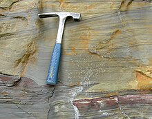
In geology, cross-bedding, also known as cross-stratification, is layering within a stratum and at an angle to the main bedding plane. The sedimentary structures which result are roughly horizontal units composed of inclined layers. The original depositional layering is tilted, such tilting not being the result of post-depositional deformation. Cross-beds or "sets" are the groups of inclined layers, which are known as cross-strata.

<span class="mw-page-title-main">Ripple marks</span> Wave structures created in sediments by bottom current

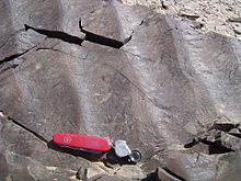
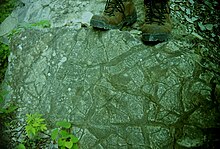
In geology, ripple marks are sedimentary structures and indicate agitation by water or wind.

<span class="mw-page-title-main">Depositional environment</span> Processes associated with the deposition of a particular type of sediment

In geology, depositional environment or sedimentary environment describes the combination of physical, chemical, and biological processes associated with the deposition of a particular type of sediment and, therefore, the rock types that will be formed after lithification, if the sediment is preserved in the rock record. In most cases, the environments associated with particular rock types or associations of rock types can be matched to existing analogues. However, the further back in geological time sediments were deposited, the more likely that direct modern analogues are not available.

<span class="mw-page-title-main">Antidune</span>

An antidune is a bedform found in fluvial and other channeled environments. Antidunes occur in supercritical flow, meaning that the Froude number is greater than 1.0 or the flow velocity exceeds the wave velocity; this is also known as upper flow regime. In antidunes, sediment is deposited on the upstream (stoss) side and eroded from the downstream (lee) side, opposite lower flow regime bedforms. As a result, antidunes migrate in an upstream direction, counter to the current flow. Antidunes are called in-phase bedforms, meaning that the water surface elevation mimics the bed elevation; this is due to the supercritical flow regime. Antidune bedforms evolve rapidly, growing in amplitude as they migrate upstream. The resultant wave at the water's surface also increases in amplitude. When that wave becomes unstable, breaks and washes downstream, much of the antidune bedform may be destroyed.

<span class="mw-page-title-main">Hummocky cross-stratification</span>

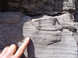
Hummocky cross-stratification is a type of sedimentary structure found in sandstones. It is a form of cross-bedding usually formed by the action of large storms, such as hurricanes. It takes the form of a series of "smile"-like shapes, crosscutting each other. It is only formed at a depth of water below fair-weather wave base and above storm-weather wave base. They are not related to "hummocks" except in shape.

<span class="mw-page-title-main">Wave-formed ripple</span>

In sedimentology, wave-formed ripples or wave-formed ripple marks are a feature of sediments and dunes. These ripple marks are often characterised by symmetric cross sections and long relatively straight crests, which may commonly bifurcate. Commonly, these crests can be truncated by subsequent flows. Their wavelength (periodicity) depends on the sediment grain size, water depth and water-particle orbits in the waves. On tidal flats the pattern of wave-formed ripples may be complicated, as a product of changing depth and wind and tidal runoff directions. Symmetrical ripples are commonly found in shallow waters. Beaches are a good place to find these ripples.

<span class="mw-page-title-main">Bedform</span> Geological feature resulting from the movement of bed material by fluid flow

A bedform is a geological feature that develops at the interface of fluid and a moveable bed, the result of bed material being moved by fluid flow. Examples include ripples and dunes on the bed of a river. Bedforms are often preserved in the rock record as a result of being present in a depositional setting. Bedforms are often characteristic to the flow parameters, and may be used to infer flow depth and velocity, and therefore the Froude number.

The Triassic Lockatong Formation is a mapped bedrock unit in Pennsylvania, New Jersey, and New York. It is named after the Lockatong Creek in Hunterdon County, New Jersey.

<span class="mw-page-title-main">Lamination (geology)</span> Thin layers present in sedimentary rock

In geology, lamination is a small-scale sequence of fine layers that occurs in sedimentary rocks. Laminae are normally smaller and less pronounced than bedding. Lamination is often regarded as planar structures one centimetre or less in thickness, whereas bedding layers are greater than one centimetre. However, structures from several millimetres to many centimetres have been described as laminae. A single sedimentary rock can have both laminae and beds.

<span class="mw-page-title-main">Contourite</span> Type of sedimentary deposit

A contourite is a sedimentary deposit commonly formed on continental rise to lower slope settings, although they may occur anywhere that is below storm wave base. Countourites are produced by thermohaline-induced deepwater bottom currents and may be influenced by wind or tidal forces. The geomorphology of contourite deposits is mainly influenced by the deepwater bottom-current velocity, sediment supply, and seafloor topography.

<span class="mw-page-title-main">Paleocurrent</span> Geological indicator of water flow

A paleocurrent or paleocurrent indicator is a geological feature that helps one determine the direction of flowing water in the geologic past. This is an invaluable tool in the reconstruction of ancient depositional environments.

<span class="mw-page-title-main">Parting lineation</span>

Parting lineation is a subtle sedimentary structure in which sand grains are aligned in parallel lines or grooves on the surface of a body of sand. The orientation of the lineation is used as a paleocurrent indicator, although the precise flow direction is often indeterminable. They are also the primary indicator of the lower part of the upper flow regime bedform.

<span class="mw-page-title-main">Shallow water marine environment</span>

Shallow water marine environment refers to the area between the shore and deeper water, such as a reef wall or a shelf break. This environment is characterized by oceanic, geological and biological conditions, as described below. The water in this environment is shallow and clear, allowing the formation of different sedimentary structures, carbonate rocks, coral reefs, and allowing certain organisms to survive and become fossils.

References

  1. 1 2 3 4 5 6 7 8 Jordan, Thomas H.; Grotzinger, John P. (2012). The Essential Earth (2nd ed.). New York: W.H. Freeman. ISBN   9781429255240. OCLC   798410008.
    • AILSA ALLABY and MICHAEL ALLABY. "sediment." A Dictionary of Earth Sciences. 1999. Encyclopedia.com. 8 Nov. 2010 <http://www.encyclopedia.com>.
  2. Boggs, Sam jr, 2006 Principles of Sedimentology and Stratigraphy, Patrick Lynch, Principles of Sedimentology and Stratigraphy, Pearson Prentice Hall, Upper Saddle River, NJ. Ed 4, p. 83-84
  3. AILSA ALLABY and MICHAEL ALLABY. "antidune." A Dictionary of Earth Sciences. 1999. Encyclopedia.com. 8 Nov. 2010 <http://www.encyclopedia.com>. B
  4. http://jsedres.geoscienceworld.org/cgi/content/abstract/35/4/922 C
  5. Jackson, Julia A., ed. (1997). "bedding-plane sag". Glossary of geology (Fourth ed.). Alexandria, Virginia: American Geological Institute. ISBN   0922152349.
  6. Tucker, Maurice E. (2011). Sedimentary rocks in the field : a practical guide (4th ed.). Chichester, West Sussex: Wiley-Blackwell. p. 160. ISBN   9780470689165.
  7. Jackson 1997, fluid escape structure.

Further reading