Sedimentary rocks are types of rock that are formed by the accumulation or deposition of mineral or organic particles at Earth's surface, followed by cementation. Sedimentation is the collective name for processes that cause these particles to settle in place. The particles that form a sedimentary rock are called sediment, and may be composed of geological detritus (minerals) or biological detritus. The geological detritus originated from weathering and erosion of existing rocks, or from the solidification of molten lava blobs erupted by volcanoes. The geological detritus is transported to the place of deposition by water, wind, ice or mass movement, which are called agents of denudation. Biological detritus was formed by bodies and parts of dead aquatic organisms, as well as their fecal mass, suspended in water and slowly piling up on the floor of water bodies. Sedimentation may also occur as dissolved minerals precipitate from water solution.

Deposition is the geological process in which sediments, soil and rocks are added to a landform or landmass. Wind, ice, water, and gravity transport previously weathered surface material, which, at the loss of enough kinetic energy in the fluid, is deposited, building up layers of sediment.

The geology of the Zion and Kolob canyons area includes nine known exposed formations, all visible in Zion National Park in the U.S. state of Utah. Together, these formations represent about 150 million years of mostly Mesozoic-aged sedimentation in that part of North America. Part of a super-sequence of rock units called the Grand Staircase, the formations exposed in the Zion and Kolob area were deposited in several different environments that range from the warm shallow seas of the Kaibab and Moenkopi formations, streams and lakes of the Chinle, Moenave, and Kayenta formations to the large deserts of the Navajo and Temple Cap formations and dry near shore environments of the Carmel Formation.

A turbidite is the geologic deposit of a turbidity current, which is a type of amalgamation of fluidal and sediment gravity flow responsible for distributing vast amounts of clastic sediment into the deep ocean.
Tempestites are storm deposits that can be recognized throughout the geologic record. They are studied in the scientific disciplines of sedimentary geology and paleotempestology. The deposits derive their meaning from the word tempest, a violent storm. Tempestites are preserved within a multitude of sedimentary environments including delta systems, estuarian systems, coastal environments, deep sea environments, and fresh water lacustrine environments. Tempesites most often form in wave-dominated delta systems and preserve, within the sedimentary record, evidence of events and processes below fair weather wave base and above storm weather wave base. They are commonly characterized by hummocky cross-stratified beds that have an erosive base, and can form under combined flow regimes. This erosive base is often seen in the form of gutter casts.
A way up structure, way up criterion, or geopetal indicator is a characteristic relationship observed in a sedimentary or volcanic rock, or sequence of rocks, that makes it possible to determine whether they are the right way up or have been overturned by subsequent deformation. This technique is particularly important in areas affected by thrusting and where there is a lack of other indications of the relative ages of beds within the sequence, such as in the Precambrian where fossils are rare.
In geology, the term Torridonian is the informal name for the Torridonian Group, a series of Mesoproterozoic to Neoproterozoic arenaceous and argillaceous sedimentary rocks, which occur extensively in the Northwest Highlands of Scotland. The strata of the Torridonian Group are particularly well exposed in the district of upper Loch Torridon, a circumstance which suggested the name Torridon Sandstone, first applied to these rocks by James Nicol. Stratigraphically, they lie unconformably on gneisses of the Lewisian complex and their outcrop extent is restricted to the Hebridean Terrane.

In geology, cross-bedding, also known as cross-stratification, is layering within a stratum and at an angle to the main bedding plane. The sedimentary structures which result are roughly horizontal units composed of inclined layers. The original depositional layering is tilted, such tilting not being the result of post-depositional deformation. Cross-beds or "sets" are the groups of inclined layers, which are known as cross-strata.

In geology, ripple marks are sedimentary structures and indicate agitation by water or wind.

Sole marks are sedimentary structures found on the bases of certain strata, that indicate small-scale grooves or irregularities. This usually occurs at the interface of two differing lithologies and/or grain sizes. They are commonly preserved as casts of these indents on the bottom of the overlying bed. This is similar to casts and molds in fossil preservation. Occurring as they do only at the bottom of beds, and their distinctive shapes, they can make useful way up structures and paleocurrent indicators.

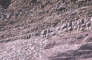
In geology, a bed is a layer of sediment, sedimentary rock, or volcanic rock "bounded above and below by more or less well-defined bedding surfaces". Specifically in sedimentology, a bed can be defined in one of two major ways. First, Campbell and Reineck and Singh use the term bed to refer to a thickness-independent layer comprising a coherent layer of sedimentary rock, sediment, or pyroclastic material bounded above and below by surfaces known as bedding planes. By this definition of bed, laminae are small beds that constitute the smallest (visible) layers of a hierarchical succession and often, but not always, internally comprise a bed.

In geology, depositional environment or sedimentary environment describes the combination of physical, chemical, and biological processes associated with the deposition of a particular type of sediment and, therefore, the rock types that will be formed after lithification, if the sediment is preserved in the rock record. In most cases, the environments associated with particular rock types or associations of rock types can be matched to existing analogues. However, the further back in geological time sediments were deposited, the more likely that direct modern analogues are not available.
Sedimentary structures include all kinds of features in sediments and sedimentary rocks, formed at the time of deposition.

An antidune is a bedform found in fluvial and other channeled environments. Antidunes occur in supercritical flow, meaning that the Froude number is greater than 1.0 or the flow velocity exceeds the wave velocity; this is also known as upper flow regime. In antidunes, sediment is deposited on the upstream (stoss) side and eroded from the downstream (lee) side, opposite lower flow regime bedforms. As a result, antidunes migrate in an upstream direction, counter to the current flow. Antidunes are called in-phase bedforms, meaning that the water surface elevation mimics the bed elevation; this is due to the supercritical flow regime. Antidune bedforms evolve rapidly, growing in amplitude as they migrate upstream. The resultant wave at the water's surface also increases in amplitude. When that wave becomes unstable, breaks and washes downstream, much of the antidune bedform may be destroyed.

Flaser beds are a sedimentary, bi-directional, bedding pattern created when a sediment is exposed to intermittent flows, leading to alternating sand and mud layers. While flaser beds typically form in tidal environments, they can (rarely) form in fluvial conditions - on point bars or in ephemeral streams, or also in deep water environments when turbiditic sediments are reworked by seasonal bottom-currents. Individual sand ripples are created, which are later infilled by mud during quieter flow periods. These mud drapes are typically a minor constituent of the deposit; they can consolidate within three hours, protecting the underlying layer from erosion. Flaser bedding typically forms in high-energy environments.
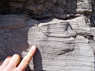
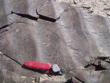
Hummocky cross-stratification is a type of sedimentary structure found in sandstones. It is a form of cross-bedding usually formed by the action of large storms, such as hurricanes. It takes the form of a series of "smile"-like shapes, crosscutting each other. It is only formed at a depth of water below fair-weather wave base and above storm-weather wave base. They are not related to "hummocks" except in shape.

Parting lineation is a subtle sedimentary structure in which sand grains are aligned in parallel lines or grooves on the surface of a body of sand. The orientation of the lineation is used as a paleocurrent indicator, although the precise flow direction is often indeterminable. They are also the primary indicator of the lower part of the upper flow regime bedform.
Heterolithic bedding is a sedimentary structure made up of interbedded deposits of sand and mud. It is formed mainly in tidal flats but can also be formed in glacial environments. Examples from fluvial environments have been documented but are rare. Heterolithic bedding forms in response to alternations in sediment supply and tidal velocity. The fluctuations result in the interbedded layers of sand and mud. The rippled sand layer is formed during high tidal currents, while the mud is deposited during slack tide periods. The three main types of heterolithic bedding are flaser, wavy, and lenticular. Starved ripples and cross bedding with flasers can also be considered forms of heterolithic bedding. Differentiating of these various types of heterolithic bedding is based on the relative volume of mud and sand. This key determining factor is controlled by the timing, and duration of both the high tide, and slack tide depositional periods.

Porcupine Gorge is a gorge on Galah Creek in Porcupine, Shire of Flinders in North West Queensland, Australia. It is a protected area within the Porcupine Gorge National Park. Access to the gorge and national park is via the Kennedy Development Road.

Glaciofluvial deposits or Glacio-fluvial sediments consist of boulders, gravel, sand, silt and clay from ice sheets or glaciers. They are transported, sorted and deposited by streams of water. The deposits are formed beside, below or downstream from the ice. They include kames, kame terraces and eskers formed in ice contact and outwash fans and outwash plains below the ice margin. Typically the outwash sediment is carried by fast and turbulent fluvio-glacial meltwater streams, but occasionally it is carried by catastrophic outburst floods. Larger elements such as boulders and gravel are deposited nearer to the ice margin, while finer elements are carried farther, sometimes into lakes or the ocean. The sediments are sorted by fluvial processes. They differ from glacial till, which is moved and deposited by the ice of the glacier, and is unsorted.