Cross-bedding

Last updated
Cross-bedding of sandstone near Mt. Carmel road, Zion Canyon, indicating wind action and sand dune formation had occurred prior to formation of the rock. Cross-bedding Of Sandstone Near Mt Carmel Road Zion Canyon Utah.jpg
Cross-bedding of sandstone near Mt. Carmel road, Zion Canyon, indicating wind action and sand dune formation had occurred prior to formation of the rock.
Cross-bedding in a sandstone dome in the Canyons of the Escalante. DryForkDome.jpg
Cross-bedding in a sandstone dome in the Canyons of the Escalante.
Sand dune cross-beds can be large, such as in the Jurassic-age erg deposits of Navajo Sandstone in Canyonlands National Park. Aztec Butte shown here Outcrop of Navajo Sandstone on the Island in the Sky District of Canyonlands, June 2005.jpg
Sand dune cross-beds can be large, such as in the Jurassic-age erg deposits of Navajo Sandstone in Canyonlands National Park. Aztec Butte shown here
Formation of cross-stratification Formation of cross-stratification.png
Formation of cross-stratification
Schematic of eolian cross-bedding Formation of cross-bedding.jpg
Schematic of eolian cross-bedding
Close up of cross-bedding and scour, Logan Formation, Ohio Logan Formation Cross Bedding Scour.jpg
Close up of cross-bedding and scour, Logan Formation, Ohio
Tabular cross-bedding in the Navajo Sandstone in Zion National Park Tabular xbed mcr2.JPG
Tabular cross-bedding in the Navajo Sandstone in Zion National Park
Tabular cross-bedding in the South Bar Formation in Nova Scotia Tabular xbed mcr1.JPG
Tabular cross-bedding in the South Bar Formation in Nova Scotia
Trough cross-bedding in the Lower Cove Formation in Nova Scotia Trough xbed mcr2.jpg
Trough cross-bedding in the Lower Cove Formation in Nova Scotia
Trough cross-bedding in the Waddens Cove Formation in Nova Scotia Trough xbed mcr1.JPG
Trough cross-bedding in the Waddens Cove Formation in Nova Scotia
Animation showing deposition and erosion of cross-beds Cross-bedding.gif
Animation showing deposition and erosion of cross-beds

In geology, cross-bedding, also known as cross-stratification, is layering within a stratum and at an angle to the main bedding plane. The sedimentary structures which result are roughly horizontal units composed of inclined layers. The original depositional layering is tilted, such tilting not being the result of post-depositional deformation. Cross-beds or "sets" are the groups of inclined layers, which are known as cross-strata.

Contents

Cross-bedding forms during deposition on the inclined surfaces of bedforms such as ripples and dunes; it indicates that the depositional environment contained a flowing medium (typically water or wind). Examples of these bedforms are ripples, dunes, anti-dunes, sand waves, hummocks, bars, and delta slopes. [1] Environments in which water movement is fast enough and deep enough to develop large-scale bed forms fall into three natural groupings: rivers, tide-dominated coastal and marine settings. [2]

Significance

Cross-beds can tell geologists much about what an area was like in ancient times. The direction the beds are dipping indicates paleocurrent, the rough direction of sediment transport. The type and condition of sediments can tell geologists the type of environment (rounding, sorting, composition...). Studying modern analogs allows geologists to draw conclusions about ancient environments. Paleocurrent can be determined by seeing a cross-section of a set of cross-beds. However, to get a true reading, the axis of the beds must be visible. It is also difficult to distinguish between the cross-beds of a dune and the cross-beds of an antidune. (Dunes dip downstream while antidunes dip upstream.) [1]

The direction of motion of the cross-beds can show ancient flow or wind directions (called paleocurrents). The foresets are deposited at the angle of repose (~34 degrees from the horizontal), so geologists are able to measure dip direction of the cross-bedded sediments and calculate the paleoflow direction. However, most cross-beds are not tabular, they are troughs[ citation needed ]. Since troughs can give a 180 degree variation of the dip of foresets, false paleocurrents can be taken by blindly measuring foresets. In this case, true paleocurrent direction is determined by the axis of the trough. Paleocurrent direction is important in reconstructing past climate and drainage patterns: sand dunes preserve the prevalent wind directions, and current ripples show the direction rivers were moving.
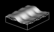
Formation

Cross-bedding is formed by the downstream migration of bedforms such as ripples or dunes [3] in a flowing fluid. The fluid flow causes sand grains to saltate up the stoss (upstream) side of the bedform and collect at the peak until the angle of repose is reached. At this point, the crest of granular material has grown too large and will be overcome by the force of the moving water, falling down the lee(downstream) side of the dune. Repeated avalanches will eventually form the sedimentary structure known as cross-bedding, with the structure dipping in the direction of the paleocurrent.

The sediment that goes on to form cross-stratification is generally sorted before and during deposition on the "lee" side of the dune, allowing cross-strata to be recognized in rocks and sediment deposits. [4]

The angle and direction of cross-beds are generally fairly consistent. Individual cross-beds can range in thickness from just a few tens of centimeters, up to hundreds of feet or more depending upon the depositional environment and the size of the bedform. [5] Cross-bedding can form in any environment in which a fluid flows over a bed with mobile material. It is most common in stream deposits (consisting of sand and gravel), tidal areas, and in aeolian dunes.

Internal sorting patterns

Cross-bedded sediments are recognized in the field by the many layers of "foresets", which are the series of layers that form on the downstream or lee side of the bedform (ripple or dune). These foresets are individually differentiable because of small-scale separation between layers of material of different sizes and densities.

Cross-bedding can also be recognized by truncations in sets of ripple foresets, where previously-existing stream deposits are eroded by a later flood, and new bedforms are deposited in the scoured area.

Geometries

Cross-bedding can be subdivided according to the geometry of the sets and cross-strata into subcategories. The most commonly described types are tabular cross-bedding and trough cross-bedding. Tabular cross-bedding, or planar bedding consists of cross-bedded units that are extensive horizontally relative to the set thickness and that have essentially planar bounding surfaces. [3] Trough cross-bedding, on the other hand, consists of cross-bedded units in which the bounding surfaces are curved, and hence limited in horizontal extent. [3]

Tabular (planar) cross-beds

Tabular (planar) cross-beds consist of cross-bedded units that are large in horizontal extent relative to set thickness and that have essentially planar bounding surfaces. The foreset laminae of tabular cross-beds are curved so as to become tangential to the basal surface. [3]

Tabular cross-bedding is formed mainly by migration of large-scale, straight-crested ripples and dunes. It forms during lower-flow regimes. Individual beds range in thickness from a few tens of centimeters to a meter or more, but bed thickness down to 10 centimeters has been observed. [6] Where the set height is less than 6 centimeters and the cross-stratification layers are only a few millimeters thick, the term cross-lamination is used, rather than cross-bedding. Cross-bed sets occur typically in granular sediments, especially sandstone, and indicate that sediments were deposited as ripples or dunes, which advanced due to a water or air current. [7]

Trough cross-beds

Cross-beds are layers of sediment that are inclined relative to the base and top of the bed they are associated with. Cross-beds can tell modern geologists many things about ancient environments such as- depositional environment, the direction of sediment transport (paleocurrent) and even environmental conditions at the time of deposition. Typically, units in the rock record are referred to as beds, while the constituent layers that make up the bed are referred to as laminae, when they are less than 1 cm thick and strata when they are greater than 1 cm in thickness. [1] Cross-beds are angled relative to either the base or the top of the surrounding beds. As opposed to angled beds, cross-beds are deposited at an angle rather than deposited horizontally and deformed later on. [8] Trough cross-beds have lower surfaces which are curved or scoop shaped and truncate the underlying beds. The foreset beds are also curved and merge tangentially with the lower surface. They are associated with sand dune migration. [9]

Sediment

The shape of the grains and the sorting and composition of sediment can provide additional information on the history of cross-beds. Roundness of the grains, limited variation in grain size, and high quartz contents are generally attributed to longer histories of weathering and sediment transport. For example: well-rounded, and well-sorted sand that is mostly composed of quartz grains is commonly found in beach environments, far from the source of the sediment. Poorly sorted and angular sediment that is composed of a diversity of minerals is more commonly found in rivers, near the source of the sediment. [8] However, older sedimentary deposits are frequently eroded and re-mobilized. Thus, a river may well erode an older formation of well-rounded, well-sorted beach sands of nearly pure quartz.

Environments

Rivers

Flows are characterized by climate (snows, rain, and ice melting) and gradient. Discharge variations measured on a variety of time scales can change water depth, and speed. Some rivers can be characterized by a predictable seasonably controlled hydrograph (reflecting snow melt or rainy season). Others are dominated by durational variations characteristic of alpine glaciers run-off or random storm events, which produce flashy discharge. Few rivers have a long term record of steady flow in the rock record. [2]

Bed forms are relatively dynamic sediment storage bodies with response times that are short relative to major changes in flow characteristics. Large scale bed forms are periodic and occur in the channel (scaled to depth). Their presence and morphologic variability have been related to flow strength expressed as mean velocity or shear stress. [2]

In a fluvial environment, the water in a stream loses energy and its ability transport sediment. The sediment "falls" out of the water and is deposited along a point bar. Over time the river may dry up or avulse and the point bar may be preserved as cross-bedding.

Tide-dominated

Tide dominated environments include:

In general, the greater the tidal range the greater the maximum flow strength. [2] Cross-stratification in tidal-dominated areas can lead to the formation of Herringbone cross-stratification.

Although the flow direction reverses regularly, the flow patterns of flood on ebb currents commonly do not coincide. Consequently, the water and transport sediment may follow a roundabout route in and out of the estuary. This leads to spatially varied systems where some parts of the estuary are flood dominated and other parts are ebb dominated. The temporal and spatial variability of flow and sediment transport, coupled with regular fluctuating water levels creates a variety of bed form morphology. [2]

Shallow marine

Large scale bed forms occur on shallow, terrigenous or carbonate clastic continental shelves and epicontinental platforms which are affected by strong geostrophic currents, occasional storm surges and/or tide currents. [2]

Aeolian

In an aeolian environment, cross-beds often exhibit inverse grading due to their deposition by grain flows. Winds blow sediment along the ground until they start to accumulate. The side that the accumulation occurs on is called the windward side. As it continues to build, some sediment falls over the end. This side is called the leeward side. Grain flows occur when the windward side accumulates too much sediment, the angle of repose is reached and the sediment tumbles down. As more sediment piles on top the weight causes the underlying sediment to cement together and form cross-beds. [8]

Related Research Articles

Sedimentary rock Rock formed by the deposition and subsequent cementation of material

Sedimentary rocks are types of rock that are formed by the accumulation or deposition of mineral or organic particles at Earth's surface, followed by cementation. Sedimentation is the collective name for processes that cause these particles to settle in place. The particles that form a sedimentary rock are called sediment, and may be composed of geological detritus (minerals) or biological detritus. The geological detritus originated from weathering and erosion of existing rocks, or from the solidification of molten lava blobs erupted by volcanoes. The geological detritus is transported to the place of deposition by water, wind, ice or mass movement, which are called agents of denudation. Biological detritus was formed by bodies and parts of dead aquatic organisms, as well as their fecal mass, suspended in water and slowly piling up on the floor of water bodies. Sedimentation may also occur as dissolved minerals precipitate from water solution.

Deposition (geology) Geological process in which sediments, soil and rocks are added to a landform or landmass

Deposition is the geological process in which sediments, soil and rocks are added to a landform or landmass. Wind, ice, water, and gravity transport previously weathered surface material, which, at the loss of enough kinetic energy in the fluid, is deposited, building up layers of sediment.

Tempestite

Tempestites are storm deposits that can be recognized throughout the geologic record. They are studied in the scientific disciplines of sedimentary geology and paleotempestology. The deposits derive their meaning from the word tempest, a violent storm. Tempestites are preserved within a multitude of sedimentary environments including delta systems, estuarian systems, coastal environments, deep sea environments, and fresh water lacustrine environments. Tempesites most often form in wave-dominated delta systems and preserve, within the sedimentary record, evidence of events and processes below fair weather wave base and above storm weather wave base. They are commonly characterized by hummocky cross-stratified beds that have an erosive base, and can form under combined flow regimes. This erosive base is often seen in the form of gutter casts.

A way up structure, way up criterion, or geopetal indicator is a characteristic relationship observed in a sedimentary or volcanic rock, or sequence of rocks, that makes it possible to determine whether they are the right way up or have been overturned by subsequent deformation. This technique is particularly important in areas affected by thrusting and where there is a lack of other indications of the relative ages of beds within the sequence, such as in the Precambrian where fossils are rare.

Torridon Group

In geology, the term Torridonian is the informal name for the Torridonian Group, a series of Mesoproterozoic to Neoproterozoic arenaceous and argillaceous sedimentary rocks, which occur extensively in the Northwest Highlands of Scotland. The strata of the Torridonian Group are particularly well exposed in the district of upper Loch Torridon, a circumstance which suggested the name Torridon Sandstone, first applied to these rocks by James Nicol. Stratigraphically, they lie unconformably on gneisses of the Lewisian complex and their outcrop extent is restricted to the Hebridean Terrane.

Ripple marks Wave structures created in sediments by bottom current

In geology, ripple marks are sedimentary structures and indicate agitation by water or wind.

Bed (geology)

In geology, a bed is a layer of sediment, sedimentary rock, or pyroclastic material "bounded above and below by more or less well-defined bedding surfaces". Specifically in sedimentology, a bed can be defined in one of two major ways. First, Campbell and Reineck and Singh use the term bed to refer to a thickness-independent layer comprising a coherent layer of sedimentary rock, sediment, or pyroclastic material bounded above and below by surfaces known as bedding planes. By this definition of bed, laminae are small beds that constitute the smallest (visible) layers of a hierarchical succession and often, but not always, internally comprise a bed.

The Tumblagooda Sandstone is a geological formation deposited during the Silurian or Ordovician periods, between four and five hundred million years ago, and is now exposed on the west coast of Australia in river and coastal gorges near the tourist town of Kalbarri, Kalbarri National Park and the Murchison River gorge, straddling the boundary of the Carnarvon and Perth basins. Visible trackways are interpreted by some to be the earliest evidence of fully terrestrial animals.

Sedimentary structures Geologic structures formed during sediment deposition

Sedimentary structures include all kinds of features in sediments and sedimentary rocks, formed at the time of deposition.

Antidune

An antidune is a bedform found in fluvial and other channeled environments. Antidunes occur in supercritical flow, meaning that the Froude number is greater than 1.0 or the flow velocity exceeds the wave velocity; this is also known as upper flow regime. In antidunes, sediment is deposited on the upstream (stoss) side and eroded from the downstream (lee) side, opposite lower flow regime bedforms. As a result, antidunes migrate in an upstream direction, counter to the current flow. Antidunes are called in-phase bedforms, meaning that the water surface elevation mimics the bed elevation; this is due to the supercritical flow regime. Antidune bedforms evolve rapidly, growing in amplitude as they migrate upstream. The resultant wave at the water's surface also increases in amplitude. When that wave becomes unstable, breaks and washes downstream, much of the antidune bedform may be destroyed.

Hummocky cross-stratification

Hummocky cross-stratification is a type of sedimentary structure found in sandstones. It is a form of cross-bedding usually formed by the action of large storms, such as hurricanes. It takes the form of a series of "smile"-like shapes, crosscutting each other. It is only formed at a depth of water below fair-weather wave base and above storm-weather wave base. They are not related to "hummocks" except in shape.

Bedform

A bedform is a feature that develops at the interface of fluid and a moveable bed, the result of bed material being moved by fluid flow. Examples include ripples and dunes on the bed of a river. Bedforms are often preserved in the rock record as a result of being present in a depositional setting. Bedforms are often characteristic to the flow parameters, and may be used to infer flow depth and velocity, and therefore the Froude number.

Contourite Type of sedimentary deposit

A contourite is a sedimentary deposit commonly formed on continental rise to lower slope settings, although they may occur anywhere that is below storm wave base. Countourites are produced by thermohaline-induced deepwater bottom currents and may be influenced by wind or tidal forces. The geomorphology of contourite deposits is mainly influenced by the deepwater bottom-current velocity, sediment supply, and seafloor topography.

Paleocurrent

A paleocurrent or paleocurrent indicator is a geological feature that helps one determine the direction of flowing water in the geologic past. This is an invaluable tool in the reconstruction of ancient depositional environments.

Parting lineation

Parting lineation is a subtle sedimentary structure in which sand grains are aligned in parallel lines or grooves on the surface of a body of sand. The orientation of the lineation is used as a paleocurrent indicator, although the precise flow direction is often indeterminable. They are also the primary indicator of the lower part of the upper flow regime bedform.

Vegetation-induced sedimentary structures (VISS) are primary sedimentary structures formed by the interaction of detrital sediment with in situ plants. VISS provide physical evidence of vegetation's fundamental role in mediating sediment accumulation and erosion in clastic depositional environments. VISS can be broken into seven types, five being hydrodynamic and two being decay-related. The simple hydrodynamic VISS are categorized by centroclinal cross strata, scratch semicircles and upturned beds. The complex hydrodynamic VISS are categorized by coalesced scour fills and scour-and-mound beds. The decay-related VISS are categorized by mudstone-filled hollows and downturned beds.

Heterolithic bedding is a sedimentary structure made up of interbedded deposits of sand and mud. It is formed mainly in tidal flats but can also be formed in glacial environments. Examples from fluvial environments have been documented but are rare. Heterolithic bedding forms in response to alternations in sediment supply and tidal velocity. The fluctuations result in the interbedded layers of sand and mud. The rippled sand layer is formed during high tidal currents, while the mud is deposited during slack tide periods. The three main types of heterolithic bedding are flaser, wavy, and lenticular. Starved ripples and cross bedding with flasers can also be considered forms of heterolithic bedding. Differentiating of these various types of heterolithic bedding is based on the relative volume of mud and sand. This key determining factor is controlled by the timing, and duration of both the high tide, and slack tide depositional periods.

Shallow water marine environment

Shallow water marine environment refers to the area between the shore and deeper water, such as a reef wall or a shelf break. This environment is characterized by oceanic, geological and biological conditions, as described below. The water in this environment is shallow and clear, allowing the formation of different sedimentary structures, carbonate rocks, coral reefs, and allowing certain organisms to survive and become fossils.

Herringbone cross-stratification

Herringbone cross-stratification is a type of sedimentary structure formed in tidal areas, such as tidal flats, where the current periodically flows in the opposite direction.

Porcupine Gorge Gorge in North West Queensland, Australia

Porcupine Gorge is a gorge on Galah Creek in Porcupine, Shire of Flinders in North West Queensland, Australia. It is a protected area within the Porcupine Gorge National Park. Access to the gorge and national park is via the Kennedy Development Road.

References

  1. 1 2 3 Collinson, J.D., Thompson, D.B., 1989, Sedimentary Structures (2nd ed): Academic Division of Unwin Hyman Ltd, Winchester, MA, XXX p.
  2. 1 2 3 4 5 6 Ashley, G. (1990) "Classification of Large-Scale Subaqueous Bedforms: A New Look At An Old Problem." Journal of Sedimentary Petrology. 60.1: 160-172. Print.
  3. 1 2 3 4 Boggs, S., 2006, Principles of Sedimentology and Stratigraphy (4th ed): Pearson Prentice Hall, Upper Saddle River, NJ, XXX p.
  4. Reesink, A.J.H. and Bridge, J.S., 2007 "Influence of superimposed bedforms and flow unsteadiness on formation of cross strata in dunes and unit bars." Sedimentary Geology , 202, 1-2, p. 281-296 doi : 10.1016/j.sedgeo.2007.02.00508/2002.
  5. Bourke, Lawrence, and McGarva, Roddy. "Go With The Flow: Part I Palaeotransport Analysis ." Task Geoscience. N.p., 08/2002. Web. 2 Nov 2010. < "Task Geoscience - the Borehole Image and Dipmeter Experts". Archived from the original on 2010-10-28. Retrieved 2010-12-02.>
  6. Stow, A.V., 2009, Sedimentary rocks in the field. A color guide (3rd ed.) print.
  7. Hurlbut, C. 1976. The Planet We Live On, An Illustrated Encyclopedia of the Earth Sciences. NY: Harry N. Abrams, Inc., Print.
  8. 1 2 3 Middleton, G., 2003, Encyclopedia of Sedimentary Rocks : <MPG Books, Cornwall, GB, XXX p.
  9. McLane, Michael, Sedimentology, Oxford University Press, 1995, pp 95-97 ISBN   0-19-507868-3