Aztec Butte

Last updated
Aztec Butte
Aztec Butte, Canyonlands National Park, Utah.jpg
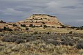
Southeast aspect, seen from Mesa Arch Trail
Highest point
Elevation 6,312 ft (1,924 m) [1]
Prominence 232 ft (71 m) [1]
Parent peak Shaft Benchmark (6,329 ft) [1]
Isolation 1.54 mi (2.48 km) [2]
Coordinates 38°23′51″N109°52′26″W / 38.39751°N 109.873838°W / 38.39751; -109.873838 Coordinates: 38°23′51″N109°52′26″W / 38.39751°N 109.873838°W / 38.39751; -109.873838 [1]
Geography
USA Utah relief location map.svg
Red triangle with thick white border.svg
Aztec Butte
Location of Aztec Butte in Utah
Usa edcp relief location map.png
Red triangle with thick white border.svg
Aztec Butte
Aztec Butte (the United States)
Location Canyonlands National Park
San Juan County, Utah, U.S.
Parent range Colorado Plateau
Topo map USGS Musselman Arch
Geology
Age of rock Jurassic
Type of rock Navajo Sandstone
Climbing
Easiest route class 3 scrambling [2]

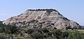
Aztec Butte is a sandstone summit, elevation 6,312 feet (1,924 meters), located in the Island in the Sky District of Canyonlands National Park, in San Juan County, Utah. [3] Aztec Butte is composed of white cross-bedded Navajo Sandstone, which is the remains of wind-borne sand dunes deposited approximately 170 million years ago during the Jurassic Period. It resembles the Pyramid of the Sun in Mexico, which was built by the Aztecs. [4]

Contents

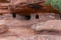
Ancestral Puebloan people traveled to the Island in the Sky area to hunt and gather seeds, then stored their food in stone granaries near the top of Aztec Butte. These well-preserved granaries date to AD 1200–1300. [5] A half-mile hiking trail through flat grassland, followed by a quarter-mile scramble with 200 feet vertical gain, leads to the top of the butte and the granaries. The trailhead is located alongside the road to Upheaval Dome. In addition to Upheaval Dome, other nearby attractions include Mesa Arch which is situated less than 1 mi (1.6 km) to the southeast, Muffin Butte to the south, Green River Overlook to the southwest, and Trail Canyon to the north. Precipitation runoff from Aztec Butte drains to the Green River.

Climate

Spring and fall are the most favorable seasons to visit Aztec Butte. According to the Köppen climate classification system, it is located in a Cold semi-arid climate zone, which is defined by the coldest month having an average mean temperature below −0 °C (32 °F) and at least 50% of the total annual precipitation being received during the spring and summer. This desert climate receives less than 10 inches (250 millimeters) of annual rainfall, and snowfall is generally light during the winter.

Climate data for Island in the Sky Visitor Center, elevation 5,666 ft (1,727 m), 1981-2010 normals, extremes 1981-2019
MonthJanFebMarAprMayJunJulAugSepOctNovDecYear
Record high °F (°C)58.6
(14.8)
69.0
(20.6)
79.8
(26.6)
86.1
(30.1)
98.5
(36.9)
103.9
(39.9)
106.4
(41.3)
101.1
(38.4)
97.9
(36.6)
86.9
(30.5)
71.0
(21.7)
59.2
(15.1)
106.4
(41.3)
Average high °F (°C)38.1
(3.4)
44.1
(6.7)
54.9
(12.7)
63.5
(17.5)
74.2
(23.4)
85.4
(29.7)
91.7
(33.2)
88.7
(31.5)
79.5
(26.4)
65.8
(18.8)
49.7
(9.8)
38.1
(3.4)
64.6
(18.1)
Average low °F (°C)20.8
(−6.2)
25.8
(−3.4)
33.3
(0.7)
40.0
(4.4)
49.5
(9.7)
59.8
(15.4)
66.0
(18.9)
63.9
(17.7)
54.9
(12.7)
42.5
(5.8)
31.1
(−0.5)
21.3
(−5.9)
42.5
(5.8)
Record low °F (°C)−8.0
(−22.2)
−12.4
(−24.7)
10.4
(−12.0)
16.3
(−8.7)
26.0
(−3.3)
28.7
(−1.8)
46.0
(7.8)
50.2
(10.1)
27.6
(−2.4)
9.2
(−12.7)
6.2
(−14.3)
−9.4
(−23.0)
−12.4
(−24.7)
Average precipitation inches (mm)0.53
(13)
0.50
(13)
0.76
(19)
0.72
(18)
0.70
(18)
0.45
(11)
0.93
(24)
1.04
(26)
1.06
(27)
1.30
(33)
0.70
(18)
0.58
(15)
9.27
(235)
Average dew point °F (°C)18.6
(−7.4)
21.8
(−5.7)
23.3
(−4.8)
25.7
(−3.5)
29.5
(−1.4)
32.7
(0.4)
41.2
(5.1)
45.1
(7.3)
37.6
(3.1)
29.5
(−1.4)
23.2
(−4.9)
17.9
(−7.8)
28.9
(−1.7)
Source: PRISM [6]

See also

Related Research Articles

Canyonlands National Park National park in Utah, United States

Canyonlands National Park is an American national park located in southeastern Utah near the town of Moab. The park preserves a colorful landscape eroded into numerous canyons, mesas, and buttes by the Colorado River, the Green River, and their respective tributaries. Legislation creating the park was signed into law by President Lyndon Johnson on September 12, 1964.

Upheaval Dome Geological feature in Utah, United States

Upheaval Dome is an enigmatic geological structure in San Juan County, Utah, United States, that has been variously interpreted as a meteorite impact structure or a salt dome. The structure lies 22 miles (35 km) southwest of the city of Moab, Utah, in the Island in the Sky section of Canyonlands National Park.

Mesa Arch

Mesa Arch is a pothole arch on the eastern edge of the Island in the Sky mesa in Canyonlands National Park in northern San Juan County, Utah, United States. Mesa Arch is a spectacular natural stone arch perched at the edge of a cliff with vast views of canyons, Monster Tower, Washer Woman Arch, Airport Tower, and the La Sal Mountains in the distance. Access is via a relatively easy hiking trail, just a half-mile long from the park road.

Druid Arch

Druid Arch is an iconic 150-foot tall Cedar Mesa Sandstone arch located within the Needles District of Canyonlands National Park, in San Juan County, Utah. It is situated at the head of Elephant Canyon, and precipitation runoff from Druid Arch drains north into the nearby Colorado River via Elephant Canyon. Druid Arch is one of the most popular hiking destinations in the Needles district. A 5.4 mile hike to Druid Arch starts at the Elephant Hill Trailhead, and the final quarter-mile is steep with some scrambling and one ladder. The name comes from its resemblance to the Stonehenge monument in England, which is believed to be a Druid temple. This feature's name was officially adopted in 1963 by the U.S. Board on Geographic Names.

Angel Arch

Angel Arch is the largest natural arch located within Canyonlands National Park, in San Juan County, Utah. Some consider it the most beautiful and spectacular arch in the park, if not the entire canyon country. It is situated in a side canyon of Salt Creek Canyon, in the Needles District of the park. Precipitation runoff from Angel Arch drains north into the nearby Colorado River via Salt Creek. A 29-mile round-trip hike to Angel Arch leads to a viewpoint, and an additional 0.75-mile trail scrambles up into the arch opening. The arch's descriptive name comes from its resemblance to an angel with wings folded, and standing with its back to the arch opening. Before this feature's name was officially adopted in 1963 by the U.S. Board on Geographic Names, it was called Pegasus Arch. The first ascent was made in June 1993, by John Markel and Kevin Chase.

Monster Tower

Monster Tower is a 600-foot (180-meter) tall sandstone tower located in the Island in the Sky District of Canyonlands National Park, in San Juan County, Utah, United States.

Candlestick Tower Rock formation in Utah, United States

Candlestick Tower is a 450-foot-tall (140 m) sandstone butte located in the Island in the Sky District of Canyonlands National Park, in San Juan County, Utah. Its descriptive name comes from its resemblance to a candlestick. Candlestick Tower is composed of Wingate Sandstone, which is the remains of wind-borne sand dunes deposited approximately 200 million years ago in the Late Triassic.

Washer Woman

Washer Woman is a 500-foot (150-meter) tall sandstone arch and tower located in the Island in the Sky District of Canyonlands National Park, in San Juan County, Utah. It is situated 300 feet northwest of the slightly higher Monster Tower. Washer Woman is so named because the feature gives the appearance of a washerwoman bent over a washtub. This geographical feature's name was officially adopted in 1986 by the U.S. Board on Geographic Names after previously having similar names such as Washer-Woman Arch and The Washer Woman. Washer Woman and Monster Tower are an eroded fin composed of Wingate Sandstone, which is the remains of wind-borne sand dunes deposited approximately 200 million years ago in the Late Triassic. Airport Tower is set 1.6 mi (2.6 km) to the east, and Mesa Arch is situated 1.5 mi (2.4 km) to the west. A short hike to Mesa Arch provides the easiest view of Washer Woman. Access to this formation is via the four-wheel drive White Rim Road, which is the other option to see it. The top of this geological formation rises 1,300 feet above the road in approximately one mile. Precipitation runoff from Washer Woman drains southeast into the nearby Colorado River via Buck Canyon.

Airport Tower (Canyonlands)

Airport Tower is a 700-foot (210-meter) tall sandstone butte located in the Island in the Sky District of Canyonlands National Park, in San Juan County, Utah. It is situated 1.64 mile east of Washer Woman, which is a towering arch similar in height. Each are composed of Wingate Sandstone, which is the remains of wind-borne sand dunes deposited approximately 200 million years ago in the Late Triassic. The nearest higher neighbor is Monster Tower, 1.6 mi (2.6 km) to the west, Tiki Tower is one-half mile northwest, and Mesa Arch is situated 3.2 mi (5.1 km) to the west. A short hike to Mesa Arch provides the easiest view of Airport Tower. Access to this tower is via the four-wheel drive White Rim Road, which is another option to see Airport Tower. The top of this geological formation rises 1,400 feet above the road in less than one mile. Precipitation runoff from Airport Tower drains southeast into the nearby Colorado River via Buck and Lathrop Canyons. This geographical feature's name was officially adopted in 1986 by the U.S. Board on Geographic Names. It was so named because the rock formation resembles the appearance of an airport control tower.

Zeus and Moses Rock formations in Utah, United States

Zeus and Moses are a pair of 500-foot-tall (150 m) sandstone formations located in the Island in the Sky District of Canyonlands National Park, in San Juan County, Utah, United States. These rock towers' names refer to Zeus, a god in Greek mythology, and Moses, an important prophet in several religious traditions. Zeus and Moses are composed of Wingate Sandstone, which is the remains of wind-borne sand dunes deposited approximately 200 million years ago in the Late Triassic. This formation is situated in Taylor Canyon, 3 mi (4.8 km) north-northeast of Upheaval Dome. Access to the towers is via the four-wheel-drive White Rim Road, and a spur road into Taylor Canyon. The top of this geological formation rises 900 feet above the canyon floor at road's end, approximately one-half mile away. Precipitation runoff from Zeus and Moses drains into the nearby Green River via Taylor Canyon.

Buttes of the Cross

Buttes of the Cross is two sandstone summits located in the northern reach of Glen Canyon National Recreation Area, in Wayne County of Utah, United States. The larger and higher south butte reaches an elevation of 5,642 feet, whereas the north butte rises to 5,569 feet, with approximately 0.6 mile separation between them. When viewed from the north-northeast near Labyrinth Canyon, they align to form the shape of a cross, creating the appearance of a single butte. The name "Butte of the Cross" was first applied by John Wesley Powell during the Powell Geographic Expedition of 1869. A few miles further down the Green River, Powell finds that this geographical feature is two buttes when viewed from the east, so it was renamed Buttes of the Cross. Buttes of the Cross towers over 1,400 feet above its surrounding terrain. It is situated 6.8 miles west of Candlestick Tower, and one-half mile outside the boundary of Canyonlands National Park.

Junction Butte

Junction Butte is a 6,400-foot (2,000-meter) elevation summit located in the Island in the Sky District of Canyonlands National Park, in San Juan County, Utah. It is set about one mile south of the southern tip of Island in the Sky. A short hike to Grand View Point provides a view of Junction Butte. Access to this butte is via the four-wheel drive White Rim Road, which is another option to view Junction Butte. Topographic relief is significant as the top of this geological formation rises 1,400 feet above the road in less than one mile. Precipitation runoff from Junction Butte drains east into the nearby Colorado River, and west into nearby Green River. Junction Butte is situated north of the junction of these two major rivers.

Ekker Butte

Ekker Butte is a 6,260-foot (1,910-meter) elevation summit located in the northern reach of Glen Canyon National Recreation Area, in Wayne County of Utah, United States. It is situated seven miles southeast of Buttes of the Cross, six miles northeast of Elaterite Butte, and less than two miles outside the boundary of Canyonlands National Park, where it towers over 1,400 feet above the surrounding terrain. Distant views of this remote butte can be seen from the Grand View Point and Green River Overlooks at Island in the Sky of Canyonlands National Park. This geological landmark is named for the pioneering Art Ekker family which operated the nearby Robbers Roost Ranch and grazed cattle on land adjacent to the nearby Maze. Arthur Benjamin Ekker (1911–1978) took Robert Redford on a tour of nearby Robbers Roost, the hideout of outlaw Butch Cassidy and the Wild Bunch.

Elaterite Butte

Elaterite Butte is a 6,552-foot (1,997-meter) elevation summit located in The Maze District of Canyonlands National Park, in Wayne County, Utah. Elaterite Butte is situated 6 mi (9.7 km) southwest of Ekker Butte, and the Maze Overlook is situated 2.5 mi (4.0 km) to the northeast. Elaterite Butte is composed of hard, fine-grained Wingate Sandstone, which is the remains of wind-borne sand dunes deposited approximately 200 million years ago in the Late Triassic. This Wingate sandstone overlays a 432-foot thick layer of the softer Chinle Formation. The top of this geological formation rises over 1,400 feet above Elaterite Basin. The butte and basin are named for elaterite, which is a dark brown, tar-like, elastic mineral resin that seeps from parts of the nearby White Rim Sandstone. Access to the remote butte is via a four-wheel drive road in Elaterite Basin. Precipitation runoff from Elaterite Butte drains into the nearby Green River, which in turn is within the Colorado River drainage basin.

Chip and Dale Towers

Chip and Dale Towers are two 300-foot (91-meter) tall sandstone towers located in the Island in the Sky District of Canyonlands National Park, in San Juan County, Utah. Dale Tower rises to an elevation of 5,620 feet, whereas the lower Chip Tower is 5,420-feet. Airport Tower is set 2.5 mi (4.0 km) to the southwest, and Dead Horse Point State Park overlook is situated 4.5 mi (7.2 km) to the north-northeast. Chip and Dale Towers are an eroded fin composed of hard, fine-grained Wingate Sandstone, which is the remains of wind-borne sand dunes deposited approximately 200 million years ago in the Late Triassic. This Wingate Sandstone overlays a softer layer of the Chinle Formation. Access to the towers is via the four-wheel drive White Rim Road, and a scramble to reach the base. The top of the towers rise over 1,000 feet above the road in approximately one-half mile. Precipitation runoff from Chip and Dale Towers drains east to the nearby Colorado River.

Sixshooter Peaks

The Sixshooter Peaks are two iconic sandstone summits located in Bears Ears National Monument, in San Juan County of Utah, United States. The larger and higher North Sixshooter Peak rises to an elevation of 6,379 feet, whereas South Sixshooter Peak rises to 6,154 feet, with approximately 1.5 mile separation between the two. These buttes tower nearly 1,400 feet above the surrounding terrain, and are historic landmarks visible from State Route 211 between Newspaper Rock and the Needles District of Canyonlands National Park. They are situated 1.5 mile outside the boundary of the park, and four miles northwest of Bridger Jack Butte. Variant names for the peaks include "North Six-Shooter Peak", "South Six-shooter Peak", "Six Shooter Peaks", and "Six-shooter Peak". They are so named because of their resemblance to a pair of revolvers pointing skyward.

Bridger Jack Butte

The Bridger Jack Butte is a sandstone summit located in Bears Ears National Monument, in San Juan County of Utah, United States. This butte, which is set at the northern tip of namesake Bridger Jack Mesa, and above the confluence of Indian and Lavender Creeks, rises to an elevation of 5,890 feet, and towers over 700 feet above the surrounding terrain and floor of Lavender Canyon to its west. This landmark is situated four miles southeast of Sixshooter Peaks, and is visible from State Route 211 between Newspaper Rock and the Needles District of Canyonlands National Park. "Bridger Jack" was a Paiute medicine man.

Smithsonian Butte

Smithsonian Butte is a 6,780-foot (2,070 m) elevation summit located in the Canaan Mountain Wilderness of Washington County in southwest Utah, United States.

Eagle Crags

Eagle Crags is a 6,380-foot (1,940 m) elevation summit located in the Canaan Mountain Wilderness of Washington County in southwest Utah, United States.

Tiki Tower

Tiki Tower is a thin 300-foot (91-meter) tall sandstone pinnacle located in the Airport Tower/Monster Tower/Washer Woman area of the Island in the Sky District of Canyonlands National Park, in San Juan County, Utah. It is situated one-half mile northwest of Airport Tower, and is composed of Wingate Sandstone, which is the remains of wind-borne sand dunes deposited approximately 200 million years ago in the Late Triassic. Access to this tower is via the four-wheel-drive White Rim Road. The top of this spire rises 1,100 feet above the road in a little more than one mile. Precipitation runoff from Tiki Tower drains southeast into the nearby Colorado River via Buck and Lathrop Canyons. The first ascent of Tiki Tower was made in November 1991 by Jeff Widen and Mitch Allen, via Brave Little Toaster, with Fred Lifton and Paul Frank working the first pitch.

References

  1. 1 2 3 4 "Aztec Butte, Utah". Peakbagger.com. Retrieved 2020-10-12.
  2. 1 2 "Aztec Butte - 6,312' UT". listsofjohn.com. Retrieved 2020-09-19.
  3. "Aztec Butte". Geographic Names Information System . United States Geological Survey . Retrieved 2020-10-12.
  4. Stewart M. Green, Best Easy Day Hikes Moab, Rowman & Littlefield Publishing Group, 2020, pake 115.
  5. Greg Witt, 50 Best Short Hikes: Utah's National Parks, 2nd ed., 2014, Wilderness Press, page 99.
  6. "PRISM Climate Group, Oregon State University". Archived from the original on August 25, 2019. Retrieved February 19, 2019.