Logan Formation

Last updated
Logan Formation
Stratigraphic range: Lower Carboniferous (early Osagean)
LoganFormationWooster.JPG
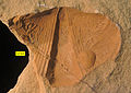
Logan Formation exposed in Wooster, Ohio.
TypeSedimentary
Unit of Waverly Group
Sub-unitsBerne, Byer, Allenville, Vinton
Underlies Maxville Limestone, Pottsville Group, and Rushville Shale
Overlies Cuyahoga Formation; Black Hand Sandstone
Thickness0 to 40 m
Lithology
Primary sandstone, siltstone, conglomerate
Other shale
Location
Region Appalachian Basin
CountryUnited States
ExtentOhio, West Virginia
Type section
Named for Logan, Ohio
Named byAndrews, 1870

The Logan Formation is the name given to a Lower Carboniferous (early Osagean) siltstone, sandstone and conglomeratic unit exposed in east-central Ohio and parts of western West Virginia, USA.

Stratigraphy and paleoenvironment

The Logan Formation was named by Andrews (1870) and originally described as a "buff-colored, fine-grained sandstone" above the Waverly Formation and below the Maxville Limestone. Bork and Malcuit (1979) concluded that the Logan Formation was deposited on a shallow marine shelf in a generally transgressing sea. The age of the Logan Formation has been established as early Osagean (Tn3) by the occurrences of brachiopods, ammonoids, conodonts and miospores (Clayton et al., 1998; Matchen and Kammer, 2006).

Related Research Articles

The Carboniferous is a geologic period and system that spans 60 million years from the end of the Devonian Period 358.9 million years ago (Mya), to the beginning of the Permian Period, 298.9 Mya. The name Carboniferous means "coal-bearing" and derives from the Latin words carbō ("coal") and ferō, and was coined by geologists William Conybeare and William Phillips in 1822.

Wooster, Ohio City in Ohio, United States

Wooster is a city in the U.S. state of Ohio and the county seat of Wayne County. The municipality is located in northeastern Ohio approximately 50 mi (80 km) SSW of Cleveland, 35 mi (56 km) SW of Akron and 30 mi (48 km) W of Canton. The population was 24,811 at the 2000 census and 26,119 at the 2010 Census. The city is the largest in Wayne County, and the center of the Wooster Micropolitan Statistical Area. Wooster has the main branch and administrative offices of the Wayne County Public Library.

The geology of Illinois includes extensive deposits of marine sedimentary rocks from the Palaeozoic, as well as relatively minor contributions from the Mesozoic and Cenozoic. Ice age glaciation left a wealth of glacial topographic features throughout the state.

The Devonian Mahantango Formation is a mapped bedrock unit in Pennsylvania, West Virginia, and Maryland. It is named for the North branch of the Mahantango Creek in Perry and Juniata counties in Pennsylvania. It is a member of the Hamilton Group, along with the underlying the Marcellus Formation Shale. South of Tuscarora Mountain in south central Pennsylvania, the lower members of this unit were also mapped as the Montebello Formation. Details of the type section and of stratigraphic nomenclature for this unit as used by the U.S. Geological Survey are available on-line at the National Geologic Map Database.

<i>Aviculopecten</i> Extinct genus of bivalves

Aviculopecten is an extinct genus of bivalve mollusc that lived from the Early Devonian to the Late Triassic in Asia, Australia, Europe, North America, and South America.

Bedford Shale

The Bedford Shale is a shale geologic formation in the states of Ohio, Michigan, Pennsylvania, Kentucky, West Virginia, and Virginia in the United States.

Borden Formation

The Mississippian Borden Formation is a mapped bedrock unit in Kentucky, Indiana, Illinois, Ohio, West Virginia, and Tennessee. It has many members, which has led some geologists to consider it a group rather than a formation.

Rockwell Formation

The Rockwell Formation is a late Devonian and early Mississippian mapped bedrock unit in West Virginia, Maryland, and Pennsylvania, in the United States.

Jeffersonville Limestone

The Devonian Jeffersonville Limestone is a mapped bedrock unit in Indiana and Kentucky. It is highly fossiliferous.

Fayetteville Shale

The Fayetteville Shale is a geologic formation of Mississippian age composed of tight shale within the Arkoma Basin of Arkansas and Oklahoma. It is named for the city of Fayetteville, Arkansas, and requires hydraulic fracturing to release the natural gas contained within.

Paleontology in Virginia

Paleontology in Virginia refers to paleontological research occurring within or conducted by people from the U.S. state of Virginia. The geologic column in Virginia spans from the Cambrian to the Quaternary. During the early part of the Paleozoic, Virginia was covered by a warm shallow sea. This sea would come to be inhabited by creatures like brachiopods, bryozoans, corals, and nautiloids. The state was briefly out of the sea during the Ordovician, but by the Silurian it was once again submerged. During this second period of inundation the state was home to brachiopods, trilobites and entire reef systems. During the mid-to-late Carboniferous the state gradually became a swampy environment.

Pictou Group

The Pictou Group is a stratigraphical unit of Late Carboniferous to Permian age in the Cumberland Basin of Atlantic Canada.

The Bluestone Formation is a geologic formation in West Virginia. It is the youngest unit of the Upper Mississippian-age Mauch Chunk Group. A pronounced unconformity separates the upper boundary of the Bluestone Formation from sandstones of the overlying Pennsylvanian-age Pocahontas Formation.

Bluefield Formation

The Bluefield Formation is a geologic formation in West Virginia. It preserves fossils dating back to the Mississippian subperiod of the Carboniferous period. Sediments of this age formed along a large marine basin lying in the region of what is now the Appalachian Plateau. The Bluefield Formation is the lowest section of the primarily siliciclastic Mauch Chunk Group, underlying the Stony Gap Sandstone Member of the Hinton Formation and overlying the limestone-rich Greenbrier Group.

Cuyahoga Formation

The Cuyahoga Formation is a geologic formation in Ohio. The age of the formation is difficult to determine, because of a lack of diagnostic fossils. Roughly, the formation dates from the Late Kinderhookian to the Middle Osagean. Eight members are recognized, among them the Orangeville Shale, Sharpsville Sandstone, and Meadville Shale.

Milwaukee Formation

The Milwaukee Formation is a fossil-bearing geological formation of Middle Devonian age in Milwaukee County, Wisconsin. It stands out for the exceptional diversity of its fossil biota. Included are many kinds of marine protists, invertebrates, and fishes, as well as early trees and giant fungi.

Hale Formation

The Hale Formation is a geologic formation in northern Arkansas that dates to the Morrowan Series of the early Pennsylvanian. The Hale Formation has two named members: the Cane Hill and the Prairie Grove Members. The lower member is the Cane Hill, a primarily sandstone and shale interval that unconformably overlies the Mississippian-age Pitkin Formation. The upper member, the Prairie Grove Member, is predominately limestone and conformably underlies the Bloyd Formation.

The geology of Ohio formed beginning more than one billion years ago in the Proterozoic eon of the Precambrian. The igneous and metamorphic crystalline basement rock is poorly understood except through deep boreholes and does not outcrop at the surface. The basement rock is divided between the Grenville Province and Superior Province. When the Grenville Province crust collided with Proto-North America, it launched the Grenville orogeny, a major mountain building event. The Grenville mountains eroded, filling in rift basins and Ohio was flooded and periodically exposed as dry land throughout the Paleozoic. In addition to marine carbonates such as limestone and dolomite, large deposits of shale and sandstone formed as subsequent mountain building events such as the Taconic orogeny and Acadian orogeny led to additional sediment deposition. Ohio transitioned to dryland conditions in the Pennsylvanian, forming large coal swamps and the region has been dryland ever since. Until the Pleistocene glaciations erased these features, the landscape was cut with deep stream valleys, which scoured away hundreds of meters of rock leaving little trace of geologic history in the Mesozoic and Cenozoic.

The geology of Bulgaria consists of two major structural features. The Rhodope Massif in southern Bulgaria is made up of Archean, Proterozoic and Cambrian rocks and is a sub-province of the Thracian-Anatolian polymetallic province. It has dropped down, faulted basins filled with Cenozoic sediments and volcanic rocks. The Moesian Platform to the north extends into Romania and has Paleozoic rocks covered by rocks from the Mesozoic, typically buried by thick Danube River valley Quaternary sediments. In places, the Moesian Platform has small oil and gas fields. Bulgaria is a country in southeastern Europe. It is bordered by Romania to the north, Serbia and North Macedonia to the west, Greece and Turkey to the south, and the Black Sea to the east.

Alajuela Formation

The Alajuela Formation, originally Alhajuela Formation (Tau), is a Late Miocene geologic formation in the Panama Canal Zone of central Panama.

References