| Brassfield Formation | |
|---|---|
| Stratigraphic range: Rhuddanian - Telychian [1] | |
 Brassfield Formation exposed in Oakes Quarry near Fairborn, Ohio. | |
| Type | Sedimentary |
| Underlies | Crab Orchard Formation, Dayton Formation, Osgood Formation, Salamonie Dolomite, and St. Clair Limestone |
| Overlies | Brainard Shale, Cason Shale, Drakes Formation, and Whitewater Formation |
| Lithology | |
| Primary | Limestone |
| Other | dolomite |
| Location | |
| Region | East-central USA |
| Country | United States |
| Extent | Arkansas, Indiana, Kentucky, Ohio, and Tennessee |
| Type section | |
| Named for | Brassfield, Kentucky |
| Named by | August Frederick Foerste (1906, p. 18, 27) [2] |
The Brassfield Formation, named by A.F. Foerste in 1906, is a limestone and dolomite formation exposed in Arkansas, [3] Ohio, Kentucky, Indiana, Tennessee and West Virginia in the United States. [2] It is Early Silurian (Aeronian, Llandoverian) in age and well known for its abundant echinoderms, corals and stromatoporoids. [4] In Ohio, where the unit has escaped dolomitization, the Brassfield is an encrinite biosparite with numerous crinoid species. [5] [6]
 Close view of Brassfield Formation near Fairborn, Ohio, showing grains mainly composed of crinoid fragments.
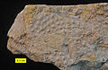 Phaenopora superba, a bryozoan from the Brassfield Formation.
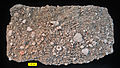 Encrinite from the Brassfield Formation (Silurian) near Fairborn, Ohio.


