
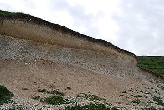
Erosion is the action of surface processes that removes soil, rock, or dissolved material from one location on the Earth's crust and then transports it to another location where it is deposited. Erosion is distinct from weathering which involves no movement. Removal of rock or soil as clastic sediment is referred to as physical or mechanical erosion; this contrasts with chemical erosion, where soil or rock material is removed from an area by dissolution. Eroded sediment or solutes may be transported just a few millimetres, or for thousands of kilometres.

Physical geography is one of the three main branches of geography. Physical geography is the branch of natural science which deals with the processes and patterns in the natural environment such as the atmosphere, hydrosphere, biosphere, and geosphere. This focus is in contrast with the branch of human geography, which focuses on the built environment, and technical geography, which focuses on using, studying, and creating tools to obtain, analyze, interpret, and understand spatial information. The three branches have significant overlap, however.
Pedology is a discipline within soil science which focuses on understanding and characterizing soil formation, evolution, and the theoretical frameworks for modeling soil bodies, often in the context of the natural environment. Pedology is often seen as one of two main branches of soil inquiry, the other being edaphology which is traditionally more agronomically oriented and focuses on how soil properties influence plant communities. In studying the fundamental phenomenology of soils, e.g. soil formation, pedologists pay particular attention to observing soil morphology and the geographic distributions of soils, and the placement of soil bodies into larger temporal and spatial contexts. In so doing, pedologists develop systems of soil classification, soil maps, and theories for characterizing temporal and spatial interrelations among soils. There are a few noteworthy sub-disciplines of pedology; namely pedometrics and soil geomorphology. Pedometrics focuses on the development of techniques for quantitative characterization of soils, especially for the purposes of mapping soil properties whereas soil geomorphology studies the interrelationships between geomorphic processes and soil formation.

Geomorphology is the scientific study of the origin and evolution of topographic and bathymetric features generated by physical, chemical or biological processes operating at or near Earth's surface. Geomorphologists seek to understand why landscapes look the way they do, to understand landform and terrain history and dynamics and to predict changes through a combination of field observations, physical experiments and numerical modeling. Geomorphologists work within disciplines such as physical geography, geology, geodesy, engineering geology, archaeology, climatology, and geotechnical engineering. This broad base of interests contributes to many research styles and interests within the field.

A mesa is an isolated, flat-topped elevation, ridge or hill, which is bounded from all sides by steep escarpments and stands distinctly above a surrounding plain. Mesas characteristically consist of flat-lying soft sedimentary rocks capped by a more resistant layer or layers of harder rock, e.g. shales overlain by sandstones. The resistant layer acts as a caprock that forms the flat summit of a mesa. The caprock can consist of either sedimentary rocks such as sandstone and limestone; dissected lava flows; or a deeply eroded duricrust. Unlike plateau, whose usage does not imply horizontal layers of bedrock, e.g. Tibetan Plateau, the term mesa applies exclusively to the landforms built of flat-lying strata. Instead, flat-topped plateaus are specifically known as tablelands.

In geology and geomorphology a base level is the lower limit for an erosion process. The modern term was introduced by John Wesley Powell in 1875. The term was subsequently appropriated by William Morris Davis who used it in his cycle of erosion theory. The "ultimate base level" is the surface that results from projection of the sea level under landmasses. It is to this base level that topography tends to approach due to erosion, eventually forming a peneplain close to the end of a cycle of erosion.

A cuesta is a hill or ridge with a gentle slope on one side, and a steep slope on the other. In geology, the term is more specifically applied to a ridge where a harder sedimentary rock overlies a softer layer, the whole being tilted somewhat from the horizontal. This results in a long and gentle backslope called a dip slope that conforms with the dip of resistant strata, called caprock. Where erosion has exposed the frontslope of this, a steep slope or escarpment occurs. The resulting terrain may be called scarpland.

In geology, a terrace is a step-like landform. A terrace consists of a flat or gently sloping geomorphic surface, called a tread, that is typically bounded on one side by a steeper ascending slope, which is called a "riser" or "scarp". The tread and the steeper descending slope together constitute the terrace. Terraces can also consist of a tread bounded on all sides by a descending riser or scarp. A narrow terrace is often called a bench.
In geomorphology, a knickpoint or nickpoint is part of a river or channel where there is a sharp change in channel bed slope, such as a waterfall or lake. Knickpoints reflect different conditions and processes on the river, often caused by previous erosion due to glaciation or variance in lithology. In the cycle of erosion model, knickpoints advance one cycle upstream, or inland, replacing an older cycle. A knickpoint that occurs at the head of a channel is called a headcut. Headcuts resulting in headward erosion are hallmarks of unstable expanding drainage features such as actively eroding gullies.

Sir Charles Andrew Cotton was a New Zealand geologist and geomorphologist, described as one of the leading scientists that New Zealand has produced.
Luna Bergere Leopold was a leading U.S. geomorphologist and hydrologist, and son of Aldo Leopold. He received a B.S. in civil engineering from the University of Wisconsin in 1936; an M.S. in physics-meteorology from the University of California, Los Angeles in 1944; and a Ph.D. in geology from Harvard University in 1950.
Physiographic regions are a means of defining Earth's landforms into independently distinct, mutually exclusive areas, independent of political boundaries. It is based upon the classic three-tiered approach by Nevin M. Fenneman in 1916, that separates landforms into physiographic divisions, physiographic provinces, and physiographic sections.
Sir Ronald Urwick Cooke, FRGS DL is a professor of geography and geomorphology who was vice-Chancellor of the University of York from 1993 to 2002.

The British Society for Geomorphology (BSG), incorporating the British Geomorphological Research Group (BGRG), is the professional organisation for British geomorphologists and provides a community and services for those involved in teaching or research in geomorphology, both in the UK and overseas. The society’s journal, Earth Surface Processes and Landforms is published by Wiley-Blackwell and online access is available free to members. The society is affiliated with the Royal Geographical Society as an affiliated research group and with the Geological Society of London as a specialist group.

Ausonia Mensa is a mensa in the Hellas quadrangle of Mars, located at 30.3° S and 262.3° W. It is 103 km (64 mi) across and was named after an albedo feature name. The term "mensa" is used for a flat-topped prominence with cliff-like edges. Ausonia Mensa has many small channels. Some features look like alluvial fans. These channels add to the mass of evidence that water once flowed on Mars. Images of curved channels have been seen in images from Mars spacecraft dating back to the early 1970s with the Mariner 9 orbiter.

A fjard is a large open space of water between groups of islands or mainland in archipelagos. Fjards can be found along sea coasts, in freshwater lakes or in rivers. Fjard and fjord were originally the same word, and they generally meant sailable waterway. In Scandinavia, fjords dominate along the North Sea coast while fjards dominate the Baltic Sea coast.
Robert Phillip Sharp was an American geomorphologist and expert on the geological surfaces of the Earth and the planet Mars. Sharp served as the chairman of the Division of Geological Sciences at California Institute of Technology (Caltech) from 1952 to 1968. He built the modern department and especially recruited new faculty in geochemistry, tectonic geomorphology, planetary science, and field geology.

Periglaciation describes geomorphic processes that result from seasonal thawing and freezing, very often in areas of permafrost. The meltwater may refreeze in ice wedges and other structures. "Periglacial" originally suggested an environment located on the margin of past glaciers. However, freeze and thaw cycles influence landscapes also outside areas of past glaciation. Therefore, periglacial environments are anywhere when freezing and thawing modify the landscape in a significant manner.

Hipparchus is an impact crater in the Phaethontis quadrangle of Mars, located at 44.8° S latitude and 151.4° W longitude. It is 93 kilometers in diameter. It was named after the ancient Greek astronomer Hipparchus in 1973.

Climatic geomorphology is the study of the role of climate in shaping landforms and the earth-surface processes. An approach used in climatic geomorphology is to study relict landforms to infer ancient climates. Being often concerned about past climates climatic geomorphology considered sometimes to be an aspect of historical geology. Since landscape features in one region might have evolved under climates different from those of the present, studying climatically disparate regions might help understand present-day landscapes. For example, Julius Büdel studied both cold-climate processes in Svalbard and weathering processes in tropical India to understand the origin of the relief of Central Europe, which he argued was a palimpsest of landforms formed at different times and under different climates.