Urban flooding

Last updated
Flooding in Bom Principio of the Cai River in Brazil during July 2020 Enchente do rio Cai em Bom Principio em julho de 2020.jpg
Flooding in Bom Princípio of the Caí River in Brazil during July 2020

Urban flooding is the inundation of land or property in a built environment, particularly in more densely populated areas, caused by rainfall overwhelming the capacity of drainage systems, such as storm sewers. Urban flooding is a condition that is characterized by its repetitive and systemic impacts on communities, that can happen regardless of whether or not affected communities are located within designated floodplains or near any body of water. [1] It is triggered for example by an overflow of rivers and lakes, flash flooding or snowmelt. During the flood, stormwater or water released from damaged water mains may accumulate on property and in public rights-of-way, seep through building walls and floors, or backup into buildings through sewer pipes, toilets and sinks.

Contents

In urban areas, flood effects can be exacerbated by existing paved streets and roads, which increase the speed of flowing water. Impervious surfaces prevent rainfall from infiltrating into the ground, thereby causing a higher surface run-off that may be in excess of local drainage capacity. [2]

The effects of climate change also have an impact on the frequency of urban flooding: The IPCC Sixth Assessment Report pointed out that "Sea level increase and increases in tropical cyclone storm surge and rainfall intensity will increase the probability of coastal city flooding". [3] :925

Urban flooding is a hazard to both the population and infrastructure. Some well known disaster events include the inundations of Nîmes (France) in 1998 and Vaison-la-Romaine (France) in 1992, the flooding of New Orleans (United States) in 2005, and the flooding in Rockhampton, Bundaberg, Brisbane during the 2010–2011 summer in Queensland (Australia).

Causes

People kayaking down a street in Mid-City New Orleans following flooding in 2019 Banks Street Kayakers - Mid-City New Orleans flooding July 2019.jpg
People kayaking down a street in Mid-City New Orleans following flooding in 2019

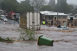
There are several types of urban flooding, each with a different cause:

Different types of urban flooding create different impacts and require different mitigation strategies.[ citation needed ]

Any activities that enlarge the impermeable surface areas in a city can increase the flood risk. Impermeable surface areas are generated through soil sealing as this reduces drainage options of floodwaters. [3] :925 As the pace of urbanization accelerates around the world, urban flooding has the potential to affect more people. [3] :925

Many of the common causes of urban flooding, including storm surges, heavy precipitation, and river overflow, are expected to increase in frequency and severity as climate change intensifies and causes increases in ocean and river levels. [4] In particular, erratic rainfall patterns are expected to increase the frequency and severity of both pluvial flooding (as excessive amounts of rainfall in urban areas and cannot be adequately absorbed by existing drainage systems and pervious areas) and fluvial flooding (as excessive rainfall over a river can cause flooding and overflow, either where it occurs or downstream along the path of the river). The frequency and severity of extreme storm events, including hurricanes and other types of tropical cyclones, are also expected to increase. [5] Additionally, due to the geographic distribution of developing urban areas, the land area potentially exposed to climate change-related flooding is expected to increase significantly. [6]

The IPCC Sixth Assessment Report pointed out that "Sea level increase and increases in tropical cyclone storm surge and rainfall intensity will increase the probability of coastal city flooding". [3] :925

Due to an increase in heavy rainfall events, floods are likely to become more severe when they do occur. [7] :1155 The interactions between rainfall and flooding are complex. There are some regions in which flooding is expected to become rarer. This depends on several factors. These include changes in rain and snowmelt, but also soil moisture. [7] :1156 Climate change leaves soils drier in some areas, so they may absorb rainfall more quickly. This leads to less flooding. Dry soils can also become harder. In this case heavy rainfall runs off into rivers and lakes. This increases risks of flooding. [7] :1155

Impacts

Trapped woman on a car roof during flash flooding in Toowoomba, Queensland, Australia Trapped woman on a car roof during flash flooding in Toowoomba 2.jpg
Trapped woman on a car roof during flash flooding in Toowoomba, Queensland, Australia

Some of the most obvious impacts of urban flooding are those to human life and to property damage. In 2020, floods caused an estimated 6,000 deaths and caused US$51.3B in damages globally. [8] Residents at low-elevated regions are often at risk of inundation, financial loss, and even the loss of lives.

Urban flooding also impacts critical public services, including public transportation systems. [9] [10] Traffic congestion can be worsened by urban flood events. [11]

Economic impacts

Houses in Corinda flooded during 2022 eastern Australia floods Houses in Corinda flooded during 2022 Brisbane flood, 05.jpg
Houses in Corinda flooded during 2022 eastern Australia floods

The IPCC summarized the current research regarding economic impacts as follows (as of 2022): "economic risks associated with future surface water flooding in towns and cities are considerable." [3] :925 This is explained as part of the dynamic Interaction of urban systems with climate. [3] :922

Urban flooding has significant economic implications. In the US, industry experts estimate that wet basements can lower property values by 10%-25% and are cited among the top reasons for not purchasing a home. [12] According to the U.S Federal Emergency Management Agency (FEMA), almost 40% of small businesses never reopen their doors following a flooding disaster. [13] In the UK, urban flooding is estimated to cost £270 million a year in England and Wales; 80,000 homes are at risk. [14]

A study of Cook County, Illinois, identified 177,000 property damage insurance claims made across 96% of the county's ZIP codes over a five-year period from 2007 to 2011. This is the equivalent of one in six properties in the County making a claim. Average payouts per claim were $3,733 across all types of claims, with total claims amounting to $660 million over the five years examined. [12]

Urban flooding can also create far-reaching supply chain issues, [15] [16] which can create significant interruptions in the availability of goods and services, as well as financial losses for businesses.

Between 1961 and 2020, nearly 10,000 cases were reported with 1.3 million deaths and a minimum of US$3.3 trillion of financial losses at an equivalent loss rate of almost US$1800 per second. On average, the total reported deaths worldwide were around 23,000/year for the past 6 decades at an equivalent rate of one death every 24 min. [17]

Modeling

Localized models

Flood modeling is often conducted in a very localized fashion, with hydrological models created for individual municipalities and incorporating details about buildings, infrastructure, vegetation, land use, and drainage systems. [18] This localized modeling can be very useful, especially when paired with historical data, in predicting which specific locations (e.g. streets or intersections) will be the most impacted during a flood event and can be helpful in designing effective mitigation systems specific to local needs.

Flood flows in urban environments have been investigated relatively recently despite many centuries of flood events. [19] Some researchers mentioned the storage effect in urban areas. Several studies looked into the flow patterns and redistribution in streets during storm events and the implication in terms of flood modelling. [20] Some recent research considered the criteria for safe evacuation of individuals in flooded areas. [21] But some recent field measurements during the 2010–2011 Queensland floods showed that any criterion solely based upon the flow velocity, water depth or specific momentum cannot account for the hazards caused by the velocity and water depth fluctuations. [19] These considerations ignore further the risks associated with large debris entrained by the flow motion. [21]

The curve number (CN) rainfall–runoff model is widely adopted. However, it had been reported to repeatedly fail in consistently predicting runoff results worldwide. Unlike the existing antecedent moisture condition concept, one of the recent studies preserved the parsimonious curve number runoff predictive basic framework for model calibration according to different watershed's saturation conditions under guidance from inferential statistics. The study also showed that the existing CN runoff predictive model was not statistically significant without recalibration. CN runoff predictive model can be calibrated according to regional rainfall-runoff dataset for urban flash flood prediction. [17]

Modeling of climate change impacts

Modeling of climate change impacts, on the other hand, is often done from a "top-down", global perspective. While these models can be helpful in predicting worldwide effects of global warming and in raising awareness about large-scale impacts, their spatial resolution is often limited to 25 km or more, making them less helpful for local planners in mitigating the effects of climate change on a street-by-street scale. [22]

Some advocate for an integration of localized hydrological modeling with larger-scale climate modeling, claiming that such integration allows the benefits of both forms of modeling to be realized simultaneously and creates the potential for modeling flooding due to climate change in a way that allows planners to design specific strategies to mitigate it at the local level. [23]

Scientists investigate climate change scenarios and their impacts on urban flooding and found that: "For example in the UK, expected annual damages from surface water may increase by £60–200 million for projected 2–4°C warming scenarios; enhanced adaptation actions could manage flooding up to a 2°C scenario but will be insufficient beyond that. [3] :926

Mitigation and management

Flood flows in urban environments have been studied relatively recently despite many centuries of flood events. [24] Some recent research has considered the criteria for safe evacuation of individuals in flooded areas. [25]

Integrated urban water management

Comparing the natural and urban water cycle and streetscapes in conventional and Blue-Green Cities Comparing the natural and urban water cycle and streetscapes in conventional and Blue-Green Cities.png
Comparing the natural and urban water cycle and streetscapes in conventional and Blue-Green Cities
Integrated urban water management (IUWM) is the practice of managing freshwater, wastewater, and storm water as components of a basin-wide management plan. It builds on existing water supply and sanitation considerations within an urban settlement by incorporating urban water management within the scope of the entire river basin. [26] IUWM is commonly seen as a strategy for achieving the goals of Water Sensitive Urban Design. IUWM seeks to change the impact of urban development on the natural water cycle, based on the premise that by managing the urban water cycle as a whole; a more efficient use of resources can be achieved providing not only economic benefits but also improved social and environmental outcomes. One approach is to establish an inner, urban, water cycle loop through the implementation of reuse strategies. Developing this urban water cycle loop requires an understanding both of the natural, pre-development, water balance and the post-development water balance. Accounting for flows in the pre- and post-development systems is an important step toward limiting urban impacts on the natural water cycle. [27]

Gray infrastructure

One traditional urban flooding management strategy is gray infrastructure, which is a set of infrastructure types (including dams and seawalls) traditionally constructed of concrete or other impervious materials and designed to prevent the flow of water. While gray infrastructure can be effective in preventing flooding-related damage [28] and can be economically valuable, [29] some models suggest that gray infrastructure may become less effective at preventing flood-related impacts in urban areas in the future as climate change causes flooding intensity and frequency to increase. [30]

Green infrastructure

A schematic showing how green infrastructure and water management can be integrated Planning approach of blue-green infrastructure.jpg
A schematic showing how green infrastructure and water management can be integrated

An alternative to gray infrastructure is green infrastructure, which refers to a set of strategies for absorbing and storing stormwater at or close to the location where it falls. Green infrastructure includes many types of vegetation, large open areas with pervious surfaces, and even rainwater collection devices. [31] Green infrastructure may prove to be an effective and cost-efficient way to reduce the extent of urban flooding. [32]

Drainage systems

One way urban flooding is commonly mitigated is via urban drainage systems, which transport storm water away from streets and businesses and into appropriate storage and drainage areas. While urban drainage systems help municipalities manage flooding and can be scaled up as population and urban extent increase, these systems may not be sufficient to mitigate additional future flooding due to climate change. [33]

Retention ponds such as this one in Dunfermline, Scotland, are considered components of a sustainable drainage system. Suds pond at Cromar Drive - geograph.org.uk - 1756832.jpg
Retention ponds such as this one in Dunfermline, Scotland, are considered components of a sustainable drainage system.

Sustainable drainage systems (also known as SuDS, [34] SUDS, [35] [36] or sustainable urban drainage systems [37] ) are a collection of water management practices that aim to align modern drainage systems with natural water processes and are part of a larger green infrastructure strategy. [38] SuDS efforts make urban drainage systems more compatible with components of the natural water cycle such as storm surge overflows, soil percolation, and bio-filtration. These efforts hope to mitigate the effect human development has had or may have on the natural water cycle, particularly surface runoff and water pollution trends. [39]

SuDS have become popular in recent decades as understanding of how urban development affects natural environments, as well as concern for climate change and sustainability, have increased. SuDS often use built components that mimic natural features in order to integrate urban drainage systems into the natural drainage systems or a site as efficiently and quickly as possible. SUDS infrastructure has become a large part of the Blue-Green Cities demonstration project in Newcastle upon Tyne. [40]

Land use

Since the ratio of pervious to impervious surfaces across an area is important in flooding management, understanding and altering land use and the proportion of land allocated to different purposes/use types is important in flood management planning. [41] [42] In particular, increasing the percent of land dedicated to open, vegetated space can be helpful in providing an absorption and storage area for storm runoff. [43] These areas can often be integrated with existing urban amenities, such as parks and golf courses. Increasing the pervious surface fraction of an urban area (e.g. by planting green walls/roofs or using alternative pervious construction materials) can also help de-risk climate-linked flood events. [44] [45]

Examples

United States

One of the most well known at-risk urban areas in the United States is New Orleans. Because of its coastal location and low elevation, the city is prone to flooding due to tropical storms, including cyclones and hurricanes and is particularly vulnerable to changes in sea level or storm frequency. In 2005, Hurricane Katrina caused more than 1800 deaths and US$170B in damages. [46] After Katrina, additional flood protections were built with a changing climate in mind; these protections have proved effective in reducing damages due to subsequent extreme weather events, such as Hurricane Ida. [47]

During the summer of 2021, Hurricanes Henri and Ida caused significant flooding in many cities along the east coast of the United States. [48] [49] In particular, New York City experienced record levels of rainfall, prompting many to question whether the city should implement additional flood protection measures in anticipation of potential future flood events. [50] In September 2021, the New York City mayoral office released a new rainfall preparedness plan. [51]

See also

Examples by country or region:

Related Research Articles

<span class="mw-page-title-main">Flood</span> Water overflow submerging usually-dry land

A flood is an overflow of water that submerges land that is usually dry. In the sense of "flowing water", the word may also be applied to the inflow of the tide. Floods are an area of study of the discipline hydrology and are of significant concern in agriculture, civil engineering and public health. Human changes to the environment often increase the intensity and frequency of flooding, for example land use changes such as deforestation and removal of wetlands, changes in waterway course or flood controls such as with levees, and larger environmental issues such as climate change and sea level rise. In particular climate change's increased rainfall and extreme weather events increases the severity of other causes for flooding, resulting in more intense floods and increased flood risk.

Energy-efficient landscaping is a type of landscaping designed for the purpose of conserving energy. There is a distinction between the embedded energy of materials and constructing the landscape, and the energy consumed by the maintenance and operations of a landscape.

<span class="mw-page-title-main">Stormwater</span> Water that originates during precipitation events and snow/ice melt

Stormwater, also written storm water, is water that originates from precipitation (storm), including heavy rain and meltwater from hail and snow. Stormwater can soak into the soil (infiltrate) and become groundwater, be stored on depressed land surface in ponds and puddles, evaporate back into the atmosphere, or contribute to surface runoff. Most runoff is conveyed directly as surface water to nearby streams, rivers or other large water bodies without treatment.

<span class="mw-page-title-main">Permeable paving</span> Roads built with water-pervious materials

Permeable paving surfaces are made of either a porous material that enables stormwater to flow through it or nonporous blocks spaced so that water can flow between the gaps. Permeable paving can also include a variety of surfacing techniques for roads, parking lots, and pedestrian walkways. Permeable pavement surfaces may be composed of; pervious concrete, porous asphalt, paving stones, or interlocking pavers. Unlike traditional impervious paving materials such as concrete and asphalt, permeable paving systems allow stormwater to percolate and infiltrate through the pavement and into the aggregate layers and/or soil below. In addition to reducing surface runoff, permeable paving systems can trap suspended solids, thereby filtering pollutants from stormwater.

<span class="mw-page-title-main">Combined sewer</span> Sewage collection system of pipes and tunnels designed to also collect surface runoff

A combined sewer is a type of gravity sewer with a system of pipes, tunnels, pump stations etc. to transport sewage and urban runoff together to a sewage treatment plant or disposal site. This means that during rain events, the sewage gets diluted, resulting in higher flowrates at the treatment site. Uncontaminated stormwater simply dilutes sewage, but runoff may dissolve or suspend virtually anything it contacts on roofs, streets, and storage yards. As rainfall travels over roofs and the ground, it may pick up various contaminants including soil particles and other sediment, heavy metals, organic compounds, animal waste, and oil and grease. Combined sewers may also receive dry weather drainage from landscape irrigation, construction dewatering, and washing buildings and sidewalks.

The United States Environmental Protection Agency (EPA) Storm Water Management Model (SWMM) is a dynamic rainfall–runoff–subsurface runoff simulation model used for single-event to long-term (continuous) simulation of the surface/subsurface hydrology quantity and quality from primarily urban/suburban areas.

<span class="mw-page-title-main">Rain garden</span> Runoff reducing landscaping method

Rain gardens, also called bioretention facilities, are one of a variety of practices designed to increase rain runoff reabsorption by the soil. They can also be used to treat polluted stormwater runoff. Rain gardens are designed landscape sites that reduce the flow rate, total quantity, and pollutant load of runoff from impervious urban areas like roofs, driveways, walkways, parking lots, and compacted lawn areas. Rain gardens rely on plants and natural or engineered soil medium to retain stormwater and increase the lag time of infiltration, while remediating and filtering pollutants carried by urban runoff. Rain gardens provide a method to reuse and optimize any rain that falls, reducing or avoiding the need for additional irrigation. A benefit of planting rain gardens is the consequential decrease in ambient air and water temperature, a mitigation that is especially effective in urban areas containing an abundance of impervious surfaces that absorb heat in a phenomenon known as the heat-island effect.

<span class="mw-page-title-main">Surface runoff</span> Flow of excess rainwater not infiltrating in the ground over its surface

Surface runoff is the unconfined flow of water over the ground surface, in contrast to channel runoff. It occurs when excess rainwater, stormwater, meltwater, or other sources, can no longer sufficiently rapidly infiltrate in the soil. This can occur when the soil is saturated by water to its full capacity, and the rain arrives more quickly than the soil can absorb it. Surface runoff often occurs because impervious areas do not allow water to soak into the ground. Furthermore, runoff can occur either through natural or human-made processes.

<span class="mw-page-title-main">Sustainable drainage system</span>

Sustainable drainage systems are a collection of water management practices that aim to align modern drainage systems with natural water processes and are part of a larger green infrastructure strategy. SuDS efforts make urban drainage systems more compatible with components of the natural water cycle such as storm surge overflows, soil percolation, and bio-filtration. These efforts hope to mitigate the effect human development has had or may have on the natural water cycle, particularly surface runoff and water pollution trends.

<span class="mw-page-title-main">Pervious concrete</span> High-porosity, water-permeable concrete

Pervious concrete is a special type of concrete with a high porosity used for concrete flatwork applications that allows water from precipitation and other sources to pass directly through, thereby reducing the runoff from a site and allowing groundwater recharge.

<span class="mw-page-title-main">Green infrastructure</span> Sustainable and resilient infrastructure

Green infrastructure or blue-green infrastructure refers to a network that provides the “ingredients” for solving urban and climatic challenges by building with nature. The main components of this approach include stormwater management, climate adaptation, the reduction of heat stress, increasing biodiversity, food production, better air quality, sustainable energy production, clean water, and healthy soils, as well as more anthropocentric functions, such as increased quality of life through recreation and the provision of shade and shelter in and around towns and cities. Green infrastructure also serves to provide an ecological framework for social, economic, and environmental health of the surroundings. More recently scholars and activists have also called for green infrastructure that promotes social inclusion and equality rather than reinforcing pre-existing structures of unequal access to nature-based services.

<span class="mw-page-title-main">Urban runoff</span> Surface runoff of water caused by urbanization

Urban runoff is surface runoff of rainwater, landscape irrigation, and car washing created by urbanization. Impervious surfaces are constructed during land development. During rain, storms, and other precipitation events, these surfaces, along with rooftops, carry polluted stormwater to storm drains, instead of allowing the water to percolate through soil. This causes lowering of the water table and flooding since the amount of water that remains on the surface is greater. Most municipal storm sewer systems discharge untreated stormwater to streams, rivers, and bays. This excess water can also make its way into people's properties through basement backups and seepage through building wall and floors.

<span class="mw-page-title-main">Flood control</span> Methods used to reduce or prevent the detrimental effects of flood waters

Flood control methods are used to reduce or prevent the detrimental effects of flood waters. Flood relief methods are used to reduce the effects of flood waters or high water levels. Flooding can be caused by a mix of both natural processes, such as extreme weather upstream, and human changes to waterbodies and runoff. A distinction is made between structural and non-structural flood control measures. Structural methods physically restrain the flood waters, whereas non-structural methods do not. Building hard infrastructure to prevent flooding, such as flood walls, is effective at managing flooding. However, increased best practice within landscape engineering is to rely more on soft infrastructure and natural systems, such as marshes and flood plains, for handling the increase in water. To prevent or manage coastal flooding, coastal management practices have to handle natural processes like tides but also the human-caused sea level rise.

<span class="mw-page-title-main">Water security</span> A goal of water management to harness water-related opportunities and manage risks

The aim of water security is to make the most of water's benefits for humans and ecosystems. The second aim is to limit the risks of destructive impacts of water to an acceptable level. These risks include for example too much water (flood), too little water or poor quality (polluted) water. People who live with a high level of water security always have access to "an acceptable quantity and quality of water for health, livelihoods and production". For example, access to water, sanitation and hygiene services is one part of water security. Some organizations use the term water security more narrowly for water supply aspects only.

<span class="mw-page-title-main">Coastal flooding</span> Type of natural disaster

Coastal flooding occurs when dry and low-lying land is submerged (flooded) by seawater. The range of a coastal flooding is a result of the elevation of floodwater that penetrates the inland which is controlled by the topography of the coastal land exposed to flooding. The seawater can flood the land via several different paths: direct flooding, overtopping of a barrier, or breaching of a barrier. Coastal flooding is largely a natural event. Due to the effects of climate change and an increase in the population living in coastal areas, the damage caused by coastal flood events has intensified and more people are being affected.

<span class="mw-page-title-main">Low-impact development (U.S. and Canada)</span>

Low-impact development (LID) is a term used in Canada and the United States to describe a land planning and engineering design approach to manage stormwater runoff as part of green infrastructure. LID emphasizes conservation and use of on-site natural features to protect water quality. This approach implements engineered small-scale hydrologic controls to replicate the pre-development hydrologic regime of watersheds through infiltrating, filtering, storing, evaporating, and detaining runoff close to its source. Green infrastructure investments are one approach that often yields multiple benefits and builds city resilience.

<span class="mw-page-title-main">Colin Thorne</span> English academic

Colin Reginald Thorne is Chair of Physical Geography at the University of Nottingham. A fluvial geomorphologist with an educational background in environmental sciences, civil engineering and physical geography; he has published 9 books and over 120 journal papers and book chapters.

<span class="mw-page-title-main">Climate change in the Philippines</span> Impact of climate change on the Philippines

Climate change is having serious impacts in the Philippines such as increased frequency and severity of natural disasters, sea level rise, extreme rainfall, resource shortages, and environmental degradation. All of these impacts together have greatly affected the Philippines' agriculture, water, infrastructure, human health, and coastal ecosystems and they are projected to continue having devastating damages to the economy and society of the Philippines.

<span class="mw-page-title-main">Climate change in Indonesia</span> Emissions, impacts and responses of Indonesia

Due to its geographical and natural diversity, Indonesia is one of the countries most susceptible to the impacts of climate change. This is supported by the fact that Jakarta has been listed as the world's most vulnerable city, regarding climate change. It is also a major contributor as of the countries that has contributed most to greenhouse gas emissions due to its high rate of deforestation and reliance on coal power.

Rainwater management is a series of countermeasures to reduce runoff volume and improve water quality by replicating the natural hydrology and water balance of a site, with consideration of rainwater harvesting, urban flood management and rainwater runoff pollution control.

References

  1. "The Prevalence and Cost of Urban Flooding". Chicago, Illinois: Center for Neighborhood Technology. May 2013.
  2. Urban adaptation to climate change in Europe (Report). European Environment Agency. 2012. ISSN   1725-9177.
  3. 1 2 3 4 5 6 7 Dodman, D., B. Hayward, M. Pelling, V. Castan Broto, W. Chow, E. Chu, R. Dawson, L. Khirfan, T. McPhearson, A. Prakash, Y. Zheng, and G. Ziervogel, 2022: Chapter 6: Cities, Settlements and Key Infrastructure. In: Climate Change 2022: Impacts, Adaptation and Vulnerability. Contribution of Working Group II to the Sixth Assessment Report of the Intergovernmental Panel on Climate Change [H.-O. Pörtner, D.C. Roberts, M. Tignor, E.S. Poloczanska, K. Mintenbeck, A. Alegría, M. Craig, S. Langsdorf, S. Löschke, V. Möller, A. Okem, B. Rama (eds.)]. Cambridge University Press, Cambridge, UK and New York, NY, USA, pp. 907–1040, doi:10.1017/9781009325844.008.
  4. Symonds, Michael (2021-08-10). "Faculty Opinions recommendation of IPCC, 2021: Summary for Policymakers. In: Climate Change 2021: The Physical Science Basis. Contribution of Working Group I to the Sixth Assessment Report of the Intergovernmental Panel on Climate Change". doi: 10.3410/f.740620545.793587812 . S2CID   242570539.{{cite journal}}: Cite journal requires |journal= (help)
  5. Knutson, Thomas R.; McBride, John L.; Chan, Johnny; Emanuel, Kerry; Holland, Greg; Landsea, Chris; Held, Isaac; Kossin, James P.; Srivastava, A. K.; Sugi, Masato (2010-02-21). "Tropical cyclones and climate change". Nature Geoscience. 3 (3): 157–163. Bibcode:2010NatGe...3..157K. doi:10.1038/ngeo779. hdl: 1721.1/62558 . ISSN   1752-0894.
  6. Anderson, Tiffany R.; Fletcher, Charles H.; Barbee, Matthew M.; Romine, Bradley M.; Lemmo, Sam; Delevaux, Jade M.S. (2018-09-27). "Modeling multiple sea level rise stresses reveals up to twice the land at risk compared to strictly passive flooding methods". Scientific Reports. 8 (1): 14484. Bibcode:2018NatSR...814484A. doi:10.1038/s41598-018-32658-x. ISSN   2045-2322. PMC   6160426 . PMID   30262891.
  7. 1 2 3 Douville, H., K. Raghavan, J. Renwick, R.P. Allan, P.A. Arias, M. Barlow, R. Cerezo-Mota, A. Cherchi, T.Y. Gan, J. Gergis, D. Jiang, A. Khan, W. Pokam Mba, D. Rosenfeld, J. Tierney, and O. Zolina, 2021: Chapter 8: Water Cycle Changes. In Climate Change 2021: The Physical Science Basis. Contribution of Working Group I to the Sixth Assessment Report of the Intergovernmental Panel on Climate Change [Masson-Delmotte, V., P. Zhai, A. Pirani, S.L. Connors, C. Péan, S. Berger, N. Caud, Y. Chen, L. Goldfarb, M.I. Gomis, M. Huang, K. Leitzell, E. Lonnoy, J.B.R. Matthews, T.K. Maycock, T. Waterfield, O. Yelekçi, R. Yu, and B. Zhou (eds.)]. Cambridge University Press, Cambridge, United Kingdom and New York, NY, US, pp. 1055–1210, doi:10.1017/9781009157896.010.
  8. Disasters, Centre for Research on the Epidemiology of; Reduction, UN Office for Disaster Risk (2021). "2020 The Non-Covid year in disasters: Global trends and perspectives".{{cite journal}}: Cite journal requires |journal= (help)
  9. Suarez, Pablo; Anderson, William; Mahal, Vijay; Lakshmanan, T.R. (May 2005). "Impacts of flooding and climate change on urban transportation: A systemwide performance assessment of the Boston Metro Area". Transportation Research Part D: Transport and Environment. 10 (3): 231–244. doi:10.1016/j.trd.2005.04.007. ISSN   1361-9209.
  10. Chang, Heejun; Lafrenz, Martin; Jung, Il-Won; Figliozzi, Miguel; Platman, Deena; Pederson, Cindy (2010-08-31). "Potential Impacts of Climate Change on Flood-Induced Travel Disruptions: A Case Study of Portland, Oregon, USA". Annals of the Association of American Geographers. 100 (4): 938–952. doi:10.1080/00045608.2010.497110. ISSN   0004-5608. S2CID   16751304.
  11. Zhu, Jingxuan; Dai, Qiang; Deng, Yinghui; Zhang, Aorui; Zhang, Yingzhe; Zhang, Shuliang (2018-05-10). "Indirect Damage of Urban Flooding: Investigation of Flood-Induced Traffic Congestion Using Dynamic Modeling". Water. 10 (5): 622. doi: 10.3390/w10050622 . hdl: 1983/a361dcd5-80d9-4033-a831-59f916bbe1a2 . ISSN   2073-4441.
  12. 1 2 "The Prevalence and Cost of Urban Flooding" (PDF). Chicago, Illinois: Center for Neighborhood Technology. May 2013..
  13. "Protecting Your Businesses". Federal Emergency Management Agency (U.S.). March 2013. Archived from the original on 2013-09-17.
  14. Parliamentary Office of Science and Technology, London, UK. "Urban Flooding." Postnote 289, July 2007
  15. Ohmori, Shunichi; Yoshimoto, Kazuho (2013-06-30). "A Framework of Managing Supply Chain Disruption Risks Using Network Reliability". Industrial Engineering and Management Systems. 12 (2): 103–111. doi: 10.7232/iems.2013.12.2.103 . ISSN   1598-7248. S2CID   167979543.
  16. Jongman, Brenden (2018-05-29). "Effective adaptation to rising flood risk". Nature Communications. 9 (1): 1986. Bibcode:2018NatCo...9.1986J. doi:10.1038/s41467-018-04396-1. ISSN   2041-1723. PMC   5974412 . PMID   29844334.
  17. 1 2 Ling, Lloyd; Lai, Sai Hin; Yusop, Zulkifli; Chin, Ren Jie; Ling, Joan Lucille (Jan 2022). "Formulation of Parsimonious Urban Flash Flood Predictive Model with Inferential Statistics". Mathematics. 10 (2): 175. doi: 10.3390/math10020175 .
  18. Rosenzweig, B. R.; Cantis, P. Herreros; Kim, Y.; Cohn, A.; Grove, K.; Brock, J.; Yesuf, J.; Mistry, P.; Welty, C.; McPhearson, T.; Sauer, J. (2021). "The Value of Urban Flood Modeling". Earth's Future. 9 (1): e2020EF001739. Bibcode:2021EaFut...901739R. doi: 10.1029/2020EF001739 . hdl: 11603/20943 . ISSN   2328-4277. S2CID   234311646.
  19. 1 2 Brown, Richard; Chanson, Hubert; McIntosh, Dave; Madhani, Jay (2011). Turbulent Velocity and Suspended Sediment Concentration Measurements in an Urban Environment of the Brisbane River Flood Plain at Gardens Point on 12–13 January 2011. Hydraulic Model Report No. CH83/11. Brisbane, Australia: The University of Queensland, School of Civil Engineering. ISBN   978-1-74272-027-2.[ page needed ]
  20. Werner, M.G.F.; Hunter, N.M.; Bates, P.D. (November 2005). "Identifiability of distributed floodplain roughness values in flood extent estimation". Journal of Hydrology. 314 (1–4): 139–157. Bibcode:2005JHyd..314..139W. doi:10.1016/j.jhydrol.2005.03.012.
  21. 1 2 Chanson, Hubert; Brown, R.; McIntosh, D. (2014). "Human body stability in floodwaters: The 2011 flood in Brisbane CBD" (PDF). Hydraulic structures and society - Engineering challenges and extremes. pp. 1–9. doi:10.14264/uql.2014.48. ISBN   978-1-74272-115-6.
  22. Setzer, Maria. "Climate Modeling". www.gfdl.noaa.gov. Retrieved 2021-11-07.
  23. Cheng, Chingwen; Yang, Y.C. Ethan; Ryan, Robert; Yu, Qian; Brabec, Elizabeth (November 2017). "Assessing climate change-induced flooding mitigation for adaptation in Boston's Charles River watershed, USA". Landscape and Urban Planning. 167: 25–36. doi: 10.1016/j.landurbplan.2017.05.019 . ISSN   0169-2046.
  24. Brown, Richard; Chanson, Hubert; McIntosh, Dave; Madhani, Jay (2011). Turbulent Velocity and Suspended Sediment Concentration Measurements in an Urban Environment of the Brisbane River Flood Plain at Gardens Point on 12–13 January 2011. p. 120. ISBN   978-1-74272-027-2.{{cite book}}: |journal= ignored (help)
  25. Chanson, H.; Brown, R.; McIntosh, D. (26 June 2014). "Human body stability in floodwaters: The 2011 flood in Brisbane CBD". In Toombes, L. (ed.). Hydraulic structures and society - Engineering challenges and extremes (PDF). Brisbane, Australia: Proceedings of the 5th IAHR International Symposium on Hydraulic Structures (ISHS2014). pp. 1–9. doi:10.14264/uql.2014.48. ISBN   978-1-74272-115-6.
  26. Integrated urban water management : humid tropics. Jonathan Parkinson, J. A. Goldenfum, Carlos E. M. Tucci, International Hydrological Programme, Unesco. Boca Raton: CRC Press. 2010. p. 2. ISBN   978-0-203-88117-0. OCLC   671648461.{{cite book}}: CS1 maint: others (link)
  27. Barton, A.B. (2009). "Advancing IUWM through an understanding of the urban water balance". Australia's Commonwealth Scientific and Industrial Research Organisation (CSIRO). Retrieved 2009-09-14.
  28. "Water security: Gray or green?". Science. 349 (6248): 584. 2015-08-07. doi:10.1126/science.349.6248.584-a. ISSN   0036-8075. PMID   26250669.
  29. Davlasheridze, Meri; Fan, Qin (2019-08-07). "Valuing Seawall Protection in the Wake of Hurricane Ike". Economics of Disasters and Climate Change. 3 (3): 257–279. doi:10.1007/s41885-019-00045-z. ISSN   2511-1280. S2CID   201297569.
  30. Kim, Yeowon; Eisenberg, Daniel A.; Bondank, Emily N.; Chester, Mikhail V.; Mascaro, Giuseppe; Underwood, B. Shane (2017-10-26). "Fail-safe and safe-to-fail adaptation: decision-making for urban flooding under climate change". Climatic Change. 145 (3–4): 397–412. Bibcode:2017ClCh..145..397K. doi:10.1007/s10584-017-2090-1. ISSN   0165-0009. S2CID   158494951.
  31. US EPA, OW (2015-09-30). "What is Green Infrastructure?". www.epa.gov. Retrieved 2021-11-07.
  32. Chen, Jingqiu; Liu, Yaoze; Gitau, Margaret W.; Engel, Bernard A.; Flanagan, Dennis C.; Harbor, Jonathan M. (2019-05-15). "Evaluation of the effectiveness of green infrastructure on hydrology and water quality in a combined sewer overflow community". Science of the Total Environment. 665: 69–79. Bibcode:2019ScTEn.665...69C. doi: 10.1016/j.scitotenv.2019.01.416 . ISSN   0048-9697. PMID   30772580. S2CID   73457016.
  33. Skougaard Kaspersen, Per; Høegh Ravn, Nanna; Arnbjerg-Nielsen, Karsten; Madsen, Henrik; Drews, Martin (2017-08-18). "Comparison of the impacts of urban development and climate change on exposing European cities to pluvial flooding". Hydrology and Earth System Sciences. 21 (8): 4131–4147. Bibcode:2017HESS...21.4131S. doi: 10.5194/hess-21-4131-2017 . ISSN   1607-7938. S2CID   54025209.
  34. Sustainable Drainage System (SuDs) for Stormwater Management: A Technological and Policy Intervention to Combat Diffuse Pollution, Sharma, D., 2008
  35. "CIRIA guide to SUDS". Ciria.org. Retrieved 2014-01-21.
  36. "Planning and Sustainable Urban Drainage Systems. Planning Advice Note 61". Scottish Government Planning Services. 27 July 2001. Archived from the original on 18 February 2015.
  37. "Sustainable Urban Drainage Systems". www.sustainable-urban-drainage-systems.co.uk. Retrieved 2020-11-15.
  38. CIRIA SuDS Manual (Document reference : CIRIA C753), 2015
  39. Hoang, L (2016). "System interactions of stormwater management using sustainable urban drainage systems and green infrastructure". Urban Water Journal. 13 (7): 739–758. doi: 10.1080/1573062X.2015.1036083 .
  40. O'Donnell, E. C.; Lamond, J. E.; Thorne, C. R. (2017). "Recognising barriers to implementation of Blue-Green Infrastructure: a Newcastle case study". Urban Water Journal. 14 (9): 964–971. doi: 10.1080/1573062X.2017.1279190 . ISSN   1573-062X.
  41. Neupane, Barsha; Vu, Tue M.; Mishra, Ashok K. (2021-09-07). "Evaluation of land-use, climate change, and low-impact development practices on urban flooding". Hydrological Sciences Journal. 66 (12): 1729–1742. doi: 10.1080/02626667.2021.1954650 . ISSN   0262-6667. S2CID   238241352.
  42. Dammalage, T. L.; Jayasinghe, N. T. (2019-04-10). "Land-Use Change and Its Impact on Urban Flooding: A Case Study on Colombo District Flood on May 2016". Engineering, Technology & Applied Science Research. 9 (2): 3887–3891. doi: 10.48084/etasr.2578 . ISSN   1792-8036. S2CID   155967894.
  43. Kim, Hyomin; Lee, Dong-Kun; Sung, Sunyong (2016-01-30). "Effect of Urban Green Spaces and Flooded Area Type on Flooding Probability". Sustainability. 8 (2): 134. doi: 10.3390/su8020134 . ISSN   2071-1050.
  44. BOYD, M. J.; BUFILL, M. C.; KNEE, R. M. (December 1993). "Pervious and impervious runoff in urban catchments". Hydrological Sciences Journal. 38 (6): 463–478. doi: 10.1080/02626669309492699 . ISSN   0262-6667.
  45. Liu, Wen; Chen, Weiping; Peng, Chi (November 2014). "Assessing the effectiveness of green infrastructures on urban flooding reduction: A community scale study". Ecological Modelling. 291: 6–14. doi:10.1016/j.ecolmodel.2014.07.012. ISSN   0304-3800. S2CID   83502965.
  46. "Natural Disasters: Economic Effects of Hurricanes Katrina, Sandy, Harvey, and Irma". U. S. Government Accountability Office. Retrieved 2021-11-07.
  47. De La Garza, Alejandro. "Engineers Bent the Rules, and May Have Saved New Orleans". Time. Retrieved 2021-11-07.
  48. Alfonso III, Fernando; Hayes, Mike; Jones, Judson; Wagner, Meg (2021-08-22). "Tropical Storm Henri makes landfall in the Northeast". CNN. Retrieved 2021-11-07.
  49. Dewan, Angela (2 September 2021). "Analysis: Ida turns New York City into a front line of climate change-supercharged weather". CNN. Retrieved 2021-11-07.
  50. McKinley, Jesse; Rubinstein, Dana; Mays, Jeffery C. (2021-09-03). "The Storm Warnings Were Dire. Why Couldn't New York Be Protected?". The New York Times. ISSN   0362-4331 . Retrieved 2021-11-07.
  51. "Video: New York's Mayor Outlines Rain-Preparedness Plan". The New York Times. 2021-09-04. ISSN   0362-4331 . Retrieved 2021-11-07.