Classification of land resources based on what can be built and on its use
Cumulative CO2 emissions from land-use change (as of 2021). Emissions from land-use change can be positive or negative depending on whether these changes emit (positive, brown on the map) or sequester (negative) carbon (green on the map).
Land use change is "the change from one land-use category to another".[2] Land-use change, together with use of fossil fuels, are the major anthropogenic sources of carbon dioxide, a dominant greenhouse gas.[8] Human activity is the most significant cause of land cover change, and humans are also directly impacted by the environmental consequences of these changes.[9] For example, deforestation (the systematic and permanent conversion of previously forested land for other uses) has historically been a primary facilitator of land use and land cover change.[10][11]
The study of land change relies on the synthesis of a wide range of data and a diverse range of data collection methods.[12] These include land cover monitoring and assessments, modeling risk and vulnerability, and land change modeling.
Definition and categories
A graphic description of land use in the Australian Capital Territory as of 2017. Colours represent different uses.The development of global land use over the centuries and millennia: more and more of the world's habitable land is used for agriculture.
The IPCC defines the term land use as the "total of arrangements, activities and inputs applied to a parcel of land".[2]:2914 The same report groups land use into the following categories: forest land, cropland (agricultural land), grassland, wetlands, settlements and other lands.[2]:2914
Another definition is that of the United Nations' Food and Agriculture Organization: "Land use concerns the products and/or benefits obtained from use of the land as well as the land management actions (activities) carried out by humans to produce those products and benefits."[1]
As of the early 1990s, about 13% of the Earth was considered arable land, with 26% in pasture, 32% forests and woodland, and 1.5% urban areas.[1]
As of 2015, the total arable land is 10.7% of the land surface, with 1.3% being permanent cropland.[13][14]
For example, the US Department of Agriculture has identified six major types of land use in the United States. Acreage statistics for each type of land use in the contiguous 48 states in 2017 were as follows:[15]
Special use areas in the table above include national parks (29 M acres) and state parks (15 M), wildlife areas (64.4 M), highways (21 M), railroads (3M), military bases (25 M), airports (3M) and a few others. Miscellaneous includes cemeteries, golf courses, marshes, deserts, and other areas of "low economic value". The total land area of the United States is 9.1 M km2 but the total used here refers only to the contiguous 48 states, without Alaska etc.
Land use change is "the change from one land-use category to another".[2]:2914 Land-use change, together with use of fossil fuels, are the major anthropogenic sources of carbon dioxide, a dominant greenhouse gas.[8]
Human activity is the most significant cause of land cover change, and humans are also directly impacted by the environmental consequences of these changes.[9] Collective land use and land cover changes have fundamentally altered the functioning of key Earth systems.[16] For instance, human changes to land use and land cover have a profound impact on climate at a local and regional level, which in turn contributes to climate change.[16]
Land use by humans has a long history, first emerging more than 10,000 years ago.[17][18] Human changes to land surfaces have been documented for centuries as having significant impacts on both earth systems and human well-being. Deforestation is an example of large-scale land use change. The deforestation of temperate regions since 1750 has had a major effect on land cover.[19] The reshaping of landscapes to serve human needs, such as the deforestation for farmland, can have long-term effects on earth systems and exacerbate the causes of climate change.[20]
Although the burning of fossil fuels is the primary driver of present-day climate change, prior to the Industrial Revolution, deforestation and irrigation were the largest sources of human-driven greenhouse gas emissions.[20] Even today, 35% of anthropogenic carbon dioxide contributions can be attributed to land use or land cover changes.[20] Currently, almost 50% of Earth's non-ice land surface has been transformed by human activities, with approximately 40% of that land used for agriculture, surpassing natural systems as the principal source of nitrogen emissions.[20]
Increasing land conversion by humans in future is not inevitable: In a discussion on response options to climate change mitigation and adaptation an IPCC special report stated that "a number of response options such as increased food productivity, dietary choices and food losses, and waste reduction, can reduce demand for land conversion, thereby potentially freeing land and creating opportunities for enhanced implementation of other response options".[21]:20
Analytical methods
Land change science relies heavily on the synthesis of a wide range of data and a diverse range of data collection methods, some of which are detailed below.[22]
Land cover monitoring and assessments
A primary function of land change science is to document and model long-term patterns of landscape change, which may result from both human activity and natural processes.[23] In the course of monitoring and assessing land cover and land use changes, scientists look at several factors, including where land-cover and land-use are changing, the extent and timescale of changes, and how changes vary through time.[24] To this end, scientists use a variety of tools, including satellite imagery and other sources of remotely sensed data (e.g., aircraft imagery), field observations, historical accounts, and reconstruction modeling.[23] These tools, particularly satellite imagery, allow land change scientists to accurately monitor land-change rates and create a consistent, long-term record to quantify change variability over time.[24] Through observing patterns in land cover changes, scientists can determine the consequences of these changes, predict the impact of future changes, and use this information to inform strategic land management.
Modeling risk and vulnerability
Modeling risk and vulnerability is also one of land change science's practical applications. Accurate predictions of how human activity will influence land cover change over time, as well as the impact that such changes have on the sustainability of ecological and human systems, can inform the creation of policy designed to address these changes.[25]
Studying risk and vulnerability entails the development of quantitative, qualitative, and geospatial models, methods, and support tools.[26] The purpose of these tools is to communicate the vulnerability of both human communities and natural ecosystems to hazard events or long-term land change. Modeling risk and vulnerability requires analyses of community sensitivity to hazards, an understanding of geographic distributions of people and infrastructure, and accurate calculation of the probability of specific disturbances occurring.[26]
Land change modeling
A key method for studying risk and vulnerability is land change modeling (LCM), which can be used to simulate changes and land use and land cover.[27] LCMs can be used to predict how land use and land cover may change under alternate circumstances, which is useful for risk assessment, in that it allows for the prediction of potential impacts and can be used to inform policy decisions, albeit with some uncertainty.[27]
Predicting the effects of deforestation on rainfall in Brazil, an example of land change modeling.
Land change models (LCMs) describe, project, and explain changes in and the dynamics of land use and land-cover. LCMs are a means of understanding ways that humans change the Earth's surface in the past, present, and future.
Land change models are valuable in development policy, helping guide more appropriate decisions for resource management and the natural environment at a variety of scales ranging from a small piece of land to the entire spatial extent.[28][29] Moreover, developments within land-cover, environmental and socio-economic data (as well as within technological infrastructures) have increased opportunities for land change modeling to help support and influence decisions that affect human-environment systems,[28] as national and international attention increasingly focuses on issues of global climate change and sustainability.
Deforestation is the systematic and permanent conversion of previously forested land for other uses.[11] It has historically been a primary facilitator of land use and land cover change.[10] Forests are a vital part of the global ecosystem and are essential to carbon capture, ecological processes, and biodiversity.[10] However, since the invention of agriculture, global forest cover has diminished by 35%.[10]
There is rarely one direct or underlying cause for deforestation.[30] Rather, deforestation is the result of intertwining systemic forces working simultaneously or sequentially to change land cover.[30] Deforestation occurs for many interconnected reasons.[31] For instance, mass deforestation is often viewed as the product of industrial agriculture, yet a considerable portion old-growth forest deforestation is the result of small-scale migrant farming.[32] As forest cover is removed, forest resources become exhausted and increasing populations lead to scarcity, which prompts people to move again to previously undisturbed forest, restarting the process of deforestation.[32] There are several reasons behind this continued migration: poverty-driven lack of available farmland and high costs may lead to an increase in farming intensity on existing farmland.[32] This leads to the overexploitation of farmland, and down the line results in desertification, another land cover change, which renders soil unusable and unprofitable, requiring farmers to seek out untouched and unpopulated old-growth forests.[32]
In addition to rural migration and subsistence farming, economic development can also play a substantial role in deforestation.[30] For example, road and railway expansions designed to increase quality of life have resulted in significant deforestation in the Amazon and Central America.[30] Moreover, the underlying drivers of economic development are often linked to global economic engagement, ranging from increased exports to a foreign debt.[30]
Urbanization
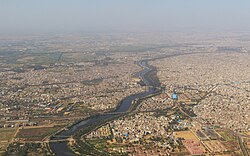
An aerial image of New Delhi, India, one of the world's largest urban areas
Broadly, urbanization is the increasing number of people who live in urban areas. Urbanization refers to both urban population growth and the physical growth of urban areas.[33] According to the United Nations, the global urban population has increased rapidly since 1950, from 751 million to 4.2 billion in 2018, and current trends predict this number will continue to grow.[34] Accompanying this population shift are significant changes in economic flow, culture and lifestyle, and spatial population distribution.[34] Although urbanized areas cover just 3% of the Earth's surface, they nevertheless have a significant impact on land use and land cover change.[35]
Urbanization is important to land use and land cover change for a variety of reasons. In particular, urbanization affects land change elsewhere through the shifting of urban-rural linkages, or the ecological footprint of the transfer of goods and services between urban and rural areas.[36] Increases in urbanization lead to increases in consumption, which puts increased pressure on surrounding rural lands.[36] The outward spread of urban areas can also take over adjacent land formerly used for crop cultivation.[36]
Urbanization additionally affects land cover through the urban heat island effect. Heat islands occur when, due to high concentrations of structures, such as buildings and roads, that absorb and re-emit solar radiation, and low concentrations of vegetative cover, urban areas experience higher temperatures than surrounding areas.[37] The high temperatures associated with heat islands can compromise human health, particularly in low-income areas.[37]
Decline of the Aral Sea
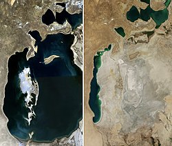
Remote sensing images show changes to the extent of the Aral Sea from 1989 (left) to 2014 (right).
The rapid decline of the Aral Sea is an example how local-scale land use and land change can have compounded impacts on regional climate systems, particularly when human activities heavily disrupt natural climatic cycles, how land change science can be used to map and study such changes.[38] In 1960, the Aral Sea, located in Central Asia, was the world's fourth largest lake.[39] However, a water diversion project, undertaken by the Soviet Union to irrigate arid plains in what is now Kazakhstan, Uzbekistan, and Turkmenistan, resulted in the Aral Sea losing 85% of its land cover and 90% of its volume.[39] The loss of the Aral Sea has had a significant effect on human-environment interactions in the region, including the decimation of the sea's fishing industry and the salinization of agricultural lands by the wind-spread of dried sea salt beds.[38][39]
Additionally, scientists have been able to use technology such as NASA's Moderate Resolution Imaging Spectroradiometer (MODIS) to track changes to the Aral Sea and its surrounding climate over time.[40] This use of modeling and satellite imagery to track human-caused land cover change is characteristic of the scope of land change science.
The urban growth boundary is one form of land-use regulation. For example, Portland, Oregon is required to have an urban growth boundary which contains at least 20,000 acres (81km2) of vacant land. Additionally, Oregon restricts the development of farmland. The regulations are controversial, but an economic analysis concluded that farmland appreciated similarly to the other land.[41]
In colonial America, few regulations were originally put into place regarding the usage of land. As society shifted from rural to urban, public land regulation became important, especially to city governments trying to control industry, commerce, and housing within their boundaries. The first zoning ordinance was passed in New York City in 1916,[42][43] and, by the 1930s, most states had adopted zoning laws. In the 1970s, concerns about the environment and historic preservation led to further regulation.
Today, federal, state, and local governments regulate growth and development through statutory law. The majority of controls on land, however, stem from the actions of private developers and individuals. Judicial decisions and enforcement of private land-use arrangements can reinforce public regulation, and achieve forms and levels of control that regulatory zoning cannot. There is growing concern that land use regulation is a direct cause of housing segregation in the United States today.[44]
1 2 Brown, Daniel G.; etal. (2014). Advancing Land Change Modeling: Opportunities and Research Requirements. Washington, DC: The National Academic Press. pp.11–12. ISBN978-0-309-28833-0.
↑ Brown DG, Verburg PH, Pontius Jr RG, Lange MD (October 2013). "Opportunities to improve impact, integration, and evaluation of land change models". Current Opinion in Environmental Sustainability. 5 (5): 452–457. doi:10.1016/j.cosust.2013.07.012.
1 2 United Nations, Department of Economic and Social Affairs, Population Division (2019). World Urbanization Prospects 2018: Highlights (ST/ESA/SER.A/421).
1 2 3 Middleton, Nick (2019). The Global Casino: An Introduction to Environmental Issues. London & New York: Routledge. pp.179–182. ISBN978-1-315-15840-2.
This page is based on this Wikipedia article Text is available under the CC BY-SA 4.0 license; additional terms may apply. Images, videos and audio are available under their respective licenses.