Related Research Articles
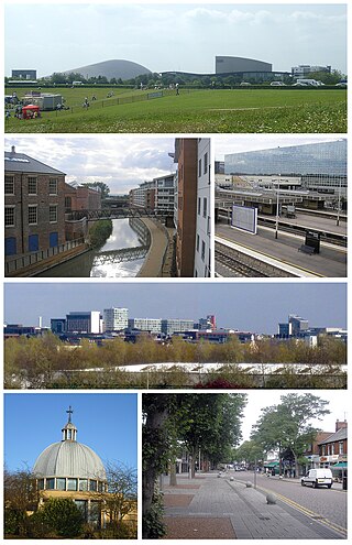
Milton Keynes is a city and the largest settlement in Buckinghamshire, England, about 50 miles (80 km) north-west of London. At the 2021 Census, the population of its urban area was over 256,000. The River Great Ouse forms its northern boundary; a tributary, the River Ouzel, meanders through its linear parks and balancing lakes. Approximately 25% of the urban area is parkland or woodland and includes two Sites of Special Scientific Interest (SSSIs).
Parish councils are civil local authorities found in England which are the lowest tier of local government. They are elected corporate bodies, with variable tax raising powers, and they carry out beneficial public activities in geographical areas known as civil parishes. There are about 10,480 parish and town councils in England. Parish councils may be known by different styles, they may resolve to call themselves a town council, village council, community council, neighbourhood council, or if the parish has city status, it may call itself a city council. However their powers and duties are the same whatever name they carry.

Welwyn Garden City is a town in Hertfordshire, England, 20 miles (32 km) north of London. It was the second garden city in England and one of the first new towns. It is unique in being both a garden city and a new town and exemplifies the physical, social and cultural planning ideals of the periods in which it was built.
Cambourne is a new settlement and civil parish in Cambridgeshire, England, in the district of South Cambridgeshire. It lies on the A428 road between Cambridge, 9 miles (14 km) to the east, and St Neots and Bedford to the west. It comprises the three villages of Great Cambourne, Lower Cambourne and Upper Cambourne. The area is close to Bourn Airfield.

Dunnington is a village and civil parish in the City of York and ceremonial county of North Yorkshire, England. The population of the civil parish was 3,230 at the 2011 Census. The village is approximately 4 miles (6 km) east from York city centre.

Purley on Thames is a village and civil parish in Berkshire, England. Purley is centred 3 miles (4.8 km) north-west of Reading, 1 mile (1.6 km) east of Pangbourne, and 22 miles (35 km) south-east of Oxford. Consequently, Reading is the principal social, economic and cultural centre for the people of Purley. Historically, Purley comprised three separate manors and associated settlements. In the centre there is an historic area named variously Lething or Burley (Domesday) which accommodated traders and craftsmen alongside the main Reading to Oxford road.
Elwick is a village and civil parish in the borough of Hartlepool and the ceremonial county of County Durham, in England. It is situated near the A19 road to the west of Hartlepool. Hartlepool Borough Council governs Elwick. As Elwick is only a small parish it is not able to run itself as its own district. It does have a Parish Council. Elwick was known as a township until 1866, but then was changed to a civil parish status.
VDS is a three-letter abbreviation which may mean:
Buckshaw Village is a 21st-century residential and industrial area between the towns of Chorley and Leyland in Lancashire, England, developed on the site of the former Royal Ordnance Factory (ROF) Chorley. It had a population of 4,000. It is divided between the civil parishes of Euxton (south) and Whittle-le-Woods in Chorley, with the north western part being in Leyland unparished area in South Ribble district.

Alpheton is a village and civil parish in the Babergh district of Suffolk, England. Located on the A134 road about six miles north of Sudbury, in 2005 it had a population of 260, reducing to 256 at the 2011 Census. According to Eilert Ekwall the meaning of the village name is the homestead of Aelfled.
Neighborhood planning is a form of urban planning through which professional urban planners and communities seek to shape new and existing neighborhoods. It can denote the process of creating a physical neighborhood plan, for example via participatory planning, or an ongoing process through which neighborhood affairs are decided.
A village hall is a public building in a rural or suburban community which functions as a community centre without a religious affiliation.
The rural community councils (RCCs) were established in rural England during the twentieth century to promote rural community life.
Red Lodge is a village and civil parish situated in rural Suffolk, England, between Mildenhall and Newmarket, and very close to the A11 and A14 roads.
In England, parish plans are a form of community-led plan.
Medlar-with-Wesham is a civil parish and an electoral ward on the Fylde in Lancashire, England, which contains the town of Wesham. It lies within the Borough of Fylde, and had a population of 3,245 in 1,294 households recorded in the 2001 census. rising to 3,584 at the 2011 Census.

Laverstock is a village and civil parish on the north-east and east outskirts of Salisbury in the ceremonial county of Wiltshire, England. The parish is shaped like a figure 7 and incorporates Ford hamlet, the eastern half of the former manor of Milford, the area near the ancient settlement of Old Sarum, and part of the Hampton Park district on the edge of Salisbury.

Goodwyns is a housing estate in Dorking, a market town in Surrey, England. It is on the return slope of one of two hillsides of the town and adjoins North Holmwood, a green-buffered village. The town centre is about 1.7 miles (2.7 km) away.

Handforth Town Council is the parish council for the civil parish of Handforth in Cheshire, England. Previously known as Handforth Parish Council, it was renamed Handforth Town Council on 31 July 2021.
References
- ↑ "Community Led Planning". ACRE – Action with Communities in Rural England . 2011. Archived from the original on 5 April 2011 – via Internet Archive.
- ↑ "Village Design Statements". Natural England . Archived from the original on 11 November 2007 – via Internet Archive.
- ↑ "Community Led Planning". Rural Community Council of Essex. Retrieved 13 March 2023.