The United Nations Economic Commission for Europe is one of the five regional commissions under the jurisdiction of the United Nations Economic and Social Council. It was established in order to promote economic cooperation and integration among its member states.

In general, a rural area or a countryside is a geographic area that is located outside towns and cities. Typical rural areas have a low population density and small settlements. Agricultural areas and areas with forestry are typically described as rural, as well as other areas lacking substantial development. Different countries have varying definitions of rural for statistical and administrative purposes.

The Katowice-Ostrava metropolitan area is a polycentric metropolitan area in southern Poland and northeastern Czech Republic, centered on the cities of Katowice and Ostrava, and has around 5 million inhabitants. Geographically, it is located mainly in Upper Silesia, with small parts of the area also in the historical regions of Moravia and Lesser Poland. Administratively, it is located in the three administrative units : mainly Silesian Voivodeship and a small western part of Lesser Poland Voivodeship in Poland, and also a small eastern part of Moravian-Silesian Region in the Czech Republic.

The Regional Policy of the European Union (EU), also referred as Cohesion Policy, is a policy with the stated aim of improving the economic well-being of regions in the European Union and also to avoid regional disparities. More than one third of the EU's budget is devoted to this policy, which aims to remove economic, social and territorial disparities across the EU, restructure declining industrial areas and diversify rural areas which have declining agriculture. In doing so, EU regional policy is geared towards making regions more competitive, fostering economic growth and creating new jobs. The policy also has a role to play in wider challenges for the future, including climate change, energy supply and globalisation.
The European Structural and Investment Funds are financial tools governed by a common rulebook, set up to implement the regional policy of the European Union, as well as the structural policy pillars of the Common Agricultural Policy and the Common Fisheries Policy. They aim to reduce regional disparities in income, wealth and opportunities. Europe's poorer regions receive most of the support, but all European regions are eligible for funding under the policy's various funds and programmes. The current framework is set for a period of seven years, from 2021 to 2027.
Multi-level governance is a term used to describe the way power is spread vertically between levels of government and horizontally across multiple quasi-government and non-governmental organizations and actors. This situation develops because countries have multiple levels of government including local, regional, state, national or federal, and many other organisations with interests in policy decisions and outcomes. International governance operates based on multi-level governance principles. Multi-level governance can be distinguished from multi-level government which is when different levels of government share or transfer responsibility amongst each other. Whereas multi-level governance analyses the relationship of different state levels and interaction with different types of actors.'
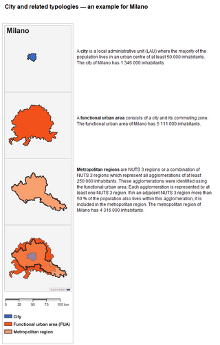
The functional urban area (FUA), previously known as larger urban zone (LUZ), is a measure of the population and expanse of metropolitan and surrounding areas which may or may not be exclusively urban. It consists of a city and its commuting zone, which is a contiguous area of spatial units that have at least 15% of their employed residents working in the city.
Interreg is a series of programmes to stimulate cooperation between regions in and out of the European Union (EU), funded by the European Regional Development Fund. The first Interreg started in 1989. Interreg IV covered the period 2007–2013. Interreg V (2014–2020) covers all 27 EU member states, the EFTA countries, six accession countries and 18 neighbouring countries. It has a budget of EUR 10.1 billion, which represents 2.8% of the total of the European Cohesion Policy budget. Since the non EU countries don't pay EU membership fee, they contribute directly to Interreg, not through ERDF.
Frank Moulaert is Professor of Spatial Planning at the Department of Architecture, Urban Design and Regional Planning at Catholic University of Leuven. He is Director of the Urban and Regional Planning Research Group and chairs the Leuven Space and Society Research Centre at the University. He is also a visiting professor at the School of Architecture, Planning and Landscape, Newcastle University.
The European Spatial Development Perspective (ESDP) is a document approved by the Informal Council of Ministers of Spatial Planning of European Commission in Potsdam in 1999. It is a legally non-binding document forming a policy framework with 60 policy options for all tiers of administration with a planning responsibility. The strategic aim is to achieve a balanced and sustainable spatial development strategy.
Cliff Hague is a British town planning practitioner and Emeritus Professor of Planning and Spatial Development at Heriot-Watt University, Edinburgh. He was educated at Alfred St Elementary School in Manchester, North Manchester Grammar School for Boys (1955–63) and Magdalene College Cambridge (1963–66) where he read Geography, then at the University of Manchester (1966–68) where he was awarded a post-graduate Diploma in Town Planning.

The Ministry for Development, Public Works and Administration of Romania is an institution of the Romanian central public administration, subordinated to the Government of Romania. The Ministry was created on December 22, 2012 by the restructuring of the former Ministry of Regional Development and Tourism (2009–2010) and by taking over the public administration structures and the institutions specialized in this area from the Ministry of Interior Affairs, under the Emergency Ordinance no.96 of 22 December 2012.
Town and country planning in Wales is based on the land use planning system which applies in England. However, the system in Wales has some distinctive features which have arisen because substantial responsibility for town and country planning has been devolved to the Welsh Government (WAG). In particular, Wales now has a Spatial Plan and Welsh Ministers have a duty under the Government of Wales Act 2006 to promote sustainable development.
The European Observation Network for Territorial Development and Cohesion, often shortened as ESPON, is a European funded programme under the objective of "European Territorial Cooperation" of the Cohesion Policy of the European Union. It is co-funded by the European Regional Development Fund - Interreg.

The Katowice urban area, also known as the Upper Silesian urban area, is an urban area/conurbation in southern Poland, centered on Katowice. It is located in the Silesian Voivodeship. The Katowice urban area is the largest urban area in Poland and 22nd largest urban area in the European Union. According to Demographia, its population is 1,903,000.
The European Council of Spatial Planners (ECTP-CEU) is the umbrella organisation for spatial planning institutes in Europe. It was founded in 1985. In June 2014 it had 32 members in 24 European countries. When they join, new member organisations sign an International Agreement on the nature of spatial planning, the responsibilities of planners, common educational standards and a code of conduct. It runs an Awards Scheme every two years, giving prizes for outstanding work in creating attractive places.
Spatial Planning in Serbia is the activity which can be recognized under different names in other countries. The literal translation of the term spatial planning is used in Serbia since the second half of the 20th century, prostor meaning space and planiranje meaning planning. The term of spatial planning appeared for the first time in the name of one Ministry in 2008 - the Ministry of Environment and Spatial Planning which existed until 2012. From 2012 to 2013 the ministry in charge of spatial planning in Serbia was the Ministry of Natural Resources, Mining and Spatial Planning. From 2014 the Ministry in charge of spatial planning is the Ministry of Construction, Transport and Infrastructure with the Sector for Spatial Planning, Urbanism and Housing.
Generally, spatial development is linked to include all the techniques used by planners, geographers and other actors of decision making to facilitate integrated balanced development. Spatial planning for development has no territorial barrier, ranging across continents, regions, nations and local communities. Various forms of spatial development qualities have been attributed mainly by the Developed World, while the Developing World and Cameroon in particular, are still trying to integrate the formula into their system. As such, to understand better spatial development in Cameroon, a brief notion of the African context is necessary.
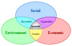
Sustainable land management (SLM) refers to practices and technologies that aim to integrate the management of land, water, and other environmental resources to meet human needs while ensuring long-term sustainability, ecosystem services, biodiversity, and livelihoods. The term is used, for example, in regional planning and soil or environmental protection, as well as in property and estate management.
The Cohesion Fund (CF), one of the five European Structural and Investment Funds of the European Union, provides support to Member States with a gross national income (GNI) per capita below 90% EU-27 average to strengthen the economic, social and territorial cohesion of the EU. Common regulatory provisions apply to the five ESIF funds, along with the Just Transition Fund, the Asylum, Migration and Integration Fund, the Internal Security Fund and the Instrument for Financial Support for Border Management and Visa Policy.