Urban planning in Russia

Last updated

Urban planning in Russia is the practice of urban planning according to the legislation and is influenced by various factors such as historical legacy, traditions, geography and climate and involves various actors including the federal as well as regional and local governments. The direct translation to Russian is Gradoplanirovaniye (Russian : Градопланирование) but also common is the term Gradostraitelstvo (Russian : Градостроительство) which literally translated as urban construction.

Contents

History

During the Kievan Rus' period, settlements which were located in strategic places, such as confluence of rivers or sitting on important routes grew in importance and transformed into towns. Concurrently they became gravity center of political, economic and military power. From the 10th century markets and handicraft trade developed, a process which contributed to the growth of towns and around them grew settlements which were suburbs of the core town, [1] gravitated towards them [2] and were called ( Posad ). In some cases, cities of Kievan Rus' had radial structure made of two parts, one is the Kremlin and the other the Posad. [3] In connection with these processes the number of dwellers in towns increased. These cities of the Kievan Rus' military fortifications built by the princes so that the population can escape there in case of Nomadic raids. [4] The core city fortresses, known as Kremlin were built in strategic places, elevated from its surroundings, often located in the confluence of rivers or lakes. [4] The Kremlins were not only the fortress itself but a defined area in the city center which gathered in it range of buildings of political, religious and social importance. While some where built from wood, they were later rebuilt from stone and were surrounded by moats and earthworks fortifications. [5] In the case of Veliky Novgorod, one of the important cities of ancient Russia, streets were built from north to south and sometimes several buildings were connected to each other forming voids between them. [3] In Ryazan, after 1350, there was a change in the trend of urban planning with clearer divisions based on social status and professional affiliation, which implied on a politically strong prince. [3]

Following the formation of the centralized Russian state and its military as well as its expansion towards the east, new military-defensive towns and cities which were constructed in the newly aquuired lands. [6]

City plan of Veliky Novgorod, dating 1862 Novgorod 1862.jpg
City plan of Veliky Novgorod, dating 1862

The emergence of new cities continued further in the 16th century and 17th century, during the Tsardom of Russia, and during the second half of the 16th century 50 new cities appeared, while by the mid 17th century there were 254 cities in total, of them about 180 had status of Possad. [7] Yet, urban planning concepts and regulations such as location of the buildings relatively to the terrian, sufficient distance between them and accurate parcellation were not integral part of the system. Following the rise to power of Peter I the Great and his Far-fledging reforms, urban planning system in the Russian Empire went through major overhaul with the introduction of new concepts and regulations. Those reforms occurred altogether with the enhancing of the regional and local administration system [8] On 16 January 1721, Articles of Chief Magistrate were published, which laid down the basics principles of city types categorization, ranking them by parameters of geographic location and population. Another major change occurred in the first half of the 18th century with the rising of the "regularity" concept, which called for creation of grid plan cities with emphasized ensembles and geometry trend. [9] The city plans which came into force from now on were geometrically lined, creating perpendicular streets, which was influenced, among others by the philosophy of Descartes by the French military engineer Sebastien Vauban. [8] New city plans were signed off for different cities throughout the Russian Empire such as Tver, Tula, Kaluga, Kostroma, Kolomna, Vladimir, Yaroslavl and Yekaterinburg. [9] The urban planning went into much more details with Emperor Peter the Great, Catherine the Great and Alexander I have put their signatures on various general city plans which regulated the width of central streets, straightened streets and called for high level of aesthetics and composition. [10] The city plans were developed by various architects and planners, among them William Heste, Matvey Kazakov, Ivan Starov, Vasily Bazhenov, Petr Nikitin and others.

Soviet period

Typical Moscow suburb built during Soviet period with highly-dense microdistricts separated by radial roads Kashirskoe shosse.jpg
Typical Moscow suburb built during Soviet period with highly-dense microdistricts separated by radial roads

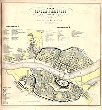
Following the October Revolution and the establishment of the Soviet Union, urban planning in Soviet Russia went through massive changes. Huge emphasis was given to the creation of industrial base and urbanization with mass influx of populations from rural areas to the cities. Old cities grew and expanded beyond their historical borders and completely new cities created from scratch. The Soviet government distanced itself from the old concepts inherited from the Tsarist period and already in 1918, a decree which abolished private ownership in urban areas came into force, [11] practically municipalizing and nationalizing large parts of the housing stocks. While the Soviet government called for the upbringing of the workers and farmers at the expense of the old bourgeoisie, even by 1925 there was no centrally imposed, unified concept of urban planning. [12] Formulating steps were taken in the form of the enactment of the Statue on Urban Land Management of 13 April 1925 which laid down the foundations of the urban planning system which placed the lands and the city plans under the jurisdiction of the city councils which had the authority to issue construction leases based on it. [13] The 1920s and 1930s saw many reforms related to urban planning and new master plans (city plans) for urban settlements across Russia and the other republics of the Soviet Union with the help of large design institutes, among them Moscow's Giprogor (Russian : Гипрогор), Leningrad based Lengiprogor (Russian : Ленгипрогор, Gorstroyproyekt (Russian : Горстройпроект) and Giprograd (Russian : Гипроград). [14] Noteworthy is the Moscow 1935 Master Plan. Another major law regulating and directing the urban planning in the country was the All-Union Law On Regional and City PLanning and law On Preparation and Approval of Plans for Design and Socialist Reconstruction of Cities and Other Populated Places adopted in 1933. [15] The Soviet government pushed for regulation and uniformity of planning and design, standartizing the rules and centrally imposed concepts to all the republics of the Soviet Union. [16] Settlements were planned and treated as centrally planned component being part of the national economic system, often destroying the uniqueness of them in favour of standartization. [17]

The Second World War halted many of the urban planning activities as the authorities have allocated the entire resources to the war efforts, urbanization especially in cities deeper in Russia continued, as a result of the relocation of factories into them, which led to the relocation of population employed in those factories and the construction of new workers' settlements around those cities. [18] As the war management consumed most of Stalin's time and efforts, urban planning decision which previously were handled by him, were not taken care by Chairman of the Presidium of the Supreme Soviet, Mikhail Kalinin. [19] Already before the end of the war, in 1943, city planners began proposing their concepts for the rebuilding of the cities destroyed in the fighting, such as Volgograd. [19]

After the war urban planning politics continued again, alongside the massive reconstruction efforts. The post-war period was marked by active urban planning activities related to the transformation of the historically established settlements together with the emergence of new cities. In order No. 294 of the Committee for Architecture under the Council of Ministers of the USSR issued on 31 of March 1949, special attention was paid to improving the quality of design and planning work, city planning projects. The importance of urban improvement and the introduction of standard projects was emphasized. [20] The meeting of the Central Committee of the CPSU and the Council of Ministers of the USSR convened an All-Union Conference of Builders and City Planners. The meeting which took place [21] in April 1958 discussed the pressing problems of planning and urban development and outlined ways to solve them. In 1959, the relevance of this problem at the 22nd Congress of the CPSU was emphasized by Khrushchev, who advocated for the massive construction of pre-fabricated apartment buildings of 5 floors and nicknamed Khrushchevka , designed by the architect Vitaly Lagutenko in order to overcome to extreme housing deficit. In May 1961 the Third All-Union Congress of Soviet Architects convened and called for accelerating the approval of general city plans. [22] The general tendencies from the 1960s until the dissolution of the Soviet Union saw continued expansion of the outer areas of the cities with construction of even higher apartment buildings nicknamed Brezhnevki . [23]

Russian Federation

1991-2000

Gorsky Microdistrict in Novosibirsk Gorsky Microdistrict, Novosibirsk 13.jpg
Gorsky Microdistrict in Novosibirsk

Following the dissolution of the Soviet Union in December 1991, urban planning system in Russia went through dramatic change. Due to the country's move to a more liberalized, market economy, the political preferences and direction for the urban planning has changed as well with the state needed to address marketization and regionalization issues. [24] The economic policies implemented by successive Russian governments in that period led to spatial inequality by which certain groups in a given city experienced increase in their district while other groups experienced sharp decline. [25] The country went through major changes including in its urban planning system and the ideological layer, of constructing a Socialist city was eliminated, [26] yet the planning pattern of the Soviet period which implied construction of tall buildings with high density continued as in the Soviet period, though with more emphasis on leisure and aesthetics in later periods. In the 1990s-2000s, the rush demand for housing in large cities led to an increase in the height and density of buildings. In all major cities of Russia, 25 or more storey residential buildings began to be built. The so-called “densification development” has become widespread, which increases the load on urban infrastructure and negatively affects the aesthetics of the urban environment. The extensive growth of built-up urban areas and urban sprawl due to the reproduction of Soviet microdistrict development also continued. Another trend is the construction of residential and office real estate in former industrial zones. [27] [28] [29] The economic liberalization also led to the growth of street markets and retail trade activities, either regulated or not. [30]

Settlement patterns

While Russia is the largest country on earth, its population is spread unevenly on the territory. Three fourths of Russia's territory is located in Siberia, Asia, while one fourth is located in European Russia, west of the Ural Mountains, but the population distribution is the opposite, with 75% of the country's population is located at the western, European part of the country, and only about 15 million is located east of the Ural Mountains. [31] The main settlement zone in European Russia had formed in accordance with the patterns of the development of industry and transport route, in cities between Moscow and Saint Petersburg. Nefedova specifies five main zones of settlement and urbanization pattern: [31]

Within the different regions, during the last decades, the rise of agglomarations has taken place which takes places concurrently with the de-population of villages and small towns, thus mass immigration of people from small towns and villages to larger cities, with the boldest example of Moscow. Agglomarations grow as the built-up areas of core cities and nearby settlements adjoins. Most of the agglomarations are located in European Russia rather than in Siberia or the Russian Far East. [32] While the Soviet government encouraged urbanization as part of the mass industrialization, shifting the population from being employed in agriculture in rural areas to industry, mainly heavy one, it also controlled the cities' population, encouraging the spreading of the population and creating huge number of small and mid-sized cities (among them Urban-type settlements). [11] The creation of the urban agglomarations is a process that gathered pace after the dissolution of the Soviet Union and is a result of liberalization of the country's resident registration system which made it easier to move from one place to another, both trends rising from below, mainly people searching access to better paid jobs and higher quality public utilities, and encouruged by the federal government in order to cut costs, increasing effectiveness and optimizing transport and infrastructure development. [33]

Another aspect which characterizes the settlement patterns in Russia is the existence of monotowns and closed cities which are located throughout the country, especially in remote areas with harsh climate or limited infrastructure, are based around single factory associated with heavy industry or defense industry. Their establishment and planning was not based on logical, economic and spatial considerations such as proximity to transport routes or continuation of existing urban areas. [34] In an effort to tackle the economic problem of these types of cities, the Russian Government compelled in 2014 a list of 319 mono towns and divided them into three sub-groups by socio-economic risk: high, medium and low. It also created the Monotown Development Fund as a tool for the development and regulations of these cities in the years to come. [35]

Urban structure

Many of the cities in contemporary Russia have a centralized structure, a legacy of Soviet planning which tended to emphasize the public areas in city center with concentration of governmental and commercial as well as other public functions. Around the very city center are the old periphery districts which have mixture of commercial, residential and transport use. These districts include brick houses and tenement buildings built in the late tsarist period as well as buildings built during Soviet times. In recent decades they are going through waves of reconstruction and gentrification. [36] Around them are vast mono-functional districts which contain residential areas (Microdistrict) and industrial areas mainly of heavy industry, in accordance with the Concentric zone model of urban land use, [11] with radiating out wide, geometrically lined roads [37] separating between them. [25] While the built-up area in the cities is generally dense, some spots of old wooden housing and dacha remain. [25]

Old cities, which were built around a Kremlin, have a clear "old city" part, or a distinctive city center, while cities that were built from scratch or grew from small villages don't have a clear historical core and are more uniform in their urban layout and architecture. Many cities in Russia have high dispersion index which indicates the effectiveness of the distribution pattern across the administrative borders of the city. [38] This is as a result of sprawling whereby high-density residential districts were constructed around factories thus expanding the cities' borders, a process which occurred from the 20s and 30s and kept the pattern during the later years of the Soviet Union, having the effects on the contemporary structure of Russian cities. As a result, in contrast to the Capitalist countries, where the density drops in the suburbs while the peak is at the city centers, in Russia the situation is opposite with the highest urban density is rather at the city edges.

The large cities are characterized by wide arteries separating between districts, containing a peculiar street patterns with low share of street and road network and internal streets which are mostly not connected to the main streets. [39] While all cities in Russia grew and expanded significantly during the early Soviet period with the annexation of surrounded villages and construction of industry and housing at the suburbs, different conditions specific to each city that determined their different urban layout, being more compact or sprawling. [40] Savelyeva divided them into three groups: Extended urban structure, which includes Volgograd, Ufa and Perm, Discrete urban structure which includes Novosibirsk, Kazan, Krasnoyarsk and Nizhny Novgorod and Compact which includes Chelyabinsk, Yekaterinburg, Omsk, Voronezh and Rostov-on-Don. [40]

Russia inherited from the Soviet Union a complex system of urban planning. At the top is the Urban Development Code of the Russian Federation (Russian : Градостроительный Кодекс Российской Федерации), adopted on 29 December 2004 and later amended. [41] The document is used as an umbrella tool which lays down the general concepts. Beneath it are Territorial Comprehensive Schemes and district schemes at the regional and district level. At the municipal level there are city plans (Russian : Генеральный план) prepared by the respective planning departments of the city halls and which are then approved by the city councils and at the lowest leve, even more detailed plan for specific territory (Russian : Градостроительный план земельного участка). The master plan (general city plan) is approved by the city council (local parliament) and is the highest binding legal tool within the framework of local legislation concerning urban planning. [42] The town planning regulations is a description specifying the types and parameters of the use of land plots and other objects within a certain territory (zoning). [42]

See also

Related Research Articles

<span class="mw-page-title-main">Suburb</span> Human settlement within a metropolitan area

A suburb is an area within a metropolitan area which often contains most of the area's economic activity, which may include commercial and mixed-use. A suburb can exist either as part of a larger city/urban area or as a separate political entity. The name describes an area that is either more or less densely populated than an inner city. In many metropolitan areas suburbs rise in population during the day and are where most jobs are located; being major commercial and job hubs, many suburbs also exist as separate residential communities within commuting distance of a larger city. Suburbs can have their own political or legal jurisdiction, especially in the United States, but this is not always the case, especially in the United Kingdom, where most suburbs are located within the administrative boundaries of cities. In most English-speaking countries, suburban areas are defined in contrast to central city or inner city areas, but in Australian English and South African English, suburb has become largely synonymous with what is called a "neighborhood" in the U.S., but it is used in contrast with inner city areas.

<span class="mw-page-title-main">Zoning</span> Government policy allowing certain uses of land in different places

In urban planning, zoning is a method in which a municipality or other tier of government divides land into "zones", each of which has a set of regulations for new development that differs from other zones. Zones may be defined for a single use, they may combine several compatible activities by use, or in the case of form-based zoning, the differing regulations may govern the density, size and shape of allowed buildings whatever their use. The planning rules for each zone determine whether planning permission for a given development may be granted. Zoning may specify a variety of outright and conditional uses of land. It may indicate the size and dimensions of lots that land may be subdivided into, or the form and scale of buildings. These guidelines are set in order to guide urban growth and development.

<span class="mw-page-title-main">Metropolitan area</span> Administrative unit of a dense urban core and its satellite cities

A metropolitan area or metro is a region consisting of a densely populated urban agglomeration and its surrounding territories sharing industries, commercial areas, transport network, infrastructures and housing. A metropolitan area usually comprises multiple principal cities, jurisdictions and municipalities: neighborhoods, townships, boroughs, cities, towns, exurbs, suburbs, counties, districts and even states and nations in areas like the eurodistricts. As social, economic and political institutions have changed, metropolitan areas have become key economic and political regions.

<span class="mw-page-title-main">Planned community</span> Carefully developed land

A planned community, planned city, planned town, or planned settlement is any community that was carefully planned from its inception and is typically constructed on previously undeveloped land. This contrasts with settlements that evolve organically.

<span class="mw-page-title-main">Urban geography</span> Subdiscipline of geography concentrating on urban areas

Urban geography is the subdiscipline of geography that derives from a study of cities and urban processes. Urban geographers and urbanists examine various aspects of urban life and the built environment. Scholars, activists, and the public have participated in, studied, and critiqued flows of economic and natural resources, human and non-human bodies, patterns of development and infrastructure, political and institutional activities, governance, decay and renewal, and notions of socio-spatial inclusions, exclusions, and everyday life. Urban geography includes different other fields in geography such as the physical, social, and economic aspects of urban geography. The physical geography of urban environments is essential to understand why a town is placed in a specific area, and how the conditions in the environment play an important role with regards to whether or not the city successfully develops. Social geography examines societal and cultural values, diversity, and other conditions that relate to people in the cities. Economic geography is important to examine the economic and job flow within the urban population. These various aspects involved in studying urban geography are necessary to better understand the layout and planning involved in the development of urban environments worldwide.

Urban planning in the Soviet Bloc countries during the Cold War era was dictated by ideological, political, social as well as economic motives. Unlike the urban development in the Western countries, Soviet-style planning often called for the complete redesigning of cities.

<span class="mw-page-title-main">History of Moscow</span>

The city of Moscow gradually grew around the Moscow Kremlin, beginning in the 14th century. It was the capital of the Grand Duchy of Moscow and then the Tsardom of Russia until the capital was moved to Saint Petersburg by Peter the Great. Moscow was the capital of the Russian Soviet Federative Socialist Republic from 1918, which then became the Soviet Union, and since 1991 has served as capital of the Russian Federation.

<span class="mw-page-title-main">Belgorod</span> City in Belgorod Oblast, Russia

Belgorod is a city that is the administrative center of Belgorod Oblast, Russia, located on the Seversky Donets River, approximately 40 kilometers (25 mi) north of the border with Ukraine. It has a population of 339,978 (2021 Census).

<span class="mw-page-title-main">Land-use planning</span> Process of regulating the use of land by a central authority

Land use planning is the process of regulating the use of land by a central authority. Usually, this is done to promote more desirable social and environmental outcomes as well as a more efficient use of resources. More specifically, the goals of modern land use planning often include environmental conservation, restraint of urban sprawl, minimization of transport costs, prevention of land use conflicts, and a reduction in exposure to pollutants. In the pursuit of these goals, planners assume that regulating the use of land will change the patterns of human behavior, and that these changes are beneficial. The first assumption, that regulating land use changes the patterns of human behavior is widely accepted. However, the second assumption - that these changes are beneficial - is contested, and depends on the location and regulations being discussed.

<span class="mw-page-title-main">Ribbon development</span>

Ribbon development refers to the building of houses along the routes of communications radiating from a human settlement. The resulting linear settlements are clearly visible on land use maps and aerial photographs, giving cities and the countryside a particular character. Such development generated great concern in the United Kingdom during the 1920s and the 1930s as well as in numerous other countries during the decades since.

<span class="mw-page-title-main">Gukovo</span> Town in Rostov Oblast, Russia

Gukovo is a mining town in Rostov Oblast, Russia, located close to the border with Ukraine. Population: 66,648 (2002 Census); 67,336 (1989 Census).

<span class="mw-page-title-main">Microdistrict</span> Residential complex

Microdistrict, or microraion, is a residential complex—a primary structural element of the residential area construction in the Soviet Union and in some post-Soviet and former Socialist states. Residential districts in most of the cities and towns in Russia and the republics of the former Soviet Union were built in accordance with this concept.

Urban, city, or town planning is the discipline of planning which explores several aspects of the built and social environments of municipalities and communities:

<span class="mw-page-title-main">Systematization (Romania)</span> Public housing in Romania

Systematization in Romania was a program of urban planning carried out by the Romanian Communist Party under the leadership of Nicolae Ceaușescu. Ceaușescu was impressed by the ideological mobilization and mass adulation of North Korea under its Juche ideology during his East Asia visit in 1971, and issued the July Theses shortly afterwards.

<span class="mw-page-title-main">Luton/Dunstable urban area</span> Conurbation in Bedfordshire, England, which includes Luton, Dunstable and Houghton Regis

The Luton/Dunstable urban area, according to the Office for National Statistics, is the conurbation including the settlements of Luton, Dunstable and Houghton Regis, in Bedfordshire, East of England.

<span class="mw-page-title-main">Urban planning in China</span>

Urban Planning in China is currently characterized by a top-down approach, high density urban development and extensive urbanization. China's urban planning philosophies and practices have undergone multiple transitions due to governance and economic structure changes throughout the nation's extensive history. The founding of the People's Republic of China in 1949 marks the beginning of three recent historical stages of urban planning philosophies and practice that represent a divergence from traditional Chinese urban planning morphologies are broadly categorized as socialist, hybrid and global cities.

<span class="mw-page-title-main">Monotown</span> Town economically cetered around a single industry

A monotown is a city/town whose economy is dominated by a single industry or company. This means that most employments are by the main company.

Unified settlement planning (USP) is the component of regional planning where a unified approach is applied for a region's overall development. The USP approach is most often associated with urban planning practices in India.

<span class="mw-page-title-main">Populated places in Ukraine</span>

In Ukraine, a populated place refers to a structured component of the human settlement system, representing a stationary community within a territorially cohesive and compact area characterized by a significant concentration of population. Its defining attribute is the continuous presence of human inhabitants. Populated places in Ukraine are classified into two primary categories: urban and rural. Urban populated places are cities, whereas rural areas include villages and rural settlements. According to data from the 2001 Ukrainian Census, there are 1,344 urban and 28,621 rural populated places in Ukraine.

<span class="mw-page-title-main">Urban planning in Africa</span>

Urban planning in Africa results from indigenous aesthetics and conceptions of form and function as well as the changes brought on by industrialization, modernization, and colonialism. Before the Berlin Conference of 1884 – 1885, which formalized colonialism in many parts of Africa, indigenous African cities and villages had ordered structures that varied along ethnic and religious lines and according to geography. All land-uses necessary for functioning––markets, religious sites, farms, communal assembly spaces––existed in ordered, rational ways, as did land property practices and laws, many of which changed under colonial control. Urbanity changed significantly from pre-colonial to colonial times, as slavery, Christianity, and a host of other forces caused a change in the population of indigenous urban dwellers.

References

Footnotes

  1. Sheremetov & Lagunin 2016, p. 21.
  2. Lachininsky, Stanislav S.; Sorokin, Ivan S. (2021). "Spatial structure and the development of settlements in the Saint Petersburg agglomeration" (PDF). p. 51.{{cite web}}: CS1 maint: multiple names: authors list (link)
  3. 1 2 3 Darya Lapina (2023). "Социальные и политические основы формирования градостроительства и архитектуры городов Древней Руси". Genesis: исторические исследования (in Russian). 4. doi:10.25136/2409-868X.2023.4.37944. S2CID   258542830.
  4. 1 2 Vasily Schukin. "Древнерусский Город Как Культурная Проблема - Исторический Обзор" (PDF) (in Russian). Jagiellonian University. Retrieved 2023-11-01.{{cite journal}}: Cite journal requires |journal= (help)
  5. Sheremetov & Lagunin 2016, p. 25.
  6. Daniela Szymanska (2004). "Some Problems of Urbanization in Russia" (PDF). Current Politics and Economics of Russia, Eastern and Central Europe: 77. ISSN   1057-2295.
  7. Г.В. Алферова (1989). Русские Города XVI – XVII Веков. Moscow: Стройиздат. pp. 4–5.
  8. 1 2 Milena Zolotareva (2017). "New Trends of Urban Development in Russia in the 18th Century". Journal of Architecture and Urbanism. 41: 71–77. doi: 10.3846/20297955.2017.1296792 . ISSN   2029-7955.
  9. 1 2 Albert J. Schmidt (1989). The Architecture and Planning of Classical Moscow A Cultural History. American Philosophical Society. pp. 4–5. ISBN   9780871691811.
  10. Albert J. Schmidt. "Provincial Russian Urbanism: Shaping Catherine the Great's Imperial Space, 1760–96 and After".
  11. 1 2 3 Kalyukin, Alexander; Kohl, Sebastian (2019). "Continuities and discontinuities of Russian urban housing: The Soviet housing experiment in historical long-term perspective". Urban Studies. 57 (8): 1768–1785. doi: 10.1177/0042098019852326 . hdl: 21.11116/0000-0004-4BBC-5 .
  12. Zile 1963, p. 25.
  13. Zile 1963, p. 24.
  14. Н.Б. Соколов, В.И. Павличенков. "Градостроительство СССР. 1933—1941" (in Russian). Retrieved 2023-11-02.
  15. Zile 1963, p. 33.
  16. Svitlana Shlipchenko (2022-06-09). "Imperial Soviet Narrative in Architecture and Urban Planning, and Politics of Colonization". Heinrich Böll Foundation. Retrieved 2023-11-07.
  17. Jacob Dreyer (2014-06-26). "Maximum city: the vast urban planning projects of Soviet-era Russia are being reborn in modern China". New East Digital Archive. Retrieved 2023-11-08.
  18. Vasily Bolshakov. "Архитектурно-планировочная эволюция Челябинской агломерации" (in Russian). Retrieved 2023-11-14.
  19. 1 2 Dmitrij Chmelnizki. "Soviet Town Planning during the War, 1941 - 1945" . Retrieved 2023-11-10.
  20. Olesya Kisilyova (2021). "История становления градостроительной политики развития малых городов Красноярского края в 1950–1960-е гг". Вестник Кемеровского государственного университета (in Russian). 23 (2): 330. doi: 10.21603/2078-8975-2021-23-2-325-340 .
  21. I. V. Stoyakin (2022). Борьба с архитектурными излишествами: челябинский эпизод (in Russian). Chelyabinsk Interregional Union of Construction Workers. p. 26.
  22. Zile 1963, p. 54.
  23. Marina Obrazovka (2013-12-03). "A look at Soviet-era housing". Russia Beyond. Retrieved 2023-11-06.
  24. Nadir Kinossian (May 2022). "Authoritarian state capitalism: Spatial planning and the megaproject in Russia". Environment and Planning.
  25. 1 2 3 Sonia Hirt & Kiril Stanilov (2009). "Twenty Years of Transition: The Evolution of Urban Planning in Eastern Europe and the Former Soviet Union, 1989-2009" (PDF). Nairobi: UN-Habitat.
  26. Mezentsev, Sergei (2019). "Problems of spatial planning, zoning and urban development in modern Russia". E3S Web of Conferences. 135: 03050. doi: 10.1051/e3sconf/201913503050 .
  27. "Удивительные приключения урбанизма в России". Archived from the original on 2021-07-09. Retrieved 2021-07-06.
  28. "Эксперты: проблема уплотнительной застройки в России нарастает". Archived from the original on 2021-07-09. Retrieved 2021-07-06.
  29. ""Обычно начинают с транспорта"". Archived from the original on 2021-07-09. Retrieved 2021-07-06.
  30. Axenov, Konstantin; Brade, Isolde; Bondarchuk, Evgenij (2006). The Transformation of Urban Space in Post-Soviet Russia. New York: Routledge. pp. 65–75. ISBN   978-0415545846.
  31. 1 2 T. G. Nefedova & O. B. Glezer (2023). "Transformation of Russia's Sociogeographical Space". Reg Res Russ. 13 (1). National Library of Medicine: 142–168. doi:10.1134/S2079970522700538. PMC   10108806 .
  32. E. V. Antonov, N. K. Kurichev, A. I. Treivis (2022). "Shrinking Urban System of the Largest Country: Research Progress and Unsolved Issues". Reg Res Russ. 12 (1): 20–35. doi:10.1134/S2079970522020010. PMC   9244206 .{{cite journal}}: CS1 maint: multiple names: authors list (link)
  33. Kinossian, Nadir. "The Cart before the Horse: The Perils of State-Led Metropolisation in Russia". Europa Regional. 23: 62.
  34. Iuliia Bushmakova (2016). "Redevelopment of Russian Closed Towns: The Example of Zato Zvezdniy" (PDF). Biuletyn Komitetu Przestrzennego Zagospodarowania Kraju PAN: 233. Retrieved 2023-11-09.
  35. Stuvøy, Kirsti; Shirobokova, Irina (2022). "Multiscalar entanglements in the post-socialist city: monotown restructuring, spatial re-ordering and urban inequality in Russia". Eurasian Geography and Economics. 63 (5): 632. doi: 10.1080/15387216.2021.1944246 . hdl: 11250/3007776 .
  36. "Urban Structure". geographyofrussia.com. Retrieved 2023-11-04.
  37. Zile 1963, p. 28.
  38. Saveleva 2022, p. 233.
  39. Ekaterina Saveleva. "Post-Soviet Street Patterns - Measuring Network Connectivity in the Largest Russian Cities" (PDF). Retrieved 2023-11-14.
  40. 1 2 Ekaterina Savelyeva (2023). "Historical contexts for the emergence of various types of city plans in the major regional centers of Russia". Architecton: Proceedings of Higher Education. 2 (82). doi: 10.47055/19904126_2023_2(82)_15 (inactive 31 January 2024).{{cite journal}}: CS1 maint: DOI inactive as of January 2024 (link)
  41. ""Urban Development Code of the Russian Federation"" (PDF). Retrieved 2023-11-01.
  42. 1 2 "Правовое регулирование территориального планирования использования земель городов в Российской Федерации" (in Russian). Law Theses. 2007. Retrieved 2023-11-04.

Bibliography

Further reading

Commons-logo.svg Media related to Urban planning in Russia at Wikimedia Commons