Russia is the largest country in the world, covering over 17,125,191 km2 (6,612,073 sq mi), and encompassing more than one-eighth of Earth's inhabited land area. Russia extends across eleven time zones, and has the most borders of any country in the world, with sixteen sovereign nations.

The Ural Mountains, or simply the Urals, are a mountain range in Eurasia that runs north–south mostly through the Russian Federation, from the coast of the Arctic Ocean to the river Ural and northwestern Kazakhstan. The mountain range forms part of the conventional boundary between the continents of Europe and Asia, marking the separation between European Russia and Siberia. Vaygach Island and the islands of Novaya Zemlya form a further continuation of the chain to the north into the Arctic Ocean. The average altitudes of the Urals are around 1,000–1,300 metres (3,300–4,300 ft), the highest point being Mount Narodnaya, which reaches a height of 1,894 metres (6,214 ft).
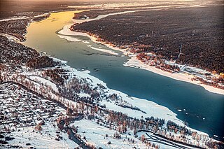
The Ob is a major river in Russia. It is in western Siberia, and with its tributary the Irtysh forms the world's seventh-longest river system, at 5,410 kilometres (3,360 mi). The Ob forms at the confluence of the Biya and Katun which have their origins in the Altai Mountains. It is the westernmost of the three great Siberian rivers that flow into the Arctic Ocean. Its flow is north-westward, then northward.

The Soviet Union incorporated an area of over 22,402,200 square kilometres (8,649,500 sq mi), covering approximately one-sixth of Earth's land surface. It spanned most of Eurasia. Its largest and most populous republic was the Russian SFSR which covered roughly three-quarters of the surface area of the union, including the complete territory of contemporary Russia.
Siberian natural resources refers to resources found in Russian Siberia, in the North Asian Mainland. The Siberian region is rich in resources, including coal, oil and metal ores.

The Putorana Plateau or the Putorana Mountains is a mountainous area in the Russian Federation. It is a large massif or plateau crossed by mountain ranges. The nearest large settlement is Norilsk, where foreign travel is restricted. The city is served by Alykel Airport.

Ural is a geographical region located around the Ural Mountains, between the East European and West Siberian plains. It is considered a part of the Eurasian Steppe, extending approximately from the North to the South; from the Arctic Ocean to the end of the Ural River near Orsk city. The border between Europe and Asia runs along the Eastern side of the Ural Mountains. Ural mostly lies within Russia but also includes a small part of Northwestern Kazakhstan. This is historical, not an official entity, with borders overlapping its Western Volga and Eastern Siberia neighboring regions. At some point in the past, parts of the currently existing Ural region were considered a gateway to Siberia, or even Siberia itself, and were combined with the Volga administrative the divisions. Today, there are two official namesake entities: the Ural Federal District and the Ural economic region. While the latter follows the historical borders, the former is a political product; the District omits Western Ural and includes Western Siberia instead.

The Baraba steppe or Baraba Lowland, is a plain in western Siberia. It is named after Baraba Tatars, its indigenous inhabitants.

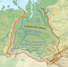
Western Siberia or West Siberia is a region in North Asia. It is part of the wider region of Siberia that is mostly located in the Russian Federation, with a Southern part in Kazakhstan. It lies between the Ural region and the Yenisei River, which conventionally divides Siberia into two halves.
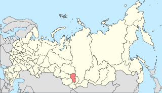
South Central Siberia is a geographical region in North Asia, just north of the meeting point between Russia, China, Kazakhstan and Mongolia.
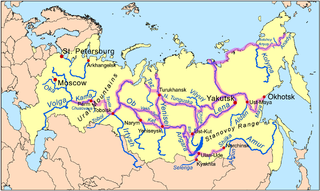
Siberian River Routes were the main ways of communication in Russian Siberia before the 1730s, when roads began to be built. The rivers were also of primary importance in the process of Russian conquest and exploration of vast Siberian territories eastwards. Since the three great Siberian rivers, the Ob, the Yenisey, and the Lena all flow into the Arctic Ocean, the aim was to find parts or branches of these rivers that flow approximately east-west and find short portages between them. Since Siberia is relatively flat, portages were usually short. Despite resistance from the Siberian tribes, Russian Cossacks were able to expand from the Urals to the Pacific in only 57 years (1582-1639). These river routes were crucial in the first years of the Siberian fur trade as the furs were easier to transport over water than land. The rivers connected the major fur gathering centers and provided for relatively quick transport between them.

The North Siberian Lowland, also known as Taymyr Lowland, is a plain with a relatively flat relief separating the Byrranga Mountains of the Taymyr Peninsula in the north from the Central Siberian Plateau in the south. To the southeast of the Olenyok basin the lowland merges with the Central Yakutian Lowland.

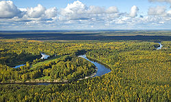
The West Siberian taiga ecoregion covers the West Siberian Plain in Russia, from the Ural Mountains in the west to the Yenisei River in the east, and roughly from 56° N to 66° N latitude. It is a vast, flat lowland region of boreal forests (taiga), and wetlands, covering an area about 1,800 km west–east, by 1,000 km north–south.
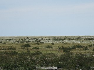
The East Siberian Lowland, also known as Yana-Kolyma Lowland, is a vast plain in North-eastern Siberia, Russia. The territory of the lowland is one of the Great Russian Regions. Administratively, it is a part of the Sakha Republic (Yakutia).
The Tunguska Plateau is a mountain plateau in Krasnoyarsk Krai, Siberia, Russia. It is a part of the Central Siberian Plateau. The plateau is located in a largely uninhabited area. This area was abandoned in 2006.

The Kulunda Steppe or Kulunda Plain is an alluvial plain in Russia and Kazakhstan. It is an important agricultural region in Western Siberia.

Ishim Steppe is a plain in the southern part of Western Siberia, between the Irtysh and Tobol rivers. Administratively it is part of Kurgan, Tyumen, and Omsk oblasts in Russia, and the North Kazakhstan Region in Kazakhstan.

Siberian Uvaly is a hilly region in the central part of the West Siberian Plain, Russia.

The Ob Plateau, is one of the great plateaus of Siberia. Administratively it falls within Altai Krai and Novosibirsk Oblast, Siberian Federal District, Russia. The plateau is named after the Ob River and is part of its basin.

The Bagan is a river in Novosibirsk Oblast, Russia. The river is 364 kilometres (226 mi) long and has a catchment area of 10,700 square kilometres (4,100 sq mi).
