
Russia is the largest country in the world, covering over 17,125,191 km2 (6,612,073 sq mi), and encompassing more than one-eighth of Earth's inhabited land area. Russia extends across eleven time zones, and has the most borders of any country in the world, with sixteen sovereign nations.
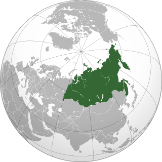
North Asia or Northern Asia is the northern region of Asia, which is defined in geographical terms and consists of three federal districts of Russia: Ural, Siberian, and the Far Eastern. The region forms the bulk of the Asian part of Russia. North Asia is bordered by the Arctic Ocean to its north; by Eastern Europe to its west; by Central Asia and East Asia to its south; and by the Pacific Ocean and Northern America to its east. It covers an area of 13,100,000 square kilometres (5,100,000 sq mi), or 8.8% of Earth's total land area; and is the largest subregion of Asia by area, occupying approx. 29.4% of Asia's land area, but is also the least populated, with a population of around 37 million, accounting for merely 0.74% of Asia's population.

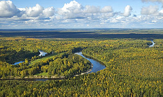
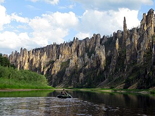
The Lena is a river in the Russian Far East and is the easternmost river of the three, great rivers of Siberia, including the River Ob and the River Yenisey, which flow into the Arctic Ocean. The Lena river is 4,294 km (2,668 mi) long and has a capacious drainage basin of 2,490,000 km2 (960,000 sq mi); thus the Lena is the eleventh-longest river in the world and the longest river entirely within Russia. Geographically, permafrost is the type of soil that underlies most of the Lena river's catchment, twenty per cent (20%) of which is continuous.
The West Siberian Plain is a large plain that occupies the western portion of Siberia, between the Ural Mountains in the west and the Yenisei River in the east, and the Altai Mountains on the southeast. Much of the plain is poorly drained and consists of some of the world's largest swamps and floodplains. Important cities include Chelyabinsk, Novosibirsk, Omsk, and Tomsk, as well as Surgut and Nizhnevartovsk.
Siberian natural resources refers to resources found in Russian Siberia, in the North Asian Mainland. The Siberian region is rich in resources, including coal, oil and metal ores.

The Putorana Plateau or the Putorana Mountains is a mountainous area in the Russian Federation. It is a large massif or plateau crossed by mountain ranges. The nearest large settlement is Norilsk, where foreign travel is restricted. The city is served by Alykel Airport.

Aleksander Piotr Czekanowski, or Aleksandr Lavrentyevich Chekanovsky was a Polish geologist and explorer of Siberia during his exile after participating in the January Uprising. He took part in and later led several expeditions, surveying and mapping the geology of Eastern Siberia. He was released from exile in 1875, and in 1876 took up the post of custodian in the Mineralogical Museum of the Academy of Sciences.
The Kuta is a Siberian river north of Lake Baikal in Irkutsk Oblast, Russia, that flows into the Lena at Ust-Kut. With its right tributary, the Kupa, it forms a ‘T’ shape with the flat head pointing west and the point at Ust-Kut. The river is 408 kilometres (254 mi) long and its basin is about 12,500 square kilometres (4,800 sq mi).

The Stanovoy Highlands or Stanovoy Uplands is a mountain range in the Transbaikal region of Siberia, Russia.
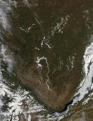
The Lena Plateau, also known as Prilensky Plateau, is one of the great plateaus of Siberia. Administratively it is mostly within the Sakha Republic (Yakutia), with a small sector in the Irkutsk Oblast, Far Eastern Federal District, Russia. The plateau is named after the Lena River, which flows across it.

The Vilyuy Plateau is a mountain plateau in Krasnoyarsk Krai and the Sakha Republic (Yakutia), Siberia, Russia. It is a part of the Central Siberian Plateau and it is made up mainly of the upper course section of the Vilyuy River.

The Central Yakutian Lowland or the Central Yakutian Lowlands, also known as the Central Yakut Plain or the Vilyuy Lowland, is a low alluvial plain in Siberia, Russia.

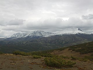
The South Siberian Mountains are one of the largest mountain systems of the Russian Federation. The total area of the system of mountain ranges is more than 1.5 million km². The South Siberian Mountains are located in the Siberian and Far Eastern Federal Districts of Russia, as well as partly in Mongolia. The territory of the mountain system is one of the Great Russian Regions.

The Great Russian Regions are eight geomorphological regions of the Russian Federation displaying characteristic forms of relief. Seven of them are parts of Siberia, located east of the Ural Mountains.

The Yenisey Range is a range of mountains in Siberia. Administratively the range is part of the Krasnoyarsk Krai of the Russian Federation. The nearest town is Severo-Yeniseysk.
The Tunguska Plateau is a mountain plateau in Krasnoyarsk Krai, Siberia, Russia. It is a part of the Central Siberian Plateau. The plateau is located in a largely uninhabited area. This area was abandoned in 2006.

The Primorsky Range is a range of mountains in Southern Siberia, part of the South Siberian Mountains. Administratively the range belongs to the Irkutsk Oblast, Russian Federation. The settlement of Buguldeyka, Olkhonsky District, is located in the range area.
The Lena-Angara Plateau, is a plateau in Siberia. Administratively it is in the Irkutsk Oblast, Russian Federation. The plateau is named after the Lena and Angara rivers, of which it forms the watershed. Rivers on the plateau flow mostly in a south–north direction.
The North Baikal Highlands are a mountainous area in Eastern Siberia, Russia. Administratively the territory of the uplands is part of Buryatia and Irkutsk Oblast.
The Angara Range is a mountain range in Krasnoyarsk Krai and Irkutsk Oblast, Russia, part of the Central Siberian Plateau.


