East Coast of the United States

Last updated

East Coast of the United States
Eastcoastmapallstates.svg
The East Coast of the United States. States with a coastline on the Atlantic Ocean are highlighted in dark blue. States considered part of the East Coast without a coastline are highlighted in light blue.
Country Flag of the United States (23px).png  United States
Principal cities Portland (Maine)
Boston
Providence
Hartford
New York City
Newark
Philadelphia
Baltimore
Washington, D.C.
Richmond
Virginia Beach
Raleigh
Charlotte
Charleston
Atlanta
Jacksonville
Orlando
Tampa
Miami
Largest city New York City
Largest metropolitan area New York metropolitan area
Population
 (2017 estimate)
  Total118,042,627 [1]
Time zone UTC−05:00 (Eastern)
  Summer (DST) UTC−04:00 (EDT)

The East Coast of the United States, also known as the Eastern Seaboard, the Atlantic Coast, and the Atlantic Seaboard, is the region encompassing the coastline where the Eastern United States meets the Atlantic Ocean. The Thirteen Colonies, which formed the United States in 1776 were located on this coast, and it has played an important role in the development of the United States.

Contents

The region is generally understood to include the U.S. states that border the Atlantic Ocean: Connecticut, Delaware, Florida, Georgia, Maine, Maryland, Massachusetts, New Hampshire, New Jersey, New York, North Carolina, Rhode Island, South Carolina, and Virginia, as well as the federal capital of Washington, D.C., and non-coastline states: Pennsylvania, Vermont, and West Virginia. [2]

Toponymy and composition

The place name East Coast derives from the idea that the contiguous 48 states are defined by two major coastlines, one at the western edge and one on the eastern edge. Other terms for referring to this area include the Eastern Seaboard, which is another term for coastline, [3] Atlantic Coast, and Atlantic Seaboard because the coastline lies along the Atlantic Ocean.

The 14 states that have a shoreline on the Atlantic Ocean are (from north to south): Maine, New Hampshire, Massachusetts, Rhode Island, Connecticut, New York, New Jersey, Delaware, Maryland, Virginia, North Carolina, South Carolina, Georgia, and Florida. [4] Pennsylvania and Washington, D.C. border the Delaware River and the Potomac River, respectively, both of which are tidal arms of the Atlantic Ocean.

Colonial history

The original Thirteen Colonies of Great Britain in North America all lay along the East Coast. [lower-alpha 1]

Two additional U.S. states on the East Coast were not among the original Thirteen Colonies: Maine became part of the English Colony of Massachusetts in 1677 [5] and Florida was held by the British from the end of the French and Indian War until 1781 and was part of New Spain until 1821.

In present-day Florida, Spanish explorer Juan Ponce de León made the first textual records of the state during his 1513 voyage. The state was initially named for Ponce de Ponce de León, who called the peninsula La Pascua Florida in recognition of the verdant landscape and because it was the Easter season. [6]

Delaware Colony and the provinces of New Jersey, New York, and Pennsylvania had been colonized by the Dutch as New Netherland until they were ceded to the British in the mid- to late-17th century.[ citation needed ]Until 1791, Vermont was an independent nation as the Vermont Republic.

Geography and climate

Climate map of the contiguous United States, according to the Trewartha climate classification US trewartha.svg
Climate map of the contiguous United States, according to the Trewartha climate classification
Aerial view of the Virginia Beach entrance to the Chesapeake Bay Bridge-Tunnel AerialviewoftheentrancetotheChesapeakeBayBridgeTunnel.jpg
Aerial view of the Virginia Beach entrance to the Chesapeake Bay Bridge–Tunnel
South Mountain in eastern Pennsylvania with Allentown in the foreground in December 2010 Allentown viewed from Egypt.jpg
South Mountain in eastern Pennsylvania with Allentown in the foreground in December 2010
The Fulton Chain of Lakes in Adirondack Park in Upstate New York in August 2007 4thlakesunrise.jpg
The Fulton Chain of Lakes in Adirondack Park in Upstate New York in August 2007

Three basic climate regions occur on the East Coast according to the Köppen climate classification and four occur according to the Trewartha climate classification from north to south based on the monthly mean temperature of the coldest month (January) and the number of months averaging above 50 °F (10 °C), respectively.

The region from northern Maine and Upstate New York south to most of Connecticut, most of northern New Jersey (except for areas close enough to New York City), most of Pennsylvania, and western Maryland has a humid continental climate (Dfa/Dfb/Dc), with warm-to-hot summers, cold and snowy winters with at least one month averaging below freezing, and four to seven months with mean temperatures warmer than 50 °F.

The area from Martha's Vineyard and extreme SW Rhode Island to southern Delaware and western North Carolina has a warm temperate climate (Cfa Köppen/Do Trewartha) with long and hot summers with at least one month over 22°C (71.6°F), cool winters with all months over freezing, and six to seven months above 50°F. Although winter precipitation is more likely to fall as rain than as snow, occasional heavy snow is possible.

The area from the southern Delmarva Peninsula, southeast Virginia, and central North Carolina south to central Florida is humid subtropical (Cfa/Cf), with hot and rainy summers, mild and drier winters, and eight to twelve months above 50°F. Urban heat island exclaves of this zone are found north of this area in Baltimore and Washington, D.C.

The region of Florida from the south-central region of the state south to the Florida Keys has a tropical climate (Af/Aw/Ar) that is frost-free, warm to hot all year, and all of the 12 months of the year average above 18 °C (64.4 °F). This region of Florida is the only tropical climate in the continental U.S.

The least common climate on the East Coast is the oceanic (Cfb/Do), which is only found on Block Island, Nantucket, and areas of Cape Cod, and in areas of the southern Appalachian Mountains. This zone has all monthly averages between 0 and 22 °C and six to seven months above 50 °F. Although winter precipitation is more likely to fall as rain than as snow, occasional heavy snow is possible.

Seasonally, average monthly precipitation ranges from a slight late fall (November) maximum from Massachusetts north to Portland, Maine to a slight summer maximum in the Mid-Atlantic states from southern Connecticut south to Virginia at Wilmington, Delaware and Norfolk, Virginia, to a more pronounced summer maximum from Cape Hatteras in North Carolina, southward along the Southeastern United States coast to Savannah, Georgia. The Florida peninsula has a sharp wet-summer/dry-winter pattern, with 60 to 70% of precipitation falling between June and October in an average year and a dry, and sunny late fall, winter, and early spring.

Although landfalls are rare, the Eastern Seaboard is susceptible to hurricanes in the Atlantic hurricane season, officially running from June 1 to November 30, although hurricanes can occur before or after these dates. [7] Hurricanes Hazel, Hugo, Bob, Isabel, Irene, and Sandy, and most recently Florence, Isaias, Henri, and Ida are some of the more significant storms to have affected the region.

The East Coast, with the exception of eastern Maine, is a low-relief, passive margin coast. [8] It has been shaped by the Pleistocene glaciation in the far northern areas in New England, with offshore islands such as Nantucket, Martha's Vineyard, Block Island, and Fishers Island. From northern New Jersey southward, the coastal plain broadens southwards, separated from the Piedmont region by the Atlantic Seaboard fall line of the East Coast rivers, often marking the head of navigation and prominent sites of cities.

The coastal areas from Long Island south to Florida are often made up of barrier islands that front the coastal areas, with the long stretches of sandy beaches. Many of the larger capes along the lower East Coast are in fact barrier islands, like the Outer Banks of North Carolina and Cape Canaveral, Florida. The Florida Keys are made up of limestone coral and provide the only coral reefs on the U.S. mainland.

Demographics

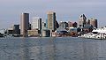
In 2010, the population of the states that have shoreline on the East Coast was estimated at 112,642,503 (36% of the country's total population). New York City is both the largest city and the largest metropolitan area on the East Coast. The East Coast is the most populated coastal area in the United States. [9]

Major East Coast cities and metropolitan areas
CityCity Population (2018 est.)Metro Population (2018 est.)State
Old Town Alexandria from George Washington Masonic National Memorial.jpg
Alexandria
159,4286,216,589Flag of Virginia.svg  Virginia
Allentown.jpg
Allentown
125,845861,889Flag of Pennsylvania.svg  Pennsylvania
Atlanta Downtown July 2010.JPG
Atlanta
498,0445,949,951Flag of Georgia (U.S. state).svg  Georgia
Augusta Georgia Broad Street Lamar Building.jpg
Augusta
196,939600,151Flag of Georgia (U.S. state).svg  Georgia
Bmore skyline inner harbor.jpg
Baltimore
602,4952,802,789Flag of Maryland.svg  Maryland
Boston Skyline (193150499).jpeg
Boston
694,5834,628,910Flag of Massachusetts.svg  Massachusetts
View of Downtown Bridgeport from stairs next to Cabaret Theater.JPG
Bridgeport
144,900939,904Flag of Connecticut.svg  Connecticut
Edmondston-Alston with carriage tour.jpg
Charleston
136,208802,122Flag of South Carolina.svg  South Carolina
Uptown Charlotte 2018 taking by DJI Phantom 4 pro.jpg
Charlotte
872,4982,636,883Flag of North Carolina.svg  North Carolina
Saint Benedict's Parish (Chesapeake, Virginia) - exterior 2.jpg
Chesapeake
244,8351,672,319Flag of Virginia.svg  Virginia
Metropolitan Columbia.jpg
Columbia, MD
103,4676,216,589Flag of Maryland.svg  Maryland
Fall skyline of Columbia SC from Arsenal Hill.jpg
Columbia, SC
133,451838,433Flag of South Carolina.svg  South Carolina
Coral Springs downtown January 2019.jpg
Coral Springs
133,5075,762,717Flag of Florida.svg  Florida
SKYL032 Back Porch Skyline DiscoverDurham.jpg
Durham
264,3102,106,463Flag of North Carolina.svg  North Carolina
TheEdisonTower.jpg
Edison
100,69319,979,477Flag of New Jersey.svg  New Jersey
35412Elizabethfromabove.jpg
Elizabeth
128,88519,979,477Flag of New Jersey.svg  New Jersey
Fayetteville, NC Downtown Skyline.jpg
Fayetteville
211,657526,719Flag of North Carolina.svg  North Carolina
Skyline of Fort Lauderdale, Nov-15.jpg
Fort Lauderdale
182,5955,762,717Flag of Florida.svg  Florida
Mid-Atlantic Federal Credit Union, Germantown, Maryland, May 24, 2014.JPG
Germantown
90,4946,216,589Flag of Maryland.svg  Maryland
Greenville aerial skyline.JPG
Greenville
70,635920,477Flag of South Carolina.svg  South Carolina
Fort Monroe Aerial.jpg
Hampton
134,5101,672,319Flag of Virginia.svg  Virginia
Hartford CT (cropped).JPG

Hartford

122,1051,211,324Flag of Connecticut.svg  Connecticut
Palm Ave-Hialeah - panoramio.jpg
Hialeah
238,9425,828,191Flag of Florida.svg  Florida
Hollywood FL Hollywood Blvd HD01.jpg
Hollywood
154,8235,762,717Flag of Florida.svg  Florida
DowntownJax1.jpg
Jacksonville
903,8891,523,615Flag of Florida.svg  Florida
Jersey City skyline - June 2017.jpg
Jersey City
265,54919,979,477Flag of New Jersey.svg  New Jersey
Downtown Miami (8204604490).jpg
Miami
470,9146,158,824Flag of Florida.svg  Florida
Miami Gardens FL Sunshine State Arch 01.JPG
Miami Gardens
113,0695,762,717Flag of Florida.svg  Florida
Miramar, Florida neighborhood.png
Miramar
140,8235,762,717Flag of Florida.svg  Florida
New Haven from East Rock cropped.jpg
New Haven
130,418862,477Flag of Connecticut.svg  Connecticut
Manhattan - Staten Island Ferry, New York, NY, USA - August 19, 2015 05.jpg
New York City
8,398,74819,979,477Flag of New York.svg  New York
Newark October 2016 panorama.jpg
Newark
282,09019,979,477Flag of New Jersey.svg  New Jersey
Downtown Newport News.jpg
Newport News
179,2251,672,319Flag of Virginia.svg  Virginia
Skyline of Downtown Norfolk Looking Towards Portsmouth.jpg
Norfolk
244,0761,672,319Flag of Virginia.svg  Virginia
The city beautiful.jpg
Orlando
285,7132,387,138Flag of Florida.svg  Florida
CR514 East - Road Shade (29271012308).jpg
Palm Bay
114,194543,376Flag of Florida.svg  Florida
Downtown-paterson-nj2.jpg
Paterson
145,62719,979,477Flag of New Jersey.svg  New Jersey
BCC South Campus - panoramio.jpg
Pembroke Pines
172,3745,762,717Flag of Florida.svg  Florida
Philadelphia skyline from South Street Bridge January 2020.jpeg
Philadelphia
1,584,1386,096,120Flag of Pennsylvania.svg  Pennsylvania
Duquesne Incline (50076338942) (cropped).jpg
Pittsburgh
302,9712,370,930Flag of Pennsylvania.svg  Pennsylvania
Briney Avenue, Pompano Beach - Panorama.jpg
Pompano Beach
111,9545,762,717Flag of Florida.svg  Florida
Portland Waterfront.jpeg
Portland
66,417538,500Flag of Maine.svg  Maine
US Navy 030820-N-9851B-011 Tug boats guide USS Harry S. Truman (CVN 75) up the Elizabeth River, past Portsmouth landmarks.jpg
Portsmouth
94,6321,672,319Flag of Virginia.svg  Virginia
Raleigh Skyline.jpg
Raleigh
469,2981,337,331Flag of North Carolina.svg  North Carolina
Psl golf course.jpg
Port St. Lucie
195,248438,095Flag of Florida.svg  Florida
Providence RI skyline2.jpg
Providence
179,3351,604,291Flag of Rhode Island.svg  Rhode Island
Falls of the James, Downtown Richmond, Virginia, 2008.JPG
Richmond
228,7831,260,029Flag of Virginia.svg  Virginia
Savannah river street.jpg
Savannah
145,862389,494Flag of Georgia (U.S. state).svg  Georgia
Springfield-MA.jpg
Springfield
153,606631,982Flag of Massachusetts.svg  Massachusetts
Stamford Connecticut Skyline Aug 2017.jpg
Stamford
129,775916,829Flag of Connecticut.svg  Connecticut
Virginia Beach from Fishing Pier.jpg
Virginia Beach
450,1381,725,246Flag of Virginia.svg  Virginia
WashMonument WhiteHouse.jpg
Washington, D.C.
705,7496,216,589Flag of Washington, D.C.svg  District of Columbia
West Palm Beach Aerial November 2014 photo D Ramey Logan.jpg
West Palm Beach
111,3985,762,717Flag of Florida.svg  Florida
Wilmington Delaware skyline.jpg
Wilmington, DE
70,6356,069,875Flag of Delaware.svg  Delaware
Wilmington, North Carolina along the Cape Fear River - panoramio.jpg
Wilmington, NC
122,607282,573Flag of North Carolina.svg  North Carolina
Jonathan Dunham House WoodbridgeNJ Built1671.JPG
Woodbridge
100,45019,979,477Flag of New Jersey.svg  New Jersey

Transportation

Philadelphia International Airport in Philadelphia in June 2007 Philadelphia International Airport.jpg
Philadelphia International Airport in Philadelphia in June 2007

The primary Interstate Highway along the East Coast is Interstate 95, completed in 2018, [10] [11] which replaced the historic U.S. Route 1 (Atlantic Highway), the original federal highway that traversed all East Coast states, except Delaware. [12]

By water, the East Coast is connected from Boston, Massachusetts to Miami, Florida, by the Intracoastal Waterway, also known as the East Coast Canal, which was completed in 1912. [13] [14] Amtrak's Downeaster and Northeast Regional offer the main passenger rail service on the Seaboard. The Acela Express offers the only high-speed rail passenger service in the Americas. Between New York and Boston the Acela Express has up to a 54% share of the combined train and air passenger market. [15] [16]

Some of the largest airports in the United States are located along the East Coast of the United States, such as John F. Kennedy International Airport in Queens, New York City, Logan International Airport in Boston, Newark Liberty Airport in Newark, New Jersey, Philadelphia International Airport in Philadelphia, Baltimore–Washington International Airport near Baltimore, Dulles International Airport near Washington, D.C., Hartsfield–Jackson International Airport in Atlanta, Miami International Airport in Miami, Charlotte Douglas International Airport in Charlotte, North Carolina, Tampa International Airport in Tampa, and Orlando International Airport in Orlando, Florida.

Culture

BiscayneBayPanorama.jpg
Panoramic view of Biscayne Bay from PortMiami with Downtown Miami (on left) and Miami Beach (in background on right)
The fast-paced streets of New York City, the largest city in the United States, in January 2020 Fast-Paced Streets of New York City.jpg
The fast-paced streets of New York City, the largest city in the United States, in January 2020

As the first spot in the United States that immigrants arrived and the close proximity of Europe, the Caribbean, and Latin America, the East Coast is home to a diverse population and home to multi-cultures when compared to the rest of the U.S. From the strong Latin culture in southern Florida, to the 200-year-old Gullah culture of the low country coastal islands of Georgia and South Carolina, to the many historic cities in the Mid-Atlantic, where a strong English, German, Italian, Irish, and French culture are present, the East Coast is significantly more diverse than the rest of the United States. Numerous Chinatowns in New York City, and Little Havana in Miami, are examples of such cultural centers in the bigger cities.

The East Coast is home to much of the political and financial power and a center for resort and travel destinations in the United States. New York City is the most populous city in the country and a major world financial center. Seventy-one of the world's Fortune 500 companies have their corporate headquarters in New York City, while Midtown Manhattan, with 400 million square feet of office space in 2018, is the largest central business district in the world. Washington, D.C. is the federal capital and political nerve center of the United States. Many organizations such as defense contractors, civilian contractors, nonprofit organizations, lobbying firms, trade unions, industry trade groups and professional associations have their headquarters in or near Washington, D.C., in order to be close to the federal government.

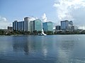
Miami is one of the top domestic and international travel destinations in the United States. Miami is the warmest major city in the continental United States in winter, which contributes to it being a major tourism hub for international visitors. Miami has one of the largest concentrations of international banks in the United States, and the third-largest skyline in the U.S. with over 439 high-rises, 68 of which exceed 490 ft (149 m). Port of Miami is the busiest cruise port in the world in both passenger traffic and cruise lines, with over 5.5 million cruise passengers passing through the port each year. The center for tropical plant culture and research in the United States is based in Miami at Fairchild Tropical Botanic Garden. The state of Florida is the second-largest producer of oranges in the world behind Brazil.

See also

Notes

  1. Those colonies were New Hampshire, Massachusetts Bay, Rhode Island and Providence Plantations, Connecticut, New York, New Jersey, Pennsylvania, Delaware, Maryland, Virginia, North Carolina, South Carolina, and Georgia. While Pennsylvania is not directly along the Atlantic shoreline, it borders the tidal portion of the Delaware River and the city of Philadelphia was a major seaport.

Related Research Articles

<span class="mw-page-title-main">U.S. Route 1</span> Numbered U.S. Highway in the United States

U.S. Route 1 or U.S. Highway 1 (US 1) is a major north–south United States Numbered Highway that serves the East Coast of the United States. It runs 2,370 miles (3,810 km) from Key West, Florida, north to Fort Kent, Maine, at the Canadian border, making it the longest north–south road in the United States. US 1 is generally paralleled by Interstate 95 (I-95), though US 1 is significantly farther west and inland between Jacksonville, Florida, and Petersburg, Virginia, while I-95 is closer to the coastline. In contrast, US 1 in Maine is much closer to the coast than I-95, which runs farther inland than US 1. The route connects most of the major cities of the East Coast from the Southeastern United States to New England, including Miami, Jacksonville, Augusta, Raleigh, Richmond, Washington, D.C., Baltimore, Philadelphia, Newark, New York City, New Haven, Providence, Boston, and Portland.

<span class="mw-page-title-main">Interstate 95</span> U.S. East Coast Interstate Highway

Interstate 95 (I-95) is the main north–south Interstate Highway on the East Coast of the United States, running from U.S. Route 1 (US 1) in Miami, Florida, north to the Houlton–Woodstock Border Crossing between Maine and the Canadian province of New Brunswick. The highway largely parallels the Atlantic coast and US 1, except for the portion between Savannah, Georgia, and Washington, D.C., and the portion between Portland and Houlton in Maine, both of which follow a more direct inland route.

<span class="mw-page-title-main">Eastern United States</span> Geographic region

The Eastern United States, often abbreviated as simply the East, is a macroregion of the United States located to the east of the Mississippi River. It includes 26 states and Washington, D.C., the national capital.

<span class="mw-page-title-main">Hurricane Donna</span> Category 4 Atlantic hurricane in 1960

Hurricane Donna, known in Puerto Rico as Hurricane San Lorenzo, was the strongest hurricane of the 1960 Atlantic hurricane season, and caused severe damage to the Lesser Antilles, the Greater Antilles, and the East Coast of the United States, especially Florida, in August–September. The fifth tropical cyclone, third hurricane, and first major hurricane of the season, Donna developed south of Cape Verde on August 29, spawned by a tropical wave to which 63 deaths from a plane crash in Senegal were attributed. The depression strengthened into Tropical Storm Donna by the following day. Donna moved west-northwestward at roughly 20 mph (32 km/h) and by September 1, it reached hurricane status. Over the next three days, Donna deepened significantly and reached maximum sustained winds of 130 mph (210 km/h) on September 4. Thereafter, it maintained intensity as it struck the Lesser Antilles later that day. On Sint Maarten, the storm left a quarter of the island's population homeless and killed seven people. An additional five deaths were reported in Anguilla, and there were seven other fatalities throughout the Virgin Islands. In Puerto Rico, severe flash flooding led to 107 fatalities, 85 of them in Humacao alone.

<span class="mw-page-title-main">Hurricane Gloria</span> Category 4 Atlantic hurricane in 1985

Hurricane Gloria was a powerful hurricane that caused significant damage along the east coast of the United States and in Atlantic Canada during the 1985 Atlantic hurricane season. It was the first significant tropical cyclone to strike the northeastern United States since Hurricane Agnes in 1972 and the first major storm to affect New York City and Long Island directly since Hurricane Donna in 1960. Gloria was a Cape Verde hurricane originating from a tropical wave on September 16 in the eastern Atlantic Ocean. After remaining a weak tropical cyclone for several days, Gloria intensified into a hurricane on September 22 north of the Lesser Antilles. During that time, the storm had moved generally westward, although it turned to the northwest due to a weakening of the ridge. Gloria quickly intensified on September 24, and the next day reached peak winds of 145 mph (233 km/h). The hurricane weakened before striking the Outer Banks of North Carolina on September 27. Later that day, Gloria made two subsequent landfalls on Long Island and across the coastline of western Connecticut, before becoming extratropical on September 28 over New England. The remnants moved through Atlantic Canada and went on to impact Western Europe, eventually dissipating on October 4.

<span class="mw-page-title-main">Hurricane Carol</span> Category 3 Atlantic hurricane in 1954

Hurricane Carol was among the worst tropical cyclones on record to affect the states of Connecticut and Rhode Island in the United States. It developed from a tropical wave near the Bahamas on August 25, 1954, and slowly strengthened as it moved northwestward. On August 27, Carol intensified to reach winds of 105 mph (169 km/h), but weakened as its motion turned to a northwest drift. A strong trough of low pressure turned the hurricane northeastward, and Carol later intensified into a major hurricane. While paralleling the Mid-Atlantic and Southeastern United States, the storm produced strong winds and rough seas that caused minor coastal flooding and slight damage to houses in North Carolina, Virginia, Washington, D.C., Delaware, and New Jersey. The well-organized hurricane accelerated north-northeastward and made landfall on eastern Long Island, New York, and then over eastern Connecticut on August 31 with sustained winds estimated at 110-mph and a barometric pressure near 956 mb. Carol later transitioned into an extratropical cyclone over New Hampshire, on August 31, 1954.

<span class="mw-page-title-main">1944 Great Atlantic hurricane</span> Category 5-equivalent Atlantic hurricane in 1944

The 1944 Great Atlantic hurricane was a destructive and powerful tropical cyclone that swept across a large portion of the United States East Coast in September 1944. New England was most affected, though so were the Outer Banks, Mid-Atlantic states, and the Canadian Maritimes. The storm's ferocity and path drew comparisons to the 1938 Long Island Express, one of the worst storms in New England history.

<span class="mw-page-title-main">Northeast megalopolis</span> Megaregion of the U.S.

The Northeast megalopolis, also known as the Northeast Corridor, Acela Corridor, Boston–Washington corridor, BosWash, or BosNYWash, is the world's largest megalopolis by economic output and the most populous megalopolis exclusively within the United States, with about 50 million residents as of 2022.

<span class="mw-page-title-main">Atlantic Coast Bicycle Route</span>

Adventure Cycling Association's Atlantic Coast Bicycle Route is a 2,615-mile-long (4,208 km) bicycle touring route traversing the East Coast of the United States. The route has two connecting segments, extending nearly the entire length of the nation's eastern margin. The northern section of the route features historic New England coastal villages and towns, rural countrysides, and Amish farmlands. The route's southern section begins after the Mason–Dixon Line and is notable for the Civil War battlefields in Fredericksburg, Virginia, and the city of Richmond, Virginia. The northern section of the route can be ridden between late spring and late fall, and the southern section can be ridden year-round.

<span class="mw-page-title-main">1945 Homestead hurricane</span> Category 4 Atlantic hurricane

The 1945 Homestead hurricane, known informally as Kappler's hurricane, was the most intense tropical cyclone to strike the U.S. state of Florida since 1935. The ninth tropical storm, third hurricane, and third major hurricane of the season, it developed east-northeast of the Leeward Islands on September 12. Moving briskly west-northwestward, the storm became a major hurricane on September 13. The system moved over the Turks and Caicos Islands the following day and then Andros on September 15. Later that day, the storm peaked as a Category 4 hurricane on the modern-day Saffir–Simpson scale with winds of 130 mph (215 km/h). Late on September 15, the hurricane made landfall on Key Largo and then in southern Dade County, Florida.

<i>Champion</i> (train)

The Champion was a streamlined passenger train operated by the Atlantic Coast Line Railroad and Florida East Coast Railway between New York City and Miami or St. Petersburg, Florida. It operated from 1939 until 1979, continuing under the Seaboard Coast Line and Amtrak. It was a direct competitor to the Seaboard Air Line Railway's Silver Meteor, the first New York-Florida streamliner.

<span class="mw-page-title-main">Hurricane Hanna (2008)</span> Category 1 Atlantic hurricane in 2008

Hurricane Hanna was a moderately powerful but deadly tropical cyclone that caused extensive damage across the Western Atlantic, mostly in the Turks and Caicos Islands and the East Coast of the United States. The eighth named storm and fourth hurricane of the 2008 Atlantic hurricane season. It formed east-northeast of the northern Leeward Islands on August 28. Initially, the storm struggled to intensify due to moderate wind shear as it moved westwards towards the Bahamas. By August 31, Hanna had drifted southwards and began intensifying while over the Bahamas; it attained its peak intensity as a Category 1 hurricane while over the Turks and Caicos Islands. Due to the outflow of the nearby Hurricane Gustav, Hanna weakened back into a tropical storm the next day as it began to drift northwestwards towards the Southeastern United States. The storm struck Myrtle Beach, South Carolina, before moving up the Eastern Seaboard to become an extratropical cyclone as it moved by New England into Atlantic Canada early on September 7. The system raced across the North Atlantic, sweeping west of Great Britain on September 10 before turning north and becoming absorbed by a stronger extratropical cyclone between Iceland and Greenland late on September 12.

<span class="mw-page-title-main">Hurricane Able (1952)</span> Category 2 Atlantic hurricane in 1952

Hurricane Able was the only hurricane to make landfall in the United States in the 1952 season. Forming on August 18 off the west coast of Africa, Able moved generally west- to west-northwestward for much of its duration. It was first observed by the Hurricane Hunters on August 25 to the north of the Lesser Antilles. Two days later, Able attained hurricane status, and on August 30 it turned sharply to the north-northwest in response to a cold front. The hurricane reached peak winds of 100 mph (160 km/h) just prior to moving ashore near Beaufort, South Carolina on August 31. Although it quickly weakened below hurricane force, Able maintained tropical storm force for almost two days over land, eventually dissipating over Maine on September 2.

<span class="mw-page-title-main">Hurricane Cindy (1959)</span> Category 1 Atlantic hurricane in 1959

Hurricane Cindy impacted the Carolinas, the Mid-Atlantic states, New England, and the Canadian Maritime Provinces during the 1959 Atlantic hurricane season. The third storm of the season, Cindy originated from a low-pressure area associated with a cold front located east of northern Florida. The low developed into a tropical depression on July 5 while tracking north-northeastward, and became Tropical Storm Cindy by the next day. Cindy turned westward because of a high-pressure area positioned to its north, and further intensified into a weak hurricane off the coast of the Carolinas on July 8. Early on July 9, Cindy made landfall near McClellanville, South Carolina, and re-curved to the northeast along the Fall Line as a tropical depression. It re-entered the Atlantic on July 10, quickly restrengthening into a tropical storm while it began to move faster. On July 11, Cindy passed over Cape Cod, while several other weather systems helped the storm maintain its intensity. Cindy transitioned into an extratropical cyclone on July 12 as it neared the Canadian Maritime Provinces.

<span class="mw-page-title-main">Tropical Storm Andrea (2013)</span> Atlantic Tropical storm in the 2013

Tropical Storm Andrea brought flooding to Cuba, the Yucatan Peninsula, and portions of the East Coast of the United States in June 2013. The first tropical cyclone and named storm of the annual hurricane season, Andrea originated from an area of low pressure in the eastern Gulf of Mexico on June 5. Despite strong wind shear and an abundance of dry air, the storm strengthened while initially heading north-northeastward. Later on June 5, it re-curved northeastward and approached the Big Bend region of Florida. Andrea intensified and peaked as a strong tropical storm with winds at 65 mph (105 km/h) on June 6. A few hours later, the storm weakened slightly and made landfall near Steinhatchee, Florida later that day. It began losing tropical characteristics while tracking across Florida and Georgia. Andrea transitioned into an extratropical cyclone over South Carolina on June 7, though the remnants continued to move along the East Coast of the United States, until being absorbed by another extratropical system offshore Maine on June 10.

<span class="mw-page-title-main">January 2018 North American blizzard</span> Winter weather event

The January 2018 North American blizzard caused widespread severe disruption and blizzard conditions across much of the East Coasts of the United States and Canada in early January 2018. The storm dropped up to 2 feet of snow in the Mid-Atlantic states, New England, and Atlantic Canada, while areas as far south as southern Georgia and far northern Florida had brief wintry precipitation, with 0.1 inches of snow measured officially in Tallahassee, Florida. The storm originated on January 3 as an area of low pressure off the coast of the Southeast. Moving swiftly to the northeast, the storm explosively deepened while moving parallel to the Eastern Seaboard, causing significant snowfall accumulations. The storm received various unofficial names, such as Winter Storm Grayson, Blizzard of 2018 and Storm Brody. The storm was also dubbed a "historic bomb cyclone".

<span class="mw-page-title-main">Tropical Storm Fay (2020)</span> Atlantic tropical storm in 2020

Tropical Storm Fay was the first tropical cyclone to make landfall in the U.S state of New Jersey since Hurricane Irene in 2011. The sixth named storm of the very active 2020 Atlantic hurricane season, Fay was the earliest sixth named storm on record in the basin when it formed on July 9. Fay originated from a surface low that formed over the Northern Gulf of Mexico on July 3 and slowly drifted eastward, before crossing over the Florida Panhandle. The system subsequently drifted across the Southeastern United States as a well-defined low pressure system, before emerging off the coast of North Carolina on July 8. From there, the storm utilized favorable conditions for development, or tropical cyclogenesis, and coalesced into a tropical storm on July 9. The storm intensified, reaching its peak intensity on July 10, with maximum 1-minute sustained winds of 60 mph (97 km/h) and a minimum central pressure of 998 millibars (29.5 inHg). While moving northward, Fay made landfall on New Jersey later that day. After making landfall, the storm quickly lost most of its organization and rapidly transitioned into a post-tropical cyclone over New York on July 11, before being absorbed by a larger extratropical low over Quebec on July 12.

<span class="mw-page-title-main">Hurricane Isaias</span> Category 1 Atlantic hurricane in 2020

Hurricane Isaias was a destructive Category 1 hurricane that caused extensive damage across the Caribbean and the East Coast of the United States while also spawning the strongest tropical cyclone-spawned tornado since Hurricane Rita in 2005. The ninth named storm and second hurricane of the extremely active and record-breaking 2020 Atlantic hurricane season, Isaias originated from a vigorous tropical wave off the coast of Africa that was first identified by the National Hurricane Center on July 23. The tropical wave gradually became more organized and obtained gale-force winds on July 28 before organizing into Tropical Storm Isaias on July 30. Isaias marked the earliest ninth named storm on record, surpassing 2005's Hurricane Irene by eight days. Isaias strengthened into a Category 1 hurricane on the next day, reaching an initial peak of 85 mph (137 km/h), with a minimum central pressure of 987 mbar. On August 1, the storm made landfall on North Andros, Bahamas and subsequently weakened to a tropical storm, before paralleling the east coast of Florida and Georgia. As Isaias approached the Carolina coastline, it reintensified back into a hurricane. Soon afterward, Isaias reached its peak intensity, with maximum 1-minute sustained winds of 90 mph (140 km/h) and a minimum central pressure of 986 millibars (29.1 inHg), before making landfall near Ocean Isle Beach, North Carolina, at 03:10 UTC on August 4, at the same intensity. The storm proceeded to accelerate up the East Coast of the United States as a strong tropical storm, before transitioning into an extratropical cyclone over Quebec on August 4. Isaias's extratropical remnants persisted for another day, before dissipating on August 5.

<span class="mw-page-title-main">Tropical Storm Ophelia (2023)</span> Atlantic tropical storm in 2023

Tropical Storm Ophelia was a strong but short-lived tropical storm that impacted the East Coast of the United States in September 2023. The fifteenth named storm of the 2023 Atlantic hurricane season, Ophelia originated from a disturbance off the east coast of Florida before making landfall in North Carolina the next day as a strong tropical storm. Flood waters inundated coastal communities and roadways from North Carolina to New Jersey, and winds downed trees and power lines, and caused sporadic property damage.

References

  1. "East Coast States 2020". Archived from the original on April 12, 2020. Retrieved April 12, 2020.
  2. East Coast Region Energy Sector Risk Profile (PDF), US Department of Energy Office of Electricity Delivery & Energy Reliability, retrieved June 7, 2023
  3. "Seaboard". Collins Dictionary . HarperCollins . Retrieved September 22, 2022.
  4. General Reference Map Archived October 17, 2012, at the Wayback Machine , National Atlas of the United States, 2003.
  5. "1500-1667 Contact & Conflict". Maine History Online. Archived from the original on September 19, 2018. Retrieved September 21, 2018.
  6. "A Brief History - Florida Department of State". www.flheritage.com. Archived from the original on October 30, 2012. Retrieved November 6, 2012.
  7. Neal Dorst. "Frequently Asked Questions: When is hurricane season?". Hurricane Research Division, NOAA. Archived from the original on May 6, 2009. Retrieved March 14, 2016.
  8. Gabler, Robert E.; Petersen, James F.; Trapasso, L. Michael; Sack, Dorothy (2008). Physical Geography. Cengage Learning. p. 575. ISBN   978-0495555063. Archived from the original on March 15, 2017. Retrieved March 14, 2016.
  9. 2010 Census: Resident Population Data Archived October 19, 2013, at the Wayback Machine
  10. Griffin, Riley (August 20, 2018). "After 60 Years, I-95 Is Complete". Bloomberg.com. Archived from the original on October 11, 2018. Retrieved January 20, 2019.
  11. Geewax, Marilyn (August 20, 2010). "Starting A Journey On I-95, The Road Most Traveled" (transcript). NPR.org. National Public Radio. Archived from the original on July 30, 2018. Retrieved July 30, 2018.
  12. "U.S. 1: Fort Kent, Maine to Key West, Florida". Federal Highway Administration, U.S. Department of Transportation. April 7, 2011. Archived from the original on March 4, 2016. Retrieved March 14, 2016.
  13. Reiley, Laura (2008). Florida Gulf Coast. Moon Handbooks. p. 373. ISBN   9781598800821.
  14. Maurice J. Robinson (2008). Ponte Vedra Beach: A History. History Press. p. 89. ISBN   9781596294417.
  15. Nixon, Ron (August 15, 2012). "Air Travel's Hassles drive riders to Amtrak's Acela". The New York Times. Archived from the original on July 22, 2016. (for Acela express passenger numbers only)
  16. "The Information: Most popular airline routes". Financial Times. January 17, 2009. Archived from the original on January 21, 2009. Retrieved February 2, 2010.