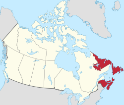
Atlantic Canada, also called the Atlantic provinces (French: provinces de l'Atlantique), is the region of Eastern Canada comprising four provinces: New Brunswick, Newfoundland and Labrador, Nova Scotia, and Prince Edward Island. As of 2021, the landmass of the four Atlantic provinces was approximately 488,000km2 (188,000sqmi), and had a population of over 2.4 million people. The term Atlantic Canada was popularized following the admission of Newfoundland as a Canadian province in 1949. The province of Newfoundland and Labrador is not included in the Maritimes, another significant regional term, but is included in Atlantic Canada.
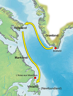
Leif Erikson and other members of his family began exploring the North American coast in 986 CE.[9][10] Leif landed in three places, and in the third established a small settlement called Vinland.[11][12] The location of Vinland is uncertain,[13] but an archaeological site on the northern tip of Newfoundland at L'Anse aux Meadows[14] has been identified as a good candidate.[15][16] It was a modest Viking settlement and is the oldest confirmed presence of Europeans in North America.[12][17] The Vikings would make brief excursions to North America for the next 200 years, though further attempts at colonization were thwarted.[12] The site produced the first evidence of pre-Columbian trans-oceanic contact of Europeans with the Americas outside of Greenland.[17][18]
Acadia, a colony of New France, was established in areas of present-day Atlantic Canada in 1604, under the leadership of Samuel de Champlain and Pierre Dugua, Sieur de Mons.[19] The French would form alliances with many indigenous groups within Atlantic Canada, including the Mi'kmaq of Acadia, who joined the Wabanaki Confederacy, important allies to New France.[20]
British expansion
Painting shows romanticised view of United Empire Loyalists arriving in New Brunswick, ca. 1783
Competition for control of the island of Newfoundland and its waters contributed to major ongoing conflicts and occasional wars between France and Britain.[21] The first major agreement between the two powers over access to this coastline came with the Treaty of Utrecht of 1713,[22] giving Britain governance over the entire island and establishing the first French Shore,[23][24] giving France and its migratory fishery almost exclusive access to a substantial stretch of the island's coastline.[25][26]
Despite reoccurring wars and conflicts, Britain acquiesced to France's demands for continuing access to this fishery.[22] Between 1755 and 1764 during the Seven Years' War the British forcibly removed thousands of Acadians from Nova Scotia and New Brunswick in an event known as the Great Expulsion or Le Grand Dérangement.[26][27] Following the Seven Years War and the Treaty of Paris of 1763, Newfoundland's governor, Admiral Hugh Palliser, consolidated British control by carrying out the first systematic hydrographic charting of the island,[28] including the Bay of Islands and Humber Arm, much of it by the Royal Naval officer James Cook.[21][29][30]
After the signing of the Treaty of Paris in 1764 some of the Acadians returned and settled in the area that would become New Brunswick.[31] The effect of this migration can still be seen today as the province of New Brunswick is the only officially bilingual province in Canada with over a quarter of residents speaking French at home.[32][33][34]
Immigration: from loyalists to the Irish
Rose Fortune, daughter of Fortune a free Negro, who immigrated to Nova Scotia as a child after the American Revolution.
After the conclusion of the American Revolution with the signing of the Treaty of Paris in 1783 many loyalists from the United States settled in the region.[36][37] This influx of immigrants caused the partition of Nova Scotia creating New Brunswick.[38][39] Additionally these immigrants changed the culture and character of the region which had historically been French towards more British styled communities.[40][41] It also marked one of the first large waves of migration to the area that established a predominantly Anglo-Canadian population.[37][42][43] Some of the new settlers brought with them Black slaves.[44][45] Also 3,000 Black loyalists who were slaves during the war and who sided with the British were given freedom and evacuated with other Loyalists from New York to Nova Scotia.[46][47] Most of the free Blacks settled at Birchtown,[48] the most prominent Black township in North America at the time.[49][50]
The War of 1812 significantly impacted the provinces of Atlantic Canada where they played crucial roles in naval operations, privateering,[51] and as strategic support bases for the British war effort against the United States.[52]
In the last half of the 19th century the region's population grew due to the immigration from Ireland due to the great potato famine.[53][54]Saint John and Halifax, both port cities, particularly received a significant influx of Irish immigrants within the region,[55] with Saint John's quarantine station on Partridge Island being the second-busiest in British North America during the epidemic typhus outbreak.[56]
Atlantic Canada is characterized by its rugged coastlines, gravel beaches, rugged mountains, and dense forests.[63][31]
Region and nearby area
The area is bordered by the Atlantic Ocean to the east and south[64] and Quebec to the west.[65] The region shares two international borders one with the United States and its State of Maine[63] and another off the coast of Newfoundland with France and its overseas collectivity of Saint Pierre and Miquelon.[66][67] The region's maritime environment has influenced the region's climate, culture, and economy.[63][68] The area encompasses a mix of urban centers like Halifax and St. John's and rural communities that rely on fishing, and tourism.[63][69]
The Atlantic provinces contribute a large part of Canada's fish production,[91][92] with many coastal communities primarily dependent on fisheries.[93] Over half of all ocean related jobs in Canada are found in Atlantic Canada with 75% of the ocean economy centered in its provinces.[94] The access point for many of such fisheries being the Gulf of St. Lawrence[95] and the Atlantic continental shelf.[96][97] Due to the collapse of the Atlantic northwest cod fishery Canada imposed a moratorium of cod fishing in 1992.[98][99] This affected the region significantly and caused the loss of between 30,000 and 50,000 jobs in the region which was the largest single layoff in Canadian history.[100][101] The Atlantic Canada Opportunities Agency is the official agency responsible for creating economic opportunities within Atlantic Canada.[102][103]
Power production
Labrador hosts the second largest hydroelectric system in Canada at Churchill Falls where it produces 35,000 GWh of power each year.[104][105] Elsewhere in the region wind power and hydrogen generation have begun to make a large impact on the energy landscape including exporting energy to Canada and hydrogen overseas.[106][107][108]
12White, Graham (2023). "We are in charge here": Inuit self-government and the Nunatsiavut Assembly. Toronto Buffalo: University of Toronto Press. ISBN978-1-4875-5274-9.
↑Natcher, David C.; Felt, Larry; Procter, Andrea H., eds. (2012). Settlement, subsistence, and change among the Labrador Inuit: the Nunatsiavummiut experience. Contemporary studies on the North. Winnipeg: Univ. of Manitoba Press. ISBN978-0-88755-419-3.
↑Wallace-Murphy, Tim; Martin, James (2023). Uncharted: a rediscovered history of voyages to the Americas before Columbus. Newburyport, MA: New Page. ISBN978-1-63748-011-3.
↑Seaver, Kirsten A. (2000). The frozen echo: Greenland and the exploration of North America, c. A.D. 1000 - 1500. Stanford, Calif.: Stanford Univ. Press. ISBN978-0-8047-3161-4.
↑Walker, James W. St G. (1999). The Black Loyalists: the search for a promised land in Nova Scotia and Sierra Leone; 1783 - 1870 (Repred.). Toronto: Univ. of Toronto Press. ISBN978-0-8020-7402-7.
↑Stranack, Ian (1990). The Andrew and the Onions: the story of the Royal Navy in Bermuda, 1795-1975 (2nded.). Old Royal Navy Dockyard, Bermuda: Bermuda Maritime Museum Press. ISBN978-0-921560-03-6.
↑Willeen, Keough (2008). The Slender Thread: Irish Women on the Southern Avalon. Columbia University Press.
↑Power, Thomas P., ed. (1991). The Irish in Atlantic Canada: 1780-1900. Fredericton: New Ireland Press. ISBN978-0-920483-18-3.
1234567Bone, Robert M. (2008). "Atlantic Canada". The regional geography of Canada (4thed.). Don Mills, Ont.; New York: Oxford University Press. ISBN978-0-19-542536-9.
↑Tremblay, Rémy; Chicoine, Hugues, eds. (2013). The geographies of Canada. "Canadian studies" series. Bruxelles: P.I.E Peter Lang. ISBN978-2-87574-017-5.
↑Fullerton, Laurie (1993). Vacations in the Maritimes: a tourbook of Nova Scotia, Prince Edward Island, New Brunswick plus Newfoundland and Labrador. A Yankee Books travel guide. Dublin, N. H.: New York: Yankee Books; Distributed in the book trade by St. Martin's Press. ISBN978-0-89909-356-7.
This page is based on this Wikipedia article Text is available under the CC BY-SA 4.0 license; additional terms may apply. Images, videos and audio are available under their respective licenses.