Bay of Islands, Newfoundland and Labrador

Last updated
Bay of Islands
Curling, Bay of Islands.jpg
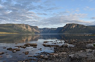
The Humber Arm of the Bay of Islands
Canada Newfoundland relief location map.jpg
Red pog.svg
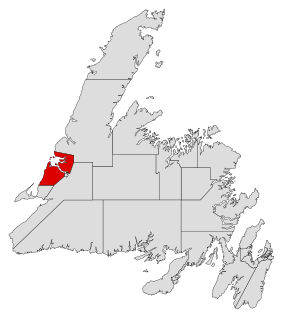
Bay of Islands
Location of the Bay of Islands in Newfoundland
Location Newfoundland and Labrador
Coordinates 49°09′57″N58°15′51″W / 49.16583°N 58.26417°W / 49.16583; -58.26417 Coordinates: 49°09′57″N58°15′51″W / 49.16583°N 58.26417°W / 49.16583; -58.26417
Native nameElmastukwek  (Mi'kmaq)
River sources Humber River
Ocean/sea sources Gulf of St. Lawrence, North Atlantic Ocean
Basin  countries Canada
Islands Eagle Island, French Island, Governors Island, Green Island, Guernsey Island, Hen Island, Outer Shag Rock, Puffin Island, Seal Island, Shag Rocks, Sleep Island, The Hat, Tweed Island, Pearl Island, & Woods Island (largest),

The Bay of Islands is an extensive inlet located on the west coast of the island of Newfoundland, in Canada. [1] The Way Office was established on July 1, 1883. The first Waymaster was Thomas Carter. The largest island in the bay is Woods Island (which was formerly inhabited). It is surrounded in most directions by the Long Range Mountains and it is directly north of the Lewis Hills.

It is also a sub-basin of the Gulf of St. Lawrence. The bay consists of many inlets such as Humber Arm and Goose Arm.

Flowing into the Bay of Islands is the Humber River. Draining Deer Lake, the Humber is one of the major rivers on the island of Newfoundland, making the Bay of Islands an important estuary. Near the mouth of the Humber River, appropriately named "Humber Mouth", is the city of Corner Brook (2011 pop.: 19,886), as well as several neighboring suburbs. The Humber River was used for many years to float logs down to the Bay of Islands where a large Bowater pulp and paper mill at Corner Brook turned them into paper products. Today this mill is owned by Kruger Inc and its logs are transported by truck. Although the river is mainly used for recreational purposes, the bay still sees active shipping to and from Corner Brook's port.

Other towns along the shores of the Bay of Islands are mostly dependent upon the fishing industry. These communities include (on the southern shore of Humber Arm, the southernmost bay) Mt Moriah, Humber Arm South, Lark Harbour, and York Harbour, (on the northern shore of Humber Arm) Hughes Brook, Irishtown-Summerside, Meadows, Gillams, McIvers, and (on Middle Arm, north of Humber Arm) Cox's Cove. There are still fish plants in Cox's Cove, Humber Arm South and Curling. Curling was once an incorporated community but is now amalgamated with Corner Brook.

The Bay of Islands are bordered on the north and south by North Arm Hills and Blow Me Down mountains, which are part of the Humber Arm Allochthon, which also include the Lewis Hills and the Tablelands.

See also

Related Research Articles

Gros Morne National Park National Park on the west coast of Newfoundland

Gros Morne National Park is a Canadian national park and World Heritage Site located on the west coast of Newfoundland. At 1,805 km2 (697 sq mi), it is the second largest national park in Atlantic Canada after Torngat Mountains National Park, which has an area of 9,700 km2 (3,700 sq mi).

Clarenville is a town on the east coast of Newfoundland in the province of Newfoundland and Labrador, Canada. Clarenville was incorporated in 1951. It is located in the Shoal Harbour valley, fronting an arm of the Atlantic Ocean called Random Sound.

Corner Brook City in Newfoundland and Labrador, Canada

Corner Brook is a city located on the west coast of the island of Newfoundland in the province of Newfoundland and Labrador, Canada. Corner Brook is the fifth largest settlement in Newfoundland and Labrador.

Stephenville, Newfoundland and Labrador Town in Newfoundland and Labrador, Canada

Stephenville is a town in Newfoundland and Labrador, Canada, on the west coast of the island of Newfoundland.

Humber-Bay of Islands

Humber-Bay of Islands is a provincial electoral district for the House of Assembly of Newfoundland and Labrador, Canada. As of 2015, the district has 13,412 eligible voters.

Humber East

Humber East is a former provincial electoral district for the House of Assembly of Newfoundland and Labrador, Canada.

Baie Verte-Green Bay

Baie Verte-Green Bay is a provincial electoral district for the House of Assembly of Newfoundland and Labrador, Canada. As of 2011 it has 8,067 eligible voters. The district was redistributed in 2015.

Area code 709 Telephone area code for Newfoundland and Labrador

Area code 709 is the telephone area code in the North American Numbering Plan (NANP) for the entire Canadian province of Newfoundland and Labrador.

Curling, Newfoundland and Labrador Neighbourhood in Corner Brook, Newfoundland and Labrador, Canada

Curling is a mainly residential neighbourhood of the city of Corner Brook, Newfoundland and Labrador. It is situated just west of the main part of the city. Located in the Humber Arm of the Bay of Islands, Curling was originally a fishing community. It is the oldest section of Corner Brook.

Humber Arm

The Humber Arm is the southernmost arm of the Bay of Islands on the west coast of Newfoundland. The arm has the highest concentration of fresh water of the entire bay, due to inflow of the Humber River.

Springdale, Newfoundland and Labrador Town in Newfoundland and Labrador, Canada

Springdale is a town in Newfoundland and Labrador, Canada, which had a population of 2,971 people in 2016, up from 2,764 in the Canada 2006 Census. The community is located on the Northwestern shores of Hall's Bay in Central Newfoundland, near the mouth of Indian River.

The Humber Valley is a region in the western part of the island of Newfoundland. The Humber Valley is formed by the Humber River.

Division No. 5, Newfoundland and Labrador Census division in Newfoundland and Labrador, Canada

Census Division No. 5 is a Statistics Canada statistical division composed of the areas of the province of Newfoundland and Labrador called Humber Valley, Bay of Islands, and White Bay. It covers a land area of 10,365.63 km², and had a population of 42,014 according to the 2016 census.

Hampden, Newfoundland and Labrador Town in Newfoundland and Labrador, Canada

Hampden is a town in the Canadian province of Newfoundland and Labrador. The town has a population of 429. Two islands can be seen from the shore of Hampden, Granby Island and Millers Island. The latter is much closer to the town and is the host of a tuberculosis grave-site.

Bottle Cove Fishing Village in Newfoundland and Labrador, Canada

Bottle Cove is located on the west coast of Newfoundland. It opens directly onto the Gulf of Saint Lawrence, although it is typically included in the regional descriptor, "Bay of Islands," which lies at the mouth of the Humber Arm. Bottle Cove is also referred to as Bottle Cove Provincial Park and as Bottle Cove Day Park in official Parks documentation.

Sops Arm

Sop's Arm is a local service district and designated place in the Canadian province of Newfoundland and Labrador. The community was formed in the 1930s and 1940s by families moving from surrounding communities, including Jackson's Arm. In the 1950s and 1960s families from nearby Sop's Island moved to Sop's Arm, towing their houses across the channel of water.

Route 450 is a highway in the Canadian province of Newfoundland and Labrador. The highway starts at an interchange at Route 1 in Corner Brook. When approaching O'Connell Drive, motorists can turn left to continue their journey along the route. The route terminates at a cul-de-sac in Lark Harbour.

Route 440 is a relatively short highway in the Canadian province of Newfoundland and Labrador, on the West Coast. The highway was named in honor of Admiral Hugh Palliser. The highway starts at an interchange at Route 1 in Corner Brook, and terminates at Cox's Cove. The speed limit is 80 km/h except in communities where the speed is reduced to 50 km/h.

Woods Island, Newfoundland and Labrador Abandoned Town in Newfoundland and Labrador, Canada

Woods Island is an abandoned island town in Newfoundland and Labrador.

References

  1. United States Hydrographic Office; Davenport, Richard G. (1884). Newfoundland and Labrador: The coast and banks of Newfoundland and the coast of Labrador, from Grand Point to the Koksoak River, with the adjacent islands and banks (Public domain ed.). Govt. print. off. pp. 195–. Retrieved 20 November 2011.