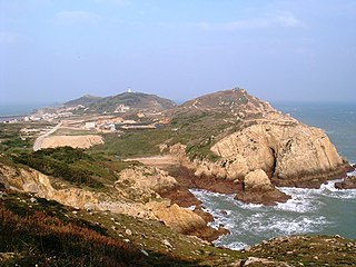
Juguang Township / Jyuguang Township, also spelled Chukuang, is a rural township of Lienchiang County, Republic of China (Taiwan). Juguang Township includes two major islands, Dongju Island and Xiju Island, as well as some islets.
The Senkaku Islands are a group of uninhabited islands in the East China Sea, administered by Japan. They are located northeast of Taiwan, east of China, west of Okinawa Island, and north of the southwestern end of the Ryukyu Islands. They are known in mainland China as the Diaoyu Islands or Diaoyu Dao and its affiliated islands, in Taiwan as the Diaoyutai Islands or Tiaoyutai Islands, and sometimes in the Western world by the historical name Pinnacle Islands. In Okinawan they are called ʔiyukubajima (魚蒲葵島). In Yaeyama dialect, they are called iigunkubajima.

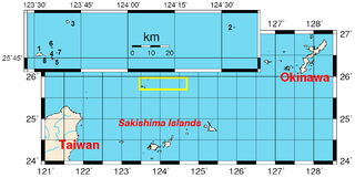
The Sakishima Islands are an archipelago located at the southernmost end of the Japanese Archipelago. They are part of the Ryukyu Islands and include the Miyako Islands and the Yaeyama Islands. The islands are administered as part of Okinawa Prefecture, Japan.

Gusuku often refers to castles or fortresses in the Ryukyu Islands that feature stone walls. However, the origin and essence of gusuku remain controversial. In the archaeology of Okinawa Prefecture, the Gusuku period refers to an archaeological epoch of the Okinawa Islands that follows the shell-mound period and precedes the Sanzan period, when most gusuku are thought to have been built. Many gusuku and related cultural remains on Okinawa Island have been listed by UNESCO as World Heritage Sites under the title Gusuku Sites and Related Properties of the Kingdom of Ryukyu.
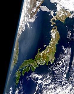
The Japanese archipelago is a group of 6,852 islands that form the country of Japan. It extends over 3,000 km (1,900 mi) from the Sea of Okhotsk in the northwest to the East China and Philippine Seas in the southwest along the Pacific Ocean coast of the Eurasian continent, and consists of three island arcs from north to south: the Northeastern and Southwestern Japan Arcs, and the Ryukyu Island Arc. The Kuril Island Arc, the Daitō Islands, and the Nanpō Islands are not parts of the archipelago.
Amami Ōshima, also known as Amami, is the largest island in the Amami archipelago between Kyūshū and Okinawa. It is one of the Satsunan Islands.

The Yaeyama Islands are an archipelago in the southwest of Okinawa Prefecture, Japan, and cover 591.46 square kilometres (228.36 sq mi). The islands are located southwest of the Miyako Islands, part of the Ryukyu Islands archipelago. The Yaeyama Islands are the remotest part of Japan from the main islands and contain Japan's most southern (Hateruma) and most western (Yonaguni) inhabited islands. The city of Ishigaki serves as the political, cultural, and economic center of the Yaeyama Islands.

Okinotorishima, or Parece Vela, is a coral reef with two rocks enlarged with tetrapod-cement structures. It is administered by Japan with a total shoal area of 8,482 m2 and land area 9.44 square metres (101.6 sq ft). Its dry land area is mostly made up by three concrete encasings and there is a 100 by 50 m stilt platform in the lagoon housing a research station. There is a third completely artificial tetrapod-cement islet. It is located on the Palau–Kyushu Ridge in the Philippine Sea, 534 km (332 mi) southeast of Okidaitōjima and 567 km (352 mi) west-southwest of South Iwo Jima in the Bonin Islands or 1,740 km (1,080 mi) south of Tokyo, Japan. The atoll is the southernmost part of Japan and the only Japanese territory south of the Tropic of Cancer.

The Ryukyu Islands are, depending on definitions, the whole or part of a chain of Japanese islands that stretch southwest from Kyushu to Taiwan. According to the standardized geographical names of Japan, the Nansei Islands cover the entire island chain: the Ōsumi, Tokara, Amami, Okinawa, Sakishima Islands, the Senkaku Islands, and the Daitō Islands, with Yonaguni the westernmost. According to the standard, the Ryūkyū Shotō consist of the Okinawa, Sakishima and Senkaku Islands. A related term, the Ryukyu Arc, often excludes the outlying islands of Senkakus and Daitōs. The larger are mostly high islands and the smaller mostly coral. The largest is Okinawa Island.

Kikaijima is one of the Satsunan Islands, classed with the Amami archipelago between Kyūshū and Okinawa.

The Satsunan Islands is a geopolitical name for a group of islands that forms the northern part of the Ryukyu Islands. The whole island group belongs to Kagoshima Prefecture, Japan.

Wuqiu is a group of islands comprising two major islands, namely Greater Qiu Islet and Smaller Qiu Islet, in the Taiwan Strait. Administratively, Wuqiu Township is a rural township which is part of Kinmen County (Quemoy) of the Republic of China (Taiwan). It is the smallest township in Kinmen County and is located 72 nmi (133 km) northeast of the rest of the county. The township is 73 nmi (135 km) from the Port of Taichung on Taiwan. The closest territory under PRC control is the neighboring Luci Island, Xiuyu District, Putian, Fujian, which is 9 nmi (17 km) to the north-northwest. Greater Qiu Island is the site of the Wuqiu Lighthouse.
A map of Japan currently stored at Kanazawa Bunko depicts Japan and surrounding countries, both real and imaginary. The date of creation is unknown but probably falls within the Kamakura period. It is one of the oldest surviving Gyōki-type maps of Japan. It reveals Japan's self-image and the understanding of neighboring countries after the Mongol invasions of 1274 and 1281
Dongding Island is an 0.0160 square kilometer island in the Taiwan Strait in Jinhu Township, Kinmen County (Quemoy), Fujian Province, Republic of China (Taiwan). The island is the southernmost point of Kinmen County. The island is near Longhai City, Zhangzhou, Fujian, China.
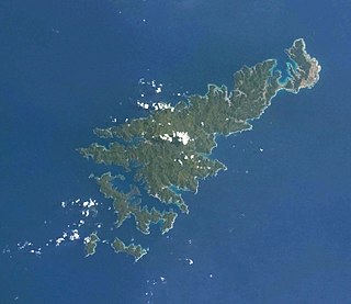
Okinawa (沖縄) is a name with multiple referents. The endonym prototypically refers to Okinawa Island in southwestern Japan. Today it can cover some surrounding islands and, more importantly, can refer to Okinawa Prefecture, a much larger administrative division of Japan, although the people from the Miyako and Yaeyama Islands still feel a strong sense of otherness to Okinawa.

The Aragusuku Islands consist of two smaller islets, named Kamiji and Shimoji. They are located in the Yaeyama Islands of Okinawa Prefecture, Japan.

Amami-Ōshima Island, Tokunoshima Island, northern part of Okinawa Island, and Iriomote Island (奄美大島、徳之島、沖縄島北部及び西表島) is a serial UNESCO World Heritage Site consisting of five component parts on four Japanese islands in the Ryukyu Chain of the Nansei Islands. The site was selected in terms of biodiversity for having a diverse ecosystem of plant and animal species that are unique to the region.
