

The following outline is provided as an overview of and topical guide to Nova Scotia:
Contents
- General reference
- Geography of Nova Scotia
- Environment of Nova Scotia
- Regions of Nova Scotia
- Demographics of Nova Scotia
- Government and politics of Nova Scotia
- Federal representation
- Provincial government of Nova Scotia
- Law and order in Nova Scotia
- Military in Nova Scotia
- History of Nova Scotia
- History of Nova Scotia, by period
- History of Nova Scotia, by region
- History of Nova Scotia, by subject
- Culture of Nova Scotia
- Heritage sites in Nova Scotia
- The Arts in Nova Scotia
- Sports in Nova Scotia
- Economy and infrastructure of Nova Scotia
- Education in Nova Scotia
- See also
- References
- External links
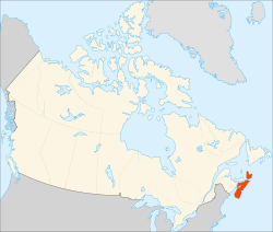
Nova Scotia – meaning New Scotland in Latin, is the second-smallest province in Canada. [1] It is one of Canada's three Maritime provinces, with its mainland territory consisting of the Nova Scotia peninsula surrounded by the Atlantic Ocean, in addition to over 3,800 coastal islands, the largest one being Cape Breton Island.