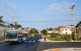
Mainland Halifax

Last updated
Mainland Halifax
Novascotiahrm-halifaxmainland.png
Location of Mainland Halifax in Halifax Regional Municipality
Canada Nova Scotia location map 2.svg
Red pog.svg
Mainland Halifax
Location of Mainland Halifax in Nova Scotia
Coordinates: 44°37′45.9″N63°36′19.5″W / 44.629417°N 63.605417°W / 44.629417; -63.605417 Coordinates: 44°37′45.9″N63°36′19.5″W / 44.629417°N 63.605417°W / 44.629417; -63.605417
CountryFlag of Canada (Pantone).svg  Canada
ProvinceFlag of Nova Scotia.svg  Nova Scotia
Municipality Halifax Regional Municipality
Founded1996
Communities and neighbourhoods Armdale, Bayers Lake, Boulderwood, Bridgeview, Clayton Park, Clayton Park West, Cowie Hill, Fairmount, Fairview, Green Acres, Leiblin Park, Melville Cove, Rockingham, Purcell's Cove, Sherwood Heights, Spryfield, Wedgewood, Williams Lake
Government
  Type Municipal council
Area
  Land43.012 km2 (16.607 sq mi)
Population
 (2021) [3] [4]
  Total83,972
  Density1,952/km2 (5,060/sq mi)
Time zone UTC-4 (AST)
Area code(s) 782, 902
Places in Nova Scotia

Mainland Halifax is the remaining portion of the community of Halifax, without the Halifax Peninsula.

Contents

History

For thousands of years, and currently, Mainland Halifax has been, is, and will be on the unceded ancestral lands of the Mi'kmaq.

On 21 June 1749, the Town of Halifax was founded. Europeans began to colonize the area, and sometime between 1841-and-1842, Halifax was granted city status. Between 1841 and 1842—and—1969, Halifax expanded to become the entire Halifax Peninsula.

In 1969, Halifax annexed several communities from Halifax County, and they were located in what would become the area of Mainland Halifax; Armdale, Clayton Park, Fairview, Rockingham, Purcell's Cove and Spryfield.

On 1 April 1996, The City of Dartmouth, the City of Halifax, the County of Halifax, and the Town of Bedford amalgamated, and created the Halifax Regional Municipality. Subsequently, the entirety of the former City of Halifax was reestablished as the Community of Halifax and is coterminous with the former City itself. However, the new community was divided into two subsections; Mainland Halifax and Peninsular Halifax.

Currently, Mainland Halifax enjoys increased cultural, demographic, and economic growth from its great location. It hosts busy communities that make this a fantastic area within the municipality.

Geography

Mainland Halifax is portioned into two sections, Mainland North and Mainland South, divided by St. Margaret's Bay Road. The area of Mainland Halifax has a landmass of 4,301.2 hectares (43.012 km2).

Communities and neighbourhoods

Mainland North

Mainland South

Topography

The area lies west of the Bedford Basin and Northwest Arm and extends several kilometres inland.

Demographics

Mainland Halifax's population as of 2021 was 83,972 people, an increase of 10,662 people (over 14.5%) from 73,310 people in 2016.

The area's population density increased by 248 people per km2, from approximately 1,704 people per km2 in 2016 to approximately 1,952 people per km2 in 2021.

Census TractLand area (km2)Population (2021) [5] Population (2016) [6] Population Density (people per km2) (2021)Population Change (%)
2050001.005.7034,1233,868722Increase2.svg6.5
2050002.0011.5188,3586,194725Increase2.svg34.9
2050014.001.8384,3904,2482,388Increase2.svg3.3
2050015.002.0425,3894,8292,639Increase2.svg15.9
2050016.002.5634,0213,7661,568Increase2.svg6.7
2050017.002.9122,9992,9141,029Increase2.svg2.9
2050024.002.1818,6187,3753,951Increase2.svg16.8
2050025.011.055,2014,7264,953Increase2.svg10
2050025.021.9135,5154,8632,882Increase2.svg13.4
2050025.040.9114,8184,6855,288Increase2.svg2.8
2050025.051.5563,7463,5472,407Increase2.svg5.6
2050026.021.5094,8553,4093,217Increase2.svg42.4
2050026.031.3933,3483,3582,403Decrease2.svg0.3
2050026.040.6544,3464,1996,645Increase2.svg3.5
2050026.050.7713,8663,9675,014Decrease2.svg2.5
2050027.004.49810,3797,3622,307Increase2.svg40.9
Mainland Halifax43.01283,97273,3101,952Increase2.svg14.5
Mainland Halifax historic population
YearPop.±%
2016 73,310    
2021 83,972+14.5%

Related Research Articles

<span class="mw-page-title-main">Dartmouth, Nova Scotia</span> Place in Nova Scotia, Canada

Dartmouth is an urban community and former city located in the Halifax Regional Municipality of Nova Scotia, Canada. Dartmouth is located on the eastern shore of Halifax Harbour. Dartmouth has been nicknamed the City of Lakes, after the large number of lakes located within its boundaries.

<span class="mw-page-title-main">Halifax (electoral district)</span> Federal electoral district in Nova Scotia, Canada

Halifax is a federal electoral district in Nova Scotia, Canada. It is one of a handful of ridings which has been represented continuously in the House of Commons since Confederation in 1867.
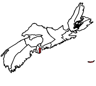
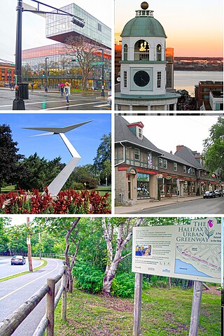
<span class="mw-page-title-main">Halifax, Nova Scotia</span> Capital and most populous municipality of Nova Scotia, Canada

Halifax is the capital and largest municipality of the Canadian province of Nova Scotia, and the largest municipality in Atlantic Canada. Halifax is one of Canada's fastest growing municipalities, and as of 2022, it is estimated that the CMA population of Halifax was 480,582, with 348,634 people in its urban area. The regional municipality consists of four former municipalities that were amalgamated in 1996: Halifax, Dartmouth, Bedford, and Halifax County.

Hammonds Plains is a community within the urban area of Municipality of Halifax, in Nova Scotia, Canada.

Spryfield is community within the urban area of Halifax, Nova Scotia, Canada.

<span class="mw-page-title-main">Halifax Peninsula</span> Place in Nova Scotia, Canada

The Halifax Peninsula is peninsula within the urban area of the Municipality of Halifax, Nova Scotia.

<span class="mw-page-title-main">South End, Halifax</span> Neighbourhood in Halifax, Nova Scotia, Canada

The South End is a neighbourhood within Halifax's urban area, in the Municipality of Halifax, Nova Scotia, Canada.

Armdale is a neighbourhood of the community of Halifax, Nova Scotia, Canada.

<span class="mw-page-title-main">Clayton Park, Nova Scotia</span> Community in Nova Scotia, Canada

Clayton Park is a community within Halifax, Nova Scotia, Canada.

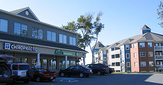
Rockingham is a community located within the urban area of the Municipality of Halifax, in Nova Scotia, Canada.

The Halifax Regional Municipality (HRM) in Nova Scotia, Canada has a widely varied geography.

<span class="mw-page-title-main">History of Halifax, Nova Scotia</span> Aspect of history

The community of Halifax, Nova Scotia was created on 1 April 1996, when the City of Dartmouth, the City of Halifax, the Town of Bedford, and the County of Halifax amalgamated and formed the Halifax Regional Municipality. The former City of Halifax was dissolved, and transformed into the Community of Halifax within the municipality.

Timberlea is a community located within the Municipality of Halifax in Nova Scotia, Canada.

Fergusons Cove is a suburban community within the Halifax Regional Municipality (HRM), Nova Scotia on the western shore of Halifax Harbour between Purcell's Cove and Herring Cove along Route 253. The first 3 digits of the postal code in the area are B3V.

<span class="mw-page-title-main">Fairview, Nova Scotia</span> Urban Community in Nova Scotia, Canada

Fairview is a community within the urban area of Halifax in Nova Scotia, Canada.

<span class="mw-page-title-main">Communities in the Halifax Regional Municipality</span>

The Halifax Regional Municipality (HRM) in the Canadian province of Nova Scotia is composed of more than 200 communities and neighbourhoods. As of the 2021 Census, the municipality has a landmass of 547,557 hectares and is home to 439,819 people.

<span class="mw-page-title-main">Cowie Hill</span> Community in Nova Scotia, Canada

Cowie Hill is a community within the urban area of the Municipality of Halifax, in Nova Scotia, Canada.

<span class="mw-page-title-main">Timeline of Halifax, Nova Scotia history</span>

This timeline of the History of the Halifax Regional Municipality documents all events that had happened in Halifax, Nova Scotia, Canada, including historical events in the former city of Dartmouth, the Town of Bedford and Halifax County. Events date back to the early-18th century and continue until the present in chronological order.

Herring Cove is a Canadian suburban and former fishing community in Nova Scotia's Halifax Regional Municipality. It is situated on the eastern shore of the Chebucto Peninsula, 15 km (9.3 mi) south of Downtown Halifax. It is near the western approaches to Halifax Harbour, and can be reached both via Purcell's Cove along the coastal road and from inland via the Herring Cove Road through Spryfield. There are two schools in Herring Cove, William King Elementary and Herring Cove Junior High. The community is also home to a small variety of small businesses and programs.

<span class="mw-page-title-main">Amalgamation of the Halifax Regional Municipality</span>

The amalgamation of four municipalities on April 1, 1996, was the creation of the Halifax Regional Municipality, Nova Scotia, Canada. It resulted in the regional municipality's current boundaries.
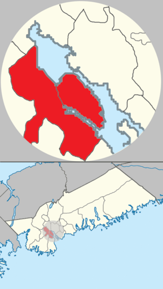
References

  1. "Census 2021 Census Tracts". HRM Open Data. Government of the Municipality of Halifax. Retrieved 10 August 2022.
  2. "Census 2016 Census Tracts". HRM Open Data. Government of the Municipality of Halifax. Retrieved 10 August 2022.
  3. "Census 2021 Census Tracts". HRM Open Data. Government of the Municipality of Halifax. Retrieved 10 August 2022.
  4. "Census 2016 Census Tracts". HRM Open Data. Government of the Municipality of Halifax. Retrieved 10 August 2022.
  5. "Census 2021 Census Tracts". HRM Open Data. Government of the Municipality of Halifax. Retrieved 10 August 2022.
  6. "Census 2016 Census Tracts". HRM Open Data. Government of the Municipality of Halifax. Retrieved 10 August 2022.