
Mount Olivet Cemetery is a Roman Catholic cemetery located in Halifax, Nova Scotia, Canada at which 19 bodies recovered from the RMS Titanic are buried.

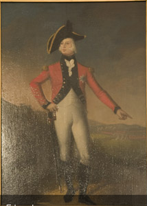
Spryfield is an unincorporated suburban community in Halifax, Nova Scotia, Canada. It was founded about 1770, by Captain William Spry, who purchased land there and established the settlement with the aid of stationed soldiers from the nearby Halifax garrison. In 1783, he sold the property and returned to England. The name "Spryfield" is also sometimes used to refer to the general area of Halifax's South Mainland, which includes a number of communities along the Herring Cove and Purcell's Cove Roads.

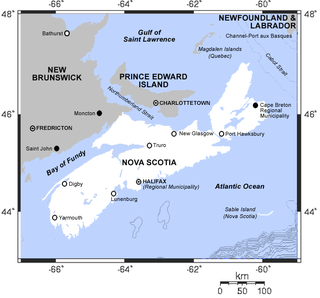
The Chebucto Peninsula is a Canadian peninsula located in central Nova Scotia entirely within the Halifax Regional Municipality on the Atlantic coast.

The Hydrostone is a neighbourhood in the North End of the Halifax Peninsula in the Halifax Regional Municipality, Nova Scotia, Canada. It consists of ten short parallel streets and is bordered by Duffus Street to the north, Young Street to the south, Isleville Street to the west and Novalea Drive to the east.
Richmond was a Canadian urban neighbourhood comprising part of the North End of the Halifax Peninsula in Nova Scotia's Halifax Regional Municipality.
Route 318 is a collector road in the Canadian province of Nova Scotia.

The Halifax Court House is a historic building in downtown Halifax, Nova Scotia. Its main section was completed in 1863, with the east wing, built in 1930, being the newest portion. The Italian renaissance style building was designed by William Thomas, a Toronto architect who built prominent structures across Canada.
Prince's Lodge is a Subdivision located on the shore of Bedford Basin between the communities of Rockingham and Bedford in the Halifax Regional Municipality Nova Scotia on the Bedford Highway.
Burnside Drive is a four-lane divided roadway, with a speed limit of 80 km/h, that serves the Burnside Business Park in the Halifax Regional Municipality (HRM) community of Dartmouth, Nova Scotia. The road parallels Highway 118, running north from exit 3 of Highway 111 to Akerley Boulevard, a western extension of Highway 107. Although some maps produced by the province show Burnside Drive, as well as a portion of Akerley Boulevard, as part of Highway 107, these roads are actually maintained by the HRM, and Highway 107 becomes Akerley Boulevard about halfway between Highway 118 and Burnside Drive.
Wellington located at 44°51'54"N, 63°36'59"W is a residential community of the Halifax Regional Municipality, Nova Scotia on Fletcher's Lake on Trunk 2 approximately 23.3 kilometres (14.5 mi) from Halifax.

Robie Street is a north-south artery, street and provincial road that runs for 7 kilometres within the Halifax Peninsula area of the Halifax Regional Municipality, from Memorial Drive in the North End Halifax, to Gorsebrook Avenue in the South End. The street in most places is 4 lanes wide with a centre median from Gorsebrook Ave to Cunard Street. From Cunard to Almon Streets, it is a 2-lane street.
Halifax was a provincial electoral district in Nova Scotia, Canada, that elected three, and then five members to the Nova Scotia House of Assembly. It existed from 1867 to 1933, at which point Halifax County was divided into five separate electoral districts: Halifax South, Halifax Centre, Halifax North, Halifax East and Halifax West.

The Halifax Farmers' Market is the oldest continuously operating farmer's market in North America having been founded in 1750. Over the years the market has been held in many locations around Halifax, Nova Scotia, including Keith's Brewery Building on 1496 Lower Water Street.
Pockwock is one of four Black Nova Scotian settlements in Upper Hammonds Plains. People in this area are mostly descendants of War of 1812 refugees. It is located in the Halifax Regional Municipality in the Canadian province of Nova Scotia. The Halifax Regional Water Commission uses Pockwock Lake as a source for water for the communities of Halifax, Bedford and Lower Sackville.
Sunset Acres is a neighborhood of Westphal, Nova Scotia, Canada, in the Halifax Regional Municipality.
There are various Black Lakes in Nova Scotia, Canada. They vary widely in size, depth and usability. Many counties, such as Cumberland, Halifax, Inverness, and Pictou Counties have more than one Black Lake so named, while other counties mentioned in this article have only one named Black Lake.

The Halifax School for the Deaf was an institution in Halifax, Nova Scotia that opened on August the 4th, 1856. It was the first school of the deaf in Atlantic Canada. There was later a dispute over who the true founder was, William Gray (1806-1881), a deaf Scottish immigrant who was the first teacher in the back room of a house in Argyle Street, or George Tait (1828-1904), another deaf Scot, who claimed to have been the driving force behind the establishment of the school. Gray was sacked in 1870 for being intoxicated and for threatening pupils with violence.

The Nova Scotia Museum of Natural History, part of the Nova Scotia Museum, is located in downtown Halifax, Nova Scotia. The museum includes collections and exhibits concerning the natural sciences as well as artifacts of cultural significance to Nova Scotia.

The Black-Binney House was a former residence built in 1819 in Halifax, Nova Scotia which is now a National Historic Site of Canada. The house was built by John Black (merchant) and is reflective of the Palladian-inspired residences common during the late 18th and early 19th centuries in Eastern Canada. In 1857, Hibbert Binney subdivided the property to build the St. Matthew's United Church (Halifax). In 1965 Sidney Culverwell Oland purchased and renovated the building to house the Nova Scotia Division of the Canadian Corps of Commissionaires.

A township in Nova Scotia, Canada, was an early form of land division and local administration during British colonial settlement in the 18th century. They were typically rural or wilderness areas of around 100,000 acres (400 km2) that would eventually include several villages or towns. Some townships, but not all, returned a member to the General Assembly of Nova Scotia; others were represented by the members from the county. Townships have been made obsolete by various Acts of the Nova Scotia legislature.


