Annapolis Valley

Last updated

Annapolis Valley
Annapolis valley map.png
The Annapolis Valley region as defined by Statistics Canada
CountryCanada
ProvinceFlag of Nova Scotia.svg  Nova Scotia
Counties Annapolis County
Kings County
Hants County
Area
  Land8,367.78 km2 (3,230.82 sq mi)
Population
 (2021) [1]
  Total129,306
  Density15.5/km2 (40/sq mi)
  Change 2016–21
Increase2.svg4.5%
Time zone UTC-4 (AST)
  Summer (DST) UTC-3 (ADT)
Area code 902
Dwellings62,284

The Annapolis Valley is a valley and region in the province of Nova Scotia, Canada. It is located in the western part of the Nova Scotia peninsula, formed by a trough between two parallel mountain ranges along the shore of the Bay of Fundy. Statistics Canada defines the Annapolis Valley as an economic region, composed of Annapolis County, Kings County, and Hants County.

Contents

Geography

The valley measures approximately 126 kilometres (78 mi) in length from Digby and the Annapolis Basin in the west to Wolfville and the Minas Basin in the east, spanning the counties of Digby, Annapolis and Kings.

Some also include the western part of Hants County, including the towns of Hantsport and Windsor even further to the east, but geographically speaking they are part of the Avon River valley.

The steep face of basaltic North Mountain shelters the valley from the adjacent Bay of Fundy and rises over 260 metres (850 ft) in elevation near Lawrencetown. [2] The granitic South Mountain rises to a somewhat higher elevation and shelters the valley from the climate of the Atlantic Ocean approximately 100 kilometres further south on the province's South Shore.

The shelter provided by these two mountainous ridges has produced a microclimate which provides relatively mild temperatures for the region and, coupled with the fertile glacial sedimentary soils on the valley floor, the region is conducive to growing vegetable and fruit crops. [3] Particularly famous for its apple crop, the valley hosts in excess of 1,000 farms of various types, the majority being relatively small family-owned operations.

Within the valley itself are two major rivers, the Annapolis River which flows west from Caribou Bog in the central part of the valley into Annapolis Basin, and the Cornwallis River which flows east from Caribou Bog into Minas Basin. The North Mountain ridge forms the north side of the Annapolis Valley. Also flowing east, in two smaller valleys north of the Cornwallis River, are the Canard River and the Habitant River, both of which also flow into the Minas Basin.

History

Annapolis Valley from North Mountain in Valleyview Provincial Park, north of Bridgetown Annapolis Valley from lookoff1.JPG
Annapolis Valley from North Mountain in Valleyview Provincial Park, north of Bridgetown
Eastern End, with the Minas Basin to the right Road to Blomidon Provincial Park.jpg
Eastern End, with the Minas Basin to the right
Eastern end looking southeast across Annapolis Valley from "The Lookoff", North Mountain The Lookoff, North Mountain, Nova Scotia, Canada.jpg
Eastern end looking southeast across Annapolis Valley from "The Lookoff", North Mountain

Long settled by the Mi'kmaq nation, the valley experienced French settlement at the Habitation at Port-Royal, near modern-day Annapolis Royal in the western part of the valley, beginning in 1605. From there, the Acadians spread throughout the Valley, in various communities, building dykes to claim the tidal lands along the Annapolis and Cornwallis Rivers. They continued throughout the Annapolis Valley until the British-ordered expulsion of Acadians in 1755 which is memorialized at Grand-Pré in the eastern part of the valley. New England Planters moved in to occupy the abandoned Acadian farming areas and the region also saw subsequent settlement by Loyalist refugees of the American Revolutionary War, as well as foreign Protestants. These were followed by significant numbers of freed Africans in the War of 1812, Irish immigrants in the mid-19th century and Dutch immigrants after World War II. Agriculture in the Annapolis valley boomed in the late 19th century with the arrival of the Windsor and Annapolis Railway, later the Dominion Atlantic Railway, which developed large export markets for Annapolis Valley apples.

The Annapolis Valley Regional Library was established in 1949. It was the first regional library system in Nova Scotia. [4]

Economy

Central Valley, looking west southwest across farms in Clarence Clarence, Annapolis Valley, Nova Scotia.jpg
Central Valley, looking west southwest across farms in Clarence
Western Valley, overlooking narrowest part of Annapolis Valley towards Bridgetown Annapolis Valley overlooking Bridgetown.jpg
Western Valley, overlooking narrowest part of Annapolis Valley towards Bridgetown
Eastern end, overlooking Wolfville, Nova Scotia View from the South Mountain (Gaspereau) looking at Cape Blomidon and the North Mountain across the Valley.jpg
Eastern end, overlooking Wolfville, Nova Scotia
Western end, at Port-Royal habitation, where Annapolis River widens to form the Annapolis Basin Port Royal today.jpg
Western end, at Port-Royal habitation, where Annapolis River widens to form the Annapolis Basin
Corn at Grafton Grafton, Nova Scotia.JPG
Corn at Grafton
Lawrencetown Exhibition Lawrencetown, Nova Scotia.jpg
Lawrencetown Exhibition

The Valley has traditionally been built on a diversified agricultural industry, with a wide range of output ranging from livestock to fruit trees and berries. The last quarter-century has also seen the development of a wine industry, with such notable wineries as Gaspereau Vineyards winning national and international awards for their produce.

Today, the Valley is still largely dominated by agriculture but also has a growing diversity in its economies, partly aided by the importance of post-secondary education centres provided by Acadia University in Wolfville, and the Nova Scotia Community College campuses located in Kentville, Middleton, Lawrencetown, and Digby.

Michelin has an important truck tire manufacturing plant in Waterville and the Department of National Defence has its largest air force base in Atlantic Canada located at CFB Greenwood along with an important training facility at Camp Aldershot, near Kentville.

Tourism is also an important industry and the Annapolis Valley is known for its scenic farmland, although today some is threatened with suburban development in the eastern end, and a great deal has been abandoned. The valley also struggles with pollution from farm runoffs and residential sewers in its two major rivers, the Annapolis River and the Cornwallis River. The Annapolis Valley additionally has become home to the majority of Nova Scotia wineries, located in either the Gaspereau Valley or in the Canning, Grand Pré, or Bear River areas. [5]

The Valley is home to the annual Apple Blossom Festival, held in late spring. In July is the annual Steer Bar-B-Que in Kingston, and Heart of the Valley Festival in Middleton. August sees Mud Creek Days in Wolfville and the Annapolis Valley Exhibition in Lawrencetown. Bridgetown's Cider Festival comes in mid-September. The Canadian Deep Roots Music Festival is held each year at the end of September in Wolfville, a community-based festival, supported by both the Town of Wolfville and Acadia University and built by over 100 volunteers, and on in-kind and financial support from virtually all sectors of the Valley community. Late October sees Wolfville and Kings County play host to Devour! The Food Film Fest, an annual international film festival celebrating all things culinary. Farmers markets in Annapolis Royal, Bridgetown, Middleton, Kentville, Kingsport, Berwick and Wolfville bring a produce and other goods to the public every week. In the fall, there is the Pumpkin People in Kentville.

Communities

Communities in the Valley from west to east include:

Related Research Articles

<span class="mw-page-title-main">Wolfville</span> Town in Nova Scotia, Canada

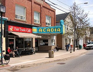
Wolfville is a Canadian town in the Annapolis Valley, Kings County, Nova Scotia, located about 100 kilometres (62 mi) northwest of the provincial capital, Halifax. The town is home to Acadia University and Landmark East School.

<span class="mw-page-title-main">Bay of Fundy</span> Bay on the east coast of North America

The Bay of Fundy is a bay between the Canadian provinces of New Brunswick and Nova Scotia, with a small portion touching the U.S. state of Maine. It is an arm of the Gulf of Maine. Its tidal range is the highest in the world. The name is probably a corruption of the French word fendu, meaning 'split'.

<span class="mw-page-title-main">Annapolis County, Nova Scotia</span> County in Nova Scotia, Canada

Annapolis County is a county in the Canadian province of Nova Scotia located in the western part of the province located on the Bay of Fundy. The county seat is Annapolis Royal.

<span class="mw-page-title-main">Kings County, Nova Scotia</span> County in Nova Scotia, Canada

Kings County is a county in the Canadian province of Nova Scotia. With a population of 62,914 in the 2021 Census, Kings County is the third most populous county in the province. It is located in central Nova Scotia on the shore of the Bay of Fundy, with its northeastern part forming the western shore of the Minas Basin.

<span class="mw-page-title-main">Kentville</span> Town in Nova Scotia, Canada

Kentville is an incorporated town in Nova Scotia. It is the most populous town in the Annapolis Valley. As of 2021, the town's population was 6,630. Its census agglomeration is 26,929.

<span class="mw-page-title-main">Minas Basin</span>

The Minas Basin is an inlet of the Bay of Fundy and a sub-basin of the Fundy Basin located in Nova Scotia, Canada. It is known for its extremely high tides.

<span class="mw-page-title-main">Dominion Atlantic Railway</span>

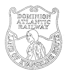
The Dominion Atlantic Railway was a historic railway which operated in the western part of Nova Scotia in Canada, primarily through an agricultural district known as the Annapolis Valley.

New Minas is a village located in the eastern part of Kings County in Nova Scotia's Annapolis Valley. As of 2011, the population was 5,135.

<span class="mw-page-title-main">Grand-Pré, Nova Scotia</span> Community in Nova Scotia, Canada

Grand-Pré is a Canadian rural community in Kings County, Nova Scotia. Its French name translates to "Great/Large Meadow" and the community lies at the eastern edge of the Annapolis Valley several kilometres east of the town of Wolfville on a peninsula jutting into the Minas Basin surrounded by extensive dyked farm fields, framed by the Gaspereau and Cornwallis Rivers. The community was made famous by Henry Wadsworth Longfellow's poem Evangeline and is today home to the Grand-Pré National Historic Site. On June 30, 2012, the Landscape of Grand-Pré was named a World Heritage Site by UNESCO.

<span class="mw-page-title-main">Annapolis River</span> River in Nova Scotia, Canada

The Annapolis River is a Canadian river located in Nova Scotia's Annapolis Valley.

<span class="mw-page-title-main">Nova Scotia Trunk 1</span> Highway in Nova Scotia

Trunk 1 is part of the Canadian province of Nova Scotia's system of Trunk Highways.

<span class="mw-page-title-main">Annapolis Valley Regional Centre for Education</span>

The Annapolis Valley Regional Centre for Education (AVRCE) (formerly Annapolis Valley Regional School Board) is the public school district responsible for the approximately 40 elementary, middle level, and high schools in Annapolis County, Kings County, and the West Hants Municipal District of Hants County in Nova Scotia, Canada. The school district was renamed following the dissolution of elected school boards and placing in Nova Scotia in March 2018.

The Evangeline Trail is a scenic roadway in the Canadian province of Nova Scotia.

<span class="mw-page-title-main">Kings Transit</span>

Kings Transit Authority is a public transit agency operating buses in the Annapolis Valley, Nova Scotia. The system, incorporated in 1981, is funded by Kings County, Annapolis County, Digby County and the towns of Berwick, Wolfville, Kentville, Middleton, Annapolis Royal, and Digby.

<span class="mw-page-title-main">Cornwallis River</span> River in Nova Scotia, Canada

The Cornwallis River is in Kings County, Nova Scotia, Canada. It has a meander length of approximately 48 kilometres (30 mi) through eastern Kings County, from its source on the North Mountain at Grafton to its mouth near Wolfville on the Minas Basin. The lower portion of the river beginning at Kentville is tidal and there are extensive tidal marshes in the lower reaches. In its upper watershed at Berwick, the river draws on the Caribou Bog while a longer branch continues to the official source, a stream on the North Mountain at Grafton.

Kingsport is a small seaside village located in Kings County, Nova Scotia, Canada, on the shores of the Minas Basin. It was famous at one time for building some of the largest wooden ships ever built in Canada.

<span class="mw-page-title-main">Windsor and Annapolis Railway</span>

The Windsor and Annapolis Railway (W&AR) was a historic Canadian railway that operated in Nova Scotia's Annapolis Valley.

<span class="mw-page-title-main">Outline of Nova Scotia</span> Overview of and topical guide to Nova Scotia

The following outline is provided as an overview of and topical guide to Nova Scotia:

Annapolis Valley Regional Library (AVRL) is a public library system based in Annapolis Valley, Nova Scotia, Canada. It serves a population of just over 101,000 in Annapolis County, Kings County and the district of West Hants with eleven branch libraries. Established in 1949, Annapolis Valley Regional Library was the first regional library system in Nova Scotia.
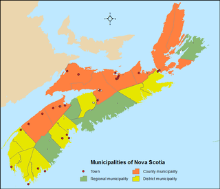
References

  1. Census Profile, 2021 Census of Population, Profile table, Statistics Canada
  2. "The Atlas of Canada - Toporama". Natural Resources Canada. Archived from the original on 2 April 2015. Retrieved 13 March 2015.
  3. "Nova Scotia Local Produce | Seafood | Lobster | Farmers' Markets | Locavore". Tourism Nova Scotia. Archived from the original on 4 September 2019. Retrieved 3 March 2019.
  4. "About the Library". Annapolis Valley Regional Library. Retrieved 11 June 2015.
  5. "Wine Growers Nova Scotia".

45°00′N64°55′W / 45.000°N 64.917°W / 45.000; -64.917