Port-Royal National Historic Site

Last updated

Port-Royal National Historic Site
Port-Royal Nova-Scotia 1.jpg
The entrance into the replica of the Habitation at Port-Royal at the Port-Royal National Historic Site.
Location53 Historic Lane, Granville Ferry, Nova Scotia
Coordinates 44°42′40.55″N65°36′33.0″W / 44.7112639°N 65.609167°W / 44.7112639; -65.609167
Area1 hectare (2.5 acres)
Built1605-1613
Governing body Parks Canada
Canada Nova Scotia location map 2.svg
Red pog.svg
Location of Port-Royal National Historic Site in Nova Scotia
Official namePort-Royal National Historic Site of Canada
DesignatedMay 25, 1923

Port-Royal National Historic Site is a National Historic Site [1] [2] located on the north bank of the Annapolis Basin in Granville Ferry, Nova Scotia, Canada. The site is the location of the Habitation at Port-Royal, [3] which was the centre of activity for the French colony of Port Royal in Acadia from 1605 to 1613 when it was destroyed by English forces from the Colony of Virginia.

Contents

Replica construction in 1939

The replica at Port-Royal National Historic Site Port Royal replica.JPG
The replica at Port-Royal National Historic Site

On May 25, 1925, the national Historic Sites and Monuments Board recognized the original Habitation at for its heritage significance, and the then Minister of the Interior, Charles Stewart, designated it Port-Royal National Historic Site. [4]

In the 1930s, the approximate site of the original Habitation was located in the community and the results of archaeological excavations fed public interest in the period of the original French settlement. This interest had been increasing since the publication of Quietly My Captain Waits, an historical novel by the Canadian novelist Evelyn Eaton set in Port-Royal in the early 17th century.

In the early 1900s, chiefly under the leadership of Harriette Taber Richardson, a native of Cambridge, Massachusetts, and summer resident of the nearby town of Annapolis Royal, Nova Scotian preservationists and historians began lobbying the Government of Canada to build a replica of the Habitation which stood from 1605 until its destruction in 1613.

The government agreed, after much persuasion, to have the replica built on the original site. Construction took place from 1939 to 1941 and was based on a duplicate set of plans for the original Habitation that had been recently discovered in France. This was the first National Historic Site to have a replica structure built.

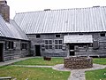
Today, this replica serves as the cornerstone of Port-Royal National Historic Site, and, coupled with nearby Fort Anne National Historic Site in Annapolis Royal, continues to commemorate this important historic region for visitors. Today, the replica of the Habitation is considered a milestone in the national heritage movement. Operated by Parks Canada, it is open to the public as a unit of the national park system, staffed by historical interpreters in period costumes, and is a major tourist attraction. Costumed interpreters provide demonstrations of such historic early 17th-century activities as farming, building, cooking, fur trading and Mi'kmaq life.

Port Royal today.jpg
Port Royal, Annapolis County, Nova Scotia situated on the Annapolis River where it widens to form the Annapolis Basin

See also

Related Research Articles

<span class="mw-page-title-main">Wolfville</span> Town in Nova Scotia, Canada

Wolfville is a Canadian town in the Annapolis Valley, Kings County, Nova Scotia, located about 100 kilometres (62 mi) northwest of the provincial capital, Halifax. The town is home to Acadia University and Landmark East School.

<span class="mw-page-title-main">Acadians</span> Descendants of the 17th-century French colonists who settled in Acadia

The Acadians are an ethnic group descended from the French who settled in the New France colony of Acadia during the 17th and 18th centuries.

<span class="mw-page-title-main">Acadia</span> Colony of New France in northwestern North America

Acadia was a colony of New France in northeastern North America which included parts of what are now the Maritime provinces, the Gaspé Peninsula and Maine to the Kennebec River.

Saint Croix Island, long known to locals as Dochet Island, is a small uninhabited island in Maine near the mouth of the Saint Croix River that forms part of the Canada–United States border separating Maine from New Brunswick. The island is in the heart of the traditional lands of the Passamaquoddy people who, according to oral tradition, used it to store food away from the dangers of mainland animals. The island was the site of an early attempt at French colonization by Pierre Dugua, Sieur de Mons in 1604. In 1984 it was designated by the United States Congress as Saint Croix Island International Historic Site. There is no public access to the island, but there is a visitor contact station on the U.S. mainland and a display on the Canadian mainland opposite the island.

Beaubassin was an important Acadian village and trading centre on the Isthmus of Chignecto in what is now Nova Scotia, Canada. The area was a significant place in the geopolitical struggle between the British and French empires. It was established in the 1670s on an upland close to an extensive area of saltwater marsh. Settlers reclaimed the land to engage in cattle ranching and trade.

<span class="mw-page-title-main">Annapolis Royal</span> Town and county seat in Nova Scotia, Canada

Annapolis Royal is a town in and the county seat of Annapolis County, Nova Scotia, Canada. The community, known as Port Royal before 1710, is recognised as having one of the longest histories in North America, preceding the settlements at Plymouth, Jamestown and Quebec. For nearly 150 years, it served as the capital of Acadia and subsequently Nova Scotia until the establishment of Halifax in 1749.

<span class="mw-page-title-main">Fort Beauséjour</span> Fort in Aulac, New Brunswick, Canada

Fort Beauséjour, renamed Fort Cumberland in 1755, is a large, five-bastioned fort on the Isthmus of Chignecto in eastern Canada, a neck of land connecting the present-day province of New Brunswick with that of Nova Scotia. The site was strategically important in Acadia, a French colony that included primarily the Maritimes, the eastern part of Quebec, and northern Maine of the later United States. The fort was built by the French from 1751 to 1752. They surrendered it to the British in 1755 after their defeat in the Battle of Fort Beauséjour, during the Seven Years' War. The British renamed the structure as Fort Cumberland. The fort was strategically important throughout the Anglo-French rivalry of 1749–63, known as the French and Indian Wars by British colonists. Less than a generation later, it was the site of the 1776 Battle of Fort Cumberland, when the British forces repulsed sympathisers of the American Revolution.

<span class="mw-page-title-main">Fort Anne</span> Historic fort in Nova Scotia, Canada

Fort Anne is a historic fort protecting the harbour of Annapolis Royal, Nova Scotia. It was built by Scottish settlers in August 1629 as Charles Fort. For the first 120 years of the fort's service period, the settlement of Port Royal, later Annapolis Royal, was the capital of the New France colony of Acadia and British North America colony of Nova Scotia. In 1917, Fort Anne became the first National Historic Site of Canada. Although no longer in active service, it is the oldest extant fort in Canada. Fort Anne has provided more defensive service than any other fort in North America, having been attacked and blockaded at least 19 times over a service period of 225 years, from the Acadian Civil War through to the American Revolutionary War. The fort also contains the oldest military building in Canada and the oldest building administered by Parks Canada, the 1708 powder magazine.

<span class="mw-page-title-main">Grand-Pré, Nova Scotia</span> Community in Nova Scotia, Canada

Grand-Pré is a Canadian rural community in Kings County, Nova Scotia. Its French name translates to "Great/Large Meadow" and the community lies at the eastern edge of the Annapolis Valley several kilometres east of the town of Wolfville on a peninsula jutting into the Minas Basin surrounded by extensive dyked farm fields, framed by the Gaspereau and Cornwallis Rivers. The community was made famous by Henry Wadsworth Longfellow's poem Evangeline and is today home to the Grand-Pré National Historic Site. On June 30, 2012, the Landscape of Grand-Pré was named a World Heritage Site by UNESCO.

<span class="mw-page-title-main">Grand-Pré National Historic Site</span> Historic site in Grand-Pré, Nova Scotia

Grand-Pré National Historic Site is a park set aside to commemorate the Grand-Pré area of Nova Scotia as a centre of Acadian settlement from 1682 to 1755, and the British deportation of the Acadians that happened during the French and Indian War. The original village of Grand Pré extended four kilometres along the ridge between present-day Wolfville and Hortonville. Grand-Pré is listed as a World Heritage Site and is the main component of two National Historic Sites of Canada.

<span class="mw-page-title-main">History of the Acadians</span> Acadia viewed from a historical point of view

The Acadians are the descendants of 17th and 18th century French settlers in parts of Acadia in the northeastern region of North America comprising what is now the Canadian Maritime Provinces of New Brunswick, Nova Scotia and Prince Edward Island, the Gaspé peninsula in eastern Québec, and the Kennebec River in southern Maine.

Charles de Saint-Étienne de La Tour (1593–1666) was a Huguenot French colonist and fur trader who served as Governor of Acadia from 1631–1642 and again from 1653–1657.

<span class="mw-page-title-main">LaHave, Nova Scotia</span> Community in Nova Scotia, Canada

LaHave is a Canadian community in Lunenburg County, Nova Scotia. The community is located across the river from Riverport and approximately 15 kilometres from the town of Bridgewater. Once the capital of Acadia, it is located on Highway 331 at the mouth of the 97 km long LaHave River.

<span class="mw-page-title-main">Battle of Bloody Creek (1711)</span> Battle of the Queen Annes War in 1711

The Battle of Bloody Creek was fought on 10/21 June 1711 during Queen Anne's War. An Abenaki militia successfully ambushed British soldiers at a place that became known as Bloody Creek after the battles fought there. The creek empties into the Annapolis River at present day Carleton Corner, Nova Scotia, and was also the location of a battle in 1757.

<span class="mw-page-title-main">Siege of Port Royal (1710)</span> Part of Queen Annes War

The siege of Port Royal, also known as the Conquest of Acadia, was a military siege conducted by British regular and provincial forces under the command of Francis Nicholson against a French Acadian garrison and the Wabanaki Confederacy under the command of Daniel d'Auger de Subercase, at the Acadian capital, Port Royal. The successful British siege marked the beginning of permanent British control over the peninsular portion of Acadia, which they renamed Nova Scotia, and it was the first time the British took and held a French colonial possession. After the French surrender, the British occupied the fort in the capital with all the pomp and ceremony of having captured one of the great fortresses of Europe, and renamed it Annapolis Royal.

<span class="mw-page-title-main">Duc d'Anville expedition</span>

The Duc d'Anville expedition was sent from France to recapture Louisbourg and take peninsular Acadia. The expedition was the largest military force ever to set sail for the New World prior to the American Revolutionary War. This effort was the fourth and final French attempt to regain the Nova Scotian capital, Annapolis Royal, during King George's War. The Expedition was also supported on land by a force from Quebec under the command of Jean-Baptiste Nicolas Roch de Ramezay. Along with recapturing Acadia from the British, d'Anville was ordered to "consign Boston to flames, ravage New England and waste the British West Indies." News of the expedition spread fear throughout New York and New England.

<span class="mw-page-title-main">Acadian Civil War</span> Civil war in New France

The Acadian Civil War (1635–1654) was fought between competing governors of the French province of Acadia. Governor Charles de Saint-Étienne de la Tour had been granted one area of territory by King Louis XIV, and Charles de Menou d'Aulnay had been granted another area. The divisions made by the king were geographically uninformed, and the two territories and their administrative centres overlapped. The conflict was intensified by personal animosity between the two governors, and came to an end when d'Aulnay successfully expelled la Tour from his holdings. D'Aulnay's success was effectively overturned after his death when la Tour married D'Aulnay's widow in 1653.

<span class="mw-page-title-main">Port-Royal (Acadia)</span> Historic settlement in modern-day Nova Scotia, Canada

Port Royal (1605–1713) was a historic settlement based around the upper Annapolis Basin in Nova Scotia, Canada, and the predecessor of the modern town of Annapolis Royal.

<span class="mw-page-title-main">Acadia River</span> River in Canada

The Acadia River flows Northerly over 82 km through seven municipalities in the MRC La Vallée-du-Richelieu, Les Jardins-de-Napierville and Le Haut-Richelieu, in Montérégie, on the South Shore of St. Lawrence river, the Quebec, Canada. The Acadia river empties into the Richelieu River, in Carignan, skirting the city of Chambly by the north.

<span class="mw-page-title-main">Outline of Nova Scotia</span> Overview of and topical guide to Nova Scotia

The following outline is provided as an overview of and topical guide to Nova Scotia:

References

Notes
    Citations
    Primary sources
    Secondary sources