Halifax Citadel-Sable Island is a provincial electoral district in Halifax, Nova Scotia, Canada, that elects one member of the Nova Scotia House of Assembly.

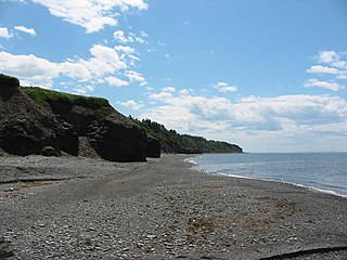
Arisaig, is a small village in Antigonish County, Nova Scotia, Canada. It is located on the north coast of eastern mainland Nova Scotia, on the Northumberland Strait, and is connected to the town of Antigonish to the southeast and to New Glasgow to the west by Route 245, the "Sunrise Trail". Nearby communities include Doctors Brook, Malignant Cove, Knoydart, and McArras Brook.
Dalem Lake Provincial Park is a provincial park located in the Canadian province of Nova Scotia on Boularderie Island.

Rodney Joseph MacDonald is a Canadian politician, educator and musician who served as the 26th premier of Nova Scotia from 2006 to 2009 and as MLA for the riding of Inverness in the Nova Scotia House of Assembly from 1999 to 2009.

Victoria—The Lakes is a provincial electoral district in Nova Scotia, Canada, that elects one member of the Nova Scotia House of Assembly.

The Sunrise Trail is a scenic roadway in the Canadian province of Nova Scotia. It is located along the province's North Shore on the Northumberland Strait for 333 km (207 mi) from Amherst to the Canso Causeway.
Route 245 is a collector road in the Canadian province of Nova Scotia. Route 245 is part of the Sunrise Trail.

Cape Chignecto Provincial Park is a Canadian provincial park located in Nova Scotia. A wilderness park, it derives its name from Cape Chignecto, a prominent headland which divides the Bay of Fundy with Chignecto Bay to the north and the Minas Channel leading to the Minas Basin to the east. The park, which opened in 1998, is the largest provincial park in Nova Scotia. It also anchors one end of the UNESCO Cliffs of Fundy Global Geopark.
Daniel McDonald was a lawyer and political figure in Nova Scotia, Canada. He represented Antigonish County in the Nova Scotia House of Assembly from 1867 to 1878 as a Liberal member.

Uisge Ban Falls Provincial Park is a provincial park near New Glen, in the Canadian province of Nova Scotia on Cape Breton Island. Located on the North Branch Road 14.5 kilometres (9.0 mi) north of Baddeck, the civic address of the park entrance is 715 North Branch Road, Baddeck Forks, Nova Scotia, Canada B0E 1B0.

Ben Eoin Provincial Park is a small secluded provincial park on an old farm against hardwood-covered hills in the community of Ben Eoin, Nova Scotia, Canada, on the south side of the East Bay of the Bras d'Or Lake, on Cape Breton Island. This picnic and hiking park is managed by the provincial Department of Natural Resources and is situated on a heavily wooded 225 acres (91 ha) parcel of Crown land. A short distance into the park there are several large neatly mown clearings with picnic tables under the trees at the edge of the small fields. Pit toilets and disposal areas for hot coals are available onsite.
MacCormack Provincial Park is a small picnic park overlooking the Bras d'Or Lake, in the community of Plaster Cove, in the Canadian province of Nova Scotia, located in Victoria County on Cape Breton Island. The park entrance is on St. Columba Road, just 0.3 kilometres (0.19 mi) north of Iona, Nova Scotia.

Halifax Armdale is a provincial electoral district in Nova Scotia, Canada, that elects one member of the Nova Scotia House of Assembly. This Halifax district covers the growing population of the Fairmount, Armdale and Cowie Hill areas. The northern boundary is Highway 102, the eastern boundary is Joseph Howe Drive and the Northwest Arm, while the southern boundary is Frog Pond Park in Armdale.

Clayton Park West is a provincial electoral district in Nova Scotia, Canada, that elects one member of the Nova Scotia House of Assembly.

Fairview-Clayton Park is a provincial electoral district in Nova Scotia, Canada, that elects one member of the Nova Scotia House of Assembly. The riding was created in 2012 with 45 per cent of the former district of Halifax Fairview, 39 per cent of the former district of Halifax Clayton Park and 10 per cent of Halifax Chebucto.

Timothy Jerome Houston is a Canadian politician who is the 30th and current premier of Nova Scotia since 2021. He was first elected to the Nova Scotia House of Assembly in the 2013 provincial election. A member of the Progressive Conservative Party of Nova Scotia, he represents the electoral district of Pictou East. Houston also served as the leader of the opposition from 2018 to 2021. He and the Progressive Conservative party won a majority government in the 2021 Nova Scotia general election, becoming the first Progressive Conservative premier since 2009.

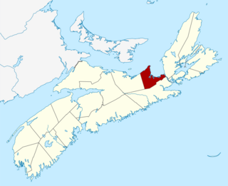
Antigonish County is a historical county and census division of Nova Scotia, Canada. Local government is provided by the Municipality of the County of Antigonish, the Town of Antigonish, and by two reserves: Pomquet and Afton 23, and Summerside 38.

Lennox Passage Provincial Park is a small picnic and beach park on the shores of Lennox Passage on the North Shore of Isle Madame on Cape Breton Island, Nova Scotia, with 2 kilometres (1.2 mi) of shoreline, an operating lighthouse and site of a former post office, ferry terminal and two limestone quarries. Visitors can picnic at tables scattered through a forest and open areas, enjoy the 2 kilometres (1.2 mi) of trails, or explore the working lighthouse. In summer the park offers swimming, kayaking, and biking opportunities. There are snowshoeing and cross-country skiing opportunities in the winter, however parking is available at the gate only in the off-season.

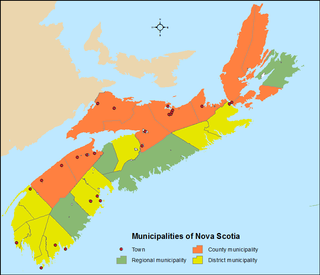
The Canadian province of Nova Scotia is divided into 49 municipalities, of which there are three types: regional (4), town (25), and county or district municipality (20).


