Kejimkujik National Park is a national park of Canada, covering 404 km2 (156 sq mi) in the southwest of Nova Scotia peninsula. Located within three municipalities, Annapolis, Queens, Digby, it consists of two separate land areas: an inland part, which is coincident with the Kejimkujik National Historic Site of Canada, and the Kejimkujik National Park Seaside on the Atlantic coast.

Spryfield is community within the urban area of Halifax, Nova Scotia, Canada.

Frontenac Provincial Park is a provincial park located near the town of Sydenham, north of Kingston, Ontario, Canada. This 5,350 ha (13,200-acre) park is classified as a natural environment park, and lies on the Frontenac Axis, a topographic extension of the Canadian Shield connecting to the Adirondack Mountains. It features 22 lakes, over 700 species, and extensive areas of mixed forest, wetlands, and granite outcrops.

The Eastern Shore is a region of the Canadian province of Nova Scotia. It is the Atlantic coast running northeast from Halifax Harbour to the eastern end of the peninsula at the Strait of Canso.

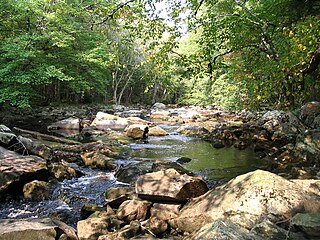
The Musquodoboit River is a Canadian river located in central Nova Scotia in the northeastern part of Halifax Regional Municipality. The river is approximately 97 kilometres (60 mi) in length with roughly 88 kilometres (55 mi) being traversable by paddle. It has a watershed area of 1,409 square kilometres (544 sq mi)
Cole Harbour is the name for a natural harbour located in the Canadian province of Nova Scotia.
Timberlea is a community located within the Municipality of Halifax in Nova Scotia, Canada.

Long Lake Provincial Park is located in Halifax, Nova Scotia, Canada. It was initiated in 1981 by then Premier John Buchanan after Halifax's water supply had been shifted from the Spruce Hill/Long Lake/Chain Lakes watershed to the Pockwock Lake watershed near Hammonds Plains. The 2,095-hectare (5,180-acre) park, formally established in 1984, constitutes the bulk of these former watershed lands. Other portions were deeded to the municipality of Halifax, and the area around the Chain Lakes is still administered by the Halifax Regional Water Commission, since the Chain Lakes remain the city's emergency water supply.

The Trinity Alps Wilderness is a 525,627-acre (212,714 ha) designated wilderness located in northern California, roughly between Eureka and Redding. It is jointly administered by Shasta-Trinity, Klamath, and Six Rivers National Forests. About 4,623 acres (1,871 ha) are administered by the Bureau of Land Management. The wilderness is located in the Salmon and Scott Mountains, subranges of the Klamath Mountains region. The high, granitic and ultramafic peaks of the eastern half of the wilderness area are known as the Trinity Alps. Granite peaks at the core of the area are known as the White Trinities, reddish ultramafic peaks in the southeast are known as the Red Trinities, and the forested mountains in the western half of the wilderness are known as the Green Trinities.
Scouting in Nova Scotia has a long history, from 1908 to the present day. There is early record of Boys' Brigade scouts, Canadian Boy Scouts and Salvation Army's Life-Saving Scouts in Nova Scotia. Scouting in Nova Scotia is currently conducted by local Scout groups and various associations including Scouts Canada, L'Association des Scouts du Canada and Canadian Federation of Independent Scouts affiliates such as BPSA - Nova Scotia.

Musquodoboit Harbour is a rural community located in Nova Scotia, Canada within the Halifax Regional Municipality. The community is situated on the Eastern Shore at the mouth of the Musquodoboit River. The community lies 45 kilometres east of downtown Halifax. With a hospital, RCMP detachment, postal outlet, schools, recreational center, library, municipal office and other services, Musquodoboit Harbour is a serve centre for many of the surrounding communities.

Lake Egmont is a small rural community in the lower interior of the Musquodoboit Valley, in the Halifax Regional Municipality of Nova Scotia, Canada. Other communities in this area include Antrim and Wyses Corner, Nova Scotia. The community was named after John Perceval, 2nd Earl of Egmont.
Liscomb Game Sanctuary is a conservation area that straddles the border of Halifax Regional Municipality and Guysborough County in the Canadian province of Nova Scotia. Nova Scotia Route 374 runs north–south through the sanctuary. Within the sanctuary are two nature reserves and parts of two wilderness areas.
Gibraltar is a rural community of the Halifax Regional Municipality in the Canadian province of Nova Scotia on Nova Scotia Route 357, approximately 15 km north of Musquodoboit Harbour.

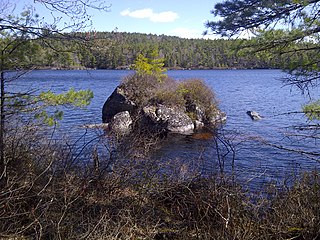
Eunice Lake is a lake located in the Ship Harbour Long Lake Wilderness Area in Nova Scotia, Canada. It can only be accessed by the Admiral Lake Loop of the Musquodoboit Trailways Association. The lake is about 320 meters long and 190 meters wide. The trailhead is about 2 km north of Musquodoboit Harbour.
The Waverley - Salmon River Long Lake Wilderness Area is a provincial wilderness area located about 20 kilometers east of Dartmouth Nova Scotia, Canada.
The Musquodoboit Trailway is a 14.5-kilometre-long (9.0 mi) multiuse rail trail located in Halifax County, Nova Scotia, running the distance from Gibralter to Musquodoboit Harbour. The entire route is part of the Halifax spur of The Great Trail, and follows Nova Scotia Route 357 for its length.

The Eastern Shore Granite Ridge, also known as the Musquodoboit Batholith, is a range of prominent hills averaging 100-125m (330-410ft) in height, located just inland from the Eastern Shore of Nova Scotia. Geologically, it is related to the much larger South Mountain Batholith, but the two are geologically distinct areas. Many of the hills have steep cliffs on one or more of their sides, some featuring vertical drops in excess of 50m (160ft); as a result, many of the taller hills offer extensive views despite their relatively low elevation.

The Eastern Shore is a tourism region of the province of Nova Scotia, Canada. It provides two percent of the revenue for the province's tourism economy. One of its key features is an archipelago known as the 100 Wild Islands area.

Tangier Grand Lake Wilderness Area is a relatively large wilderness area located within the province of Nova Scotia, Canada, centered on its namesake lake, Tangier Grand Lake, the largest lake in Nova Scotia which does not have direct road access.

