Cape Chignecto Provincial Park

Last updated
Cape Chignecto Provincial Park
Capechignectoprovpark.jpg
The cliffs of Cape Chignecto viewed from Red Rocks trailhead and visitor centre
Location Nova Scotia, Canada
Nearest city Amherst, Nova Scotia, Truro, Nova Scotia
Coordinates 45°21′01″N64°49′30.5″W / 45.35028°N 64.825139°W / 45.35028; -64.825139 Coordinates: 45°21′01″N64°49′30.5″W / 45.35028°N 64.825139°W / 45.35028; -64.825139
Area42 km2 (16 sq mi), 4,200 ha (10,000 acres)
Established1989
Governing body Nova Scotia Department of Natural Resources

Cape Chignecto Provincial Park is a Canadian provincial park located in Nova Scotia. A wilderness park, it derives its name from Cape Chignecto, a prominent headland which divides the Bay of Fundy with Chignecto Bay to the north and the Minas Channel leading to the Minas Basin to the east. The park, which opened in 1998, is the largest provincial park in Nova Scotia. It also anchors one end of the UNESCO Cliffs of Fundy Global Geopark. [1]

Contents

Landscape

The park's landscape is renowned for spectacular shoreline with extensive backpacking trails and scenic day hikes. The highest cliffs in Mainland Nova Scotia are located along the park's southern coast, measuring 200 metres (600 ft). The park occupies 42 square kilometres (16 sq mi) and has 30 kilometres (19 mi) of wilderness coastline with unique geological features such as raised beaches, caves and sea stacks. The complex geology was created by continental collision along the Cobequid fault. The spectacular coastal landscapes of the park make it popular for hikers and kayakers. It also contains several abandoned logging camps, saw mills and the ghost towns of Eatonville and New Yarmouth. A secluded ravine named Refugee Cove was the site where Mi'kmaq sheltered fleeing Acadians during the Expulsion of the Acadians.

The mixing of warm summer temperatures with the cold tidal waters of the Bay of Fundy create frequent fogs resulting in moist rain forest-like conditions which nurture "fog forests" of large red spruce and many unique and endangered species of lichens. The park's high southern cliffs support species of vetch and primrose with Alpine characteristics which are unique in Nova Scotia. [2] Cape Chignecto also provides shelter for Nova Scotia's endangered mainland moose herd.

Tides rise and fall 12 metres along the park's coastline, producing rip currents and rapid flooding at certain points. Several hikers have been trapped and had to be rescued when rising tides trapped them against sheer cliffs, including a couple and a dog who had to be rescued from rising waters at Eatonville by a helicopter from CFB Greenwood in July 2014. [3]

Facilities

The park maintains over 50 kilometres of trails, both for day use hikers and overnight backpackers. An interpretation centre, picnic area, washrooms and giftshop are based at the trailhead at Red Rocks near the community of Advocate Harbour. In addition to 51 back country campsites and 28 walk-in sites, several overnight cabins and bunk houses on the trail system may be rented by hikers. A mothballed fire tower, closed since 2012, is located at the highest point of the park in New Yarmouth. [4] A new, off-grid interpretation centre and day use trails at Eatonville were constructed in 2008–2009. Partially funded by a federal-provincial contribution of $350,000 announced in July 2008, [5] the centre's completion was delayed by bad weather but opened on July 30, 2009. The Cape Chignecto Trails are part of the 400 km Cape to Cape hiking trail system under construction to connect Cape Chignecto with Cape George, Antigonish County. [6] The park is open from mid June to mid October. [7] It is accessible from Route 209 and is one of the features on the Fundy Shore Ecotour.

History of the park

The Government of Nova Scotia purchased the land currently comprising the park in 1989 and added it to the Crown land reserve, administered by the Department of Natural Resources. This land was redesignated for a provincial park in the mid-1990s and Cape Chignecto Provincial Park opened to the public in 1998 after several years of planning and trail and campsite development. By area, Cape Chignecto is the largest provincial park in Nova Scotia.

Although Cape Chignecto is Nova Scotia's largest provincial park and is owned administered by Nova Scotia's Department of Natural Resources, it was created, and until 2012, run by a local community development organization, the Cumberland Regional Economic Development Association. The park was operated by a very small seasonal staff based in Advocate and Amherst, Nova Scotia. However, in the spring of 2012 the Department of Natural Resources took over management of the park and brought its fees in line with other provincial parks. In 2020, the Park was designated as part of the UNESCO "Cliffs of Fundy Global Geopark with the Three Sisters Day Use trails at Eatonville marking the beginning of the Geopark which stretches all around Cape Chignecto and down the coast to Debert. [8] [9]

Pictures

Related Research Articles

<span class="mw-page-title-main">Bay of Fundy</span> Bay on the east coast of North America

The Bay of Fundy is a bay between the Canadian provinces of New Brunswick and Nova Scotia, with a small portion touching the U.S. state of Maine. It is an arm of the Gulf of Maine. Its extremely high tidal range is the highest in the world. The name is likely a corruption of the French word fendu, meaning 'split'.

<span class="mw-page-title-main">Fundy National Park</span> Located on the Bay of Fundy, near the village of Alma, New Brunswick

Fundy National Park is a national park of Canada located on the Bay of Fundy, near the village of Alma, New Brunswick. It was officially opened on 29 July 1950. The park showcases a rugged coastline which rises up to the Canadian Highlands, the highest tides in the world and more than 25 waterfalls. The park covers an area of 207 km2 (80 sq mi) along Goose Bay, the northwestern branch of the Bay of Fundy. When one looks across the Bay, one can see the northern Nova Scotia coast.

<span class="mw-page-title-main">Minas Basin</span> Body of water

The Minas Basin is an inlet of the Bay of Fundy and a sub-basin of the Fundy Basin located in Nova Scotia, Canada. It is known for its extremely high tides.

<span class="mw-page-title-main">Blomidon Provincial Park</span>

Blomidon Provincial Park is a camping and day-use park located at Cape Blomidon on the shores of the Minas Basin in Nova Scotia, Canada. It is known for its hiking, and the views over the world's highest tides. Blomidon is located on 1,875 acres (7.6 km2) of land with 600 ft high cliffs. It is accessible via Nova Scotia Route 358.

<span class="mw-page-title-main">Advocate Harbour</span> Village in Nova Scotia, Canada

Advocate Harbour is a rural community located in Cumberland County, Nova Scotia, Canada.

<span class="mw-page-title-main">Joggins</span> Community in Nova Scotia, Canada

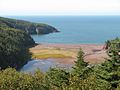
Joggins is a rural community located in western Cumberland County, Nova Scotia, Canada. On July 7, 2008 a 15-km length of the coast constituting the Joggins Fossil Cliffs was officially inscribed on the World Heritage List.

<span class="mw-page-title-main">Cape Split</span>

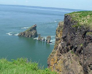
Cape Split is a headland located on the Bay of Fundy coast of the Canadian province of Nova Scotia. The Battle off Cape Split happened during the American Revolution.

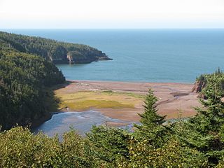
The Glooscap Trail is a scenic roadway in the Canadian province of Nova Scotia.

The Fundy Shore Ecotour is a former scenic drive and network of tourist destinations in the Canadian province of Nova Scotia and encircles several sub-basins of the Bay of Fundy, which contains the highest tidal range on the planet.

<span class="mw-page-title-main">Geography of Nova Scotia</span>

Nova Scotia is a province located in Eastern Canada fronting the Atlantic Ocean. One of the Maritime Provinces, Nova Scotia's geography is complex, despite its relatively small size in comparison to other Canadian provinces.

<span class="mw-page-title-main">Partridge Island (Nova Scotia)</span>

Partridge Island is a significant historical, cultural and geological site located near the mouth of Parrsboro Harbour and the town of Parrsboro on the Minas Basin, in Cumberland County, Nova Scotia. It attracts many visitors including sightseers, swimmers, photographers, hikers and amateur geologists. Partridge Island is actually a peninsula that is connected to the mainland by a sandbar isthmus. According to local legend, the isthmus was created during the Saxby Gale of 1869. The hiking trail to the top of the island affords scenic views of key landforms on the Minas Basin including Cape Blomidon, Cape Split and Cape Sharp. The nearby Ottawa House By-the-Sea Museum contains artifacts and exhibits illustrating the history of the former village at Partridge Island, which dates from the 1770s. Partridge Island is a favourite hunting ground for rockhounds because its ancient sandstone and basalt cliffs are steadily eroded by the fast-moving currents of the world's highest tides. Rocks and debris worn away from its cliffs are dragged down the beach making it possible to find gemstones, exotic-looking zeolite minerals and fossils. Fossil hunters are warned, however, that although one or two loose specimens may be collected, Nova Scotia law requires that they be sent or taken to a museum for further study, and no fossils may be excavated from bedrock without a permit.

<span class="mw-page-title-main">Tourism in New Brunswick</span>

There are two major national parks. The warmest salt water beaches north of Virginia can be found on the Northumberland Strait, at Parlee Beach in Shediac. New Brunswick's signature natural attraction are only a half hour's drive down the Petitcodiac river valley. The Confederation Bridge to Prince Edward Island is only an hour's drive east of Moncton.

<span class="mw-page-title-main">Cape Chignecto</span>

Cape Chignecto is a headland located on the Bay of Fundy coast of the Canadian province of Nova Scotia.

<span class="mw-page-title-main">Eatonville, Nova Scotia</span> Ghost town in Nova Scotia, Canada

Eatonville is a former lumber and shipbuilding village in Cumberland County, Nova Scotia. It includes a large tidal harbour at the mouth of the Eatonville Brook beside several dramatic sea stacks known as the "Three Sisters". It was founded in 1826 and abandoned in the 1940s. The site of the village is now part of Cape Chignecto Provincial Park.

New Yarmouth is an abandoned farming and forestry community which is now part of the Cape Chignecto Provincial Park in Cumberland County, Nova Scotia near the village of Advocate.

<span class="mw-page-title-main">Uisge Ban Falls Provincial Park</span> Provincial park in Nova Scotia, Canada

Uisge Ban Falls Provincial Park is a provincial park near New Glen, in the Canadian province of Nova Scotia on Cape Breton Island. Located on the North Branch Road 14.5 kilometres (9.0 mi) north of Baddeck, the civic address of the park entrance is 715 North Branch Road, Baddeck Forks, Nova Scotia, Canada B0E 1B0.

<span class="mw-page-title-main">Cape d'Or</span> Lighthouse

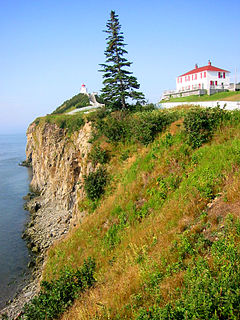
Cape d'Or is a headland located near Advocate, Cumberland County, on the Bay of Fundy coast of the Canadian province of Nova Scotia.

<span class="mw-page-title-main">Outline of Nova Scotia</span> Overview of and topical guide to Nova Scotia

The following outline is provided as an overview of and topical guide to Nova Scotia:

<span class="mw-page-title-main">Tourism in Nova Scotia</span>

Nova Scotia has two major national parks, Cape Breton Highlands National Park and Kejimkujik National Park. Nova Scotia is also home to three UNESCO world heritage sites. The two cultural and one natural site are the town of Old Lunenberg, the Grand-Pré National Historic Site, and the Joggins fossil cliffs. Nova Scotia is also famous for its numerous historical sites, museums, and natural areas.

The Fundy Shore Scenic Drive is a scenic drive in the Canadian province of Nova Scotia. It located along the northeastern portion of the Bay of Fundy, following the Chignecto Peninsula which separates Chignecto Bay and Minas Basin, an area which contains the highest tidal range on the planet.

References

  1. Francis Campbell, "Nova Scotia's Cliffs of Fundy designated UNESCO Global Geopark site", Halifax Chronicle Herald, July 10, 2020.
  2. "Cape Chignecto: Incredible Coastline", Interpretive Guide and Map, (2005) Nova Scotia Dept. of Natural Resources
  3. "Darrell Cole, "Couple, dog plucked from beach at Eatonville", Amherst News-Parrsboro Citizen Record, July 11, 2014". Archived from the original on September 23, 2015. Retrieved July 19, 2014.
  4. "Nova Scotia Department of Natural Resources Fire Towers", Maritimes Scanning Site
  5. Tom McCoag, "Cash for Cape Chignecto", Halifax Chronicle Herald, July 16, 2088, p. B4
  6. Cape to Cape Trail website Archived September 11, 2010, at the Wayback Machine
  7. "Cape Chignecto", Nova Scotia Provincial Parks, Nova Scotia Dept. of Lands and Forestry
  8. "Cape Chignecto Provincial Park Day Fees Eliminated" NS Department of Natural Resources, July 12, 2013
  9. Francis Campbell, "Nova Scotia's Cliffs of Fundy designated UNESCO Global Geopark site", Halifax Chronicle Herald, July 10, 2020. and "Three Sisters", Cliffs of Fundy Geopark