
Mississagi Provincial Park is a natural environment-class provincial park north of Elliot Lake, in Algoma District, Ontario, Canada. It lies on the Boland River, a tributary of the Little White River, which is itself a tributary of the Mississagi River. The park is accessed via Highway 639.
Ontario Parks is a branch of the Ministry of the Environment, Conservation and Parks in Ontario, Canada, that protects significant natural and cultural resources in a system of parks and protected areas that is sustainable and provides opportunities for inspiration, enjoyment and education. The Ontario Parks system covers over 78,000 square kilometres (30,000 sq mi), which is about 10 per cent of the province's surface area or the equivalent of an area approximately equal to Nova Scotia. It falls under the responsibility and mandate of the province's Ministry of the Environment, Conservation and Parks. It was formerly under the mandate of the Ministry of Natural Resources and Forestry.

Blomidon Provincial Park is a camping and day-use provincial park located at Cape Blomidon on the shores of the Minas Basin in Nova Scotia, Canada. It is known for its hiking and for views over the world's highest tides. Blomidon is located on 1,875 acres (7.6 km2) of land with 600 ft high cliffs. It is accessible via Nova Scotia Route 358.
Dalem Lake Provincial Park is a provincial park located in the Canadian province of Nova Scotia on Boularderie Island.
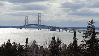
Straits State Park is a state park in the U.S. state of Michigan located in Moran Township and St. Ignace in Mackinac County on the northern shores of the Straits of Mackinac. The Father Marquette National Memorial and park is also located within the state park boundaries. The park has 255 campsites and several locations for viewing the Mackinac Bridge.

Long Lake Provincial Park is located in Halifax, Nova Scotia, Canada. It was initiated in 1981 by then Premier John Buchanan after Halifax's water supply had been shifted from the Spruce Hill/Long Lake/Chain Lakes watershed to the Pockwock Lake watershed near Hammonds Plains. The 2,095-hectare (5,180-acre) park, formally established in 1984, constitutes the bulk of these former watershed lands. Other portions were deeded to the municipality of Halifax, and the area around the Chain Lakes is still administered by the Halifax Regional Water Commission, since the Chain Lakes remain the city's emergency water supply.
Holly River State Park is a state park located in Webster County, West Virginia. Situated on the Left Fork of the Holly River near the town of Hacker Valley, it is the second largest park in the West Virginia state park system with a total of 8,294 acres (3,356 ha). The park features over 42 miles (68 km) of hiking trails, ten vacation cabins, an 88-unit campground, and many recreation and picnic areas.

Cape Chignecto Provincial Park is a Canadian provincial park located in Nova Scotia. A wilderness park, it derives its name from Cape Chignecto, a prominent headland which divides the Bay of Fundy with Chignecto Bay to the north and the Minas Channel leading to the Minas Basin to the east. The park, which opened in 1998, is the largest provincial park in Nova Scotia. It also anchors one end of the UNESCO Cliffs of Fundy Global Geopark.

Mount Carleton Provincial Park, established in 1970, is the largest provincial park in the Province of New Brunswick, Canada. It encompasses 174 square kilometres (67 sq mi) in the remote highlands of north-central New Brunswick. The park is a lesser-known gem of the Atlantic Canadian wilderness. Some outdoor enthusiasts refer to it as the "Algonquin of New Brunswick."
Groves Point is a community in the Canadian province of Nova Scotia, located in the Cape Breton Regional Municipality.
Narrow Hills Provincial Park is a northern boreal forest provincial recreational park in the Canadian province of Saskatchewan. It is located in a hilly plateau called the Cub Hills and contains several recreational facilities and over 25 accessible lakes within its boundaries. The geographical features of the park, including the lakes, valleys, and lowlands were formed over 10,000 years ago during the last ice age. The town of Smeaton is the closest community and it is located 70 kilometres (43 mi) to the south.

Uisge Ban Falls is a waterfall near Baddeck, Nova Scotia, Canada. The falls is located in Uisge Ban Falls Provincial Park near New Glen, Victoria County, 14.5 kilometres north of Baddeck.
Uisge Ban Falls Provincial Park is a provincial park near New Glen, in the Canadian province of Nova Scotia on Cape Breton Island. Located on the North Branch Road 14.5 kilometres (9.0 mi) north of Baddeck, the civic address of the park entrance is 715 North Branch Road, Baddeck Forks, Nova Scotia, Canada B0E 1B0.

Ben Eoin Provincial Park is a small secluded provincial park on an old farm against hardwood-covered hills in the community of Ben Eoin, Nova Scotia, Canada, on the south side of the East Bay of the Bras d'Or Lake, on Cape Breton Island. This picnic and hiking park is managed by the provincial Department of Natural Resources and is situated on a heavily wooded 225 acres (91 ha) parcel of Crown land. A short distance into the park there are several large neatly mown clearings with picnic tables under the trees at the edge of the small fields. Pit toilets and disposal areas for hot coals are available onsite.
MacCormack Provincial Park is a small picnic park overlooking the Bras d'Or Lake, in the community of Plaster Cove, in the Canadian province of Nova Scotia, located in Victoria County on Cape Breton Island. The park entrance is on St. Columba Road, just 0.3 kilometres (0.19 mi) north of Iona, Nova Scotia.

Cabots Landing Provincial Park is a small picnic and beach park on the shore of Aspy Bay in the community of Sugarloaf, 10 kilometres (6.2 mi) north of the Cabot Trail on Cape Breton Island, Nova Scotia, Canada.

Lennox Passage Provincial Park is a small picnic and beach park on the shores of Lennox Passage on the North Shore of Isle Madame on Cape Breton Island, Nova Scotia, with 2 kilometres (1.2 mi) of shoreline, an operating lighthouse and site of a former post office, ferry terminal and two limestone quarries. Visitors can picnic at tables scattered through a forest and open areas, enjoy the 2 kilometres (1.2 mi) of trails, or explore the working lighthouse. In summer the park offers swimming, kayaking, and biking opportunities. There are snowshoeing and cross-country skiing opportunities in the winter, however parking is available at the gate only in the off-season.
Mira River Provincial Park is a provincial park situated on the Mira River in Cape Breton County, Nova Scotia, 22 kilometres (14 mi) from Sydney and 17 kilometres (11 mi) from the Fortress of Louisbourg National Historic Site of Canada. Opened in 1967, the 87.49 hectares property offers camping sites and a range of opportunities for outdoor recreation, including picnicking, swimming, canoeing, kayaking, biking, front-country hiking, boating, fishing, cross-country skiing, snowshoeing, and geocaching.
Porcupine Hills Provincial Park is the newest provincial park in the Canadian Province of Saskatchewan. It was created in 2018 through the amalgamation of five pre-existing provincial recreation sites south-east of the town of Hudson Bay. The park is in the Porcupine Provincial Forest in the Porcupine Hills, which is a geographical feature in eastern Saskatchewan and western Manitoba. The hills are part of a range of hills called the Manitoba Escarpment.
