List of historic places
| Name | Address | Coordinates | Government recognition (CRHP №) | | Image |
|---|---|---|---|---|---|
| Admiral's House | 770 Young Avenue Halifax NS | 44°37′48″N63°34′26″W / 44.63°N 63.574°W | Federal (4756) | Q115331732 |  More images |
| Admiralty House National Historic Site of Canada | 20 CFB Stadacona (2725 Gottingen St. at CFB Halifax) Halifax NS | 44°39′28″N63°35′29″W / 44.6578°N 63.5915°W | Federal (2629,(15292) | Q6765797 |  More images |
| Alexander Lawlor House | 38 King Street Dartmouth NS | 44°39′55″N63°33′58″W / 44.6654°N 63.5662°W | Dartmouth municipality (4124) | Q104591480 |  More images |
| Lorne Terrace | Building S-52 CFB Stadacona Halifax NS | 44°39′32″N63°35′24″W / 44.6589°N 63.5901°W | Federal (9501) | Q137177190 |  More images |
| Alexander James House (Evergreen House) | 26 Newcastle Street Dartmouth NS | 44°40′00″N63°33′36″W / 44.6666°N 63.56°W | Dartmouth municipality (3075) | Q130548975 |  More images |
| Anderson House | 2519-2523 Brunswick Street Halifax NS | 44°39′27″N63°35′18″W / 44.6574°N 63.5882°W | Halifax municipality (2473) | Q137177262 |  More images |
| Honourable William Annand House | 1226 Hollis Street Halifax NS | 44°38′27″N63°34′10″W / 44.6408°N 63.5694°W | Halifax municipality (4236) | Q136529062 |  More images |
| Art Gallery of Nova Scotia | 1741 Hollis Street Halifax NS | 44°38′55″N63°34′22″W / 44.6485°N 63.5729°W | Federal (14222), Nova Scotia (2853), Halifax municipality (1682) | Q131740202 |  More images |
| Dominion Public Building | 1713 Bedford Row Halifax NS | 44°38′54″N63°34′20″W / 44.6483°N 63.5721°W | Federal (4336) | Q5291067 |  More images |
| Battery and Magazine | Shore Road and Purcell's Cove Road Halifax NS | 44°35′43″N63°33′14″W / 44.5952°N 63.5539°W | Federal (2015) |  | |
| Battery Command Post | Highest point of Fort McNab Halifax NS | 44°36′01″N63°30′51″W / 44.6002°N 63.5141°W | Federal (9741) |  Upload Photo | |
| Building 1 | Royal Artillery Park Halifax NS | 44°38′41″N63°34′40″W / 44.6446°N 63.5779°W | Federal (11276) |  | |
| Building No. 4 | 9 Grove Street, Nivens Avenue, French Cable Wharf, DREA Dartmouth NS | 44°40′16″N63°35′28″W / 44.671°N 63.591°W | Federal (7843) | Upload Photo | |
| Caldwell House | 1714 Robie Street Halifax NS | 44°38′38″N63°35′19″W / 44.6438°N 63.5887°W | Nova Scotia (3138), Halifax municipality (5326) | Q130549688 | 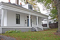 More images |
| Cambridge Military Library | Sackville Street Halifax NS | 44°38′38″N63°34′34″W / 44.644°N 63.576°W | Federal (3994) | Q16890066 |  More images |
| Carroll Building S-17 | CFB Halifax Halifax NS | 44°39′39″N63°35′38″W / 44.6608°N 63.5938°W | Federal (9840) |  | |
| Casemates | Fort McNab Halifax NS | 44°36′00″N63°30′55″W / 44.6°N 63.5152°W | Federal (11040) |  | |
| Cast Iron Façade / Coomb's Old English Shoe Store National Historic Site of Canada | 1883-1885 Granville Street Halifax NS | 44°38′57″N63°34′28″W / 44.6492°N 63.5745°W | Federal (1393) |  | |
| Cavalier Building | Halifax Citadel Halifax NS | 44°38′49″N63°34′50″W / 44.647°N 63.5805°W | Federal (2989) |  | |
| Christ Church | 50 Wentworth Street Dartmouth NS | 44°40′03″N63°34′05″W / 44.6675°N 63.5680°W | Dartmouth municipality (4583) | Q136500211 |  More images |
| Clam Harbour Archaeological Site - BeCr-04 | Clam Harbour Provincial Park Clam Harbour NS | 44°43′N62°52′W / 44.71°N 62.86°W | Nova Scotia (14895) | Upload Photo | |
| Cleverdon Building | 1709 Barrington Street Halifax NS | 44°34′28″N63°34′26″W / 44.5745°N 63.574°W | Halifax municipality (1510) | Q137176962 |  More images |
| Cole Harbour Meeting House | 1436 Cole Harbour Road Cole Harbour NS | 44°40′21″N63°28′12″W / 44.6725°N 63.4699°W | Nova Scotia (6651) | Upload Photo | |
| Cole Harbour Farm | 471-475 Poplar Drive Dartmouth NS | 44°40′21″N63°29′59″W / 44.6725°N 63.4997°W | Nova Scotia (6559), Dartmouth municipality (4204) | Q130549241 |  More images |
| Command Post | York Redoubt NHS Halifax NS | 44°35′30″N63°33′27″W / 44.5917°N 63.5575°W | Federal (6239) | Upload Photo | |
| Fire Command Post | York Redoubt NHS Halifax NS | 44°38′N63°33′W / 44.64°N 63.55°W | Federal (3203) |  | |
| Commanding Officer's Residence | 5425 Sackville Street Halifax NS | 44°38′38″N63°34′34″W / 44.644°N 63.576°W | Federal (11106) |  | |
| Commander's Residence | 830 Young Avenue, CFB Halifax Halifax NS | 44°39′39″N63°35′33″W / 44.6607°N 63.5925°W | Federal (4755) | Upload Photo | |
| Counterscarp Gallery | Halifax Citadel Halifax NS | 44°38′49″N63°34′50″W / 44.647°N 63.5805°W | Federal (2991) |  | |
| Cookhouse, Building 626 | York Redoubt NHS Halifax NS | 44°35′30″N63°33′27″W / 44.5917°N 63.5575°W | Federal (4419) |  | |
| Crystal Crescent Archaeological Site, Borden Number BcCv-01 to 03 | Crystal Crescent Provincial Park Sambro Island NS | 44°27′N63°37′W / 44.45°N 63.62°W | Nova Scotia (6514) | Upload Photo | |
| Currie Building, S37 | CFB Halifax Halifax NS | 44°39′39″N63°35′33″W / 44.6607°N 63.5925°W | Federal (9581) |  | |
| Defensive Casemates 5-6 | Halifax Citadel Halifax NS | 44°38′49″N63°34′50″W / 44.647°N 63.5805°W | Federal (4395) |  | |
| Defensive Casemates 51 and 52 | Halifax Citadel Halifax NS | 44°38′49″N63°34′50″W / 44.647°N 63.5805°W | Federal (4406) |  | |
| Defensive Casemates 57 and 58 | Halifax Citadel Halifax NS | 44°38′49″N63°34′50″W / 44.647°N 63.5805°W | Federal (4407) |  | |
| Dingle Tower | 260 Dingle Road Halifax NS | 44°37′49″N63°35′50″W / 44.6302°N 63.59735°W | Federal (12262), Halifax municipality (2447) | Q23019149 |  More images |
| Dingle Tower and Sir Sanford Fleming Park | 260 Dingle Road Halifax NS | 44°37′49″N63°35′50″W / 44.6302°N 63.5972°W | Halifax municipality (3079) | Q14875769 |  More images |
| Dockyard Terrace | Buildings 77, 78 and 79 HMC Dockyard Terrace Halifax NS | 44°39′27″N63°34′54″W / 44.6574°N 63.5818°W | Federal (11261) | 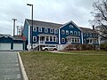 | |
| Elledge McElmon House | 52 King Street Dartmouth NS | 44°39′57″N63°34′00″W / 44.6659°N 63.5668°W | Dartmouth municipality (4135) | Q104591503 |  More images |
| Elsie Hume House | 8502 No. 3 Highway Black Point NS | 44°39′12″N63°59′00″W / 44.6532°N 63.9832°W | Nova Scotia (7823) | Upload Photo | |
| Former Artillery Stores, Building 91 | Fort Charlotte, Georges Island Halifax NS | 44°38′28″N63°33′33″W / 44.6412°N 63.5592°W | Federal (4413) | Upload Photo | |
| Former Artillery Stores, Building 629 | York Redoubt NHS Halifax NS | 44°35′30″N63°33′27″W / 44.5917°N 63.5575°W | Federal (4405) | 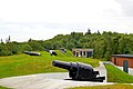 | |
| Former Field Forge Storage Building No. 90 | Fort Charlotte, Georges Island Halifax NS | 44°38′28″N63°33′34″W / 44.6412°N 63.5594°W | Federal (4414) | Upload Photo | |
| Former Guardhouse / Fire Engine House / Coal Stores, Building 114 | Fort Charlotte, Georges Island Halifax NS | 44°38′28″N63°33′34″W / 44.6411°N 63.5594°W | Federal (4418) | Upload Photo | |
| Former Guardroom and Prisoners' Quarters | Fort Charlotte, Georges Island Halifax NS | 44°38′28″N63°33′33″W / 44.6412°N 63.5591°W | Federal (4415) | Upload Photo | |
| Former Hampton Gray Memorial School, Building 14 | CFB Shearwater Halifax NS | 44°38′17″N63°29′53″W / 44.638°N 63.498°W | Federal (4227) | Upload Photo | |
| Former Stores Building 110 (Carpenter Shop and Smithy) | Georges Island Halifax NS | 44°38′28″N63°33′32″W / 44.641°N 63.559°W | Federal (2831) | Upload Photo | |
| Fort McNab National Historic Site of Canada | McNabs Island Halifax NS | 44°36′06″N63°30′54″W / 44.6016°N 63.5149°W | Federal (15810) | Q23010219 |  More images |
| Fultz House | 33 Sackville Drive Lower Sackville NS | 44°45′10″N63°39′54″W / 44.7528°N 63.6649°W | Lower Sackville municipality (7120) | Q5508489 |  More images |
| Gas House | Sambro Island NS | 44°28′N63°35′W / 44.47°N 63.59°W | Federal (4426) | 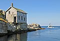 | |
| Georges Island National Historic Site of Canada | Georges Island Halifax NS | 44°38′29″N63°33′33″W / 44.6413°N 63.5593°W | Federal (7619) | Q3559232 |  More images |
| Government House National Historic Site of Canada | 1451 Barrington Street Halifax NS | 44°38′35″N63°34′19″W / 44.6431°N 63.5719°W | Federal (12641), Nova Scotia (2161) | Q5588906 |  More images |
| Grace Hiltz House | 47 Wentworth Street Dartmouth NS | 44°40′03″N63°34′06″W / 44.6674°N 63.5682°W | Dartmouth municipality (3080) | Q103211519 |  More images |
| Greenvale School | 130 Ochterloney Street Dartmouth NS | 44°40′09″N63°33′54″W / 44.6692°N 63.5649°W | Dartmouth municipality (3366) | Q103289254 |  More images |
| Gun Emplacement, Magazine and Crew Shelter 2 | Fort McNab Halifax NS | 44°36′01″N63°30′53″W / 44.6002°N 63.5147°W | Federal (9920) | Upload Photo | |
| Gun Emplacement, Magazine and Crew Shelter 1 | Fort McNab Halifax NS | 44°36′01″N63°30′58″W / 44.6004°N 63.516°W | Federal (9921) | | |
| Gun Emplacements 3 and 4, Radar Building, Left Magazine and Crew Shelter | Fort McNab Halifax NS | 44°35′59″N63°30′52″W / 44.5996°N 63.5145°W | Federal (9955) | Upload Photo | |
| Halifax Citadel National Historic Site of Canada | 5161 George Street Halifax NS | 44°38′50″N63°34′49″W / 44.6473°N 63.5804°W | Federal (7622) | Q321867 |  More images |
| Halifax Court House National Historic Site of Canada | 5250 Spring Garden Road Halifax NS | 44°38′37″N63°34′26″W / 44.6436°N 63.5738°W | Federal (12832), Nova Scotia (1677) | Q5642159 |  More images |
| Halifax Defense Complex, Georges Island, Fort Charlotte, South, Southeast and Southwest Caponiers | Fort Charlotte, Georges Island Halifax NS | 44°38′28″N63°33′34″W / 44.6412°N 63.5594°W | Federal (4417) | Upload Photo | |
| Halifax Dockyard National Historic Site of Canada | Barrington and Upper Water Streets Halifax NS | 44°39′32″N63°35′02″W / 44.6588°N 63.5838°W | Federal (16146) | Q7374530 |  More images |
| Halifax Public Gardens National Historic Site of Canada | Spring Garden Road Halifax NS | 44°38′34″N63°34′49″W / 44.6428°N 63.5803°W | Federal (2633), Halifax municipality (3221) | Q4901477 |  More images |
| Halifax Waterfront Buildings National Historic Site of Canada | Upper Water Street Halifax NS | 44°39′01″N63°34′24″W / 44.6502°N 63.5733°W | Federal (1614), Halifax municipality (1536) | Q16843488 | 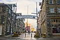 More images |
| Henry House | 1222 Barrington Street Halifax NS | 44°38′25″N63°34′15″W / 44.6404°N 63.5708°W | Federal (12665), Nova Scotia (4490), Halifax municipality (3383) | Q14816526 |  More images |
| Henry Elliot House | 99 Ochterloney Street Dartmouth NS | 44°40′06″N63°34′00″W / 44.6682°N 63.5667°W | Dartmouth municipality (7119) | Q117384828 |  More images |
| James Austin House | 287 Portland Street Dartmouth NS | 44°40′09″N63°33′23″W / 44.6692°N 63.5565°W | Dartmouth municipality (3467) | Q103843714 |  More images |
| James McKenzie House | 5675 North Street Halifax NS | 44°39′21″N63°35′36″W / 44.6558°N 63.5932°W | Halifax municipality (7092) | Q136484624 |  More images |
| James Orman House | 34 King Street Dartmouth NS | 44°39′55″N63°33′57″W / 44.6653°N 63.5659°W | Dartmouth municipality (4878) | Q105948272 | 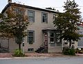 More images |
| James Simmonds House | 51-53 Pleasant Street Dartmouth NS | 44°40′06″N63°33′33″W / 44.6682°N 63.5591°W | Dartmouth municipality (5325) | Q106596470 |  More images |
| John Salisbury House | 42 Summit Street Dartmouth NS | 44°40′12″N63°33′20″W / 44.67°N 63.5555°W | Dartmouth municipality (4770) | Q130742364 |  More images |
| Johnstone Chittick House | 149 Prince Albert Road Dartmouth NS | 44°40′27″N63°33′37″W / 44.6742°N 63.5604°W | Dartmouth municipality (3853) | Q136500274 |  More images |
| Joseph Howe Austen House | 37 Pleasant Street Dartmouth NS | 44°40′07″N63°33′37″W / 44.6687°N 63.5604°W | Dartmouth municipality (3712) | Q103965215 | 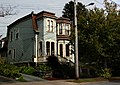 More images |
| Laboratory, former Building 92 | Fort Charlotte, Georges Island Halifax NS | 44°38′29″N63°33′35″W / 44.6413°N 63.5596°W | Federal (4412) | Upload Photo | |
| Lighthouse | Entrance to St. Margaret's Bay Peggys Cove NS | 44°29′28″N63°55′08″W / 44.491°N 63.919°W | Federal (2921) | Q1821453 |  More images |
| Terence Bay Lighthouse | Sandy Cove Road Terence Bay NS | 44°27′36″N63°42′20″W / 44.4601°N 63.7056°W | Federal (20721) | Q28375827 |  More images |
| Lower Battery | Fort Charlotte, Georges Island Halifax NS | 44°38′N63°33′W / 44.64°N 63.55°W | Federal (3163) | Upload Photo | |
| Main Magazine, Building 611 | York Redoubt NHS Halifax NS | 44°35′45″N63°33′20″W / 44.5958°N 63.5556°W | Federal (4420) |  | |
| Main Magazine and Tunnel Complex, Building 89 Classified Federal Heritage Building | Fort Charlotte, Georges Island Halifax NS | 44°38′27″N63°33′32″W / 44.6407°N 63.5590°W | Federal (3164) | Upload Photo | |
| Married Officers Quarters, former Building 125 Recognized Federal Heritage Building | Georges Island Halifax NS | 44°38′28″N63°33′32″W / 44.641°N 63.559°W | Federal (2830) | Upload Photo | |
| Mary Queen of Scots House | 1266 Queen Street Halifax NS | 44°38′25″N63°34′29″W / 44.6403°N 63.5747°W | Halifax municipality (6751) | Q131862419 |  More images |
| Maugher's Beach Light Tower | McNabs Island Halifax NS | 44°36′08″N63°32′01″W / 44.6023°N 63.5336°W | Federal (16003) | Q28375733 |  More images |
| Moirs Ltd. Power House | 926 Bedford Highway Bedford NS | 44°42′51″N63°40′41″W / 44.7141°N 63.678°W | Nova Scotia (2755), Bedford municipality (3150) | Q136812933 | 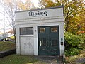 More images |
| Murray Building (S-15) | CFB Halifax Halifax NS | 44°39′39″N63°35′33″W / 44.6607°N 63.5925°W | Federal (9518) | 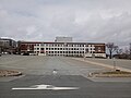 | |
| Mystery House | 95 King Street Dartmouth NS | 44°40′02″N63°34′11″W / 44.6671°N 63.5696°W | Dartmouth municipality (3482) | Q136528579 |  More images |
| North Caponiers, Building 82A & 82B | Fort Charlotte, Georges Island Halifax NS | 44°38′28″N63°33′34″W / 44.6412°N 63.5594°W | Federal (4416) | Upload Photo | |
| North Expense Magazine | Halifax Citadel Halifax NS | 44°38′49″N63°34′50″W / 44.647°N 63.5805°W | Federal (4408) |  | |
| Northeast Salient | Halifax Citadel Halifax NS | 44°38′49″N63°34′50″W / 44.647°N 63.5805°W | Federal (4409) |  | |
| Officers' Married Quarters | 5425 Sackville Street Halifax NS | 44°38′38″N63°34′37″W / 44.644°N 63.577°W | Federal (11111) |  | |
| Oil Stores and Artificers Shop | Fort McNab Halifax NS | 44°36′02″N63°30′54″W / 44.6005°N 63.515°W | Federal (9952) | Upload Photo | |
| Old Burying Ground National Historic Site of Canada | 1460 Barrington Street Halifax NS | 44°38′36″N63°34′22″W / 44.6433°N 63.5729°W | Federal (9982), Nova Scotia (6787) | Q7083564 |  More images |
| Owl Drug Store | 71 Portland Street Dartmouth NS | 44°39′57″N63°34′00″W / 44.6657°N 63.5667°W | Dartmouth municipality (3355) | Q136528560 |  More images |
| Pier 21 National Historic Site of Canada | 1055 Marginal Road Halifax NS | 44°38′18″N63°33′56″W / 44.6383°N 63.5655°W | Federal (7648) | Q512474 |  More images |
| Prince of Wales Tower National Historic Site of Canada | Tower Road Halifax NS | 44°37′17″N63°34′11″W / 44.6215°N 63.5697°W | Federal (7471,(3175) | Q7244404 |  More images |
| Quaker House | 57-59 Ochterloney Street Dartmouth NS | 44°40′01″N63°34′06″W / 44.667°N 63.5682°W | Nova Scotia (2577), Dartmouth municipality (3066) | Q16899015 |  More images |
| Ralston Building | 1557 Hollis Street Halifax NS | 44°38′45″N63°34′17″W / 44.6457°N 63.5713°W | Federal (9515) | Upload Photo | |
| Range Finder Bunker | York Redoubt NHS Halifax NS | 44°35′32″N63°33′00″W / 44.5921°N 63.5501°W | Federal (11658) |  | |
| Redan | Halifax Citadel Halifax NS | 44°38′49″N63°34′50″W / 44.647°N 63.5805°W | Federal (2996) |  | |
| Robert Innes House | 7 Newcastle Street Dartmouth NS | 44°40′02″N63°33′40″W / 44.6672°N 63.561°W | Dartmouth municipality (3624) | Q103964264 |  More images |
| St. John's Anglican Church | 8 Church Road Peggys Cove NS | 44°29′42″N63°54′56″W / 44.495°N 63.9156°W | Peggys Cove municipality (3320) |  | |
| St. Mary's Basilica National Historic Site of Canada | 1508 Barrington St. (at Spring Garden Rd.) Halifax NS | 44°38′39″N63°34′24″W / 44.6443°N 63.5732°W | Federal (12131) | Q908976 |  More images |
| St. Patrick's Roman Catholic Church | 2263 Brunswick Street Halifax NS | 44°39′15″N63°34′58″W / 44.6542°N 63.5829°W | Nova Scotia (15335) | Q16900626 |  More images |
| St. Paul's Anglican Church | 71 St. Paul's Lane French Village NS | 44°37′38″N63°55′26″W / 44.6271°N 63.9239°W | French Village municipality (8045) | Upload Photo | |
| Samuel Greenwood House | 63 King Street Dartmouth NS | 44°39′58″N63°34′04″W / 44.666°N 63.5678°W | Dartmouth municipality (4123) | Q104591445 |  More images |
| Scott Manor House | 15 Fort Sackville Road Bedford NS | 44°43′45″N63°39′36″W / 44.7293°N 63.6601°W | Nova Scotia (2987), Bedford municipality (3143) | Q14875767 |  More images |
| Searchlights 690, 691, 692 | York Redoubt NHS Halifax NS | 44°35′30″N63°33′27″W / 44.5917°N 63.5575°W | Federal (4404) |  | |
| Searchlight Emplacement Building 6 | McNab's Island Halifax NS | 44°35′45″N63°30′42″W / 44.5958°N 63.5117°W | Federal (10396) |  | |
| Sir Sandford Fleming Barn | 30-32 Dingle Road Halifax NS | 44°37′49″N63°35′50″W / 44.6302°N 63.5973°W | Nova Scotia (2451), Halifax municipality (9372) | Upload Photo | |
| Sir Sandford Fleming Cottage | 30 Dingle Road Halifax NS | 44°37′52″N63°36′11″W / 44.631°N 63.603°W | Nova Scotia (3848), Halifax municipality (2455) | Q136815627 |  More images |
| South Caponier | York Redoubt NHS Halifax NS | 44°35′30″N63°33′27″W / 44.5917°N 63.5575°W | Federal (4421) |  | |
| South Expense Magazine | Halifax Citadel Halifax NS | 44°38′49″N63°34′50″W / 44.647°N 63.5805°W | Federal (4425) |  | |
| Southeast Salient | Halifax Citadel Halifax NS | 44°38′N63°35′W / 44.64°N 63.58°W | Federal (3173) |  | |
| Sterns' Corner | 81 Alderney Drive Dartmouth NS | 44°39′52″N63°34′06″W / 44.6645°N 63.5682°W | Dartmouth municipality (3859) | Q136812869 |  More images |
| The Teachery | 9 Spring Street Bedford NS | 44°43′38″N63°40′00″W / 44.7273°N 63.6667°W | Bedford municipality (3381) | Upload Photo | |
| Thomas Boggs-Lawrence Hartshorne House | 53 Ochterloney Street Dartmouth NS | 44°40′00″N63°34′07″W / 44.6668°N 63.5685°W | Dartmouth municipality (3424) | Q131905349 |  More images |
| Thurso House | 289 Portland Street Dartmouth NS | 44°40′09″N63°33′23″W / 44.6691°N 63.5564°W | Dartmouth municipality (5085) | Q106357317 |  More images |
| Town Clock on Citadel Hill | Brunswick Street Halifax NS | 44°38′51″N63°34′39″W / 44.6474°N 63.5776°W | Federal (4260) | Q1725585 |  More images |
| Van Steenburgh and Polaris Buildings at The Bedford Institute of Oceanography | Baffin Boulevard Dartmouth NS | 44°40′58″N63°36′41″W / 44.6829°N 63.6113°W | Federal (4261) | Upload Photo | |
| Victoria Road United Baptist Church | 36 Victoria Road Dartmouth NS | 44°40′09″N63°34′01″W / 44.6691°N 63.567°W | Dartmouth municipality (3852) | Q133462271 |  More images |
| Wellington House | Building S12, Barrington Street (CFB Halifax) Halifax NS | 44°39′42″N63°35′37″W / 44.6618°N 63.5937°W | Federal (16584) | Q115331511 |  More images |
| West Ravelin Guardhouse | Halifax Citadel Halifax NS | 44°38′49″N63°34′50″W / 44.647°N 63.5805°W | Federal (4410) |  | |
| West Curtain Wall | Halifax Citadel Halifax NS | 44°38′49″N63°34′50″W / 44.647°N 63.5805°W | Federal (4411) |  | |
| William Black Memorial United Church | 10515 Peggy's Cove Road; No. 333 Highway Glen Margaret NS | 44°35′11″N63°54′55″W / 44.5864°N 63.9154°W | Nova Scotia (9465) | Upload Photo | |
| William Walker House | 119 Prince Albert Road Dartmouth NS | 44°40′21″N63°33′44″W / 44.6726°N 63.5621°W | Dartmouth municipality (3566) | Q136500244 |  More images |
| York Manuel Fish Shed and Store | 32 Lobster Lane Peggys Cove NS | 44°29′37″N63°54′58″W / 44.4936°N 63.9161°W | Nova Scotia (14684) | Q137181100 |  More images |
| York Redoubt National Historic Site of Canada | Shore Road and Purcell's Cove Road Halifax NS | 44°35′43″N63°33′14″W / 44.5952°N 63.5539°W | Federal (7746) | Q8055521 |  More images |
| Leadley House | 47 North Street Dartmouth NS | 44°40′05″N63°34′07″W / 44.668°N 63.5685°W | Dartmouth municipality (6718) | Q136500203 |  More images |
| Charles A. Robson House | 64 Queen Street Dartmouth NS | 44°40′02″N63°33′58″W / 44.6671°N 63.5661°W | Dartmouth municipality (7252) | Q117508462 |  More images |
| James-Robson House | 62 Queen Street Dartmouth NS | 44°40′01″N63°33′58″W / 44.667°N 63.5662°W | Dartmouth municipality (7253) | Q136814508 |  More images |
| Wesley Forbes House | 41 Pleasant Street Dartmouth NS | 44°40′07″N63°33′37″W / 44.6686°N 63.5602°W | Dartmouth municipality (7254) | Q117508868 |  More images |
| 90-92 Ochterloney Street | 90-92 Ochterloney Street Dartmouth NS | 44°40′04″N63°34′01″W / 44.6679°N 63.5669°W | Dartmouth municipality (10385) | Q136484650 |  More images |
| Oakwood House | 88A Crichton Avenue Dartmouth NS | 44°40′34″N63°33′46″W / 44.676°N 63.5628°W | Dartmouth municipality (3354) | Upload Photo | |
| 70 Victoria Road | 70 Victoria Road Dartmouth NS | 44°40′14″N63°34′11″W / 44.6706°N 63.5698°W | Dartmouth municipality (8074) | Q136528528 |  More images |
| Local Council of Women of Halifax House | 989 Young Ave Halifax NS | 44°38′03″N63°34′32″W / 44.6343°N 63.5755°W | Halifax municipality (3109) | Q115332034 |  More images |
| South Magazine and Shifting Room Classified Federal Heritage Building | Halifax Citadel Halifax NS | 44°38′59″N63°34′46″W / 44.6496°N 63.5795°W | Federal (3169) | | |
| Bengal Lancers Property | 1690 Bell Road Halifax NS | 44°38′43″N63°35′00″W / 44.6454°N 63.5834°W | Halifax municipality (3316) | Q103276214 |  More images |
| Thorndean | 5680 Inglis Street Halifax NS | 44°38′03″N63°34′31″W / 44.6343°N 63.5752°W | Nova Scotia (7288), Halifax municipality (3380) | Q117509304 |  More images |
| Carlton Victorian Streetscape | 1452-1489 Carlton Street Halifax NS | 44°38′25″N63°35′05″W / 44.6402°N 63.5848°W | Halifax municipality (3584) | Upload Photo | |
| James Rose House | 6201 Shirley Street Halifax NS | 44°38′41″N63°35′43″W / 44.6446°N 63.5953°W | Halifax municipality (3824) | Q136814450 |  More images |
| Smith Victorian Streetscape | 5214-5250 Smith Street Halifax NS | 44°38′12″N63°34′14″W / 44.6367°N 63.5705°W | Halifax municipality (3851) |  | |
| Tower Victorian Streetscape | 1041-1105 Tower Road Halifax NS | 44°38′07″N63°34′41″W / 44.6354°N 63.578°W | Halifax municipality (4011) |  More images | |
| 5651 - 5691 Inglis Street | 5651-5691 Inglis Street Halifax NS | 44°38′05″N63°34′31″W / 44.6346°N 63.5752°W | Federal (3953) |  | |
| 5721 - 5765 Inglis Street | 5721-5765 Inglis Street Halifax NS | 44°38′03″N63°34′38″W / 44.6343°N 63.5772°W | Halifax municipality (4117) | Q136528818 |  More images |
| Oakland Lodge | 1124 Robie Street Halifax NS | 44°38′06″N63°35′05″W / 44.635°N 63.5847°W | Halifax municipality (4138) | Q104591526 |  More images |
| Senator William Dennis House | 1731 Rosebank Avenue; 6503 Jubilee Road Halifax NS | 44°38′26″N63°36′04″W / 44.6405°N 63.6012°W | Halifax municipality (4923) | Q136497156 |  More images |
| The Bower | 5918 Rogers Drive Halifax NS | 44°37′43″N63°34′46″W / 44.6286°N 63.5795°W | Nova Scotia (5224), Halifax municipality (6849) | Q137177026 |  More images |
| Universalist Unitarian Church of Halifax | 5500 Inglis Street Halifax NS | 44°38′06″N63°34′22″W / 44.6349°N 63.5729°W | Nova Scotia (5768) | Q107302325 |  More images |
| Wright Building | 1672-74 Barrington Street Halifax NS | 44°38′49″N63°34′26″W / 44.6470°N 63.5740°W | Halifax municipality (10700) | Q136816275 |  More images |
| George Wright House | 989 Young Avenue Halifax NS | 44°38′03″N63°34′32″W / 44.6343°N 63.5755°W | Nova Scotia (7324) | Q115332034 |  More images |
| Fernwood National Historic Site of Canada | 700 Franklyn Street Halifax NS | 44°37′34″N63°34′40″W / 44.626°N 63.5779°W | Federal (7603) | Q23009412 |  More images |
| Fort Massey United Church | 1181 Queen Street Halifax NS | 44°38′20″N63°34′24″W / 44.6389°N 63.5733°W | Nova Scotia (7704) | Q115330460 |  More images |
| 1606 Bell Road | 1606 Bell Road Halifax NS | 44°38′41″N63°34′52″W / 44.6447°N 63.5811°W | Halifax municipality (10631) | Q136500389 |  More images |
| Former City Club | 1580 Barrington Street Halifax NS | 44°38′45″N63°34′25″W / 44.6457°N 63.5735°W | Halifax municipality (1390) | Q136497181 |  More images |
| Sievert's Tobacco Building | 1573 Barrington Street Halifax NS | 44°38′45″N63°34′23″W / 44.6457°N 63.5731°W | Halifax municipality (1392) | Q136497210 |  More images |
| Colwell Building | 1673 Barrington Street Halifax NS | 44°38′49″N63°34′25″W / 44.6469°N 63.5737°W | Halifax municipality (1507) | Q136802806 |  More images |
| Shaw Building | 1855-1859 Hollis Street Halifax NS | 44°38′59″N63°34′25″W / 44.6497°N 63.5737°W | Halifax municipality (1534) | Q137177053 |  More images |
| Former Church of England Institute | 1588 Barrington Street Halifax NS | 44°38′45″N63°34′25″W / 44.6459°N 63.5735°W | Halifax municipality (2369) | Q131139884 |  More images |
| Macara-Barnstead Building | 1796-1798 Granville Street Halifax NS | 44°38′56″N63°34′27″W / 44.6488°N 63.5742°W | Halifax municipality (2459) | Q137177309 |  More images |
| St. Paul's Church (Halifax) National Historic Site of Canada | 1747 Argyle Street; 1 St. Paul's Hill Halifax NS | 44°38′51″N63°34′28″W / 44.6475°N 63.5745°W | Federal (12134), Nova Scotia (3065) | Q1547982 |  More images |
| Grand Parade | 1790 Argyle Street Halifax NS | 44°38′54″N63°34′30″W / 44.6482°N 63.5749°W | Halifax municipality (3146) | Q5594872 |  More images |
| The Benjamin Wier House | 1459 Hollis Street Halifax NS | 44°38′38″N63°34′15″W / 44.6438°N 63.5707°W | Nova Scotia (3157), Halifax municipality (3888) | Q110974280 |  More images |
| Geldert (Old Bowes) | 5136-5138 Prince Street Halifax NS | 44°38′51″N63°34′20″W / 44.6476°N 63.5723°W | Halifax municipality (3208) |  | |
| Imperial Oil Building | 1860 Upper Water Street Halifax NS | 44°38′59″N63°34′25″W / 44.6498°N 63.5735°W | Halifax municipality (3209) | Q137177095 |  More images |
| Old Fire Station | 1679 Bedford Row Halifax NS | 44°38′51″N63°34′19″W / 44.6476°N 63.5719°W | Halifax municipality (3211) | Q136500429 |  More images |
| VIA Rail Station | 1161 Hollis Street Halifax NS | 44°38′23″N63°34′06″W / 44.6396°N 63.5684°W | Federal (4521) | Q3095762 |  More images |
| Royal Bank Building | 5509 - 5513 Young Street Halifax NS | 44°39′45″N63°35′56″W / 44.6624°N 63.5988°W | Halifax municipality (3438) | Q137177365 |  More images |
| The Bank of Nova Scotia | 1709 Hollis Street Halifax NS | 44°38′52″N63°34′21″W / 44.6478°N 63.5726°W | Nova Scotia (6287), Halifax municipality (3251) | Q131905181 |  More images |
| Bollard House | 1597 Dresden Row Halifax NS | 44°38′41″N63°34′43″W / 44.6447°N 63.5787°W | Nova Scotia (3971), Halifax municipality (3275) | Q136500340 |  More images |
| Mitchell House | 1684 Lower Water Street Halifax NS | 44°38′52″N63°34′18″W / 44.6477°N 63.5716°W | Halifax municipality (3276) | Q136817821 |  More images |
| Lenoir Building | 1659-1663 Hollis Street Halifax NS | 44°38′50″N63°34′20″W / 44.6471°N 63.5723°W | Halifax municipality (3294) | Q136500409 |  More images |
| Harrington MacDonald-Briggs Building | 1865 Hollis Street; 1866 Upper Water Street Halifax NS | 44°38′59″N63°34′26″W / 44.6498°N 63.5738°W | Halifax municipality (3375) |  | |
| Fishwick & Company Building | 1861 Hollis Street Halifax NS | 44°38′59″N63°34′26″W / 44.6497°N 63.5738°W | Halifax municipality (3379) | | |
| Granville Mall Streetscape | 1854-1895 Granville Street Halifax NS | 44°38′59″N63°34′29″W / 44.6498°N 63.5746°W | Halifax municipality (3398) | | |
| P. Martin Liquors Building | 1870 Upper Water Street Halifax NS | 44°39′00″N63°34′25″W / 44.65°N 63.5737°W | Halifax municipality (3433) | Q137177493 |  More images |
| Edward Goreham House | 5170-5172 Bishop Street Halifax NS | 44°38′35″N63°34′16″W / 44.6431°N 63.5712°W | Halifax municipality (3451) | Q137177615 |  More images |
| Charles H. Willis House | 5178-5180 Bishop Street Halifax NS | 44°38′35″N63°34′17″W / 44.643°N 63.5713°W | Halifax municipality (3452) | Q136815585 |  More images |
| William Fraser House | 5182-5184 Bishop Street Halifax NS | 44°38′35″N63°34′17″W / 44.643°N 63.5714°W | Halifax municipality (3468) | Q137177638 |  More images |
| Joseph Seeton House | 1253 Barrington Street Halifax NS | 44°38′28″N63°34′15″W / 44.6411°N 63.5707°W | Halifax municipality (3530) | Q26220639 |  More images |
| Halliburton House | 5184 Morris Street Halifax NS | 44°38′30″N63°34′15″W / 44.6418°N 63.5708°W | Halifax municipality (3621) | Q136815154 |  More images |
| Lithgow House | 5172 Morris Street Halifax NS | 44°38′30″N63°34′14″W / 44.6418°N 63.5705°W | Halifax municipality (3622) |  | |
| Pryor-Binney House | 5178 Morris Street Halifax NS | 44°38′30″N63°34′14″W / 44.6418°N 63.5706°W | Halifax municipality (3623) |  | |
| People's Bank Building | 5159 Duke Street Halifax NS | 44°38′59″N63°34′25″W / 44.6496°N 63.5737°W | Halifax municipality (3735) | Q136497203 |  More images |
| Story-Wilson House | 5270 Morris Street Halifax NS | 44°38′28″N63°34′23″W / 44.6412°N 63.573°W | Halifax municipality (3854) | Q137179712 |  More images |
| Halifax Academy | 1649 Brunswick Street Halifax NS | 44°38′45″N63°34′34″W / 44.6458°N 63.5761°W | Nova Scotia (5767), Halifax municipality (3896) | Q39054268 |  More images |
| South Park Victorian Streetscape | 1263-1283 and 1293 South Park Street Halifax NS | 44°38′22″N63°34′41″W / 44.6394°N 63.578°W | Halifax municipality (4008) | Q136500250 |  More images |
| Ellen (Allie) Ahern House | 5308 South Street Halifax NS | 44°38′21″N63°34′24″W / 44.6391°N 63.5732°W | Halifax municipality (4181) | Q136499787 |  More images |
| Robertson's Hardware & Warehouse | 1675 Lower Water Street Halifax NS | 44°38′52″N63°34′17″W / 44.6478°N 63.5713°W | Halifax municipality (4886) | Q105949061 |  More images |
| Alex Mclean House | 1328-1332 Hollis Street Halifax NS | 44°38′33″N63°34′13″W / 44.6426°N 63.5704°W | Halifax municipality (5324) | Q131144269 |  More images |
| National Film Board Building | 1572 Barrington Street Halifax NS | 44°38′43″N63°34′26″W / 44.6453°N 63.5738°W | Halifax municipality (5553) | Q131903445 |  More images |
| Pacific Building | 1537 Barrington Street Halifax NS | 44°38′42″N63°34′22″W / 44.6451°N 63.5727°W | Halifax municipality (5640) | Q136818130 |  More images |
| Prince and Hollis Buildings | 5136-38 Prince Street; 5140 Prince Street; 5144 Prince Street; 1695 Hollis Street Halifax NS | 44°38′51″N63°34′21″W / 44.6475°N 63.5724°W | Nova Scotia (6642) | | |
| William DeBlois House | 1346 Hollis Street Halifax NS | 44°38′34″N63°34′14″W / 44.6429°N 63.5706°W | Halifax municipality (6785) | Q136816026 |  More images |
| St. Mary's Basilica | 5221 Spring Garden Road Halifax NS | 44°38′40″N63°34′24″W / 44.6444°N 63.5733°W | Nova Scotia (7218) | Q908976 | More images |
| Grafton Street Methodist Church | 1544 Grafton Street Halifax NS | 44°38′41″N63°34′30″W / 44.6446°N 63.575°W | Nova Scotia (7332) | Q115331245 |  More images |
| Morse's Teas | 1877-79 Hollis Street Halifax NS | 44°39′00″N63°34′26″W / 44.65°N 63.574°W | Halifax municipality (7955) | Q136816345 |  More images |
| Nova Scotia Furnishings | 1668 Barrington Street Halifax NS | 44°38′48″N63°34′26″W / 44.6466°N 63.5739°W | Halifax municipality (7957) | Q136497188 |  More images |
| G.M. Smith Building | 1715-19 Barrington Street Halifax NS | 44°38′51″N63°34′27″W / 44.6475°N 63.5741°W | Halifax municipality (7993) | Q137179735 |  More images |
| St. Matthew's Manse | 1355 Barrington Street Halifax NS | 44°38′34″N63°34′18″W / 44.6427°N 63.5718°W | Halifax municipality (8015) | Q136816355 |  More images |
| W. M. Brown Building | 1549-51 Barrington Street Halifax NS | 44°38′43″N63°34′23″W / 44.6452°N 63.573°W | Halifax municipality (8069) | Q136816136 |  More images |
| 1724 Granville Street | 1724 Granville Street Halifax NS | 44°38′52″N63°34′25″W / 44.6477°N 63.5736°W | Halifax municipality (10536) | Upload Photo | |
| Black-Binney House National Historic Site of Canada | 1472 Hollis Street Halifax NS | 44°38′36″N63°34′14″W / 44.6432°N 63.5706°W | Federal (10583), Halifax municipality (6850) | Q23011176 |  More images |
| Keith Hall and Brewery | 1475 Hollis Street; 1496 Lower Water Street Halifax NS | 44°38′41″N63°34′17″W / 44.6446°N 63.5713°W | Halifax municipality (11003) |  | |
| Building 6 | Royal Artillery Park Halifax NS | 44°38′42″N63°34′35″W / 44.6451°N 63.5765°W | Federal (11269) |  | |
| Halifax City Hall National Historic Site of Canada | 1841 Argyle Street Halifax NS | 44°38′56″N63°34′30″W / 44.6488°N 63.575°W | Federal (12061), Halifax municipality (3277) | Q1352771 |  More images |
| Granville Block National Historic Site of Canada | Granville, Hollis and Duke Streets Halifax NS | 44°38′59″N63°34′28″W / 44.6498°N 63.5744°W | Federal (12463) | Q23011167 |  More images |
| S.S. Acadia National Historic Site of Canada | 1675 Lower Water Street Halifax NS | 44°38′53″N63°34′12″W / 44.648°N 63.5701°W | Federal (12741) | Q5014257 | More images |
| HMCS Sackville National Historic Site of Canada | 1655 Lower Water Street Halifax NS | 44°38′51″N63°34′12″W / 44.6474°N 63.57°W | Federal (14548) | Q5630909 |  More images |
| Jonathan McCully House National Historic Site of Canada | 2507 Brunswick Street Halifax NS | 44°39′27″N63°35′17″W / 44.6574°N 63.5881°W | Federal (1144) | Q23015905 |  More images |
| Africville National Historic Site of Canada | Seaview Park Halifax NS | 44°40′28″N63°37′10″W / 44.6744°N 63.6194°W | Federal (1153) | Q2826181 |  More images |
| Charles F. Dewolf House | 2125 Brunswick Street Halifax NS | 44°39′11″N63°34′53″W / 44.6531°N 63.5813°W | Halifax municipality (1545) | Q136528618 |  More images |
| Ott-Beamish Cottage | 2229 Brunswick Street Halifax NS | 44°39′14″N63°34′57″W / 44.6538°N 63.5825°W | Halifax municipality (1966) | Q136499924 |  More images |
| David Starr House | 2415 Brunswick Street Halifax NS | 44°39′22″N63°35′09″W / 44.6562°N 63.5859°W | Halifax municipality (2380) | Q136499682 |  More images |
| West-Hawkins House | 2421 Brunswick Street Halifax NS | 44°39′23″N63°35′10″W / 44.6563°N 63.586°W | Halifax municipality (2456) | Q136499957 |  More images |
| James West House | 2461-2463 Brunswick Street Halifax NS | 44°39′24″N63°35′13″W / 44.6568°N 63.5869°W | Halifax municipality (2457) | Q136499717 |  More images |
| Fraser House | 2223 Brunswick Street Halifax NS | 44°39′14″N63°34′57″W / 44.6538°N 63.5824°W | Halifax municipality (2458) | Q136499808 |  More images |
| Halifax Forum | 2901 Windsor Street Halifax NS | 44°39′20″N63°36′17″W / 44.6555°N 63.6046°W | Halifax municipality (3142) | Q5642175 |  More images |
| Smyth House | 2237 Brunswick Street Halifax NS | 44°39′14″N63°34′58″W / 44.6539°N 63.5827°W | Halifax municipality (3247) | Q136499650 |  More images |
| Huestis House | 2275 Brunswick Street Halifax NS | 44°39′16″N63°35′00″W / 44.6544°N 63.5834°W | Halifax municipality (3248) | Q131842587 |  More images |
| Hennessey Place Hydrostones | 5520-5532 Hennessey Place Halifax NS | 44°39′44″N63°35′59″W / 44.6623°N 63.5997°W | Halifax municipality (3377) | Q136528504 |  More images |
| Fleming House | 2549-2553 Brunswick Street Halifax NS | 44°39′28″N63°35′19″W / 44.6579°N 63.5885°W | Halifax municipality (3378) | Q131912415 |  More images |
| Halifax Relief Commission Building | 5555 Young Street Halifax NS | 44°39′42″N63°35′59″W / 44.6618°N 63.5998°W | Halifax municipality (3439) | Q136818051 |  More images |
| Hydrostone Market | 5515-5547 Young Street Halifax NS | 44°39′44″N63°35′58″W / 44.6621°N 63.5994°W | Halifax municipality (3565) | Q132334831 |  More images |
| West-Vaux House | 2427-2429 Brunswick Street Halifax NS | 44°39′23″N63°35′10″W / 44.6563°N 63.5862°W | Halifax municipality (3585) | Q136499893 |  More images |
| West-Webster House | 2138 Brunswick Street Halifax NS | 44°39′10″N63°34′55″W / 44.6528°N 63.5819°W | Nova Scotia (3679) | Q136499619 |  More images |
| Walden Square | 5419 Portland Place Halifax NS | 44°39′08″N63°34′52″W / 44.6521°N 63.5812°W | Halifax municipality (3731) | Q137179768 |  More images |
| St. Mark's Church | 5522 Russell Street Halifax NS | 44°39′40″N63°35′51″W / 44.6611°N 63.5974°W | Halifax municipality (3826) | Q136815171 |  More images |
| Avery House | 2370 Moran Street Halifax NS | 44°39′07″N63°35′24″W / 44.652°N 63.59°W | Halifax municipality (3849) | Q137177162 |  More images |
| Universalist Church | 2146 Brunswick Street Halifax NS | 44°39′11″N63°34′55″W / 44.653°N 63.582°W | Nova Scotia (3897) | Upload Photo | |
| West-Buley House | 2146 Brunswick Street Halifax NS | 44°39′11″N63°34′55″W / 44.6531°N 63.582°W | Nova Scotia (7394) | Upload Photo | |
| Princess Place Victorian Townhouses | 2323-2337 Princess Place Halifax NS | 44°39′06″N63°35′27″W / 44.6517°N 63.5908°W | Halifax municipality (4010) |  | |
| Churchfield Barracks | 2046-2068 Brunswick Street Halifax NS | 44°39′06″N63°34′49″W / 44.6517°N 63.5802°W | Halifax municipality (4122) |  | |
| Henry Busch House | 2575-2581 Creighton Street Halifax NS | 44°39′23″N63°35′29″W / 44.6565°N 63.5913°W | Halifax municipality (4162) | Upload Photo | |
| Stone House | 25049 Highway no. 7 Port Dufferin NS | 44°54′17″N62°23′45″W / 44.9046°N 62.3957°W | Port Dufferin municipality (7093) | Upload Photo | |
| St. George's Anglican / Round Church National Historic Site of Canada | 2222 Brunswick Street Halifax NS | 44°39′14″N63°34′59″W / 44.6538°N 63.5831°W | Federal (4446), Nova Scotia (6566), Halifax municipality (3403) | Q14875774 |  More images |
| Little Dutch (Deutsch) Church National Historic Site of Canada | 2393 Brunswick Street Halifax NS | 44°39′21″N63°35′08″W / 44.6558°N 63.5856°W | Federal (12462), Nova Scotia (6482), Halifax municipality (3252) | Q15242497 |  More images |
| West-Osler House | 2140 Brunswick Street Halifax NS | 44°39′10″N63°34′55″W / 44.6529°N 63.582°W | Nova Scotia (7395) | Q136499602 |  More images |
| Hydrostone District National Historic Site of Canada | Hydrostone neighbourhood Halifax NS | 44°39′47″N63°36′09″W / 44.663°N 63.6025°W | Federal (7625) | | |
| Church of Holy Redeemer | 2128 Brunswick Street Halifax NS | 44°39′10″N63°34′54″W / 44.6529°N 63.5816°W | Halifax municipality (7956) |  | |
| 5522 North Street | 5522 North Street Halifax NS | 44°39′24″N63°35′30″W / 44.6568°N 63.5917°W | Halifax municipality (10382) | Q136484569 |  More images |
| 5516 North Street | 5516 North Street Halifax NS | 44°39′25″N63°35′30″W / 44.6569°N 63.5917°W | Halifax municipality (10387) | Q136484504 |  More images |
| 2548 Gottingen Street | 2548 Gottingen Street Halifax NS | 44°39′25″N63°35′26″W / 44.657°N 63.5906°W | Halifax municipality (10574) | Q136499703 |  More images |
| 5355 Russell Street | 5355 Russell Street Halifax NS | 44°39′45″N63°35′44″W / 44.6626°N 63.5956°W | Halifax municipality (10701) | Q136484488 |  More images |
| Halifax Drill Hall National Historic Site of Canada | 2667 North Park Street Halifax NS | 44°39′06″N63°35′13″W / 44.6518°N 63.5869°W | Federal (13395,(3160) | Q5642122 | 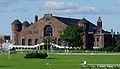 More images |
| Akins House National Historic Site of Canada | 2151 Brunswick Street Halifax NS | 44°39′12″N63°34′55″W / 44.6533°N 63.582°W | Federal (13963) | Q23011174 | 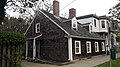 More images |
| Chebucto School | 6199 Chebucto Road Halifax NS | 44°39′01″N63°35′52″W / 44.6502°N 63.5977°W | Halifax municipality (3479) | Q131871490 |  More images |
| Pineo House (Caribou Lodge) | 6 Armada Drive Halifax NS | 44°40′26″N63°38′50″W / 44.6738°N 63.6473°W | Halifax municipality (3376) | Q130743104 | 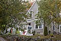 More images |
| D'Anville's Encampment National Historic Site of Canada | Centennial Park, Bedford Highway Halifax NS | 44°40′29″N63°38′48″W / 44.6747°N 63.6466°W | Federal (14826) | Q23009404 |  More images |
| Mont Blanc Anchor Site | 110 Spinnaker Drive Halifax NS | 44°38′16″N63°36′58″W / 44.6377°N 63.6162°W | Halifax municipality (2582) | Q96003590 |  More images |
| 11 St. Margaret's Bay Road | 11 St. Margaret's Bay Road Halifax NS | 44°38′30″N63°37′22″W / 44.6416°N 63.6229°W | Halifax municipality (10926) | Q137179791 |  More images |
| St. Augustine's Chapel | 68 Parkhill Road Halifax NS | 44°37′43″N63°35′50″W / 44.6287°N 63.5971°W | Halifax municipality (2383) | Upload Photo | |
| Building S-27 | CFB Halifax Halifax NS | 44°39′32″N63°35′38″W / 44.659°N 63.594°W | Federal (2930) | Upload Photo | |
| Rose Bank Cottage | 268 Highway 357 Musquodoboit Harbour NS | 44°47′48″N63°09′31″W / 44.7968°N 63.1585°W | Nova Scotia (3408) | Q137162338 | Upload Photo |
| Musquodoboit Harbour Railway Museum | 7895 Highway 7 Musquodoboit Harbour NS | 44°54′14″N62°24′01″W / 44.9039°N 62.4002°W | Musquodoboit Harbour municipality (5334) | Q106596475 |  More images |
| Lighttower | Sambro Island NS | 44°26′00″N63°34′00″W / 44.4333°N 63.5667°W | Federal (3204) | Q7409095 |  More images |
| Mackey House | 1137 Ketch Harbour Road Ketch Harbour NS | 44°29′31″N63°33′10″W / 44.4919°N 63.5528°W | Nova Scotia (15383) | Upload Photo | |
| Lock #5, Shubenacadie Canal | 53 Kings Road Wellington NS | 44°51′50″N63°37′26″W / 44.8639°N 63.624°W | Nova Scotia (1788) | Q136802783 | Upload Photo |
| St. James United Church | 43 Old Taylor Head Road Spry Bay NS | 44°50′19″N62°34′59″W / 44.8385°N 62.5831°W | Spry Bay municipality (7249) | Upload Photo | |
| Memory Lane Heritage Village | 28 Clam Harbour Road Lake Charlotte NS | 44°45′50″N62°56′46″W / 44.764°N 62.946°W | Lake Charlotte municipality (8044) | Upload Photo | |
| 782 East Chezzetcook Road | 782 East Chezzetcook Road East Chezzetcook NS | 44°43′14″N63°14′08″W / 44.7206°N 63.2355°W | East Chezzetcook municipality (8046) | Upload Photo | |
| Dorey House | 15 Dorey Lane Queensland NS | 44°38′21″N64°01′02″W / 44.6393°N 64.0171°W | Queensland municipality (7250) | Upload Photo | |
| MacPhee House | 22404 Highway 7 Sheet Harbour NS | 44°55′39″N62°32′37″W / 44.9276°N 62.5435°W | Sheet Harbour municipality (10927) | Upload Photo | |
| 1991 Prince Arthur Street | 1991 Prince Arthur Street Halifax NS | 44°38′28″N63°36′32″W / 44.6411°N 63.6089°W | Halifax municipality (10459) | Q136815356 |  More images |